The spectacular, synchronized aerial displays known as drone light shows have transformed from a novel concept into a mainstream medium for artistic expression and large-scale event spectacles. These shows involve the coordinated flight of hundreds or even thousands of unmanned aerial vehicles (UAVs) to create intricate, illuminated patterns and animations in the night sky. At the heart of achieving this mesmerizing choreography lies an uncompromising requirement for precise three-dimensional positioning. Centimeter-level accuracy is not merely a performance enhancer; it is the fundamental prerequisite for safety, enabling dense formations and complex maneuvers without the risk of catastrophic mid-air collisions. This article explores the pivotal role of Real-Time Kinematic (RTK) satellite positioning technology in enabling and elevating the modern drone light show.
1. Fundamentals of RTK Positioning Technology
RTK is a sophisticated technique that enhances the precision of standard Global Navigation Satellite System (GNSS) positioning from meter-level to centimeter-level in real-time. It is built upon the infrastructure of GNSS constellations, including GPS (USA), GLONASS (Russia), BeiDou (China), and Galileo (Europe).
The core principle involves differential correction. The system comprises two primary components: a stationary base station and one or more mobile stations (rovers) mounted on the drones. The base station is placed at a precisely surveyed, known location. As it receives signals from multiple satellites, it calculates its apparent position based on these signals. Since its true position is known, it can compute the error present in the satellite signals at that specific location and time. This error arises from various atmospheric delays (ionospheric and tropospheric) and satellite orbit/clock inaccuracies.
These computed error corrections are formatted—typically using protocols like RTCM (Radio Technical Commission for Maritime services)—and transmitted in real-time to the drone’s RTK receiver via a reliable data link (e.g., 4G/5G, radio modem). The drone’s receiver applies these corrections to its own raw satellite measurements, effectively canceling out common-mode errors and yielding a highly accurate position fix.
The primary measurements used are the carrier phase of the GNSS signal, which is far more precise than the code (pseudorange) measurements used in standard GNSS. The key equation for a pseudorange measurement P from a satellite to a receiver is:
$$ P = \rho + c(\delta t_r – \delta t^s) + I + T + \epsilon $$
Where:
ρ is the true geometric range,
c is the speed of light,
δt_r and δt^s are receiver and satellite clock errors,
I and T are ionospheric and tropospheric delays,
ε encompasses other errors and noise.
In RTK, the base station computes corrections for these error terms (clock biases, I, T) and sends them. The rover uses these to resolve the integer ambiguity in its carrier phase measurements, leading to a precise relative vector (baseline) between the base and the rover. The rover’s absolute position is then:
$$ \mathbf{X_{rover}} = \mathbf{X_{base}} + \Delta\mathbf{X} $$
where ΔX is the high-accuracy baseline vector solved via carrier-phase integer ambiguity resolution.
The transformative impact of RTK on UAV operational accuracy is clearly illustrated in the following comparison table:
| Operational Mode | Typical Horizontal Accuracy | Typical Vertical Accuracy | Suitability for Drone Light Shows |
|---|---|---|---|
| Standard GNSS (GPS/BeiDou) | 1.5 – 5 meters | 2 – 10 meters | Unacceptable for close formation flying. High risk of collision. |
| Visual Positioning (VPS) | 0.1 – 0.5 meters | 0.1 – 0.5 meters | Suitable for very low-altitude, slow flight. Requires textured ground and good lighting. |
| RTK Positioning | 0.01 – 0.05 meters | 0.01 – 0.1 meters | Essential. Enables centimeter-precise 3D positioning globally, regardless of ground texture or lighting. |
2. Key Factors Influencing RTK Performance in Drone Swarms
The exceptional precision of RTK is not unconditional. Its performance in a drone light show environment is susceptible to several critical factors. Understanding and managing these is paramount for a successful show.
2.1 Satellite Geometry and Visibility
The geometric distribution of satellites, quantified by the Position Dilution of Precision (PDOP), directly impacts accuracy. A lower PDOP value indicates a more favorable satellite geometry. The relationship is:
$$ \text{Position Error} = \text{PDOP} \times \text{Measurement Error} $$
Shows performed in urban canyons or near tall structures can suffer from signal blockage, reducing the number of visible satellites and degrading geometry, which increases PDOP and thus positional error. Pre-flight planning must include an analysis of satellite visibility for the show’s time and location.
2.2 Base Station Integrity and Siting
The base station is the accuracy foundation. Any error in its surveyed coordinates propagates directly to the entire swarm. Its stability is crucial; even minor movement (e.g., tripod settling) introduces errors. The distance between the base and the swarm (baseline length) is also a factor. While modern RTK can work over tens of kilometers, atmospheric decorrelation increases with distance, potentially slowing integer ambiguity resolution or reducing reliability. For very large shows or challenging environments, a network of base stations or a Cloud/Network RTK (NRTK/CORS) service is preferable, providing virtual corrections that are more consistent over a wide area.
2.3 Environmental and Radio Frequency Interference (RFI)
This is one of the most significant threats to a drone light show. The operating environment is often electromagnetically hostile.
- Multipath: GNSS signals reflecting off buildings, water, or the ground can create multiple paths to the antenna, corrupting the phase measurement.
- Atmospheric Conditions: Severe ionospheric activity or turbulent tropospheric conditions can delay signals unpredictably, challenging the differential correction process.
- Radio Frequency Interference (RFI): Intentional or unintentional RFI is a major concern. Sources include:
- High-power radar systems
- Illegal GNSS jammers
- Improperly shielded industrial equipment
- High-density communication transmitters (e.g., event-side broadcast equipment, 5G stations).
RFI can degrade signal-to-noise ratio (SNR), cause loss of satellite lock, or completely deny GNSS service. The vulnerability of a drone light show to RFI cannot be overstated.
2.4 Equipment Quality and Configuration
The performance of onboard RTK receivers and antennas varies. Key parameters include:
| Component | Key Performance Parameter | Impact on Show |
|---|---|---|
| RTK Receiver | Tracking sensitivity, number of concurrent channels, time-to-first-fix (TTFF), ambiguity resolution speed/fidelity. | Determines reliability under weak signals and dynamic maneuvers. Faster re-convergence after signal loss is critical. |
| GNSS Antenna | Phase center stability, multipath rejection, gain pattern. | A high-quality, properly mounted antenna with ground plane minimizes multipath and ensures consistent phase measurements. |
| Data Link | Latency, packet loss rate, coverage. | Corrections must arrive with minimal delay (<100 ms) and high reliability. Latency or loss directly translates to positioning lag or drop in accuracy. |
3. Application of RTK in Drone Light Show Orchestration
Within the ecosystem of a drone light show, RTK technology is not just a positioning tool; it is the enabler of core functionalities.
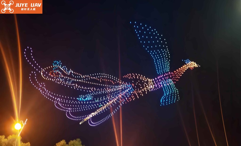
The image above vividly captures the scale and complexity of a modern drone light show, where each luminous point is an RTK-equipped UAV holding its position with centimeter-level fidelity within a vast, dynamic 3D canvas.
3.1 Core Functions Enabled by RTK
Precise 3D Trajectory Following: Show choreography is designed in software, defining the exact 4D path (latitude, longitude, altitude, time) for every drone. RTK provides the real-time feedback necessary for the flight controller to follow this path with extreme precision, enabling smooth, coordinated motion and sharp transitions.
Absolute and Relative Position Holding: For creating static shapes or frames within an animation, drones must hover at exact coordinates. RTK’s low-drift, global coordinate reference allows them to maintain these positions indefinitely, unlike inertial systems that accumulate error over time.
Collision Avoidance Foundation: While dedicated onboard sensors (e.g., UWB, vision) may handle immediate proximity reactions, RTK provides the primary strategic spatial awareness. Knowing each drone’s precise location within a global frame allows the central fleet management software to detect and resolve potential conflicts at the path-planning level before they occur.
Scalability and Repeatability: RTK positioning is independent of swarm size. Adding more drones does not degrade the positioning accuracy of individual units. Furthermore, because movements are defined in precise geographic coordinates, a show can be perfectly repeated on different nights or at different locations.
3.2 System Integration and Workflow
A typical RTK-integrated drone light show system architecture follows this workflow:
- Pre-flight Planning: The show is animated in specialized software (e.g., Disney’s “Flock,” Intel’s “Shooting Star” suite). This generates a precise time-coded sequence of waypoints (W_i) for each drone (D_j):
$$ \text{Show Plan} = \{ \forall D_j, \forall t_k: W_i = (Lat_{i}, Lon_{i}, Alt_{i}, t_{k}) \} $$
- Base Station Setup: One or more RTK base stations are established at known points within or near the flight zone. They begin streaming correction data.
- Swarm Initialization: Drones are powered on. Each acquires GNSS signals, connects to the correction data stream, and resolves its RTK integer ambiguities to achieve a “fixed” centimeter-accurate solution. Their reported positions are checked against their designated “home” or start coordinates in the show plan.
- Show Execution: The central control computer broadcasts time-synchronized movement commands. Each drone’s flight controller uses its real-time RTK position as feedback to navigate to the commanded waypoints. The state vector for control can be simplified as:
$$ \mathbf{u}(t) = K_p \cdot (\mathbf{X}_{cmd}(t) – \mathbf{X}_{RTK}(t)) + K_d \cdot (\mathbf{\dot{X}}_{cmd}(t) – \mathbf{\dot{X}}_{RTK}(t)) $$
where u(t) is the control output, X_RTK is the measured RTK position/velocity, X_cmd is the commanded trajectory, and K_p, K_d are controller gains.
- Real-time Monitoring: The ground control station (GCS) displays the real-time RTK position of every drone on a map. Any deviation beyond a safe threshold (e.g., >0.2m from path) triggers an alert, allowing for manual intervention or automated safety procedures (e.g., hover, return-to-home).
4. Strategic Framework for Ensuring RTK Reliability
Given the critical nature of RTK and its vulnerabilities, a proactive, multi-layered strategy is essential to guarantee the robustness of a drone light show operation.
4.1 Comprehensive Pre-Show Electromagnetic Spectrum Management
This is the first and most crucial line of defense against RFI.
- Site Spectrum Survey: Prior to the event, a thorough spectral scan of the venue and surrounding area should be conducted using professional monitoring equipment. This identifies existing emitters in GNSS frequency bands (e.g., L1: 1575.42 MHz, L2: 1227.60 MHz) and adjacent bands.
- Coordination and Mitigation: Engage with local authorities and spectrum managers to:
- Identify and, if possible, temporarily mitigate potential interference sources (e.g., request nearby radar systems operate in a different mode).
- Formally register the event’s use of spectrum for the RTK data link and command & control, seeking protection from harmful interference.
- Contingency Planning: Develop response protocols for different interference scenarios (e.g., gradual SNR drop vs. complete signal loss). This may involve predefined safe abort maneuvers that do not rely on GNSS.
4.2 Robust System Design and Redundancy
Hardware and software must be designed for resilience.
| System Aspect | Redundancy/Mitigation Strategy | Benefit |
|---|---|---|
| Positioning Source | Dual/multi-constellation RTK (GPS+GLONASS+BeiDou+Galileo). Use of Inertial Measurement Units (IMU) tightly coupled with RTK. | Increases satellite availability and improves geometry. IMU provides short-term navigation during brief GNSS outages, bridging signal gaps. |
| Correction Data Link | Dual-path for corrections (e.g., 4G/5G cellular + local radio link). Use of Network RTK services as a backup to local base stations. | Ensures continuity of corrections if one link fails. NRTK provides wider, more stable coverage. |
| Onboard Avionics | High-quality receivers with advanced multipath mitigation (e.g., survey-grade antennas, choke rings). Proper antenna placement on drone airframe. | Directly improves signal quality and measurement integrity, reducing vulnerability to environmental errors. |
4.3 Operational Protocols and Monitoring
Strict procedures before and during the show are vital.
- Pre-flight Health Check: Verify each drone achieves and maintains a stable RTK “FIX” solution (not the lower-accuracy “FLOAT”) before takeoff. Check baseline length and PDOP values.
- Real-time Integrity Monitoring: The GCS software should continuously monitor key RTK metrics for the entire swarm:
- Solution type (Fixed/Float)
- PDOP/HDOP/VDOP
- Number of satellites tracked
- Correction latency and age.
Automated alerts must be configured for any parameter exceeding safe limits.
- Fail-safe Procedures: Define and test unambiguous actions for loss of RTK. For example: “If >30% of swarm loses RTK FIX for >2 seconds, execute emergency hover using last-known-good-position + IMU, then initiate coordinated landing.”
5. Conclusion and Future Perspectives
RTK technology is the indispensable cornerstone of the modern, large-scale drone light show. It provides the centimeter-accurate, global frame of reference that transforms a collection of individual UAVs into a single, programmable luminous entity capable of executing breathtaking aerial choreography. Its role extends beyond enabling visual spectacle to being the primary guarantor of operational safety in densely packed aerial swarms.
The future evolution of drone light shows will be closely tied to advancements in RTK and related technologies. The integration of Low Earth Orbit (LEO) satellite constellations (e.g., Starlink) for positioning or communication, the development of more robust anti-jamming and spoofing-resistant GNSS receivers, and the maturation of alternative high-precision positioning systems (e.g., terrestrial beacons, celestial navigation) will further enhance reliability. Furthermore, the convergence of RTK with real-time kinematic modeling of the atmosphere and AI-driven anomaly detection in swarm positioning data will push the boundaries of precision and safety.
Ultimately, the successful execution of a drone light show hinges on a deep understanding of RTK’s capabilities and its failure modes. By implementing a holistic strategy encompassing rigorous spectrum management, resilient system design, and strict operational protocols, producers and operators can mitigate risks and ensure that the show not only dazzles the audience but does so with unwavering precision and safety. The continued refinement of these practices will propel the drone light show industry toward ever more ambitious and reliable performances.