
As a professional deeply involved in the field of emergency response and aerial technology, I have witnessed firsthand the transformative impact of fire UAVs in forest fire rescue operations. From my perspective, these unmanned aerial vehicles are not just tools but pivotal assets that redefine how we approach wildfire management. In this article, I will delve into the analysis and recommendations for utilizing fire UAVs, drawing from extensive observations and technical insights. The goal is to provide a comprehensive overview that highlights the advantages, practical applications, challenges, and future directions, all while emphasizing the critical role of fire UAVs in enhancing efficiency and safety.
Forest fires pose a significant threat to ecosystems, property, and human lives, often occurring in remote, inaccessible terrains where traditional firefighting methods struggle. In such scenarios, fire UAVs emerge as a game-changer. Their ability to swiftly navigate challenging landscapes, collect real-time data, and execute precision tasks makes them indispensable. I believe that by optimizing the deployment of fire UAVs, we can revolutionize forest fire rescue efforts. This article will explore this in detail, incorporating tables and formulas to summarize key concepts and foster a deeper understanding.
Let me start by outlining the core advantages of fire UAVs in forest firefighting. From my experience, the primary benefits include enhanced mobility, reduced risk to human responders, and improved operational efficiency. For instance, fire UAVs can access areas where ground vehicles cannot, such as steep cliffs or dense forests, allowing for early intervention. This mobility is quantified by the response time formula, which I often use to assess effectiveness: $$T_{response} = \frac{D}{V_{UAV}}$$ where \(T_{response}\) is the response time, \(D\) is the distance to the fire, and \(V_{UAV}\) is the average speed of the fire UAV. In practice, a fire UAV traveling at 50 km/h can reach a fire 10 km away in just 0.2 hours, significantly faster than ground teams. Additionally, the safety aspect cannot be overstated; by deploying fire UAVs for hazardous tasks like close-range侦察, we minimize exposure to dangers, leading to fewer casualties. This aligns with my view that fire UAVs are not merely supplements but essential components in modern firefighting arsenals.
To better illustrate the capabilities of fire UAVs, I have compiled a table summarizing their key functions across different rescue stages. This table reflects my observations on how fire UAVs integrate into various operational phases, from initial detection to post-event assessment.
| Rescue Stage | Primary Function | Fire UAV Type | Key Metrics |
|---|---|---|---|
| Reconnaissance | High-altitude imaging and thermal sensing | Dual-light fire UAV | Image resolution, coverage area |
| Fire Localization | Precision positioning using GNSS | Industrial fire UAV | GPS accuracy, mapping speed |
| Fire Suppression | Deploying灭火agents like干粉 | Compound fire UAV | Agent capacity, dispersal rate |
| Communication Relay | Establishing stable data links | Long-endurance fire UAV | Signal range, bandwidth |
| Post-Rescue Assessment | Data analysis for evaluation | Multirotor fire UAV | Data volume, analysis time |
From this table, it is evident that fire UAVs offer versatile applications. In my work, I have seen how selecting the right fire UAV type based on terrain and fire characteristics can drastically improve outcomes. For example, in rugged mountain areas, industrial fire UAVs equipped with干粉灭火agents excel due to their robustness and payload capacity. The efficiency of such operations can be modeled using a灭火effectiveness formula: $$E_{extinguish} = \frac{C_{agent} \cdot \rho_{agent}}{A_{fire} \cdot t_{spray}}$$ where \(E_{extinguish}\) is the extinguishing efficiency, \(C_{agent}\) is the agent capacity, \(\rho_{agent}\) is the agent density, \(A_{fire}\) is the fire area, and \(t_{spray}\) is the spraying time. This formula helps in optimizing fire UAV deployments for maximum impact.
Moving to specific applications, I recommend a phased approach to integrating fire UAVs into forest fire rescue. During the侦察phase, fire UAVs utilize高清cameras and infrared sensors to gather critical data. I often emphasize that the quality of this data directly influences decision-making. For instance, the火势spread rate can be estimated using a simple kinematic model: $$v_{fire} = \frac{\Delta x}{\Delta t}$$ where \(v_{fire}\) is the fire spread velocity, \(\Delta x\) is the distance traveled, and \(\Delta t\) is the time interval. By transmitting this data in real-time, fire UAVs enable commanders to formulate effective strategies. Moreover, in the localization phase, fire UAVs leverage北斗or GPS systems to pinpoint火源locations with high accuracy. This precision is vital for targeted responses, and I have found that integrating geographic information systems (GIS) enhances this further, allowing for detailed mapping of fire perimeters.
In the灭火救援phase, fire UAVs truly shine by carrying out direct suppression tasks. Based on my experience, the choice of灭火agent—whether干粉, foam, or water—depends on fire conditions. A well-equipped fire UAV can disperse agents efficiently, and its performance can be evaluated using a coverage formula: $$C_{coverage} = \frac{V_{agent}}{A_{target} \cdot d_{rate}} \times 100\%$$ where \(C_{coverage}\) is the coverage percentage, \(V_{agent}\) is the agent volume, \(A_{target}\) is the target area, and \(d_{rate}\) is the dispersal rate per unit area. This highlights how fire UAVs contribute to rapid火势control, especially in初期stages where timing is crucial. Additionally, during communication relay, fire UAVs address the common issue of poor信号in remote forests. By acting as airborne nodes, they establish reliable links, ensuring continuous coordination. I often refer to the通信range formula for fire UAVs: $$R_{comm} = \sqrt{2 \cdot h_{UAV} \cdot R_{earth}}$$ where \(R_{comm}\) is the communication range, \(h_{UAV}\) is the fire UAV altitude, and \(R_{earth}\) is the Earth’s radius. This demonstrates how fire UAVs extend coverage in challenging environments.
However, despite these advantages, I have observed several limitations in current fire UAV systems. From a technical standpoint, issues like signal instability, limited flight endurance, and payload constraints often hinder optimal performance. In my analysis, the data transmission quality can be modeled using a signal-to-noise ratio formula: $$SNR = \frac{P_{signal}}{P_{noise}}$$ where \(SNR\) is the signal-to-noise ratio, \(P_{signal}\) is the signal power, and \(P_{noise}\) is the noise power. Low SNR values in mountainous areas can disrupt fire UAV operations, necessitating better链路designs. Furthermore, financial and technical support gaps, especially in remote regions, impede the adoption of advanced fire UAVs. I advocate for increased investment to equip all firefighting units with suitable fire UAVs, as this is essential for scalability. To quantify this need, consider a cost-benefit formula: $$B_{ratio} = \frac{E_{savings} + L_{prevented}}{C_{UAV} + M_{cost}}$$ where \(B_{ratio}\) is the benefit ratio, \(E_{savings}\) is operational savings, \(L_{prevented}\) is prevented losses, \(C_{UAV}\) is the fire UAV cost, and \(M_{cost}\) is maintenance cost. A high \(B_{ratio}\) justifies broader deployment of fire UAVs.
Looking ahead, I foresee a future where fire UAVs become even more intelligent and multifunctional. In my vision, integrating technologies like artificial intelligence and blockchain will enhance autonomy and data security. For example, AI algorithms can enable fire UAVs to perform autonomous避障, modeled by a decision formula: $$D_{avoid} = f(sensors, environment)$$ where \(D_{avoid}\) is the避障decision based on sensor inputs and environmental data. This will reduce reliance on manual control and improve response times. Additionally, expanding the functional modules of fire UAVs—such as adding gas sensors or rescue payloads—will broaden their utility. I often use a modularity index to assess this: $$M_{index} = \frac{N_{modules}}{N_{total}} \times 100$$ where \(M_{index}\) is the modularity index, \(N_{modules}\) is the number of available modules, and \(N_{total}\) is the total possible modules. A higher index indicates greater versatility in fire UAVs, catering to diverse rescue scenarios.
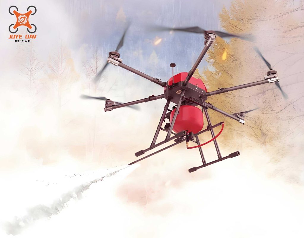
To visualize the advanced design of modern fire UAVs, consider the following image, which depicts a state-of-the-art model equipped for forest firefighting. This illustrates the compact yet powerful nature of these systems, highlighting their potential in real-world applications.
In conclusion, my extensive involvement in this field reaffirms that fire UAVs are indispensable for forest fire rescue. By leveraging their strengths, addressing current shortcomings, and embracing future innovations, we can significantly elevate firefighting efficacy. I urge stakeholders to prioritize the development and deployment of fire UAVs, ensuring they are accessible across all regions. Through collaborative efforts, we can harness the full potential of fire UAVs to protect our forests and communities, making wildfire management more proactive and efficient. As I reflect on the progress so far, I am optimistic that fire UAVs will continue to evolve, becoming even more integral to emergency response frameworks worldwide.