
From my years of experience in both research and practical application, I have witnessed firsthand the transformative impact of Unmanned Aerial Vehicles (UAVs) on agricultural plant protection. The integration of agricultural UAV technology represents a pivotal shift from traditional, labor-intensive methods towards a more precise, efficient, and intelligent paradigm for crop management. The challenge of pest and disease control, a perennial threat to global food security, necessitates continuous innovation. The deployment of agricultural UAV systems directly addresses critical modern agricultural constraints, including rural labor shortages, the need for rapid response to pest outbreaks, and the imperative to reduce the environmental footprint of chemical inputs. This article synthesizes my observations and analysis on the core technological frameworks that empower modern agricultural UAV operations and projects their evolutionary trajectory within the broader ecosystem of smart farming.
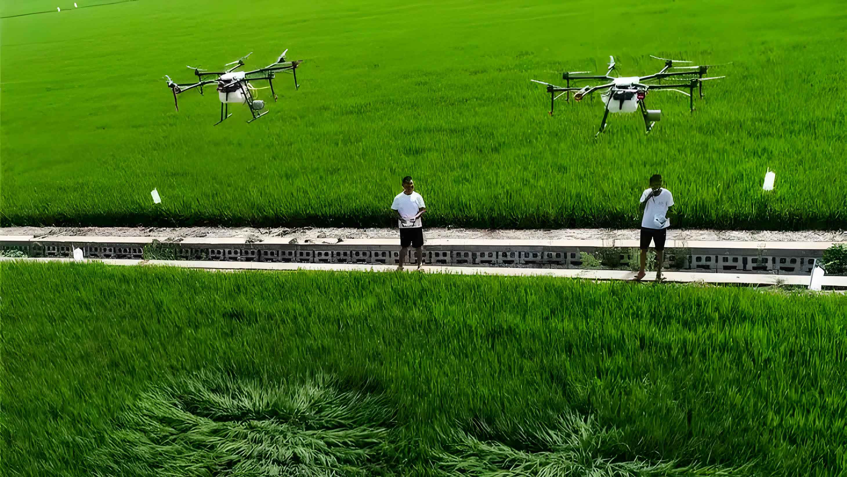
The fundamental advantage of an agricultural UAV lies in its core avionics and positioning systems. Modern platforms are typically equipped with high-precision Global Navigation Satellite Systems (GNSS), such as GPS or BeiDou, and Geographic Information System (GIS) capabilities. This fusion allows for centimeter-level positioning and the execution of pre-programmed flight paths with remarkable repeatability. Unlike ground-based machinery, the agricultural UAV operates in a three-dimensional space, largely unconstrained by challenging terrain like muddy fields, dense crop canopies, or uneven topography. This mobility translates directly into operational advantages: significant savings in water and chemical carrier volumes (often over 90% compared to conventional boom sprayers), drastically reduced application time per unit area, and the ability to conduct operations during critical, narrow windows of opportunity. As a researcher and practitioner, I see the agricultural UAV not merely as a spraying tool, but as a versatile, flying sensor and actuator platform that is becoming the cornerstone of precision agriculture.
However, the mere ability to fly and spray is insufficient. The true value and efficacy of an agricultural UAV are unlocked through a suite of advanced application technologies. These technologies aim to optimize the deposition of pesticidal droplets onto the intended biological target (the crop canopy) while minimizing losses to non-target areas—a concept central to both economic and environmental sustainability.
Core Technological Pillars of Modern Agricultural UAVs
The evolution of the agricultural UAV has been driven by advancements in several interdependent technological domains. Below, I detail what I consider the most critical areas from an application efficacy standpoint.
1. Variable-Rate Application (VRA) Technology
The principle of “apply only where needed, and only as much as needed” is the holy grail of precision agriculture. Variable-rate application technology enables the agricultural UAV to modulate its output in real-time based on georeferenced data, moving beyond uniform blanket spraying. The dominant technical approach utilizes Pulse-Width Modulation (PWM) to control the pump or solenoid valves governing liquid flow.
The core mechanism involves rapidly switching the power to the pump or valve on and off. The proportion of time the signal is “on” within a fixed period is the duty cycle ($D$). The average voltage ($V_{avg}$) supplied, and consequently the pump’s rotational speed or valve open time, is directly proportional to this duty cycle and the supply voltage ($V_s$):
$$ V_{avg} = D \cdot V_s $$
Therefore, by varying $D$ via a software-controlled signal from the flight controller, the system can precisely regulate the flow rate ($Q$) from the spray system. A simplified relationship can be expressed as:
$$ Q = k \cdot D \cdot f(P) $$
where $k$ is a system constant and $f(P)$ is a function accounting for pump characteristics and system pressure. This allows the agricultural UAV to automatically increase or decrease output when flying over areas of high or low pest pressure, as defined by a prescription map. More advanced systems integrate real-time sensors, such as multispectral cameras, to generate “on-the-go” prescription maps for dynamic, sensor-based VRA.
| VRA Implementation Method | Key Technology | Data Source | Advantages | Current Challenges |
|---|---|---|---|---|
| Map-Based VRA | PWM Control, GIS Integration | Pre-existing scouting maps, soil/ yield history | Predictable, efficient for known variability | Relies on accurate, timely prior data |
| Sensor-Based VRA | Real-time optical/spectral sensors, edge computing | Live canopy reflectance (NDVI, NDRE) | Responsive to actual crop conditions | Higher cost, complex data processing, algorithm robustness |
| AI-Powered VRA | Machine Learning, Computer Vision | Real-time video/image streams | Potential for direct pest/disease identification and spot-spraying | Immature technology, requires vast training datasets |
2. Autonomous Obstacle Avoidance Technology
The operational environment for an agricultural UAV is fraught with static and dynamic obstacles: trees, power lines, poles, and even humans or animals. Reliable autonomous obstacle avoidance is no longer a luxury but a necessity for safe and scalable operation. This technology hinges on robust perception systems and intelligent flight control algorithms.
Common sensor modalities include:
- Visual Stereo Vision: Uses two cameras to estimate depth. Effective in good light but computationally intensive.
- LiDAR (Light Detection and Ranging): Emits laser pulses to measure distance. Highly accurate for range and shape detection but expensive and sensitive to dust/moisture.
- Ultrasonic Sensors: Low-cost and effective for short-range detection, often used for terrain following.
- Millimeter-Wave Radar: Penetrates dust, light rain, and fog, providing reliable data in poor visibility.
The core decision-making process often involves creating a local occupancy grid or point cloud of the environment. The flight controller then executes a path-planning algorithm (e.g., A*, RRT) to compute a collision-free trajectory. A simplified representation of a potential field algorithm, which repels the UAV from obstacles, can be conceptualized. The total repulsive force ($\vec{F}_{rep}$) from nearby obstacles and attractive force ($\vec{F}_{att}$) toward the waypoint guide the UAV:
$$ \vec{F}_{total} = \vec{F}_{att} + \sum \vec{F}_{rep} $$
Where the repulsive force from a single obstacle increases inversely with the square of the distance ($d$) to it, up to a threshold distance ($d_0$):
$$
\vec{F}_{rep} = \begin{cases}
\eta \left(\frac{1}{d} – \frac{1}{d_0}\right) \frac{1}{d^2} \hat{d} & \text{if } d \le d_0 \\
0 & \text{if } d > d_0
\end{cases}
$$
Here, $\eta$ is a scaling constant, and $\hat{d}$ is the unit vector pointing from the obstacle to the UAV. This ensures the agricultural UAV smoothly navigates around obstacles while progressing toward its mission objective.
3. Drift Reduction Technology
Spray drift—the movement of pesticide droplets away from the target area—is the primary cause of inefficiency and environmental contamination in aerial application. For an agricultural UAV operating just 1-3 meters above the canopy, mitigating drift is paramount. The physics of drift is governed by the interaction between droplet aerodynamics and ambient conditions. The terminal velocity ($v_t$) of a droplet in still air, a key factor in its settling speed, is given by Stokes’ law for small droplets:
$$ v_t = \frac{2}{9} \frac{(\rho_d – \rho_a) g r^2}{\mu} $$
where $\rho_d$ and $\rho_a$ are droplet and air density, $g$ is gravity, $r$ is droplet radius, and $\mu$ is air viscosity. This shows that droplet size ($r$) is critically important; smaller droplets have a much lower $v_t$ and are far more susceptible to being carried away by wind. Therefore, drift management for the agricultural UAV is a multi-faceted strategy targeting droplet spectrum, formulation, and operational practice.
| Drift Reduction Strategy | Mechanism | Typical Implementation on Agricultural UAV | Impact on Droplet Spectrum (DV50)* |
|---|---|---|---|
| Nozzle Technology | Generates larger, more uniform droplets with higher kinetic energy. | Anti-drift (AD) nozzles, air-induction (AI) nozzles, rotary atomizers. | Increases DV50 from ~150 µm to ~300-500 µm. |
| Spray Formulation Adjuvants | Alters physicochemical properties (viscosity, surface tension). | Tank-mixing deposition aids, drift retardants, humectants. | Can increase DV50 and reduce fine droplet proportion. |
| Operational Parameters | Optimizes flight path relative to environmental factors. | Flying at lower altitudes, avoiding application in high winds, establishing buffer zones. | Minimizes exposure time of droplets to adverse wind conditions. |
| Vortex & Downwash Management | Utilizes rotor downwash to enhance droplet penetration and deposition. | Optimizing UAV frame design, rotor speed, and flight speed to control downwash airflow. | Improves canopy penetration but requires careful management to avoid droplet shattering. |
* DV50: Volume Median Diameter, the droplet diameter where 50% of the spray volume is comprised of smaller droplets.
Furthermore, predictive drift modeling software (e.g., AGDISP, AgDRIFT) is increasingly integrated into mission planning software for agricultural UAV operators. These models use inputs like nozzle type, droplet data, weather forecasts, and UAV parameters to predict drift potential and recommend safe buffer distances.
4. Droplet Deposition Assessment and Quality Control
Verifying the quality and uniformity of the application is essential for ensuring efficacy and justifying the use of the agricultural UAV. Traditional methods involve placing water-sensitive or oil-sensitive papers throughout the field and manually counting droplets—a tedious and post-application process. Modern techniques strive for real-time or rapid assessment.
One advanced method involves laser-based scanning. A LiDAR or laser diffraction sensor can be used to sample the spray cloud beneath the agricultural UAV. The scattering or attenuation of the laser beam by droplets can be correlated to droplet density and size distribution in near-real-time. The basic principle of light attenuation follows the Beer-Lambert law:
$$ I = I_0 e^{- \sigma n x} $$
where $I$ is the transmitted laser intensity, $I_0$ is the initial intensity, $\sigma$ is the extinction cross-section of a droplet (related to its size), $n$ is the number density of droplets, and $x$ is the path length through the cloud. By measuring $I$, one can infer information about the spray cloud’s characteristics. Another promising area is thermal imaging, where the evaporative cooling effect of droplets on a surface creates a thermal signature that can be rapidly analyzed to map deposition density.
For assessing effective swath width, the “50% Effective Deposition Method” is often more reliable than simple droplet density counts. It involves measuring deposition across the swath and identifying the width where the deposition rate falls to 50% of the maximum rate measured directly under the flight line. This accounts for the overlapping of swaths in practice and provides a more pragmatic operational parameter for the agricultural UAV pilot.
Future Trajectories and Synergistic Developments
Based on the current technological trajectory and market demands, I anticipate the evolution of the agricultural UAV will be shaped by several key trends that move beyond incremental improvements in spraying alone.
1. Integration with Intelligent Mobile Operation Platforms: The future agricultural UAV will be a node in a connected farm network. We are moving towards seamless operation via intuitive smartphone or tablet applications that offer more than basic flight control. These platforms will feature AI-assisted mission planning (automatically dividing complex fields into optimal flight paths), real-time fleet management for multiple UAVs, integrated weather and drift risk alerts, and direct data sync with farm management software (FMS). This turns the mobile device into a universal command center, lowering the barrier to entry and enhancing decision-support for the operator.
2. Pursuit of Greater Payload and Endurance: While multi-rotor agricultural UAV models dominate due to their precision and agility, their payload (typically 10-40 kg) and flight time (10-25 minutes) limit efficiency on large, contiguous fields. The trend is toward hybrid vertical take-off and landing (VTOL) fixed-wing designs and larger multi-rotor platforms. These hybrids combine the take-off and landing flexibility of rotors with the efficient, forward flight of a fixed-wing, dramatically extending endurance to over an hour and payload capacity. The development of higher energy-density batteries and the exploration of hybrid gas-electric powertrains are critical enablers for this evolution. The relationship between endurance ($E$), battery capacity ($C$), and power draw ($P$) is fundamental:
$$ E \propto \frac{C}{P} $$
Innovations that increase $C$ (better batteries) or decrease $P$ (more efficient aerodynamics and powertrains) directly translate to longer operational time for the agricultural UAV.
3. Evolution into a Multi-Function Phenotyping and Analysis Platform: The most significant shift will be from viewing the agricultural UAV solely as a sprayer to recognizing it as an essential data acquisition tool. Future platforms will be modular, allowing easy swapping of payloads between spraying systems, high-resolution multispectral/hyperspectral cameras, LiDAR scanners, and other sensors. This enables the same agricultural UAV to conduct crop health monitoring, biomass estimation, moisture stress detection, and yield prediction throughout the season. The data collected feeds into predictive analytics models, which in turn generate the precise prescription maps that guide the UAV’s spraying activities, creating a closed-loop, data-driven crop management system.
4. Regulatory and Environmental Harmonization: The future will demand tighter integration of application technology with environmental stewardship. This includes the development and adoption of “green” spray formulas specifically optimized for agricultural UAV low-volume application, further refinement of buffer zone prediction models backed by empirical data, and the integration of application records with blockchain or other traceability systems for full supply chain transparency. Regulatory frameworks will evolve to standardize testing and certification of agricultural UAV application systems, much like they do for ground sprayers today.
Concluding Synthesis
The journey of the agricultural UAV from a novel concept to a mainstream farming tool has been accelerated by convergence in robotics, sensing, and data science. The key technologies discussed—variable-rate application, autonomous obstacle avoidance, drift reduction, and deposition assessment—are not isolated components but interconnected layers of a sophisticated application system. As we look forward, the trajectory points towards greater autonomy, intelligence, and integration. The agricultural UAV will become less of a standalone piece of equipment and more of an intelligent agent within a broader digital agriculture ecosystem. Its success will ultimately be measured not just by hectares covered per hour, but by its contribution to a more sustainable, resilient, and productive agricultural system—one where inputs are minimized, crop health is maximized, and environmental impact is carefully managed. The continued refinement of these technologies and the thoughtful exploration of their synergies will determine how fully the potential of the agricultural UAV is realized in the fields of the future.