
The escalating threat of catastrophic wildfires, driven by climate change and anthropogenic pressures, necessitates a paradigm shift in forest fire management strategies. Conventional methods of fire detection, monitoring, and suppression often fall short in the face of rapidly evolving, large-scale fire events occurring in complex, inaccessible terrains. In this context, Unmanned Aerial Vehicles (UAVs), or drones, have emerged as a transformative technology. This article provides a comprehensive, first-person review of the application of fire UAV systems in forest fire management. It delves into their technological foundations, operational capabilities across the wildfire management cycle, inherent limitations, and future trajectories, arguing for their indispensable role in building more resilient and adaptive fire management systems.
The fundamental appeal of fire UAV technology lies in its unique operational characteristics. These are robotic aircraft systems capable of performing missions without an onboard human pilot, controlled remotely or via pre-programmed flight plans. A typical fire UAV system comprises the airframe (the drone itself), a ground control station (GCS) for command and data reception, a communication datalink, and a suite of payload sensors. Their key advantages for forestry applications include operational flexibility, the ability to access hazardous or remote areas without risking human life, relatively low acquisition and operational costs compared to manned aircraft, and the capacity for persistent, high-resolution data collection.
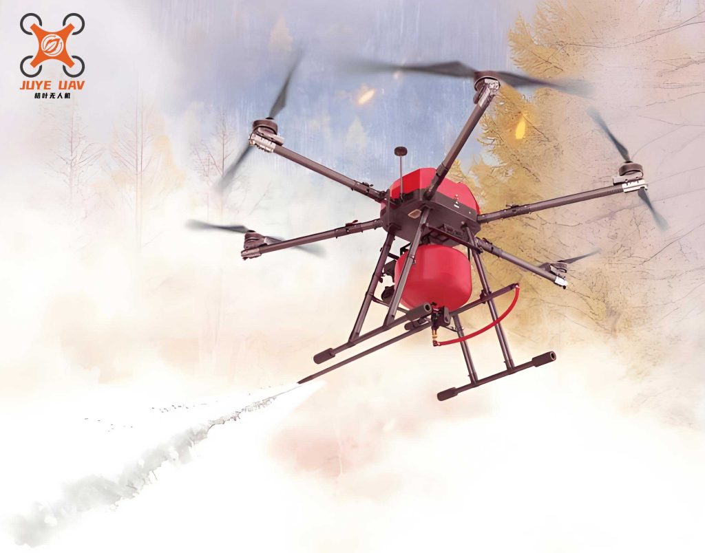
Fire UAV platforms can be broadly categorized based on their aerodynamic design, which dictates their capabilities. The primary classifications and their typical specifications for fire missions are summarized below:
| Platform Type | Key Features | Typical Endurance | Typical Payload Capacity | Primary Fire Mission Role |
|---|---|---|---|---|
| Fixed-Wing UAV | Wing-generated lift; Efficient for long-range, large-area coverage. | 2 – 20+ hours | 1 – 20 kg | Broad-area pre-fire scanning, post-fire damage assessment, long-distance logistics. |
| Multi-Rotor UAV (Quadcopter, Hexacopter, Octocopter) | Vertical Take-Off and Landing (VTOL); High maneuverability and hover capability. | 20 mins – 1.5 hours | 0.5 – 10 kg | Tactical firefront monitoring, structure inspections, spot fire detection, payload delivery (e.g., retardant). |
| Hybrid VTOL UAV | Combines VTOL capability of rotors with efficient forward flight of fixed wings. | 1 – 4 hours | 2 – 8 kg | Versatile missions requiring both long transit and precise station-keeping over a target. |
The operational efficacy of a fire UAV is fundamentally determined by its sensor payload. The integration of multi-spectral and thermal sensors has been particularly revolutionary. Visible-spectrum cameras provide high-resolution context, while specialized sensors unlock critical fire data. The energy radiated by a fire front, a key parameter for behavior modeling, can be related to sensor readings. For instance, the radiant heat flux ($Q_{rad}$) detected by a thermal sensor can be linked to the fire’s intensity. A simplified representation of the relationship between observed pixel temperature and energy is often derived from the Stefan-Boltzmann law:
$$ Q_{rad} = \epsilon \sigma T_{pixel}^4 $$
where $\epsilon$ is the emissivity of the flame/embers, $\sigma$ is the Stefan-Boltzmann constant ($5.67 \times 10^{-8} \, W m^{-2} K^{-4}$), and $T_{pixel}$ is the absolute temperature measured for a pixel in the thermal image.
| Sensor Type | Spectral Bands | Key Fire Management Applications |
|---|---|---|
| Visible (RGB) Camera | Red, Green, Blue | High-resolution mapping, visual confirmation of smoke/ignition, documentation, terrain assessment. |
| Thermal Infrared (TIR) Camera | Long-Wave Infrared (LWIR, 8-14 µm) | Active fire detection through smoke, night operations, hotspot identification, post-fire mop-up (finding residual heat). |
| Multispectral Sensor | Discrete bands (e.g., Red Edge, NIR) | Vegetation health analysis (pre-fire fuel moisture stress), burn severity assessment (dNBR calculation). |
| Hyperspectral Sensor | Hundreds of contiguous narrow bands | Detailed fuel type classification, chemical detection in smoke, advanced post-fire ecology studies. |
| LiDAR (Light Detection and Ranging) | Laser pulses | High-precision 3D terrain and fuel structure modeling, canopy height and density, fuel layer continuity analysis. |
The application of fire UAV technology spans the entire continuum of wildfire management: pre-fire preparedness, active fire response, and post-fire recovery.
1. Pre-Fire Preparedness and Fuel Assessment
In the pre-ignition phase, fire UAV systems are powerful tools for risk mitigation. By conducting systematic aerial surveys, they enable the creation of high-resolution, three-dimensional fuel maps. LiDAR-equipped drones can quantify critical fuel parameters such as canopy bulk density, canopy base height, and ground fuel load with unprecedented spatial detail. This data directly feeds into sophisticated fire behavior prediction models like FARSITE or Prometheus, significantly improving their accuracy. The rate of spread ($R$) in many models is a function of fuel, weather, and topography:
$$ R = R_0 \cdot (1 + \phi_w + \phi_s) $$
where $R_0$ is the spread rate under standard conditions for a specific fuel type, and $\phi_w$ and $\phi_s$ are wind and slope correction factors, respectively. Accurate fuel mapping via fire UAV refines the $R_0$ input. Furthermore, multispectral data can be processed to derive indices like the Normalized Difference Moisture Index (NDMI), which correlates with live fuel moisture content—a critical variable for ignition potential and fire intensity.
2. Active Fire Detection, Monitoring, and Intelligence
This is the most prominent and life-saving application. Fire UAV systems provide a persistent “eye in the sky” over an incident. Their roles are multifaceted:
- Early Detection and Confirmation: Patrolling high-risk areas, a fire UAV equipped with visual and thermal cameras can detect nascent smokes or hotspots long before they are visible from ground towers, especially in deep valleys or rugged terrain, enabling a “golden hour” response.
- Real-Time Situational Awareness: They relay live video and thermal imagery to the Incident Command Post, showing the exact location of the fire perimeter, spotting activity, and head fire intensity. This allows for dynamic, evidence-based resource deployment and tactical adjustment.
- Specialized Fire Behavior Analysis: Fire UAV are uniquely positioned to safely study dangerous fire phenomena. By circling a convection column, they can measure its vertical velocity profile and temperature gradients. Tracking the trajectory and landing distribution of firebrands (spot fires) provides data to model the probability of spot fire ignition ($P_{ignition}$) as a function of brand properties and receptive fuel characteristics.
For example, the Byram’s fireline intensity ($I_B$) can be conceptually linked to observable plume dynamics:
$$ I_B = H \cdot w \cdot r $$
where $H$ is the heat yield of the fuel ($kJ/kg$), $w$ is the weight of fuel consumed per unit area ($kg/m^2$), and $r$ is the rate of spread ($m/s$). A fire UAV observing a strong, well-developed convection column infers a high $I_B$.
3. Direct and Indirect Suppression Support
Beyond intelligence, fire UAV are evolving into active suppression tools. Heavy-lift multi-rotor platforms can execute precision drops of fire retardant, water, or suppressant gels on specific hotspots or to reinforce control lines, a task too dangerous for low-flying manned aircraft in turbulent fire environments. They can also deploy delayed ignition devices (Drones for Aerial Ignition) for backburning operations with pinpoint accuracy, a method far safer and more controlled than ground-based or helicopter-mounted ignition. Furthermore, they guide ground crews by identifying safe anchor points, optimal line construction paths, and potential safety zones, directly enhancing firefighter safety.
4. Post-Fire Assessment and Rehabilitation
After containment, fire UAV systems conduct rapid and comprehensive damage assessments. Multispectral sensors are used to compute the Differenced Normalized Burn Ratio (dNBR), a key metric for burn severity:
$$ dNBR = NBR_{prefire} – NBR_{postfire} $$
where $NBR = (NIR – SWIR) / (NIR + SWIR)$. High-resolution dNBR maps from fire UAV delineate areas of high, moderate, and low soil and vegetation impact, guiding rehabilitation efforts like seeding or erosion control. Thermal cameras are flown at dawn to identify lingering hotspots requiring mop-up, ensuring the fire is truly extinguished. Long-term, repeat flights monitor ecosystem recovery, track invasive species colonization, and assess the effectiveness of restoration treatments.
Despite their transformative potential, the widespread operational deployment of fire UAV systems faces significant challenges.
| Challenge Category | Specific Limitations | Impact on Operations |
|---|---|---|
| Technical & Environmental | Limited flight endurance (especially for multi-rotors); Payload-weight constraints; Vulnerability to extreme fire-induced weather (high winds, turbulence, intense heat, smoke particulate interference). | Restricts on-station time and sensor options; Can lead to mission abort or loss of vehicle in severe fire behavior conditions (e.g., near fire whirls or thick convection columns). |
| Data Management & Integration | High volume of real-time data; Need for rapid processing/analysis; Integration of UAV-derived data with other systems (GIS, fire models) in a usable format for command staff. | Can create data overload; Delays in turning imagery into actionable intelligence if processing is not automated and streamlined. |
| Regulatory & Airspace | Complex airspace regulations, especially in areas with manned aircraft (air tankers, helicopters); Requirement for licensed pilots and specific operational approvals (e.g., Beyond Visual Line of Sight – BVLOS). | Can delay launch or restrict flight areas, complicating coordination in busy fire airspace and limiting scalability. |
| Cost & Logistics | Initial investment for advanced systems; Need for trained personnel, maintenance, and transportation; Deployment logistics to remote fire camps. | May be prohibitive for smaller agencies; Requires dedicated personnel and support infrastructure. |
The future of fire UAV in forest fire management hinges on overcoming these limitations through technological and operational innovation.
1. Technological Advancements: Research is focused on improving energy density in batteries or hybrid propulsion to extend endurance. Developments in materials science will enable lighter, more heat-resistant airframes. The miniaturization and increased performance of sensors, particularly hyperspectral and LiDAR, will become more accessible. Perhaps most critically, advancements in artificial intelligence (AI) and machine learning (ML) are poised to revolutionize fire UAV operations. Onboard AI will enable real-time, automated fire detection and perimeter tracking, predictive analysis of fire spread, and intelligent, adaptive flight path planning to avoid hazards and optimize data collection.
2. Swarm and Collaborative Systems: The concept of deploying coordinated swarms of heterogeneous fire UAV is a key frontier. A swarm could involve long-endurance fixed-wing drones for wide-area scanning, communicating with agile multi-rotors that dive in for detailed inspection of detected hotspots. This collaborative system would provide seamless, multi-scale awareness. Furthermore, integration between fire UAV and other autonomous systems, such as unmanned ground vehicles (UGVs) for line construction or logistics, will create a cohesive robotic force for firefighting.
3. Enhanced Autonomy and BVLOS Operations: The move towards higher levels of autonomy (from automated flight to fully cognitive decision-making) and the regulatory approval for routine BVLOS flights are essential for scaling up fire UAV use. This will allow single operators to manage multiple drones over vast, remote areas, making persistent surveillance a cost-effective reality.
4. Standardization and Interoperability: Developing standard data protocols, communication links, and operational procedures is crucial. A fire UAV from one agency must be able to seamlessly share data and integrate into the command structure of a large, inter-agency incident. Cloud-based common operating picture platforms that can ingest and visualize real-time fire UAV data alongside satellite feeds and ground reports will be central to this integration.
In conclusion, fire UAV technology has rapidly evolved from a novel reconnaissance tool to a cornerstone of modern, intelligence-driven wildfire management. Their ability to provide safe, persistent, and high-resolution data across the prevention, response, and recovery cycle is unmatched. While challenges related to endurance, regulation, and data integration persist, ongoing advancements in AI, swarm robotics, and vehicle design are steadily overcoming these hurdles. The future points towards an integrated ecosystem where manned assets, satellite networks, and autonomous fire UAV systems—both aerial and ground-based—operate synergistically. This technological fusion promises not only to enhance operational effectiveness and firefighter safety but also to deepen our scientific understanding of fire behavior, ultimately leading to more resilient forests and communities in an era of increasing fire risk.