
As a researcher and practitioner in the field of emergency response technology, I have witnessed firsthand the transformative impact of unmanned aerial vehicles on operational efficacy. Among these advancements, the integration of drone technology into fire and rescue communications stands out as a paradigm shift. The modern fire drone is no longer a mere flying camera; it has evolved into a sophisticated, multi-role communication and data acquisition platform. This article delves into the technical foundations, practical applications, and systemic integration of fire drone technology, with a particular focus on its role in creating a robust, real-time communication network for disaster management. The primary objective is to provide a comprehensive, first-person perspective on how these systems are engineered, deployed, and leveraged to save lives and property.
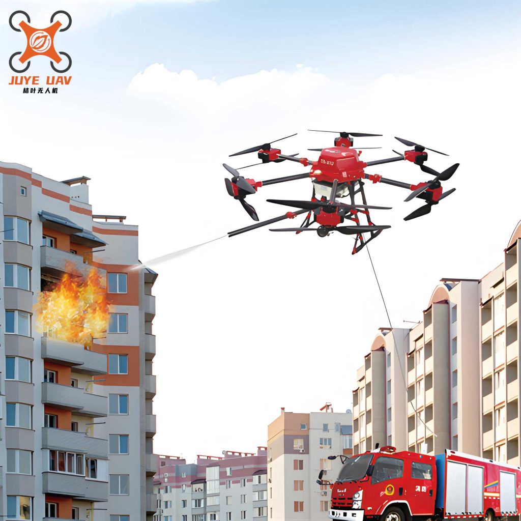
The core advantage of the fire drone in emergency communications stems from its unique operational profile. Traditional communication relays are limited by terrain, infrastructure damage, and safety concerns for personnel. A fire drone, by contrast, offers an unparalleled combination of mobility, perspective, and resilience. It can be rapidly deployed to establish a temporary, airborne network node, providing line-of-sight connectivity where none existed. This capability is critical in the initial chaotic minutes of a major incident, where information is scarce and the situation is fluid. From my analysis, the benefits can be systematically categorized as shown in the table below, comparing traditional limitations with fire drone-enabled solutions.
| Communication Challenge | Traditional Limitation | Fire Drone-Enabled Solution |
|---|---|---|
| Initial Reconnaissance & Situational Awareness | Relies on ground reports and fixed cameras; slow, incomplete, and often dangerous to obtain. | Provides immediate, high-altitude, 360-degree visual and thermal assessment before ground teams are fully deployed. |
| Communication Relay in Obstructed Terrain | Radio signals blocked by high-rise buildings, mountains, or underground structures; creating deadly “dead zones.” | Acts as an aerial repeater, bypassing obstructions to maintain seamless voice and data links between incident command and interior teams. |
| Real-Time Dynamic Monitoring | Static command views; difficult to track the spread of fire, collapse zones, or movement of personnel in real-time. | Offers persistent surveillance, streaming live data that allows command to adapt tactics to the evolving incident. |
| Safety for Communication Personnel | Technicians often need to enter hazardous zones to deploy equipment, risking injury. | Deploys and positions communication payloads from a safe distance, keeping personnel out of immediate danger. |
Technical Architecture and Core Functions of the Fire Drone Platform
The effectiveness of a fire drone in a communication role is dictated by its integrated systems. A typical platform, such as the hexacopter mentioned in the source material, is built for stability, payload capacity, and endurance. The airframe, often using composite materials like carbon fiber, provides the necessary strength-to-weight ratio. The true power, however, lies in the synergistic payload suite. The communication-centric fire drone is equipped with a multi-sensor array and a robust data link system.
1. Advanced Reconnaissance and Pathfinding: The primary function is intelligence gathering. This goes beyond simple video. Modern fire drone systems employ:
- Visible Spectrum HD Cameras: For general scene assessment and documentation.
- Thermal Imaging Cameras: Critical for seeing through smoke, identifying hotspots, and locating victims based on body heat signatures. The temperature data can be used to generate a real-time thermal map of the incident area.
- LiDAR or Multispectral Sensors: For creating detailed 3D maps of structural integrity or assessing chemical spills.
To optimize flight paths for maximum coverage in minimum time, autonomous navigation algorithms are essential. A common approach synthesizes path planning techniques. For instance, an optimized path P for a fire drone covering a disaster zone Z can be modeled by combining search and swarm intelligence algorithms. The A* algorithm finds the shortest path, while adaptations of the Ant Colony Optimization (ACO) algorithm can optimize for area coverage. The cost function for a path segment might consider distance, obstacle density, and information gain:
$$ C_{segment} = \alpha \cdot d + \beta \cdot O_{density} – \gamma \cdot I_{gain} $$
where d is distance, Odensity is local obstacle density, Igain is the estimated information value of the area, and α, β, γ are weighting coefficients tuned for fireground operations.
2. Multi-Modal Data Transmission: The captured data is useless if it cannot be reliably transmitted. Therefore, a fire drone functions as a hybrid communication node. It typically employs a dual or triple-link system for redundancy:
- High-Bandwidth Direct Link (e.g., COFDM/Microwave): Provides low-latency, high-definition video feed directly to a nearby command vehicle or ground station. This link is crucial for real-time tactical decisions.
- Cellular Network Link (4G/5G): Leverages public networks to backhaul data to cloud servers or remote command centers. This provides wider accessibility for stakeholders not at the immediate scene.
- Secure Mesh Radio Link: Integrates with the incident’s land mobile radio (LMR) system, allowing the fire drone to act as a repeater, extending the range and penetration of voice communications for firefighters inside structures.
The choice of transmission mode involves a classic trade-off analyzed by the Shannon-Hartley theorem, which defines the channel capacity C:
$$ C = B \cdot \log_2(1 + \frac{S}{N}) $$
where B is bandwidth, S is signal power, and N is noise power. The fire drone‘s altitude advantage directly increases the line-of-sight range and often the signal-to-noise ratio (S/N) for its links compared to ground-based units, thereby increasing effective channel capacity for vital data.
| Transmission Mode | Typical Bandwidth/Latency | Primary Use Case | Pros & Cons |
|---|---|---|---|
| Direct RF (COFDM) | High BW, Very Low Latency (<200ms) | Real-time piloting, tactical live video for on-scene command. | Pro: Reliable, secure, independent of infrastructure. Con: Limited range (typically 5-10 km). |
| Public 4G/5G | High BW, Medium Latency (50ms-1s) | Backhauling video to remote experts, cloud-based analytics, off-site command. | Pro: Long-range, leverages existing infrastructure. Con: Dependent on network availability/congestion; potential security concerns. |
| LMR Repeater Mode | Low BW (Voice), Low Latency | Extending and bridging voice communication between interior teams and command. | Pro: Life-critical, integrates with existing fireground radios. Con: Voice only, requires specific integration. |
3. Auxiliary Communication Functions: Beyond data relay, the fire drone serves as an active broadcast node. Mounting a powerful loudspeaker allows incident commanders to deliver clear instructions to crowds or trapped individuals from an optimal aerial position, overcoming ground-level noise. Similarly, integrating high-intensity strobes or laser pointers can provide visual signals for coordinating ground teams or marking locations.
Systemic Integration: The Fire Drone in the Communication Network
A fire drone does not operate in isolation. Its maximum value is realized when integrated into a broader Incident Command System (ICS) communication architecture. This integration involves both technology and standardized protocols.
From a network topology perspective, the fire drone becomes a dynamic node. In a major incident, multiple fire drone units could be deployed, forming a temporary airborne mesh network or a star network centered on a command vehicle. This architecture ensures redundancy; if one fire drone fails or moves, others can maintain network coverage. The diagram below conceptualizes this integration, showing how the fire drone bridges gaps between various operational elements.
The operational workflow can be formalized. Let D represent the set of deployed fire drone units, G represent ground teams, C represent command nodes, and L(di, dj) represent a stable communication link between two nodes. The goal of the deployment strategy is to maximize total connectivity Φ across the operational area A over the mission time T:
$$ \max \Phi = \int_{t=0}^{T} \int_{A} \sum_{d_i, d_j \in D \cup G \cup C} \mathbb{1}_{L(d_i, d_j, t)} \, da \, dt $$
where $\mathbb{1}_{L}$ is an indicator function equal to 1 if a stable link exists at time t. This model highlights the dynamic, coverage-maximizing role of the fire drone swarm.
Standardized protocols are equally important. Data from the fire drone‘s sensors must be ingested into common operational picture (COP) software used by command staff. This requires interoperability standards for video streaming (e.g., RTSP), geospatial data (e.g., KML), and telemetry. Furthermore, clear protocols must govern who controls the fire drone‘s flight path (the pilot), who controls its sensors (a dedicated operator or incident commander), and who is responsible for interpreting and acting on the data stream.
| Incident Phase | Primary Fire Drone Role | Key Communication Function | Data Products Generated |
|---|---|---|---|
| Phase 1: Response & En Route | Advanced Scout | Initial situational report via cellular/radio link to responding units and command. | Live video feed, geotagged photos, estimated scale of incident. |
| Phase 2: Initial Attack & Size-Up | Aerial Command Post & Relay | Establishing primary direct video link to command vehicle; extending LMR coverage for first-in crews. | Thermal overview map, identification of primary hazards and access points. |
| Phase 3: Extended Operations | Persistent Surveillance & Network Node | Monitoring fire progression/structural stability; maintaining communication links for interior teams during rotation. | Time-lapse video for tracking progress, continuous thermal monitoring data. |
| Phase 4: Overhaul & Investigation | Forensic Documentation | High-resolution mapping and data collection for post-incident analysis. | Orthomosaic maps, 3D models, comprehensive visual record. |
Case Analysis: High-Rise Fire Scenario
To crystallize these concepts, consider a complex high-rise fire scenario. Upon dispatch, the first-responding chief officer authorizes the launch of a long-endurance fire drone from a nearby staging area. While en route, the crew receives the fire drone‘s live feed on a tablet, confirming the fire location on the 15th floor with visible smoke from two sides—critical intelligence that alters initial resource deployment.
On arrival, the fire drone pilot establishes a direct video downlink to the incident command post. Simultaneously, the fire drone‘s payload operator switches to thermal imaging, identifying the seat of the fire and, crucially, several heat signatures on the floor above that indicate trapped occupants. This information is immediately relayed via radio to the interior search and rescue teams, directing them precisely. Meanwhile, the incident commander uses the loudspeaker function to broadcast messages to visible occupants on unaffected floors, instructing them to stay put and signal from windows.
As interior teams advance, they report radio signal degradation in the central core of the building. The incident commander directs the fire drone pilot to position the aircraft close to the fire floor on the opposite side of the building from the ladder pipes. The fire drone, with its integrated LMR repeater payload, is now optimally positioned to bridge the communication gap. Its altitude provides the line-of-sight needed to connect the deep interior teams with the exterior command, restoring clear and reliable voice communications—a direct and potentially life-saving application of the fire drone as a communication asset.
The entire operation is documented by the fire drone‘s recording systems, providing an invaluable asset for the subsequent after-action review and tactical analysis.
Future Trajectories and Concluding Synthesis
The evolution of the fire drone as a communication nexus is ongoing. Future developments point towards increased autonomy, enhanced interoperability, and more sophisticated payloads. Swarm technology, where multiple fire drone units collaborate autonomously to provide continuous communication coverage and sensor coverage over a vast area, is on the horizon. Integration with artificial intelligence for real-time data analysis—such as automatic fire spread prediction or victim detection in thermal feeds—will further accelerate decision-making cycles. Furthermore, the development of standardized “communication pod” payloads that can be quickly swapped onto different fire drone platforms will increase flexibility and adoption.
However, these technological advances must be matched by robust training, clear doctrine, and secure, resilient communication protocols. The fire drone is a tool, and its power must be wielded by skilled professionals within a well-defined operational framework.
In conclusion, from my perspective, the integration of drone technology into fire service communications represents one of the most significant advancements in recent emergency response history. The modern fire drone transcends its origins as a reconnaissance tool to become an intelligent, mobile communication hub. It provides the eyes, ears, and voice for command in environments where human senses fail and traditional systems break down. By establishing early situational awareness, maintaining critical communication links, and delivering actionable intelligence in real-time, the fire drone dramatically enhances operational safety, coordination, and effectiveness. As this technology continues to mature and become more deeply woven into the fabric of incident command systems, its role as an indispensable guardian of both public and responder safety will only become more profoundly cemented.