
In the domain of firefighting and emergency rescue communications, rotor-based unmanned aerial systems have emerged as a pivotal technological asset. Their inherent flexibility, rapid deployment capability, and environmental adaptability position them as indispensable “aerial communication nodes,” significantly enhancing operational efficiency and ensuring robust communication links. This evolution is fundamental to establishing a future-integrated “air-space-ground” emergency communication network. With breakthroughs in artificial intelligence and energy technologies, these systems are poised to evolve towards full autonomy and advanced intelligence.
The application of the fire drone communication system offers distinct advantages in emergency scenarios. Firstly, it provides Rapid Response and Deployment. The vertical take-off and landing (VTOL) capability allows a fire drone to quickly access incident sites over complex terrain, enabling real-time monitoring and initial damage assessment to support rescue commands promptly. Secondly, its Flexible Maneuverability and High-Efficiency Operation are critical. The compact and lightweight design facilitates navigation through obstructions, covering extensive areas that are otherwise inaccessible. Thirdly, the system boasts Low Cost and Easy Maintenance. Operational expenses are relatively low, the mechanical structure is simpler than traditional aerial platforms, and no dedicated runway is needed, simplifying upkeep. Finally, Enhanced Safety and Compatibility are achieved through integrated obstacle avoidance systems and stable flight control technologies, reducing operational risks. Furthermore, the fire drone can seamlessly integrate with other rescue equipment, such as life detectors, creating a synergistic effect that boosts overall mission efficacy.
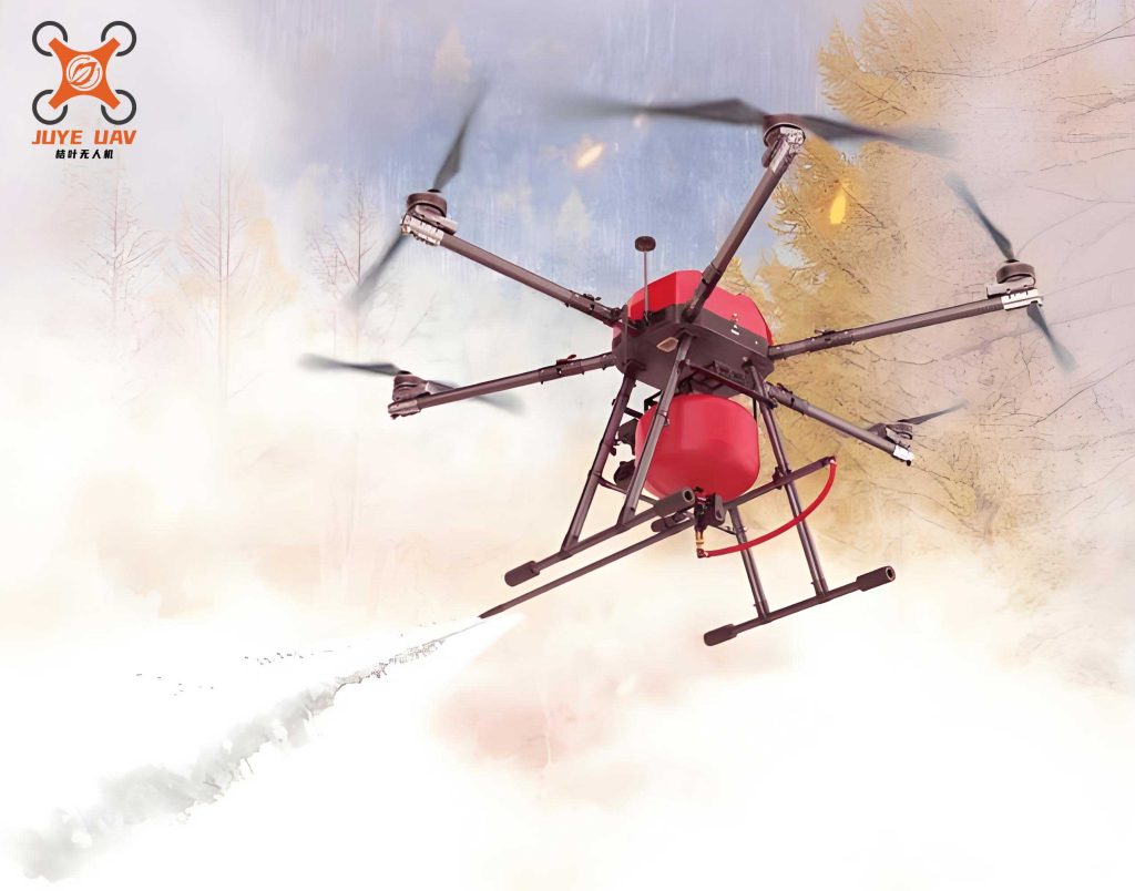
The design of an effective fire drone communication system requires a holistic approach, encompassing architecture, hardware, and software, all rigorously validated through practical testing.
1. System Design Framework
1.1 Overall Architecture
We propose a tri-integrated “Perception-Transmission-Decision” architecture, structured into four distinct layers:
| Layer | Name & Function | Key Components |
|---|---|---|
| Layer 1 | Perception Layer (Drone End): Environmental data acquisition. | Multispectral sensors, RTK positioning module, Obstacle avoidance radar. |
| Layer 2 | Transmission Layer (Communication Relay): Building an air-ground integrated network. | Mesh ad-hoc radio, LTE/5G portable base station, Satellite communication terminal. |
| Layer 3 | Network Layer (Edge Computing): Data preprocessing and AI analysis. | Edge computing node (e.g., NVIDIA Jetson AGX Orin). |
| Layer 4 | Application Layer (Command Center): 3D situational visualization and command dispatch. | GIS-integrated AR command system platform. |
1.2 Core Technologies
The system’s effectiveness hinges on several advanced technologies:
- Communication Payload Technology: Utilizes multi-mode fusion (LTE/5G, satellite, microwave relay) for environmental adaptability. Anti-jamming designs employing frequency hopping and spread spectrum ensure stable transmission in complex electromagnetic settings.
- Autonomous Flight & Obstacle Avoidance: AI-driven algorithms combined with SLAM enable autonomous navigation and path planning in dense smoke or urban environments. Long-endurance solutions, such as hydrogen fuel cells or solar-assisted power, extend operational time beyond traditional Li-ion limits (currently >2 hours).
- Edge Computing Capability: Onboard processing modules allow for real-time video analytics, reducing bandwidth requirements for uplink and drastically improving response latency.
2. Hardware System Design
2.1 UAV Platform Selection and Modification
The fire drone platform must meet stringent requirements for payload, endurance, and stability. Our selection and modification strategy is summarized below:
| Requirement | Target Specification | Selected Solution | Achieved Performance |
|---|---|---|---|
| Payload Capacity | ≥ 3kg for comms equipment | DJI Matrice 300 RTK (Hexacopter) | Max Take-off Weight: 9kg |
| Endurance | ≥ 40 min (hybrid power) | T-Motor 6010S + Gasoline Engine | 65 minutes with hybrid range extender |
| Wind Resistance | ≥ Level 7 (13.8 m/s) | Custom aerodynamic optimization | Stable hover in winds ≤ 20 m/s |
Structural modifications are critical:
1. Modular Payload Bay: Features quick-release mechanisms and composite damping (silicone + spring) to protect sensitive equipment from vibration.
2. Thermal Management System: Incorporates side vents, turbo fans, and heat pipe technology to maintain operation in ambient temperatures up to 50°C.
2.2 Communication Module Hardware Design
The communication payload is a multi-modal suite:
| Module | Function | Hardware Selection | Key Features |
|---|---|---|---|
| Portable LTE Base Station | Provides temporary 4G/5G coverage | Huawei MH5000 Module | Massive MIMO, 500+ terminal capacity |
| Mesh Ad-hoc Radio | Dynamic multi-hop networking | Siklu Ethereal 600 | Dual-band (2.4/5.8 GHz), 1 Gbps throughput, 1000 hops/sec frequency agility |
| Satellite Terminal | Wide-area backbone link | HuaLi ChuangTong HGS-6800 | Supports BeiDou SMS & Inmarsat BGAN |
RF Front-end Optimization is essential:
– Antenna Integration: Combined folded dipole (2.4/5.8 GHz) and helical (4G LTE) antennas with RF switches (e.g., Skyworks SKY13322) for dynamic band switching.
– EMI Shielding: Copper foil and conductive foam within the bay, coupled with shielded coaxial cables (RG-316), ensure a ground resistance ≤ 0.1 Ω.
3. Software System Design
3.1 Core Module Design
| Software Module | Primary Function | Technology/Algorithm |
|---|---|---|
| Communication Relay Management | Dynamic role allocation (router/terminal) | AODV Protocol + SDN Controller (ONOS) |
| AI Data Analytics | Fire recognition, path planning, gas prediction | YOLOv5 + LSTM Model Fusion |
| Security & Encryption | Data integrity, anti-jamming transmission | AES-256 + Quantum Key Distribution (QKD) backup |
| Multi-drone Cooperative Control | Swarm task allocation, conflict avoidance | Modified Artificial Bee Colony (ABC) + Spatio-Temporal Conflict Avoidance (STCA) |
3.2 Communication Protocol & Data Flow Design
The protocol stack is designed for robustness and priority handling:
| Protocol Layer | Protocol/Technology | Purpose |
|---|---|---|
| Physical Layer | 2.4/5.8 GHz Dual-band, OFDM, MIMO | Anti-interference transmission |
| MAC Layer | Dynamic TDMA + CSMA/CA Hybrid | QoS prioritization (Voice > Video > Data) |
| Network Layer | IPv6 over Mesh, SDN Dynamic Routing | Adaptive topology adjustment |
| Application Layer | MQTT + WebRTC | Multi-terminal data fusion & real-time interaction |
Data Flow Design:
– Uplink (Drone → Command): Sensor data (temperature, gas) & video stream → Mesh network → Satellite/Public network → Edge AI node → Command screen.
– Downlink (Command → Drone): AR instructions, BIM models, route plans → Satellite link → Mesh relay → Onboard decoding & execution.
3.3 Core Function Implementation
3.3.1 Communication Relay & Dynamic Networking:
An enhanced AODV protocol with a Link Quality Prediction (LQP) model dynamically selects optimal paths. The LQP can be modeled as a function of signal strength (RSSI), signal-to-noise ratio (SNR), and link stability (L):
$$ LQP(t) = \alpha \cdot RSSI(t) + \beta \cdot SNR(t) + \gamma \cdot \frac{dL}{dt} $$
where $\alpha$, $\beta$, $\gamma$ are weighting coefficients. Dual-band binding boosts throughput to 1.5 Gbps. An LSTM-based spectrum prediction model executes 1000 scans/second to avoid congested channels.
3.3.2 Edge AI Analytics:
– Fire Recognition & Localization: An optimized YOLOv5 model, accelerated with TensorRT, achieves a inference speed ≥ 30 fps on 1080P video.
– Thermal Analysis & Gas Prediction: FLIR thermal data feeds into an LSTM network to predict fire spread direction (error < 5m). Another LSTM model forecasts CO/H2S concentration trends, issuing warnings 30 seconds in advance. The core prediction step can be represented as:
$$ \hat{C}(t+\Delta t) = LSTM_{\theta}(C(t-n:t), T(t-n:t), W(t-n:t)) $$
where $\hat{C}$ is the predicted concentration, $\theta$ are model parameters, $C$ is historical concentration, $T$ is temperature, $W$ is wind data, and $n$ is the historical window size.
4. Performance Testing & Validation
The fire drone system was tested in simulated high-rise fire and earthquake scenarios. Key performance indicators (KPIs) were measured against industry standards:
| Performance Indicator | Industry Standard | Measured Result |
|---|---|---|
| Max Coverage Radius (Single Node) | ≥ 5 km | 8.5 km |
| End-to-End Latency (Video Stream) | ≤ 1 s | 480 ms |
| End-to-End Latency (Sensor Data) | ≤ 1 s | 200 ms |
| Wind Resistance | Level 7 Wind | Stable Hover in Level 12 Wind |
| Continuous Operation Time | ≥ 40 min | 65 min (Hybrid Power) |
The results confirm the system not only meets but exceeds prevailing industry standards, validating the design efficacy of the fire drone platform.
5. Specific Application Scenarios for the Fire Drone System
5.1 On-site Emergency Communication Relay
When terrestrial base stations are damaged or signals are blocked, the fire drone acts as an aerial relay. It can deploy a portable LTE/5G base station (e.g., Huawei MH5000) to provide immediate network coverage for responders and victims. Multiple fire drones can form a self-healing Mesh network, using the enhanced AODV protocol and dual-band switching to extend coverage and maintain connectivity in obstructed environments.
5.2 3D Fireground Situational Awareness
In conditions of thick smoke and high heat, the fire drone fuses data from thermal imagers, HD cameras, and gas detectors. Edge AI performs real-time fire recognition and generates 3D thermal radiation models. This processed data can be overlaid on Building Information Modeling (BIM) data in AR glasses worn by firefighters, providing an intuitive understanding of fire dynamics and structural risks.
5.3 Cross-regional Coordinated Command & Dispatch
For large-scale disasters, a swarm of fire drones can operate cooperatively. Using a modified Artificial Bee Colony (ABC) algorithm for task allocation, different drones assume specialized roles: reconnaissance, communication relay, and visual command projection. Satellite backhaul (e.g., Inmarsat BGAN) ensures constant connectivity with the remote command center, enabling expert guidance for complex on-site operations.
5.4 Rescue Personnel Safety Assurance
The fire drone system enhances firefighter safety through real-time biometric and environmental monitoring. Wearable sensors on firefighters transmit vital signs to the fire drone command platform. Coupled with UWB for cm-level positioning and onboard gas detection, the system can trigger immediate evacuation alerts if a firefighter’s condition deteriorates or environmental toxins reach dangerous levels.
5.5 Post-disaster Assessment & Reconstruction
Equipped with倾斜摄影 cameras, the fire drone can rapidly survey a disaster zone to create centimeter-accurate 3D models. These models enable precise calculation of damaged volume, assessment of infrastructure integrity, and planning for reconstruction and logistics. The collected data also serves to build digital twins for post-incident analysis and future training simulations.
5.6 Technical Challenges and Mitigation Strategies
| Scenario | Primary Challenge | Proposed Mitigation |
|---|---|---|
| High-rise Fire Relay | Signal attenuation due to building blockage | Employ millimeter-wave (60GHz) relays for glass penetration. |
| Dense Urban Monitoring | Multipath effects degrading定位精度 | Use RTK+IMU sensor fusion for dynamic error correction. |
| Long-endurance Demand | Weight penalty of hybrid power systems | Transition to lighter hydrogen fuel cells (in development). |
| Extreme Weather (Storm/High Wind) | Degraded UAV stability | Implement aerodynamic optimization + multi-motor redundancy. |
6. Conclusion and Future Perspectives
The rotor-based fire drone communication system has evolved from an auxiliary tool to a core infrastructure element in firefighting and emergency response. Its role is particularly irreplaceable in scenarios involving broken networks, roads, and power—the so-called “triple-disruption” conditions. The system design presented here, characterized by “hardware modularity + software intelligence,” demonstrates rapid deployment and effective multi-agent cooperation. Its performance has been validated in simulated real-disaster conditions for communication relay, situational awareness, and command dispatch. The future development of the fire drone ecosystem necessitates deeper integration of 5G-Advanced, generative AI, and new energy technologies, concurrently with the establishment of supportive regulatory frameworks for low-altitude airspace management to facilitate its widespread, standardized adoption in disaster relief operations worldwide.