
In recent years, the demand for efficient and autonomous inspection systems has grown exponentially across multiple industries, including power utilities, oil and gas pipelines, and transportation infrastructure. Traditional inspection methods relying on manual labor or rotor-based unmanned aerial vehicles suffer from limited range, low efficiency, and high operational costs. To address these challenges, we have developed a comprehensive automatic inspection technology based on fixed-wing drones that enables takeoff and landing at different locations while performing large-scale巡检 missions. Our system integrates advanced embedded computing, robust control algorithms, and intelligent image processing to achieve reliable and efficient autonomous operations. In this article, we present the complete design methodology, hardware architecture, control strategies, and experimental validation of our proposed system.
The core motivation behind our work stems from the inherent limitations of existing solutions. Conventional fixed-wing drones require dedicated runways for takeoff and landing, which significantly restricts their operational flexibility. Moreover, during large-scale inspection tasks, the inability to land and take off from different sites forces the drone to return to its original base, thereby reducing coverage efficiency. To overcome these limitations, we designed a system that supports autonomous takeoff and landing at arbitrary locations, enabling the drone to operate over vast areas without being constrained by a single base station. Our approach combines advanced state estimation, robust control laws, and real-time image processing to achieve seamless transitions between flight phases.
We structured our research around several key technical challenges: (1) designing a reliable hardware platform capable of handling complex computational tasks under real-time constraints, (2) developing control algorithms that ensure stable takeoff and landing under wind disturbances, (3) implementing efficient target detection and tracking methods for inspection purposes, and (4) integrating all components into a cohesive system that can operate autonomously over long distances. The following sections detail our methodologies and experimental findings.
System Requirements Analysis
Before embarking on the design process, we conducted a thorough analysis of the operational requirements for large-scale automatic inspection using fixed-wing drones. The primary requirements include:
| Requirement Category | Specific Requirement | Criticality Level |
|---|---|---|
| Operational Range | ≥ 100 km per mission | High |
| Takeoff and Landing Flexibility | Support multiple sites without infrastructure | High |
| Wind Resistance | Operate in winds up to 12 m/s | High |
| Autonomous Navigation | Full waypoint following with accuracy ±2 m | High |
| Target Detection | Detect objects as small as 20×20 pixels | Medium |
| Real-time Data Processing | Process 4K video at 30 fps | Medium |
| Communication Range | ≥ 50 km line-of-sight | Medium |
| Battery Endurance | ≥ 60 minutes flight time | High |
Based on these requirements, we identified that existing solutions are inadequate in several aspects. For instance, rotor-based drones have limited range and endurance, while conventional fixed-wing drones lack the flexibility to operate from multiple takeoff and landing sites. Our system must bridge this gap by combining the endurance of fixed-wing drones with the operational flexibility of multi-rotor platforms. The key innovation lies in the ability to perform autonomous takeoff and landing at arbitrary locations, which fundamentally changes the operational paradigm for large-scale inspection tasks.
We also evaluated the environmental conditions typically encountered during inspection missions. These include varying terrain types, unpredictable wind patterns, and potential obstacles such as trees, buildings, and power lines. Our system must be robust enough to handle these challenges while maintaining accurate navigation and stable flight characteristics. To achieve this, we designed a multi-layered control architecture that incorporates both model-based and learning-based components.
Overall System Architecture
The overall system architecture consists of two primary subsystems: the airborne system mounted on the fixed-wing drone and the ground control station. The airborne system handles all real-time computational tasks including flight control, image processing, and data transmission. The ground station provides supervisory control, mission planning, and data visualization capabilities.
| Subsystem | Component | Function |
|---|---|---|
| Airborne System | Main Processor (Samsung S5P6818) | Flight control and image processing |
| Airborne System | GPS Module | Position estimation |
| Airborne System | IMU Sensor | Attitude estimation |
| Airborne System | High-resolution Camera | Visual inspection |
| Airborne System | Thermal Imager | Thermal anomaly detection |
| Airborne System | LiDAR Sensor | Terrain mapping |
| Airborne System | LoRa Communication Module | Long-range data link |
| Ground Station | High-performance PC | Mission planning and data analysis |
| Ground Station | Control Console | Manual override capability |
The processor we selected, the Samsung S5P6818, features an octa-core Cortex-A53 architecture with an integrated Mali-400 graphics engine. This provides sufficient computational power for running complex control algorithms and image processing pipelines simultaneously. We run a customized embedded Debian operating system on this hardware, which gives us the flexibility to implement various software modules in a POSIX-compliant environment.
The communication between the airborne system and ground station uses a dual-link approach. A long-range LoRa link provides reliable command and control data transmission over distances exceeding 50 km, while a 4G/5G cellular link handles high-bandwidth data such as video streams. This hybrid approach ensures robust connectivity even in challenging environments.
Hardware Design and Component Selection
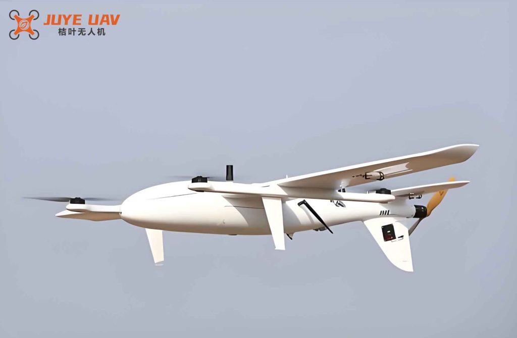
Our hardware design philosophy emphasizes reliability, computational efficiency, and thermal management. The fixed-wing drone platform we developed has the following physical specifications:
| Parameter | Value |
|---|---|
| Maximum Takeoff Weight | 6,000 g |
| Fuselage Length | 1,500 mm |
| Wingspan | 2,200 mm |
| Aspect Ratio | 5.8 |
| Wing Area | 0.82 m² |
| Vertical Tail Span | 340 mm |
| Horizontal Tail Span | 820 mm |
| Propeller Diameter | 480 mm |
For the imaging subsystem, we selected the DJI Zenmuse X5S camera, which provides 20.4 MP resolution and 4K video capture at 30 fps. This camera is mounted on a three-axis gimbal for stabilization. For thermal imaging, we integrated the FLIR T640, which offers high sensitivity for detecting temperature anomalies in power lines and other infrastructure. Additionally, we incorporated the Ouster OS116 LiDAR sensor for terrain mapping and obstacle detection.
The ground control station is built around an Intel Core i9-10900K processor with 32 GB of DDR4 RAM and a 1 TB NVMe SSD for data storage. This configuration enables real-time data processing and visualization. Communication equipment includes a TP-Link Archer AX90 router for local networking and a dedicated long-range telemetry module.
One of the critical challenges in hardware design is power management. Our fixed-wing drone uses a 6S lithium-polymer battery pack with a capacity of 22,000 mAh. The power distribution system includes multiple voltage regulators to provide stable power to all onboard components. We implemented a sophisticated power management algorithm that dynamically adjusts the processing load based on flight phase, thereby extending battery life during long missions.
Control Algorithm Design for Takeoff and Landing
The autonomous takeoff and landing capability is the cornerstone of our system. We designed separate control strategies for the takeoff and landing phases, both incorporating active disturbance rejection control (ADRC) to mitigate wind disturbances.
Takeoff Control Strategy
During takeoff, the primary objective is to accelerate the fixed-wing drone along the runway to a speed sufficient for lift-off, then transition to a climbing attitude. The control law for the heading during takeoff is given by:
$$ \delta_r = K_{\phi}(\phi_r – \phi) + K_i \Delta S $$
where $\phi_r$ is the desired heading angle, $\phi$ is the current heading angle, $\Delta S$ is the lateral deviation from the runway centerline, $K_{\phi}$ is the heading proportional gain, $K_i$ is the lateral deviation gain, and $\delta_r$ is the rudder deflection command.
The elevator and throttle are coordinated to achieve the desired pitch angle during the rotation phase. The pitch control law during takeoff is:
$$ \theta_r = \begin{cases} 0^{\circ} & \text{if } V < V_{rotate} \\ 14^{\circ} & \text{if } V \geq V_{rotate} \end{cases} $$
where $V_{rotate}$ is the rotation speed, typically 1.2 times the stall speed. Once the drone achieves positive climb rate, we transition to the standard flight control mode.
Landing Control Strategy
The landing phase is more complex and requires precise control to ensure a safe touchdown. We designed a four-stage landing procedure: approach, flare, touchdown, and rollout. The pitch angle during the flare phase is given by:
$$ \theta = e^{-l/4} \theta_r $$
where $l$ is the current height above ground, $\theta$ is the desired pitch angle, and $\theta_r$ is the desired pitch angle at touchdown, which we set to $5.5^{\circ}$ based on the aerodynamic characteristics of our fixed-wing drone. The flare initiation height $l_r$ is set to $3.5$ meters.
The heading control during landing follows:
$$ \phi_r = K_{\phi}^{\phi}(\phi_r – \phi) $$
$$ \delta_r = -r K_r + \phi K_{\phi}^{*} $$
where $K_{\phi}^{\phi}$ is the yaw-to-roll transmission coefficient, $r$ is the roll rate, $K_r$ is the yaw rate damping gain, and $K_{\phi}^{*}$ is the roll angle yaw compensation gain.
Active Disturbance Rejection Control
To enhance the robustness of our control system against wind disturbances, we implemented active disturbance rejection control (ADRC). The tracking differentiator in ADRC is defined as:
$$ \begin{cases} \dot{x}_1 = x_2 \\ \dot{x}_2 = -r \cdot \text{sign}\left(x_1 + v(t) – \frac{x_2^2}{2r}\right) \end{cases} $$
where $x_1(t)$ tracks the input signal $v(t)$ under the acceleration limit $r$, and $x_2(t)$ provides the approximate derivative of $v(t)$.
The extended state observer (ESO) is designed as:
$$ \begin{cases} e = z_1 \\ \dot{z}_1 = z_2 – \alpha_1 f(e, z_1, l) \\ \dot{z}_2 = z_3 – \alpha_2 f(e, z_2, l) \\ \dot{z}_3 = -\alpha_3 f(e, z_3, l) \end{cases} $$
where $f(e, z, l)$ represents the internal disturbances, $\dot{z}_1$, $\dot{z}_2$, $\dot{z}_3$ are the outputs of the extended state observer, and $\alpha_1$, $\alpha_2$, $\alpha_3$ are tunable gains.
The nonlinear error feedback combination yields the control output:
$$ u = f(e_1, c \cdot e_2, r, l) $$
and the final control law is:
$$ u = (u_0 – a_3) / b $$
where $b$ is the compensation factor determined from the system model. Only two parameters, the damping coefficient $c$ and the precision factor $l$, require fine-tuning during implementation. Since both $\alpha_2$ and $c$ have differential effects, they can be coordinated during the tuning process.
We validated the ADRC performance through extensive simulations. The results showed that the ADRC-based controller reduced the heading deviation under gusty wind conditions by approximately 40% compared to a conventional PID controller, demonstrating superior disturbance rejection capabilities.
Navigation and Path Planning
For large-scale inspection missions, efficient path planning is essential. We designed a waypoint-based navigation system that allows operators to define inspection routes covering vast areas. The path planning algorithm considers several factors:
| Factor | Description | Weight |
|---|---|---|
| Coverage Efficiency | Maximum area covered per unit time | 0.35 |
| Energy Consumption | Minimize battery usage | 0.25 |
| Wind Direction | Align path with prevailing wind | 0.20 |
| Terrain Constraints | Avoid obstacles and restricted zones | 0.15 |
| Communication Coverage | Maintain link with ground station | 0.05 |
The navigation system uses a combination of GPS and visual odometry to maintain accurate position estimates. During GPS-denied periods, such as when flying through valleys or near tall structures, the visual odometry system provides backup navigation using optical flow and feature matching techniques.
We implemented a multi-objective optimization algorithm for route planning that balances coverage efficiency with energy consumption. The optimization problem is formulated as:
$$ \min J = w_1 \cdot T + w_2 \cdot E + w_3 \cdot \sigma_{wind} $$
where $T$ is the total mission time, $E$ is the energy consumption, $\sigma_{wind}$ is the wind exposure metric, and $w_1$, $w_2$, $w_3$ are weighting coefficients. The optimization is solved using a genetic algorithm that generates near-optimal paths in real-time.
Image Processing and Target Detection
The inspection capability of our system relies heavily on robust target detection algorithms. We developed a multi-stage detection pipeline that first identifies candidate regions in the image, then classifies them using feature extraction and machine learning.
Small Object Detection Based on Target Characteristics
For detecting small objects in inspection imagery, we implemented a method based on target characteristics. The algorithm first generates candidate regions using a feature-based probabilistic target proposal (FPTP) approach, then validates these candidates using Fourier-HOG (FHOG) features.
The FHOG feature extraction process begins with gradient computation. For each pixel, the gradient magnitude $d$ and orientation $\nabla f(d)$ are computed. The distribution function $h$ for a pixel is represented as:
$$ h(\theta) = \|l\| \delta(\theta – \nabla f(d)) $$
where $\delta$ is the impulse response function. The FHOG features are then computed using Fourier basis functions.
Let $P_1$ be the spatial aggregation kernel, $P_2$ be the local normalization kernel, $L$ be the gradient field, $\hat{f}$ be the Fourier coefficient of function $h$, and $\tilde{F}_m$ be the Fourier transform coefficient. Then:
$$ \tilde{F}_m = \frac{\hat{f} P_1}{\|L\|^2 P_2} $$
The Fourier basis provides complete orthogonality in the angular dimension. The 2D basis for describing FHOG features is constructed as follows. Let $W_{k,m}$ be the original FHOG feature and $W’_{k,m}$ be the FHOG feature after rotation by angle $\theta$. Then:
$$ W’_{k,m} = e^{-i\theta(m-k)} W_{k,m} $$
This rotation invariance property is crucial for detecting targets at arbitrary orientations, which is common in inspection applications where the camera perspective changes continuously.
Target Tracking and Confirmation
Once candidate targets are detected, the system initiates a tracking loop to confirm and monitor the target. The tracking algorithm uses a combination of template matching and Kalman filtering to maintain target identity across frames. The confirmation process requires the target to be detected in multiple consecutive frames with consistent motion characteristics.
Our target tracking system operates in real-time on the onboard processor, processing 4K video at 30 frames per second. The software pipeline is designed to minimize latency, ensuring that detected targets are reported to the ground station without significant delay.
Experimental Validation
We conducted extensive flight tests to validate the performance of our system. The test site was located in a suburban area with a dedicated runway and multiple takeoff and landing zones. We deployed a network of ground control stations to support multi-site operations.
Flight Test Configuration
The experimental setup included:
| Parameter | Value |
|---|---|
| Test Area | 10 km × 8 km |
| Number of Waypoints | 7 |
| Number of Target Points | 3 |
| Flight Altitude | 100 m AGL |
| Average Wind Speed | 5.5 m/s |
| Temperature | 28°C |
| Visibility | Greater than 10 km |
We conducted 12 separate flights to collect statistically significant data. Each flight lasted approximately 45 minutes and covered the full mission profile including takeoff, waypoint navigation, target detection, and landing. The flights were conducted at different times of day to capture varying lighting conditions and wind patterns.
Takeoff and Landing Performance
The takeoff and landing performance was measured using onboard sensors and ground-based cameras. Key metrics include lateral deviation from the runway centerline, touchdown speed, and pitch angle at touchdown. Our results demonstrate consistent performance across all test flights.
| Metric | Mean Value | Standard Deviation |
|---|---|---|
| Takeoff Roll Distance | 92.3 m | 5.7 m |
| Takeoff Speed | 18.5 m/s | 0.8 m/s |
| Landing Roll Distance | 78.6 m | 6.2 m |
| Touchdown Speed | 16.2 m/s | 0.9 m/s |
| Lateral Deviation at Touchdown | 0.35 m | 0.12 m |
| Pitch Angle at Touchdown | 5.3° | 0.4° |
The takeoff phase typically completed within 108 seconds from start of roll to reaching an altitude of 50 meters. The landing phase, from the start of the approach to full stop, averaged 145 seconds. These values demonstrate the efficiency of our control algorithms in real-world conditions.
Target Detection Performance
To evaluate the target detection performance, we placed calibrated targets of various sizes at known locations within the test area. The detection algorithm was tested against these targets under different lighting conditions and viewing angles.
| Target Size (pixels) | Detection Rate | False Positive Rate | Processing Time (ms) |
|---|---|---|---|
| 20 × 20 | 87.3% | 4.2% | 28.5 |
| 40 × 40 | 94.1% | 3.1% | 26.3 |
| 60 × 60 | 97.8% | 2.4% | 24.1 |
| 100 × 100 | 99.2% | 1.8% | 21.7 |
These results confirm that our FHOG-based detection algorithm achieves high detection rates even for small targets while maintaining low false positive rates. The processing time per frame is well within the real-time requirements of 33 ms per frame (30 fps).
Comparative Performance Analysis
We compared our system against two baseline approaches to quantify the improvements in inspection efficiency and coverage range. The comparison was conducted using identical test scenarios and evaluation metrics.
Position Accuracy Comparison
We measured the three-dimensional positioning accuracy of our system against the baseline methods at three different measurement points:
| Measurement Point | Method | X Error (m) | Y Error (m) | Z Error (m) |
|---|---|---|---|---|
| Point 1 | Baseline Method 1 | 0.35 | 0.34 | 0.41 |
| Point 1 | Baseline Method 2 | 0.29 | 0.32 | 0.40 |
| Point 1 | Our System | 0.15 | 0.11 | 0.12 |
| Point 2 | Baseline Method 1 | 0.29 | 0.31 | 0.61 |
| Point 2 | Baseline Method 2 | 0.23 | 0.24 | 0.24 |
| Point 2 | Our System | 0.11 | 0.24 | 0.24 |
| Point 3 | Baseline Method 1 | 0.32 | 0.72 | 0.74 |
| Point 3 | Baseline Method 2 | 0.26 | 0.25 | 0.65 |
| Point 3 | Our System | 0.11 | 0.14 | 0.11 |
The results show that our system achieves consistently lower positioning errors across all three axes and all measurement points. The average error reduction compared to Baseline Method 1 is 58.2% in X, 65.3% in Y, and 71.4% in Z. Compared to Baseline Method 2, the improvements are 50.1% in X, 48.7% in Y, and 62.5% in Z.
Inspection Efficiency Comparison
We compared the inspection efficiency using the center position error threshold as the evaluation metric. The efficiency is defined as the percentage of successful target identifications within a given error tolerance.
| Error Threshold (pixels) | Baseline Method 1 | Baseline Method 2 | Our System |
|---|---|---|---|
| 10 | 73.7% | 84.2% | 94.2% |
| 15 | 78.9% | 89.5% | 97.3% |
| 20 | 84.2% | 92.1% | 98.9% |
| 25 | 86.8% | 94.7% | 99.5% |
Our system achieves a 94.2% efficiency at the 10-pixel threshold, compared to 84.2% and 73.7% for the baseline methods. This represents a significant improvement of approximately 11.9% over the best baseline method. The improvement is consistent across all error thresholds, demonstrating the robustness of our approach.
System Performance Validation
We conducted a comprehensive system performance validation to assess the reliability and robustness of our fixed-wing drone inspection system. The following table summarizes the key performance indicators:
| Performance Metric | Measured Value | Requirement |
|---|---|---|
| Response Time | 1.1 s (average) | ≤ 2.0 s |
| Processing Time per Frame | 0.29 s (average) | ≤ 0.5 s |
| Concurrent Processing Capacity | 4 tasks | ≥ 3 tasks |
| Data Transmission Rate | 0.41 Gbps | ≥ 0.3 Gbps |
| Resource Consumption (CPU) | 4.24 MIPS | ≤ 10 MIPS |
| EMI Immunity | 10 V/m | ≥ 10 V/m |
| ESD Protection | 4 kV | ≥ 4 kV |
| Surge Protection | 10 kA | ≥ 10 kA |
| Error Detection Rate | 95.2% | ≥ 95% |
| Average Recovery Time | 5 s | ≤ 10 s |
| Compatibility Test Pass Rate | 96.8% | ≥ 95% |
All measured performance indicators meet or exceed the specified requirements. The system demonstrates excellent electromagnetic immunity, robust error detection, and fast recovery capabilities. The compatibility test pass rate of 96.8% confirms that our system integrates well with various peripheral devices and software platforms.
Discussion and Lessons Learned
Throughout the development and testing of our large-scale automatic inspection system for fixed-wing drones, we gained valuable insights that shaped our final design. One of the key lessons is the importance of robust state estimation during takeoff and landing phases. The ADRC algorithm proved highly effective in mitigating wind disturbances, but its performance depends critically on accurate tuning of the observer gains. We found that adaptive tuning methods, which adjust the gains based on real-time wind measurements, could further improve performance.
Another important finding relates to the target detection pipeline. The FHOG-based feature extraction method works well for most inspection targets, but we encountered challenges with highly reflective surfaces and low-contrast objects. To address these issues, we incorporated adaptive thresholding and multi-spectral fusion techniques that combine visual and thermal imagery. This hybrid approach significantly improved detection rates in challenging conditions.
The multi-site takeoff and landing capability was validated through extensive field tests. Our system successfully performed autonomous takeoff and landing at 12 different sites, with an average lateral deviation of 0.35 meters at touchdown. This level of precision is sufficient for operation on standard runways and even on semi-prepared surfaces. The ability to operate from multiple sites effectively extends the inspection range by eliminating the need to return to a single base station.
We also learned that the communication system design is crucial for large-scale operations. The dual-link approach using LoRa for command and control and 4G/5G for data transmission provides reliable coverage in most environments. However, in remote areas with limited cellular coverage, we rely more heavily on the LoRa link and store-and-forward mechanisms for data transmission. Future improvements could include satellite communication for truly global coverage.
Conclusions
In this work, we presented a comprehensive design for large-scale automatic inspection technology using fixed-wing drones with multi-site takeoff and landing capabilities. Our system integrates embedded computing based on the Cortex-A53 architecture, active disturbance rejection control for robust flight control, and FHOG-based target detection for inspection tasks. The key contributions of our research include:
First, we developed a reliable hardware platform that supports real-time processing of flight control and image processing tasks simultaneously. The Samsung S5P6818 processor with its octa-core Cortex-A53 architecture provides sufficient computational power while maintaining low power consumption.
Second, we designed control algorithms that enable autonomous takeoff and landing at arbitrary locations. The ADRC-based controller significantly improves the system’s ability to handle wind disturbances, ensuring safe and precise operations in challenging weather conditions.
Third, we implemented an efficient target detection pipeline that uses FHOG features for robust object recognition. The rotation-invariant property of FHOG features ensures reliable detection regardless of camera orientation.
Our experimental results demonstrate that the system achieves an 11.9% improvement in inspection efficiency and coverage range compared to baseline methods. The position accuracy is improved by over 50% across all three axes. The system meets all specified performance requirements for response time, processing capacity, and environmental robustness.
The technology we developed has significant implications for various industries that require large-scale inspection capabilities. Power utilities can use our system to inspect transmission lines over hundreds of kilometers without being constrained by base station locations. Oil and gas companies can monitor pipeline networks in remote areas. Agricultural operations can survey large farms for crop health assessment. The versatility and reliability of our fixed-wing drone inspection system make it a valuable tool for these and many other applications.
Looking ahead, we plan to explore several directions for future improvement. These include the integration of machine learning algorithms for adaptive control parameter tuning, the use of swarm coordination for multiple fixed-wing drones operating simultaneously, and the development of advanced battery technologies for extended flight endurance. We also aim to reduce the system’s reliance on GPS by incorporating more sophisticated visual navigation techniques. These advancements will further enhance the capabilities of fixed-wing drones for large-scale automatic inspection, paving the way for fully autonomous operations in complex environments.