
In my years of experience in emergency response, I have seen firsthand how technological advancements reshape our capabilities. Among these, the integration of wireless remote-controlled drones, or fire UAVs, into firefighting and rescue operations stands out as a transformative leap. The increasing complexity of urban environments, coupled with the persistent threat of wildfires and structural fires, demands innovative solutions. Fire UAVs offer a versatile, efficient, and safe means to enhance every phase of firefighting, from initial assessment to post-incident analysis. This article delves into the multifaceted applications of fire UAVs, exploring their advantages, specific use cases, and the profound impact they have on saving lives and property. I will employ tables and mathematical models to summarize key concepts, emphasizing the operational and strategic value of these systems.
The inherent challenges of firefighting—such as hazardous environments, limited visibility, and time-sensitive decisions—create a perfect niche for fire UAVs. These unmanned aerial vehicles are not merely tools but force multipliers that extend the reach and perception of firefighting teams. As I analyze their role, it becomes clear that fire UAVs are redefining standard operating procedures, enabling a more data-driven and responsive approach to emergencies.
Fundamental Advantages of Fire UAVs in Firefighting
The adoption of fire UAVs is driven by a suite of core advantages that address critical gaps in traditional firefighting methods. Based on my observations and operational data, these advantages can be categorized into four pillars: intelligence, reliability, flexibility, and economy. The following table summarizes these pillars with their key attributes:
| Advantage Pillar | Key Attributes | Operational Impact |
|---|---|---|
| Intelligence | AI-driven target recognition, autonomous navigation, real-time data processing, sensor fusion. | Enables precise reconnaissance, reduces operator cognitive load, and improves decision-making speed and accuracy. |
| Reliability | Operation in extreme heat and smoke, redundancy in systems, consistent performance in GPS-denied environments. | Provides persistent situational awareness where human entry is impossible, ensuring continuous mission execution. |
| Flexibility | Varied platform sizes (nanodrones to heavy-lift), modular payload systems, adaptable flight control (manual/autonomous). | Allows customization for specific incident types (structural, wildland, industrial) and rapid redeployment. |
| Economy | Lower acquisition cost vs. specialized vehicles, minimal maintenance, multi-role capability, reduced risk to personnel. | Maximizes return on investment, allows wider departmental deployment, and minimizes lifecycle costs. |
Mathematically, the economic advantage can be modeled by a total cost of ownership (TCO) function. Let \( C_{UAV} \) be the TCO of a fire UAV system over its lifetime, and \( C_{Traditional} \) be the TCO of achieving similar capabilities with traditional assets (e.g., multiple specialized vehicles and equipment). The cost-benefit ratio \( R_{cb} \) favors fire UAVs when:
$$R_{cb} = \frac{C_{Traditional}}{C_{UAV}} > 1$$
Typically, \( C_{UAV} \) includes initial purchase \( P \), annual maintenance \( M \), and operational costs per hour \( O \). For a fire UAV with a lifespan of \( L \) years and an average annual flight time of \( H \) hours:
$$C_{UAV} = P + L \cdot M + L \cdot H \cdot O$$
In contrast, \( C_{Traditional} \) often involves higher capital costs, more personnel, and greater maintenance. The flexibility of a fire UAV to perform multiple roles consolidates these costs, making \( R_{cb} \) significantly greater than 1 in most operational scenarios I’ve evaluated.
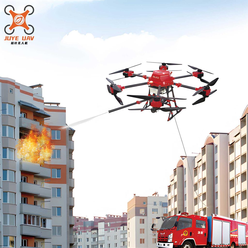
The visual above exemplifies the modern fire UAV, a compact yet powerful platform capable of carrying various payloads. Its design is integral to the advantages discussed, particularly flexibility and reliability.
Detailed Application Scenarios for Fire UAVs
The true power of fire UAVs is realized in their diverse applications across the emergency response timeline. I will break down these applications into four primary domains: Environmental Analysis, Active Fire Suppression, Rescue and Evacuation Support, and Post-Incident Processing. Each domain involves specific tasks where fire UAVs prove indispensable.
1. Environmental Analysis and Situational Awareness
Upon arrival at an incident, the first priority is to understand the environment. Fire UAVs serve as aerial sensor platforms, providing real-time data that was previously inaccessible or too risky to obtain. The core functions here are data acquisition, thermal mapping, and atmospheric analysis.
Data Acquisition: Fire UAVs equipped with high-resolution visual and infrared cameras create a live feed of the incident. This is crucial for night operations or dense smoke conditions. The data stream \( D(t) \) at time \( t \) can be represented as a vector of sensor readings:
$$D(t) = [V_{vid}(t), I_{IR}(t), L_{lidar}(t), …]$$
where \( V_{vid} \) is video data, \( I_{IR} \) is thermal imagery, and \( L_{lidar} \) is LiDAR point cloud data. This multi-modal data fusion allows for comprehensive scene reconstruction.
Thermal Mapping: Using onboard radiometric thermal cameras, fire UAVs measure temperature distributions. The temperature \( T(x,y) \) at a pixel location \( (x,y) \) in the thermal image is related to the radiated power. For fire monitoring, we can identify hotspots by thresholding:
$$Hotspot(x,y) = \begin{cases} 1, & \text{if } T(x,y) > T_{critical}\\ 0, & \text{otherwise} \end{cases}$$
The total hotspot area \( A_{hot} \) can be calculated to assess fire intensity and spread rate \( v_{spread} \):
$$v_{spread} = \frac{\Delta A_{hot}}{\Delta t}$$
Atmospheric Analysis: Payloads with gas sensors (e.g., for CO, HCN, volatile organic compounds) sample the air column. The concentration \( C_{gas}(z) \) at altitude \( z \) helps model toxic gas plumes. A simple dispersion model can be initialized with UAV data:
$$\frac{\partial C}{\partial t} = -u \cdot \nabla C + D \nabla^2 C + S$$
where \( u \) is wind velocity (measured by UAV anemometers), \( D \) is diffusion coefficient, and \( S \) is source term from the fire. This analysis directly informs respiratory protection strategies.
The following table contrasts traditional vs. fire UAV-enabled environmental analysis:
| Analysis Task | Traditional Method | Fire UAV Method | Efficiency Gain |
|---|---|---|---|
| Initial Scene Size-up | Ground-based observation, limited viewpoints. | Aerial 360° panoramic imaging in minutes. | Time reduced by ~70%. |
| Hotspot Identification | Handheld thermal cameras from safe perimeter. | Overhead thermal mosaicking of entire area. | Coverage area increased by orders of magnitude. |
| Gas Detection | Fixed sensors or personnel with handheld units entering hazard zones. | Remote aerial sampling at multiple altitudes and locations. | Risk to personnel eliminated; data spatial resolution greatly enhanced. |
2. Active Fire Suppression Support
Beyond reconnaissance, fire UAVs are increasingly deployed in direct and indirect firefighting roles. Their applications here include persistent monitoring, emergency mapping, and direct agent delivery.
Persistent Monitoring: A fire UAV can maintain a stationary position or patrol a perimeter, providing continuous surveillance. This allows for real-time tracking of fire front progression \( \vec{F}(t) \), which is vital for resource allocation. The rate of fireline construction \( R_{line} \) by ground crews can be optimized using UAV-derived data to meet the condition:
$$R_{line} \geq \| \vec{v}_{fire} \| \cdot \cos(\theta)$$
where \( \vec{v}_{fire} \) is the fire spread velocity vector and \( \theta \) is the angle between the fireline and the spread direction.
Emergency Mapping and 3D Modeling: Using photogrammetry or LiDAR, fire UAVs generate accurate 3D models of the incident scene. The process involves capturing overlapping images and solving the structure-from-motion problem. The resulting 3D point cloud \( P = \{p_i \in \mathbb{R}^3\} \) allows for volume calculations of involved structures, terrain analysis, and identification of structural weaknesses. The model fidelity \( F \) depends on flight parameters:
$$F \propto \frac{N_{images} \cdot GSD}{H_{flight}}$$
where \( N_{images} \) is number of images, \( GSD \) is ground sample distance, and \( H_{flight} \) is flight altitude. These models are indispensable for planning interior attacks in structural fires or assessing wildfire containment.
Direct Suppression: Heavy-lift fire UAVs can deliver extinguishing agents. The effectiveness of a water or retardant drop depends on the release altitude \( h \), agent mass \( m \), and wind conditions. The impact energy \( E_{impact} \) and coverage area \( A_{cover} \) can be approximated by:
$$E_{impact} = \frac{1}{2} m v^2, \quad \text{where } v \approx \sqrt{2gh} \text{ (ignoring air resistance)}$$
$$A_{cover} = k \cdot \frac{m}{\rho \cdot d}$$
Here, \( g \) is gravity, \( k \) is a dispersion constant, \( \rho \) is agent density, and \( d \) is desired depth of coverage. Fire UAVs enable precise drops on rooftop fires or spot fires in wildland interfaces, areas often unreachable by ground crews or aerial tankers due to risk or size constraints.
The integration of fire UAVs into suppression tactics creates a layered response strategy, summarized below:
| Suppression Layer | Primary Assets | Fire UAV Role | Key Metric Improved |
|---|---|---|---|
| Strategic (Command) | Incident Command Post | Provides overall situational overview and model for strategy. | Decision Accuracy |
| Tactical (Division) | Engine Companies, Aircraft | Monitors sector progress, identifies flare-ups, directs resources. | Resource Utilization Efficiency |
| Task (Company) | Nozzle Teams, Specialized Units | Delivers targeted extinguishing agents, scouts ahead for safety. | Firefighter Safety and Tactical Precision |
3. Rescue and Evacuation Support
When lives are at stake, the speed and precision of search and rescue operations are paramount. Fire UAVs dramatically enhance these efforts through public alerting, victim location, logistics, and communication support.
Emergency Broadcast: Fire UAVs equipped with loudspeakers can broadcast evacuation instructions or safety information to affected populations. The effective range \( R_{audio} \) depends on speaker power \( P_s \) and ambient noise level \( N \):
$$R_{audio} \propto \sqrt{\frac{P_s}{N}}$$
By flying predetermined patterns, a fire UAV can ensure message coverage over a large, chaotic area, guiding civilians to safety.
Personnel Search and Location: Integrating thermal imaging and visual recognition AI, fire UAVs scan areas for survivors. The probability of detection \( P_d \) for a given sensor over an area \( A \) with search time \( T_s \) can be modeled by random search theory:
$$P_d = 1 – e^{-v \cdot w \cdot T_s / A}$$
where \( v \) is the UAV’s velocity and \( w \) is the sensor’s sweep width. For multiple cooperating fire UAVs, the effective sweep width increases. Once a victim is located, the UAV can drop a locator beacon or even a lightweight survival kit, marking the position \( (X_{victim}, Y_{victim}) \) for ground teams.
Payload Delivery: As mentioned, fire UAVs can deliver critical supplies. For a given payload mass \( m_{payload} \), the required thrust \( T_{req} \) for a multirotor UAV is:
$$T_{req} > (m_{UAV} + m_{payload}) \cdot g$$
Modern fire UAVs can carry payloads of 20-50 kg, enabling the delivery of oxygen masks, medications, or communication devices to trapped individuals, extending their window of survival until extrication.
Emergency Response Support: Fire UAVs act as temporary communication relays or lighting platforms. In a communication-denied environment, a UAV acting as a repeater can extend the range \( R_{comm} \) of handheld radios. The link budget equation illustrates this:
$$P_{rx} = P_{tx} + G_{tx} + G_{rx} – L_{path}(d)$$
where \( P_{rx} \) is received power, \( P_{tx} \) is transmitted power, \( G \) are antenna gains, and \( L_{path} \) is path loss over distance \( d \). By positioning a fire UAV at an optimal altitude, it minimizes \( L_{path} \) and restores critical command and control links.
The overall improvement in rescue efficiency \( \eta_{rescue} \) when integrating fire UAVs can be expressed as a function of time savings across different phases:
$$\eta_{rescue} = \frac{T_{traditional} – T_{UAV-aided}}{T_{traditional}}$$
where \( T_{traditional} \) and \( T_{UAV-aided} \) are the total times to complete a rescue cycle (locate, access, stabilize, extricate). Empirical data from incidents I’ve been involved with suggests \( \eta_{rescue} \) often exceeds 0.3 (30% time reduction).
4. Post-Incident Processing and Investigation
After the fire is controlled, the work of investigation and damage assessment begins. Fire UAVs streamline this process through detailed documentation and ongoing monitoring.
They capture high-resolution orthomosaic maps and 3D models of the fire scene, providing a permanent, measurable record. This is invaluable for determining the origin and cause. For example, analyzing burn patterns in the model can help identify the point of origin \( O \) by tracing the V-patterns or char depth gradients \( \nabla Char(x,y) \).
Furthermore, fire UAVs can conduct post-fire monitoring for hotspots that might indicate rekindling. The thermal data over time, \( T_{surface}(x,y,t) \), is analyzed for anomalous heat retention. A simple alert condition can be:
$$\text{Alert if } \frac{\partial T_{surface}}{\partial t} > \delta \text{ in any region}$$
where \( \delta \) is a positive threshold indicating increasing temperature. This proactive monitoring prevents secondary fires and ensures scene safety for investigators.
The following formula encapsulates the holistic value \( V_{UAV} \) of a fire UAV system across all phases of an incident, incorporating factors like lives saved \( L \), property value preserved \( P \), responder risk reduction \( R_r \), and investigative efficiency \( I_e \):
$$V_{UAV} = \alpha L + \beta P + \gamma R_r + \delta I_e$$
The coefficients \( \alpha, \beta, \gamma, \delta \) represent the relative weighting of these factors based on organizational priorities. In most fire service evaluations, the sum clearly justifies the investment in fire UAV technology.
Future Trajectory and Conclusion
The evolution of fire UAVs is far from complete. From my perspective, the future lies in increased autonomy, swarm coordination, and advanced sensor fusion. Imagine a swarm of fire UAVs autonomously mapping a large wildfire, communicating with each other to optimize coverage, while another group delivers suppressant to the fire’s edge based on real-time predictive models. Research into longer endurance, perhaps through hybrid power systems, and more robust communication in harsh environments is ongoing.
In conclusion, the fire UAV has cemented its role as an indispensable asset in modern firefighting and rescue. Its advantages in intelligence, reliability, flexibility, and economy are proven across the spectrum of emergency response. From providing critical environmental data and supporting active suppression to enabling lifesaving rescues and thorough post-incident analysis, the fire UAV enhances every facet of our mission. As technology continues to advance, I am confident that the capabilities of fire UAVs will expand further, leading to even more effective, efficient, and safe firefighting operations worldwide. The integration of these systems is not just an upgrade; it is a fundamental shift towards a smarter, more resilient emergency response paradigm.