
From my perspective as a researcher and practitioner in agricultural technology, the integration of drone technology into smart agriculture represents a transformative shift toward more efficient, sustainable, and data-driven farming practices. As global agriculture moves toward precision and intelligence, traditional methods often fall short in terms of resource utilization and adaptability. Drones, with their agility, high-resolution data collection, and automation capabilities, have emerged as a cornerstone of modern smart agriculture. In this article, I will explore the fundamental aspects of smart agriculture, delve into the specific applications of drones, and propose strategies to enhance their effectiveness, with a particular emphasis on the critical role of drone training in ensuring successful adoption. The goal is to provide a comprehensive overview that highlights how drones can optimize agricultural management through advanced technologies, supported by tables and mathematical models to summarize key concepts.
Smart agriculture, often referred to as precision agriculture or digital farming, is an advanced production model that integrates modern information technologies with traditional agricultural practices. It aims to enhance the精细化 of agricultural management through data-driven approaches, leveraging the Internet of Things (IoT), big data, artificial intelligence, remote sensing, and cloud computing. In my experience, this paradigm shift is characterized by several key features that distinguish it from conventional farming. To illustrate these features, I have summarized them in the following table, which provides a clear comparison:
| Feature | Description | Role of Drones |
|---|---|---|
| Informatization | Real-time data collection and analysis of soil, weather, and crop conditions using IoT and big data. | Drones equipped with sensors capture high-resolution imagery and spectral data, enabling continuous monitoring. |
| Precision | Personalized management of fields through accurate sensing and targeting, minimizing resource waste. | Drones enable precise applications such as variable-rate spraying and灌溉 based on spatial variability. |
| Automation | Automation of production processes from planting to harvesting using intelligent devices. | Drones operate autonomously along pre-defined paths, reducing manual labor and increasing efficiency. |
| Efficiency | Optimization of workflows through real-time monitoring and智能决策支持, boosting overall productivity. | Drones expedite tasks like crop scouting and mapping, saving time and costs while improving outcomes. |
These features collectively drive the adoption of drones in agriculture, as they align perfectly with the need for rapid, accurate, and scalable solutions. From my viewpoint, the transition to smart agriculture is not just about technology deployment but also about rethinking agricultural practices through a lens of sustainability and innovation.
Drones, or unmanned aerial vehicles (UAVs), have found diverse applications in smart agriculture, each contributing to enhanced productivity and resource management. I will discuss four primary areas where drones are making a significant impact: precision pesticide spraying, crop growth monitoring, pest and disease control, and irrigation management. These applications leverage the无人机’s ability to collect and process data in real-time, enabling farmers to make informed decisions.
First, in precision pesticide spraying, drones offer a highly efficient and environmentally friendly alternative to traditional methods. By utilizing GPS and pre-programmed flight paths, drones can adjust spraying rates and飞行速度 based on crop density and地理特征. This minimizes chemical drift and reduces pesticide usage, as shown in the following formula that models the optimal spraying volume:
$$ V = \frac{A \times C \times \rho}{E} $$
Where \( V \) is the spraying volume (in liters), \( A \) is the area covered (in hectares), \( C \) is the desired concentration of pesticide (in g/L), \( \rho \) is the crop density factor (dimensionless), and \( E \) is the drone’s spraying efficiency (typically between 0.8 and 0.95). This formula allows for customized applications, ensuring that每一块田地 receives the appropriate amount of chemical, thereby protecting ecosystems and reducing costs. In my observations, drones can cover large fields quickly, with some models capable of treating up to 50 hectares per hour, significantly outpacing manual or tractor-based spraying.
Second, drones play a crucial role in monitoring crop growth conditions. Equipped with multispectral and thermal imaging sensors, they capture data on chlorophyll content, nitrogen levels, and photosynthetic efficiency. These parameters are essential for assessing crop health and predicting yields. For instance, the Normalized Difference Vegetation Index (NDVI) is commonly used to evaluate plant vigor, calculated as:
$$ NDVI = \frac{NIR – Red}{NIR + Red} $$
Here, \( NIR \) represents near-infrared reflectance, and \( Red \) is red light reflectance, both obtained from drone sensors. Values closer to 1 indicate healthier vegetation. Drones enable frequent monitoring across seasons, building long-term databases that support predictive analytics. The table below summarizes key crop monitoring parameters and their significance:
| Parameter | Measurement Method | Importance |
|---|---|---|
| Chlorophyll Content | Multispectral imaging (e.g., using indices like NDVI) | Indicates photosynthetic activity and nutrient status; helps in detecting stress early. |
| Nitrogen Utilization | Spectral analysis in visible and NIR bands | Critical for growth; deficiencies can reduce yield; drones enable precise fertilizer application. |
| Water Stress | Thermal imaging to measure canopy temperature | High temperatures may signal drought stress; guides irrigation scheduling. |
| Biomass Estimation | 3D mapping via LiDAR or photogrammetry | Predicts yield and monitors growth patterns over time. |
Third, in pest and disease control, drones facilitate early detection and targeted intervention. Through high-resolution cameras and multispectral sensors, they identify symptoms such as leaf discoloration or wilting, often before they are visible to the naked eye. This allows for rapid response, reducing crop losses. Drones can generate distribution maps of affected areas, enabling farmers to apply treatments only where needed. The effectiveness of such monitoring can be quantified using a detection accuracy model:
$$ Accuracy = \frac{TP + TN}{TP + TN + FP + FN} $$
Where \( TP \) is true positives (correctly identified pests), \( TN \) is true negatives, \( FP \) is false positives, and \( FN \) is false negatives. Advanced drones equipped with machine learning algorithms can achieve accuracies above 90%, making them invaluable for integrated pest management. Moreover, historical data collected by drones helps in predicting outbreak patterns, allowing for preventive measures like crop rotation or resistant variety selection.
Fourth, drones assist in irrigation management by monitoring soil moisture levels. Using infrared and thermal sensors, they create湿度 maps that highlight areas with water deficits or excesses. This data supports precision irrigation, optimizing water use and reducing waste. A common approach involves calculating the Crop Water Stress Index (CWSI) from thermal imagery:
$$ CWSI = \frac{T_c – T_w}{T_d – T_w} $$
Here, \( T_c \) is the canopy temperature, \( T_w \) is the wet reference temperature (fully watered crop), and \( T_d \) is the dry reference temperature (water-stressed crop). Values range from 0 (no stress) to 1 (severe stress), guiding irrigation decisions. Drones can cover entire fields in a single flight, providing real-time insights that enable dynamic irrigation scheduling. This is especially beneficial in regions with water scarcity, as it promotes sustainable resource use.
To maximize the benefits of drone technology in smart agriculture, several strategies must be implemented. Based on my experience, I propose four key recommendations: enhancing technical research and development, improving智慧农业 infrastructure, elevating the skills of farmers and managers through drone training, and fostering the integration of drones with other smart technologies. Each of these areas is interlinked and critical for widespread adoption.
First,加大技术研发力度 is essential to advance drone智能化水平. This includes improving navigation精度, developing autonomous decision-making algorithms, and enhancing data analytics capabilities. Investment in R&D can lead to drones that perform complex tasks like species identification or adaptive spraying without human intervention. For example, path planning algorithms can be optimized using formulas such as the Traveling Salesman Problem (TSP) to minimize flight time:
$$ \min \sum_{i=1}^{n} \sum_{j=1}^{n} d_{ij} x_{ij} $$
Subject to constraints that ensure each field sector is visited once, where \( d_{ij} \) is the distance between points \( i \) and \( j \), and \( x_{ij} \) is a binary variable indicating travel. Such innovations require collaboration between tech companies, research institutes, and agricultural bodies, supported by government funding and incentives.
Second,完善智慧农业基础设施 is foundational for drone operations. This involves deploying IoT sensors, robust data storage systems, and high-speed communication networks like 5G in rural areas. These elements enable seamless data transmission from drones to centralized platforms, where information is processed and visualized for decision support. The table below outlines key infrastructure components and their functions:
| Component | Function | Impact on Drone Applications |
|---|---|---|
| IoT Sensor Networks | Collect real-time data on soil, weather, and crops | Provides ground-truth data that complements drone imagery, improving accuracy. |
| Cloud Data Platforms | Store and analyze agricultural data | Enables big data analytics and historical trend analysis, supporting predictive models. |
| 5G Communication | High-speed, low-latency connectivity | Facilitates real-time drone control and data streaming, even in remote fields. |
| GNSS (e.g., GPS) | Precision positioning for navigation | Ensures accurate flight paths and geotagging of collected data. |
Third, and crucially,提升农户及农业管理人员的技术水平 through comprehensive drone training programs. In my view, the success of drone technology hinges on the ability of end-users to operate and interpret data effectively. Drone training should cover basic piloting skills, data采集与分析, and agricultural management techniques. Regular hands-on workshops and online courses can bridge knowledge gaps, especially for farmers in偏远地区. For instance, a structured drone training curriculum might include modules on safety regulations, maintenance, and application-specific operations. I emphasize that drone training is not a one-time event but an ongoing process to keep pace with technological advancements. By investing in drone training, we empower agricultural communities to leverage drones for improved productivity and sustainability. To illustrate the importance of this, consider the following formula that relates training effectiveness to operational efficiency:
$$ E_{op} = \alpha \cdot T_{score} + \beta \cdot E_{tech} $$
Where \( E_{op} \) is operational efficiency (e.g., task completion rate), \( T_{score} \) is a measure of drone training proficiency (on a scale of 0 to 1), \( E_{tech} \) represents the technical capabilities of the drone, and \( \alpha \) and \( \beta \) are weighting coefficients. Studies show that well-trained operators can boost efficiency by up to 40%, highlighting the value of drone training.
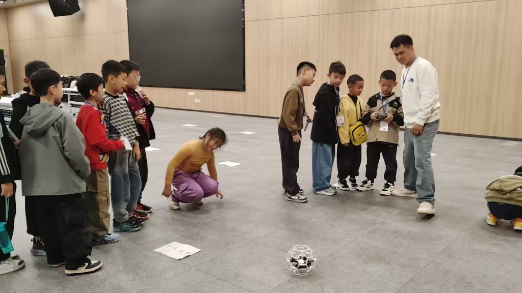
As shown in the image above, effective drone training involves practical sessions where farmers learn to handle drones in field conditions. This hands-on approach is vital for building confidence and competence. Furthermore, drone training should be tailored to local needs, considering crop types and regional challenges. Governments and agricultural extensions can play a key role by establishing drone training centers and certification programs, ensuring that skills are standardized and recognized.
Fourth,推动无人机与其他智能化农业技术联合应用 can unlock synergies that enhance overall farm management. For example, integrating drones with IoT sensors allows for comprehensive environmental monitoring, while combining drone data with AI algorithms enables predictive analytics for yield forecasting. A practical application is in smart irrigation systems, where drones provide soil moisture data that automatically adjusts sprinkler schedules. This integration can be modeled using a system efficiency equation:
$$ SE = \frac{\sum_{i=1}^{n} (O_i \cdot w_i)}{\sum_{i=1}^{n} (I_i \cdot w_i)} $$
Where \( SE \) is system efficiency, \( O_i \) are outputs (e.g., crop yield, water savings), \( I_i \) are inputs (e.g., labor, resources), and \( w_i \) are weights assigned to each factor. By fostering collaboration between technology providers and agricultural stakeholders, we can develop integrated platforms that streamline operations and maximize resource use.
In conclusion, drone technology is a pivotal enabler of smart agriculture, driving improvements in precision, efficiency, and sustainability. From precision spraying to growth monitoring, drones offer versatile solutions that address the limitations of traditional farming. However, to fully realize their potential, we must focus on continuous innovation, robust infrastructure, and, most importantly, comprehensive drone training for farmers and managers. The future of agriculture lies in the seamless融合 of drones with emerging technologies like AI and big data, creating intelligent ecosystems that optimize every aspect of production. As I reflect on this journey, it is clear that drones are not just tools but catalysts for a greener, more productive agricultural era, and ongoing drone training will be the backbone of this transformation. By embracing these strategies, we can build resilient farming systems that meet global food demands while preserving our environment for generations to come.