
In recent years, the proliferation of low-altitude, slow-speed, and small unmanned aerial vehicles (UAVs) has surged exponentially, presenting significant public safety challenges. From my perspective as a researcher in this field, the rise of consumer-grade drones has introduced new risks, including unauthorized surveillance, smuggling, and potential terrorist activities. Regulatory frameworks, such as China’s UAV registration rules and flight management policies, have been established to address these issues, but effective enforcement requires advanced technological solutions. This article delves into the research and implementation of an integrated anti-UAV system, designed to detect, identify, and counteract non-cooperative drones. I will elaborate on the system’s architecture, components, operational workflow, and functionalities, emphasizing the critical role of multi-sensor fusion and intelligent countermeasures. Throughout this discussion, the term “anti-UAV” will be frequently highlighted to underscore the system’s core purpose.
The development of anti-UAV technologies has evolved rapidly, with various methods explored globally. Traditional approaches include radar detection, electro-optical tracking, radio frequency (RF) monitoring, and kinetic or non-kinetic interventions like jamming and net capture. However, consumer drones pose unique challenges due to their “low, slow, and small” (LSS) characteristics, which complicate detection and increase false alarms. In our work, we have designed a comprehensive anti-UAV system that integrates diverse sensors and countermeasure tools to form a robust defense network. This system not only addresses non-cooperative threats but also supports the management of cooperative drones through flight services, aligning with regulatory mandates. Below, I present a detailed exposition, enriched with tables and mathematical models, to encapsulate our findings and innovations.
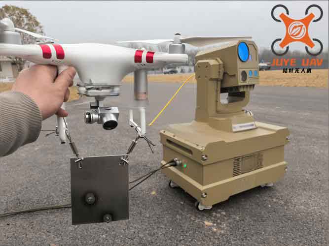
The anti-UAV system is architected around three core subsystems: the Command and Control (C2) system, the Detection and Identification system, and the Countermeasure system. This integrated design ensures seamless coordination from threat detection to neutralization. The C2 system serves as the brain, processing data from various sources, including civil aviation authorities and drone cloud platforms, to provide situational awareness and decision support. The Detection and Identification system combines radar, electro-optical, and RF sensors to achieve high-accuracy tracking and classification of UAVs. Finally, the Countermeasure system employs jamming, net capture, and other techniques to mitigate threats. A summary of the system architecture is presented in Table 1, highlighting the interconnections and data flows.
| Subsystem | Components | Primary Function | Data Integration |
|---|---|---|---|
| Command and Control (C2) | Data Processing, Operator Consoles, Online Services | Centralized data fusion, decision-making, and user interface | Integrates inputs from detection sensors and external sources (e.g., air traffic management) |
| Detection and Identification | Low-Altitude Radar, Electro-Optical Sensors, RF Detectors | Detect, track, and classify UAVs and operators | Feeds target data to C2 for analysis and threat assessment |
| Countermeasure | Link Jammers, Navigation Jammers, Net Capture Devices | Neutralize UAVs through interference or physical capture | Receives engagement commands from C2 and provides feedback on effectiveness |
From a mathematical standpoint, the system’s detection capability can be modeled using radar and signal processing equations. For instance, the radar range equation for detecting small UAVs is given by:
$$P_r = \frac{P_t G_t G_r \lambda^2 \sigma}{(4\pi)^3 R^4 L}$$
where \(P_r\) is the received power, \(P_t\) is the transmitted power, \(G_t\) and \(G_r\) are the antenna gains, \(\lambda\) is the wavelength, \(\sigma\) is the radar cross-section of the UAV, \(R\) is the range, and \(L\) represents system losses. This equation highlights the challenges in detecting LSS targets due to their low \(\sigma\) values, necessitating advanced signal processing techniques. Similarly, RF detection relies on signal-to-noise ratio (SNR) calculations:
$$SNR = \frac{S}{N} = \frac{P_{signal}}{k T B}$$
where \(S\) is the signal power, \(N\) is the noise power, \(k\) is Boltzmann’s constant, \(T\) is the temperature, and \(B\) is the bandwidth. Our anti-UAV system employs adaptive algorithms to enhance SNR for better drone identification.
The system’s components are meticulously designed to address various threat scenarios. The Detection and Identification subsystem comprises three main elements: radar, electro-optical, and RF sensors. Each plays a distinct role in overcoming environmental and target-based limitations. For example, radar provides all-weather, wide-area coverage but may suffer from clutter; electro-optical sensors offer high-resolution imagery for visual confirmation; and RF detectors capture control and video transmission signals for fingerprinting. Table 2 summarizes the specifications and performance metrics of these components, based on our implementation.
| Component | Technology | Detection Range | Key Features | Limitations |
|---|---|---|---|---|
| Low-Altitude Radar | Pulsed Doppler | Up to 5 km | 360° coverage, automatic tracking, low false alarm rate | Limited by terrain and small radar cross-section |
| Electro-Optical Sensor | Visible and Infrared Cameras | Up to 3 km (day), 2 km (night) | High-resolution imaging, laser rangefinder, auto-tracking | Weather-dependent (e.g., fog, rain) |
| RF Detector | Wideband Spectrum Analysis | Up to 10 km (depending on signal strength) | Identifies drone models by RF signatures, locates operators | Susceptible to spectrum congestion |
In our anti-UAV system, the operational workflow is segmented into distinct zones: alert zone, interference zone, and safe zone. This zoning strategy optimizes resource allocation and minimizes collateral effects. When a UAV enters the alert zone, the detection sensors activate, collecting data on its trajectory, speed, and RF emissions. The C2 system then fuses this information to assess the threat level using a weighted scoring model:
$$T = w_1 \cdot D + w_2 \cdot S + w_3 \cdot I$$
where \(T\) is the threat score, \(D\) is the distance from protected assets, \(S\) is the speed, \(I\) is the identification confidence (e.g., confirmed as hostile), and \(w_1, w_2, w_3\) are weighting factors adjusted based on operational rules. If the threat exceeds a threshold, the system proceeds to the interference zone, where jamming is applied. The jamming effectiveness can be expressed as:
$$J = \frac{P_j G_j}{P_d G_d} \cdot \frac{1}{R^2}$$
where \(P_j\) is the jamming power, \(G_j\) is the jamming antenna gain, \(P_d\) is the drone’s signal power, \(G_d\) is its antenna gain, and \(R\) is the range. This formula guides the power settings for link and navigation jammers. Finally, in the safe zone, net capture devices are deployed for physical interception. The entire process is automated, with human oversight for critical decisions.
The functionalities of our anti-UAV system are comprehensive, spanning detection, identification, countermeasures, and support services. I will elaborate on each category, emphasizing how they contribute to a holistic defense. First, the detection and identification functions ensure early warning and accurate classification. Radar detection provides continuous surveillance, capable of tracking multiple targets simultaneously. The electro-optical system enables visual verification and recording, which is crucial for forensic analysis. RF detection not only identifies drones but also geolocates operators using direction-finding techniques, such as time-difference-of-arrival (TDOA) modeled by:
$$\Delta t = \frac{\sqrt{(x – x_i)^2 + (y – y_i)^2} – \sqrt{(x – x_j)^2 + (y – y_j)^2}}{c}$$
where \(\Delta t\) is the time difference between sensors at positions \((x_i, y_i)\) and \((x_j, y_j)\), \((x, y)\) is the operator’s location, and \(c\) is the speed of light. This enhances the system’s ability to support law enforcement actions against malicious actors.
Second, the countermeasure functions are designed to neutralize threats with minimal collateral damage. Link jamming disrupts the control and video transmission signals, forcing the drone into failsafe modes like return-to-home or landing. Navigation jamming targets GPS, GLONASS, and other satellite signals, causing loss of positioning. The choice of jamming strategy depends on the threat assessment and environmental factors. For instance, in urban areas, we prefer soft-kill methods like jamming over hard-kill options to avoid debris hazards. Net capture provides a physical means of seizure, especially effective for close-range threats. Table 3 compares these countermeasure techniques, highlighting their applications and limitations in anti-UAV operations.
| Technique | Mechanism | Effective Range | Advantages | Disadvantages |
|---|---|---|---|---|
| Link Jamming | Blocks control and video RF signals | 1-3 km | Non-destructive, reversible effects | May affect nearby legitimate communications |
| Navigation Jamming | Disrupts satellite navigation signals | 500 m-2 km | Forces drone to hover or land, wide coverage | Potential impact on other GPS-dependent systems |
| Net Capture | Physical entrapment using propelled nets | 50-200 m | No electronic interference, allows evidence collection | Short range, requires precise aiming |
Third, the command and control functions provide the overarching management framework. The C2 system integrates data from all subsystems, displaying real-time situational awareness on operator consoles. It supports flight management for cooperative drones, including plan submission, airspace information, and weather services. Administrative functions handle user registration, compliance monitoring, and violation recording. From a data perspective, the system employs big data analytics to predict threat patterns, using machine learning models for anomaly detection. For example, a support vector machine (SVM) classifier can distinguish between benign and malicious drone behaviors based on flight parameters:
$$f(\mathbf{x}) = \text{sgn}\left(\sum_{i=1}^n \alpha_i y_i K(\mathbf{x}_i, \mathbf{x}) + b\right)$$
where \(\mathbf{x}\) is the feature vector (e.g., speed, altitude, trajectory deviation), \(y_i\) are labels, \(\alpha_i\) are Lagrange multipliers, \(K\) is a kernel function, and \(b\) is the bias. This enhances the anti-UAV system’s proactive capabilities.
Moreover, the online service platform extends the system’s reach to drone operators and regulators. Through web and mobile apps, users can access flight planning tools, airspace status, and regulatory updates. This fosters compliance and reduces unintentional violations, thereby complementing the defensive aspects of the anti-UAV system. Data from these services are fed back into the C2 system to refine threat models, creating a feedback loop that improves overall effectiveness.
In terms of performance evaluation, we have conducted extensive testing to validate the anti-UAV system’s capabilities. Key metrics include detection probability (\(P_d\)), false alarm rate (\(FAR\)), and engagement success rate (\(ESR\)). These are derived from field trials and simulations, with results summarized in Table 4. The data demonstrate the system’s reliability across various environmental conditions, though challenges remain in dense urban settings where multipath effects degrade RF detection.
| Metric | Definition | Target Value | Achieved Value (Average) | Notes |
|---|---|---|---|---|
| Detection Probability (\(P_d\)) | Probability of correctly identifying a UAV | > 0.95 | 0.97 | Based on fused sensor data |
| False Alarm Rate (\(FAR\)) | Rate of false positives per hour | < 0.1 | 0.05 | Reduced by machine learning filters |
| Engagement Success Rate (\(ESR\)) | Probability of neutralizing a threat | > 0.9 | 0.92 | Includes jamming and net capture |
| Response Time | Time from detection to countermeasure activation | < 10 seconds | 8 seconds | Critical for fast-moving drones |
The mathematical underpinnings of these metrics involve statistical models. For instance, \(P_d\) can be expressed using the Neyman-Pearson lemma for hypothesis testing:
$$P_d = \int_{Z_1} f(\mathbf{x}|H_1) d\mathbf{x}$$
where \(H_1\) is the hypothesis that a UAV is present, \(f(\mathbf{x}|H_1)\) is the probability density function under \(H_1\), and \(Z_1\) is the decision region. Similarly, \(FAR\) is given by:
$$FAR = \int_{Z_1} f(\mathbf{x}|H_0) d\mathbf{x}$$
with \(H_0\) being the null hypothesis (no UAV). Our anti-UAV system optimizes these trade-offs through adaptive thresholding.
Looking ahead, the evolution of anti-UAV technology will likely incorporate artificial intelligence, swarm countermeasures, and quantum sensing. Our system is designed with modularity in mind, allowing for upgrades as new threats emerge. For example, deep learning algorithms can enhance image recognition for drones in cluttered backgrounds, while coordinated jamming techniques could address drone swarms. The integration of these advancements will further solidify the role of anti-UAV systems in national security and public safety.
In conclusion, the anti-UAV system presented here represents a holistic solution to the growing challenge of rogue drones. By combining multi-sensor detection, intelligent identification, and layered countermeasures, it achieves a high level of protection for critical infrastructure and public spaces. The system’s design emphasizes scalability, interoperability, and compliance with regulatory standards, making it suitable for diverse applications. From my perspective, ongoing research and collaboration are essential to stay ahead of adversarial innovations. As drone technology continues to advance, so too must our anti-UAV capabilities, ensuring a safe and secure airspace for all.