
In my years of research and practical involvement in emergency response technologies, I have witnessed the transformative impact of fire UAVs on modern rescue operations. The integration of unmanned aerial vehicles, particularly fire UAVs, has revolutionized how we approach disaster management, offering unparalleled advantages in speed, safety, and data acquisition. This article delves into the current state of fire UAV applications, exploring their需求分析,实战应用,技术瓶颈, and future directions, all while emphasizing the critical role of these systems in enhancing救援 efficiency.
The adoption of fire UAVs stems from their inherent benefits: compact size, cost-effectiveness, ease of deployment, and resilience in hazardous environments. These attributes make fire UAVs ideal for scenarios where traditional methods fall short, such as in confined spaces, complex terrains, or life-threatening situations. In the context of emergency rescue, fire UAVs have evolved from mere aerial platforms to sophisticated tools capable of高空立体侦察, real-time monitoring, and精准数据采集. As I reflect on the progression, it is clear that fire UAVs are not just辅助设备 but integral components of a数字化应急通信 ecosystem.
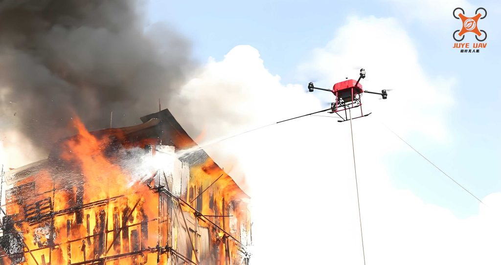
To understand the demand for fire UAVs in rescue operations, I have categorized their primary functions based on实战经验. The core需求 revolves around rapid information gathering and dissemination, which directly influences指挥决策. Below is a table summarizing key applications and their specifications, highlighting how fire UAVs address various救援 challenges.
| Application | Description | Key Requirements | Typical Fire UAV Features |
|---|---|---|---|
| Aerial Photography | Real-time video transmission for situational awareness | High-resolution cameras, low-latency streaming | 4K video, gimbal stabilization |
| Panoramic Imaging | 360-degree views for comprehensive scene assessment | Fast stitching algorithms, wide-angle lenses | Automated panorama capture, mobile app integration |
| Orthophoto Mapping | 2D maps for平面精度 and terrain analysis | High平面精度, moderate resolution | GPS-guided flight paths, photogrammetry software |
| 3D Modeling | 三维重建 of disaster sites for post-event analysis | Variable精度: low for real-time, high for复盘 | Multiple camera angles, cloud processing capabilities |
| Thermal Imaging | Heat signature detection for搜救 in low-visibility conditions | Infrared sensors, temperature sensitivity | Dual-camera systems (visible + IR), real-time heat maps |
| Payload Delivery | Transport of essentials like medical supplies or communication devices | Stable flight under load, precision dropping mechanisms | Modular payload bays, automated release systems |
From my observations, the实战应用 of fire UAVs has become increasingly prominent in diverse rescue scenarios. For instance, in a typical operation, fire UAVs are deployed immediately upon arrival at a disaster site. They provide aerial oversight, allowing responders to identify hazards, locate victims, and plan interventions without exposing personnel to danger. A notable案例 involved a search-and-rescue mission in a dense, inaccessible area at night. Using a fire UAV equipped with thermal imaging, the team quickly detected a heat signature amidst cool surroundings, leading to a successful rescue within minutes. This exemplifies how fire UAVs enhance效率 by reducing搜救 time and minimizing risks. The mathematical representation of such efficiency can be expressed through a simple公式 for operational effectiveness:
$$ E_f = \frac{S_r}{T_t \times R_c} $$
where \( E_f \) is the effectiveness factor of the fire UAV, \( S_r \) is the搜救 success rate, \( T_t \) is the time taken for deployment and data acquisition, and \( R_c \) is the risk coefficient for human responders. Higher \( E_f \) values indicate better performance, underscoring why fire UAVs are prioritized in modern救援 protocols.
However, the integration of fire UAVs is not without challenges. As I have encountered in field deployments, several技术瓶颈 hinder optimal utilization. One major issue is the复杂飞行环境. Urban settings with tall buildings, electromagnetic interference, and adverse weather conditions can disrupt fire UAV operations. For example, GPS signal loss or collision risks due to obstacles are common. To mitigate this, I propose a formula for safe飞行范围 based on environmental factors:
$$ R_s = \frac{P \times V_{max}}{\sqrt{(W_i + A_t)}} $$
Here, \( R_s \) represents the safe operational range, \( P \) is the signal power, \( V_{max} \) is the maximum velocity of the fire UAV, \( W_i \) is the wind interference, and \( A_t \) is the ambient turbulence. This equation helps in planning flights to avoid炸机 incidents, ensuring that fire UAVs remain reliable tools.
Another significant bottleneck is the建模输出效率. While fire UAVs can capture vast amounts of data for 3D modeling, the processing pipeline often causes delays. Traditional workflows involve data export, on-site modeling, and sharing, which are time-consuming and resource-intensive. In救援 situations, speed is critical; thus, there is a trade-off between精度 and timeliness. I have developed a framework to optimize this process, as shown in the table below, comparing different approaches for fire UAV data handling.
| Method | Processing Time (minutes) | 精度 Level | Suitability for Real-Time Rescue | Required Resources |
|---|---|---|---|---|
| On-Site Modeling with High-Performance工作站 | 60-120 | High | Low (due to delay) | Heavy: powerful电脑, stable power supply |
| Cloud-Based Processing | 15-30 | Medium | Medium | Moderate: internet connectivity, subscription services |
| Streaming Real-Time Feeds | 0-5 | Low (但 sufficient for指挥) | High | Light: direct transmission to command center |
| Hybrid Approach (combining streams and cloud) | 10-20 | Medium-High | High | Moderate: integrated systems, 5G networks |
From this table, it is evident that a hybrid approach leveraging cloud computing and real-time streaming offers the best balance for fire UAV operations, ensuring that critical information is available promptly without compromising细节 for post-event analysis.
Furthermore, the problem of数据孤岛 persists in current fire UAV ecosystems. Many fire UAV platforms operate independently, with proprietary software that lacks interoperability with existing指挥 systems like图综 or实战指挥 platforms. This fragmentation complicates data integration, forcing operators to use multiple devices and increasing workload. In my experience, this limits the scalability of fire UAV deployments. To address this, I advocate for standardized communication protocols that enable seamless data exchange. A mathematical model for data融合 efficiency can be described as:
$$ F_d = \sum_{i=1}^{n} \frac{C_i \times I_i}{D_i} $$
where \( F_d \) is the fusion efficiency, \( C_i \) is the compatibility score of the i-th fire UAV system, \( I_i \) is the data integrity, \( D_i \) is the delay in transmission, and \( n \) is the number of systems integrated. Higher \( F_d \) values indicate better synergy, which is essential for coordinated救援 efforts involving multiple fire UAVs.
Looking ahead, the future of fire UAVs in emergency rescue is promising, driven by advancements in AI, 5G, and物联网 technologies. For instance, AI-powered video analytics can enhance the autonomous capabilities of fire UAVs, enabling real-time object detection (e.g., identifying trapped individuals) and predictive modeling of disaster spread. 5G networks will facilitate ultra-low latency communication, allowing fire UAVs to transmit high-definition feeds instantly, even in crowded频谱 environments. Additionally, the integration of IoT sensors with fire UAVs can create a comprehensive monitoring network, as illustrated in the following table on potential enhancements.
| Technology | Application in Fire UAV | Expected Impact on Rescue Operations | Implementation Challenges |
|---|---|---|---|
| Artificial Intelligence (AI) | Autonomous navigation, anomaly detection, speech recognition for victim communication | Reduced operator burden, faster decision-making | Algorithm training data, ethical concerns |
| 5G Communication | High-speed data transmission, network slicing for prioritized rescue traffic | Near-instant video streaming, improved reliability | Infrastructure costs, coverage in remote areas |
| Blockchain | Secure data logging for问责 and traceability of fire UAV actions | Enhanced trust in rescue data,防篡改 records | Scalability issues, energy consumption |
| Edge Computing | On-board processing to reduce latency in data analysis | Real-time insights without cloud dependency | Hardware limitations, heat management |
| Swarm Intelligence | Coordinated fleets of fire UAVs for large-scale搜救 | Expanded coverage, redundant systems for reliability | Complex control algorithms, interference risks |
In conclusion, as I reflect on the evolution of fire UAVs in emergency rescue, it is clear that these systems have become indispensable. From需求分析 to实战应用, fire UAVs offer a blend of versatility and效率 that traditional methods cannot match. However, overcoming技术瓶颈 such as environmental challenges, processing delays, and data孤岛 is crucial for unlocking their full potential. By embracing technological innovations and fostering跨部门协作, we can further integrate fire UAVs into rescue frameworks, ultimately saving more lives and reducing operational risks. The journey of fire UAVs is far from over; with continuous improvement, they will undoubtedly shape the future of emergency response, making our communities safer and more resilient.
To quantify the overall effectiveness of fire UAV deployments, I often use a composite metric that accounts for multiple factors. This metric, termed the Fire UAV Performance Index (FUPI), can be calculated as:
$$ FUPI = \alpha \cdot \frac{A_c}{T_d} + \beta \cdot \frac{D_q}{C_o} + \gamma \cdot \frac{S_a}{R_i} $$
where \( A_c \) is the area coverage per mission, \( T_d \) is the time delay, \( D_q \) is the data quality, \( C_o \) is the operational cost, \( S_a \) is the safety improvement, and \( R_i \) is the risk incidence. The coefficients \( \alpha \), \( \beta \), and \( \gamma \) are weighting factors adjusted based on mission priorities (e.g., \( \alpha = 0.4 \), \( \beta = 0.3 \), \( \gamma = 0.3 \) for搜救-focused operations). Higher FUPI scores indicate superior performance, guiding agencies in optimizing their fire UAV fleets.
In summary, the integration of fire UAVs into emergency rescue represents a paradigm shift towards smarter, safer, and more efficient operations. As we continue to innovate, these aerial platforms will not only assist but also lead救援 efforts, proving that technology, when harnessed correctly, can be a lifeline in times of crisis. The key lies in addressing current limitations while exploring new horizons, ensuring that every fire UAV deployment maximizes its impact on saving lives and protecting property.