
From my extensive experience in modern firefighting tactics, the integration of advanced technology is no longer a luxury but a necessity. Among these technological leaps, multirotor Unmanned Aerial Vehicles (UAVs), specifically designed and deployed as fire UAV platforms, have fundamentally altered our operational capabilities in dense, complex urban environments. This article delves into the technical foundations, practical applications, and future trajectory of these indispensable tools, arguing for their central role in enhancing situational awareness, ensuring firefighter safety, and improving rescue outcomes.
1. Technical Foundations of Multirotor Fire UAVs
A multirotor fire UAV is an unmanned aircraft lifted and propelled by three or more rotors. Its flight mechanics are distinctly different from traditional helicopters. While a helicopter uses a complex swashplate mechanism to change the pitch of its main rotor blades, a multirotor adjusts its attitude and trajectory solely by varying the rotational speed of its fixed-pitch rotors. This simplicity in mechanical design is compensated by sophisticated electronic closed-loop control of the spatial distribution and flight attitude.
1.1. Configurations and Aerodynamic Principles
Common rotor configurations include the X, Y, H, and “+” layouts. The choice of configuration impacts stability, payload distribution, and sensor field-of-view. The fundamental aerodynamic force is thrust (T), generated by each rotor. For a given rotor, thrust can be approximated by:
$$ T = k_T \cdot \rho \cdot n^2 \cdot D^4 $$
where $k_T$ is the thrust coefficient, $\rho$ is air density, $n$ is the rotational speed, and $D$ is the rotor diameter. The total thrust vector is the sum of thrusts from all rotors. Yaw control is achieved by exploiting the difference in total torque between counter-rotating rotor pairs. For instance, in a quadcopter (X-configuration), increasing the speed of clockwise rotors while decreasing the speed of counter-clockwise rotors results in a net yawing moment.
The power required for a rotor is given by:
$$ P = k_P \cdot \rho \cdot n^3 \cdot D^5 $$
where $k_P$ is the power coefficient. This cubic relationship with rotational speed highlights the energy consumption challenges for fire UAV operations, especially under high payload.
1.2. System Architecture of a Typical Fire UAV Platform
A deployable fire UAV system is a synergy of an aerial platform and a ground control station (GCS).
| Aerial Platform Modules | Ground Control Station (GCS) Modules |
|---|---|
|
|
2. Inherent Advantages of Fire UAVs in Urban Contexts
The urban canyon—a landscape of tall buildings, narrow streets, and dense infrastructure—presents unique challenges. The fire UAV excels here due to its inherent design advantages:
2.1. Operational Simplicity and Rapid Deployment
The mechanical simplicity translates to reliability and ease of maintenance. A trained two-person crew can deploy a medium-sized fire UAV within minutes of arrival on scene. There is no need for runways or large clear areas; vertical take-off and landing (VTOL) capability allows operation from confined spaces like courtyards or even fire truck roofs.
2.2. Unparalleled Mobility and Access
A fire UAV can navigate spaces impassable to ground crews. It can hover outside a shattered 30th-story window, peer into deep building cavities masked by smoke, or fly through narrow gaps between structures to assess the rear of a building. This mobility provides a perspective previously unattainable without risking a helicopter or firefighter.
2.3. Enhanced Stability and Fault Tolerance
Modern multirotor platforms, especially hexacopters (6 rotors) and octocopters (8 rotors), are designed with redundancy. The failure of a single motor/rotor does not necessarily lead to a crash. The flight controller can often compensate by adjusting the speeds of the remaining rotors to maintain stable, albeit degraded, flight. This fault tolerance is critical for operations over populated areas or active fire grounds. The stability condition for a hexacopter after one motor failure can be analyzed by solving for the new equilibrium in the force and moment equations:
$$ \sum_{i=1, i\neq f}^{6} \mathbf{T}_i + \mathbf{T}_f = \mathbf{W} $$
$$ \sum_{i=1, i\neq f}^{6} (\mathbf{r}_i \times \mathbf{T}_i) + \mathbf{r}_f \times \mathbf{T}_f = \mathbf{0} $$
where $\mathbf{T}_i$ is the thrust vector of the i-th motor, $\mathbf{W}$ is the weight vector, $\mathbf{r}_i$ is the position vector from the center of mass, and motor $f$ has failed ($\mathbf{T}_f = 0$). A capable flight controller can find a solution for the remaining $\mathbf{T}_i$ to maintain hover.
2.4. High Modularity and Mission Flexibility
The fire UAV is a versatile platform. Its payload bay and attachment points are designed for swift interchange of mission-specific modules. Within minutes, a drone can be reconfigured from a thermal mapping mission to a loudspeaker communication mission or a light delivery mission. This “one platform, multiple tools” philosophy drastically increases cost-effectiveness and operational readiness.
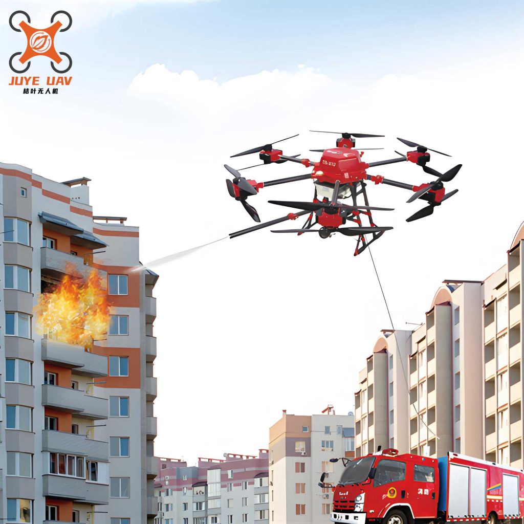
3. Strategic Application Pathways in Firefighting and Rescue
The integration of the fire UAV into the standard incident command system creates new tactical pathways. Its applications can be mapped across the timeline of a fire incident.
| Incident Phase | Fire UAV Application | Key Payloads | Operational Impact |
|---|---|---|---|
| Initial Reconnaissance & Size-up | Rapid aerial assessment from a safe distance. Establishing a 360-degree view of the incident. | Zoom camera, thermal camera. | Provides immediate intel on fire location, extent, and potential paths of spread (exposures). Informs initial resource deployment. |
| Active Firefighting & Dynamic Assessment | Persistent overwatch. Tracking fire progression inside structures (e.g., cockloft fires, warehouse ceilings). Identifying structural weaknesses. | Primary: Thermal camera. Secondary: Zoom camera. | Enables dynamic risk assessment. Alerts command to impending flashover, backdraft conditions, or structural collapse hazards. Guides interior attack teams. |
| Search & Rescue (SAR) Operations | Rapid scanning of inaccessible areas (rooftops, balconies, behind barriers). Life detection in collapse zones. | Thermal camera, RGB camera, loudspeaker. Specialized: SAR radar or acoustic sensor. | Accelerates victim localization. The loudspeaker can provide calming instructions or guide trapped individuals to visible locations for rescue. |
| Communication & Lighting Support | Establishing a temporary communications relay. Providing mobile area lighting for night operations. | Loudspeaker, mesh radio repeater, high-lumen LED array. | Mitigates communication dead zones in large or complex structures. Illuminates work areas for extrication or equipment setup, enhancing safety and efficiency. |
| Active Intervention & Support | Delivering critical supplies. Performing targeted exterior attack on inaccessible fire pockets. | Payload release mechanism (for ropes, masks, radios). Integrated water/foam delivery system or external fire suppressant cartridge. | Extends operational reach. Can deliver survival gear to trapped victims or initiate attack on external fires threatening exposures or hindering escape routes. |
3.1. Mathematical Modeling for Situational Awareness
The data from a fire UAV‘s thermal camera is not just visual; it is quantitative. By analyzing temperature gradients, we can model fire growth. A simple heat flux model from a burning compartment visible to the drone can be expressed as:
$$ \dot{Q}” = \epsilon \sigma (T_f^4 – T_a^4) + h_c (T_f – T_a) $$
where $\dot{Q}”$ is the heat flux per unit area, $\epsilon$ is the emissivity, $\sigma$ is the Stefan-Boltzmann constant, $T_f$ is the flame/temperature seen by the thermal camera, $T_a$ is the ambient temperature, and $h_c$ is the convective heat transfer coefficient. Tracking changes in $T_f$ over time for different building segments allows for predictive modeling of fire spread.
3.2. Optimizing Search Patterns
For SAR in a large debris field, the fire UAV flight path can be optimized. A common efficient pattern is the expanding square search, which can be parameterized. If the drone starts at coordinates $(x_0, y_0)$ and the required visual coverage per leg is $d$, the $n$-th leg of the pattern can be defined by:
$$ \text{Leg}_n: \begin{cases}
x_n = x_0 + \left\lfloor\frac{n+1}{2}\right\rfloor \cdot d \cdot \cos\left(\frac{\pi}{2}(n \mod 4)\right) \\
y_n = y_0 + \left\lfloor\frac{n+1}{2}\right\rfloor \cdot d \cdot \sin\left(\frac{\pi}{2}(n \mod 4)\right)
\end{cases}
$$
for $n = 1, 2, 3, …$. This systematic approach ensures complete coverage without unnecessary overlap, saving critical time.
4. The Future Trajectory: Next-Generation Fire UAV Capabilities
The evolution of the fire UAV is accelerating. Future developments will focus on overcoming current limitations and unlocking new autonomous functions.
4.1. Increased Payload and Endurance
The primary constraint for direct firefighting intervention is payload capacity. Future platforms will utilize hybrid gas-electric powertrains, advanced battery chemistries, and optimized aerodynamics to carry heavier loads (e.g., more water, larger suppressant tanks, or specialized tools). The relationship between payload $(m_p)$, flight time $(t)$, and total system power $(P_{total})$ is crucial:
$$ t \approx \frac{E_{battery}}{P_{total}} = \frac{E_{battery}}{P_{hover}(m_{empty} + m_p) + P_{payload}} $$
where $P_{hover}$ is the power required to hover per unit mass, $m_{empty}$ is the empty mass of the fire UAV, and $P_{payload}$ is the power consumed by the mission payload. Research aims to maximize $E_{battery}$ and minimize $P_{hover}$ and $m_{empty}$ to improve $t$ for a given $m_p$.
4.2. Advanced Autonomy and Swarm Intelligence
Beyond remote piloting, the future fire UAV will operate with greater autonomy. Key areas include:
- Autonomous Navigation in GPS-Denied Environments: Using Simultaneous Localization and Mapping (SLAM) with LiDAR and visual sensors to fly inside smoke-filled buildings.
- Automated Inspection Routines: Pre-programmed flights for post-fire structural integrity assessment.
- Swarm Operations: Multiple fire UAV units working cooperatively. One drone could map a building, another could track heat signatures, and a third could deliver extinguishing agents, all coordinated by a central AI. Swarm dynamics can be modeled using boid-like rules with fire-specific constraints:
$$ \mathbf{v}_i(t+1) = w_1\mathbf{v}_i(t) + w_2\mathbf{v}_{coh} + w_3\mathbf{v}_{sep} + w_4\mathbf{v}_{align} + w_5\mathbf{v}_{target} + w_6\mathbf{v}_{hazard} $$
where the velocity of drone $i$ is updated based on cohesion, separation, alignment with neighbors, attraction to the target (fire), and repulsion from hazards (high heat, obstacles).
4.3. Enhanced Sensor Fusion and Decision Support
Future systems will not just stream video; they will analyze it in real-time. AI algorithms will fuse thermal, visual, and gas sensor data to automatically identify hazards (leaking cylinders, electrical arcs), count potential victims via thermal signatures, and overlay this analyzed information directly onto 3D building models in the command center, providing an unprecedented common operational picture.
| Future Capability | Description | Key Enabling Technologies |
|---|---|---|
| Heavy-Lift Fire Suppression | UAVs capable of carrying 100+ kg of water/foam, acting as initial attack platforms for high-rise fires. | Hylectric propulsion, tethered power systems (for unlimited endurance), advanced lightweight composite tanks. |
| Fully Indoor Autonomous SAR | UAVs that can independently enter, search, and map collapsed or unstable structures without a pilot’s direct control. | Robust LiDAR/SLAM, AI for obstacle negotiation in chaotic environments, ultra-wideband (UWB) for positioning. |
| Integrated “Fire Cloud” Network | A swarm of UAVs forming a resilient, mobile communication and data-processing network over a major incident. | Mesh networking, edge computing on UAVs, standardized data protocols (e.g., TAK). |
5. Conclusion
The adoption of multirotor fire UAV technology represents a paradigm shift in urban firefighting and rescue. It has moved aerial support from a rare, resource-intensive option (manned helicopters) to a routine, scalable, and immensely flexible tool available on the first alarm. By providing a safe, elevated, and mobile perspective, the fire UAV enhances every phase of incident management—from initial size-up and dynamic risk assessment to victim search and targeted intervention. The ongoing advancements in autonomy, payload, and swarm intelligence promise to further cement its role as a central pillar in the future fireground ecosystem, saving lives and protecting property with ever-greater efficiency and safety for firefighters. The integration of this technology is not merely an upgrade to existing practices; it is the foundation for a new, more informed, and more effective era of emergency response.