
Based on the development patterns of modern industrial systems, intelligent equipment and digital industrialization will become key areas of scientific research in the next phase. Currently, intelligent logistics has achieved relatively mature flight control systems, hardware manufacturing processes, and satellite-based navigation functions. However, research on the safe operation and flight conflict early warning technology of large fixed-wing UAV remains insufficient to meet the construction requirements of intelligent equipment and its application standards. It also fails to satisfy the infrastructure needs for big data and Internet of Things applications in the digital industry. Through preliminary analysis and accumulated research, we summarize the current operational situation, flight methodologies, and verification conclusions, providing direction for further application exploration.
In this paper, we present our investigation into the joint flight application of large fixed-wing UAV in mixed airspace for intelligent logistics. Our work focuses on establishing a safety operation mechanism and flight conflict early warning technology for large fixed-wing UAV operating alongside manned transport aircraft. We leverage the advantages of large fixed-wing UAV converted from manned transport aircraft, which offer significant payload capacity, extended range, and robust navigation capabilities. The following sections detail our research progress, technical achievements, and practical applications.
1. Background and Technical Trends
Current research on UAV safe operation can be categorized into three types: (1) optimizing airborne navigation equipment and analyzing navigation data to improve detection sensitivity; (2) improving algorithms for trajectory tracking and path planning using relative distance optimal solutions; and (3) establishing risk assessment parameters for airspace safety. These studies have enhanced flight safety but have not produced a quantitative evaluation framework that comprehensively considers other airspace participants, air traffic service rules, and airborne navigation equipment performance. The main challenges include the lack of mathematical description for performance characteristics and the absence of integration between UAV flight data and manned aircraft flight data, preventing joint flight operations without safety standards and conflict warning methods.
Our approach addresses these gaps by focusing on flight data and navigation parameters, optimizing the Phased Trajectory Deviation (PTD) evaluation model, and establishing navigation specifications and flight rules for fixed-wing UAV. We also utilize Onboard Performance Monitoring and Alerting (OPMA) characteristics and Actual Navigation Performance (ANP) monitoring standards to enable safe operation and conflict early warning. The public market data shows a rapid growth in the UAV industry, with the market size reaching 40.1 billion CNY in 2021. We summarize the development trends in a table below.
| Year | Market Size (CNY Billion) |
|---|---|
| 2016 | 16.8 |
| 2017 | 21.5 |
| 2018 | 27.8 |
| 2019 | 33.2 |
| 2020 | 37.6 |
| 2021 | 40.1 |
The key trends we identify include: (1) system technology moving toward larger, longer-endurance, and network-cluster-based fixed-wing UAV; (2) low-altitude flight safety standard development, with companies like EHang and Volocopter leading efforts; and (3) high operational complexity requiring multi-party coordination. These trends underscore the necessity of establishing navigation specifications and conflict warning mechanisms for large fixed-wing UAV in mixed airspace.
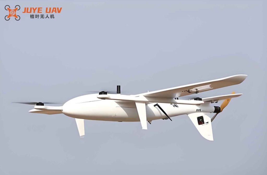
We highlight the critical role of the large fixed-wing UAV platform. Below is an illustration of a typical large fixed-wing drone used in our studies:
2. Current Research Achievements
2.1 Data Preprocessing and OPMA Feature Mining
We take large fixed-wing UAV as the research object and preprocess historical flight trajectories, deviation factors, trajectory gaps, and airborne navigation equipment performance. The OPMA data samples exhibit diversity due to different navigation principles. We apply machine learning algorithms such as Support Vector Machine (SVM) and K-Means clustering to classify data quality and enhance the accuracy of OPMA performance feature extraction. The mathematical formulation for the classification process can be expressed as follows:
Let the feature vector for each data point be $$ \mathbf{x}_i \in \mathbb{R}^d $$. The SVM objective is:
$$ \min_{\mathbf{w},b} \frac{1}{2}\|\mathbf{w}\|^2 + C\sum_{i=1}^{n} \xi_i $$
subject to $$ y_i(\mathbf{w}^T \phi(\mathbf{x}_i) + b) \ge 1 – \xi_i, \quad \xi_i \ge 0 $$
For K-Means, we minimize the within-cluster sum of squares:
$$ J = \sum_{k=1}^{K} \sum_{i \in C_k} \|\mathbf{x}_i – \boldsymbol{\mu}_k\|^2 $$
These algorithms allow us to discover patterns in the large, heterogeneous dataset associated with fixed-wing UAV navigation performance.
2.2 Safety Operation Mechanism
Large fixed-wing UAV operate through multiple flight phases: takeoff, departure climb, cruise, approach descent, and landing. We differentiate deviations from the planned trajectory and optimize the PTD evaluation model to incorporate both deviation severity and contributing factors. The PTD model is defined as:
$$ PTD = \frac{1}{N} \sum_{j=1}^{N} \left( \frac{\Delta d_j}{\sigma_j} \right)^2 $$
where $$ \Delta d_j $$ is the lateral deviation at waypoint j, and $$ \sigma_j $$ is the standard deviation of the allowed error. By associating PTD with navigation accuracy and considering total system error and collision probability requirements from ICAO, we initially formulate navigation specifications for fixed-wing UAV. The safety evaluation results under different airspace densities are shown in the following table.
| Airspace Density (km³) | Flight Safety Level (events/hour) |
|---|---|
| 0.5×10⁻³ | 2.5×10⁻⁸ |
| 1.0×10⁻³ | 4.0×10⁻⁸ |
| 1.5×10⁻³ | 5.8×10⁻⁸ |
| 2.0×10⁻³ | 7.5×10⁻⁸ |
| 2.5×10⁻³ | 9.2×10⁻⁸ |
We also apply a multi-level model to assign weights to factors such as trajectory control, navigation accuracy, and deviation alert categories, thereby mitigating risks and establishing joint flight rules.
2.3 Flight Conflict Early Warning Theory
During actual flight, the navigation accuracy of fixed-wing UAV varies continuously. We use Artificial Neural Networks (ANNs) combined with theoretical accuracy intervals of primary navigation devices. The flight template model is employed to correlate required navigation performance (RNP) values. The ANNs have convergence properties that allow the actual navigation accuracy to be maintained within an acceptable range, ensuring that trajectory deviations remain stable and small. The relationship between theoretical accuracy and actual navigation performance (ANP) can be expressed as:
$$ \sigma_{\text{ANP}} = \min_{\theta} \left( \frac{1}{M} \sum_{m=1}^{M} \left( \frac{d_m – \hat{d}_m}{\sigma_m} \right)^2 \right) $$
where $$ \theta $$ represents the network parameters. This provides a theoretical basis for conflict early warning.
2.4 Risk Identification and Joint Flight Verification
Deviation accumulation leads to off-track events that trigger flight conflicts. We apply fuzzy theory and grey system theory to typify navigation data, combined with navigation specification accuracy classifications and ANP monitoring, to predict yaw trends. A Deep Belief Network (DBN) is used for risk identification, which clusters optimization and builds decision trees. Based on transport aircraft flight procedure protection zones and buffer zone design standards, we establish multi-level avoidance zones for fixed-wing UAV navigation specifications. The table below compares the radii of avoidance zones under different evaluation methods.
| Evaluation Method | Inner Radius (km) | Outer Radius (km) |
|---|---|---|
| PTD-based | 3.762 | 15.000 |
| GBAS-based | 3.116 | 4.607 |
These zones enable the monitoring of deviation accumulation, prediction of off-track events, and early warning of flight conflicts for large fixed-wing UAV in mixed airspace.
3. Applications of Our Research
3.1 Intelligent Logistics
By establishing navigation specifications and a safety operation mechanism for fixed-wing UAV in mixed airspace, along with multi-level avoidance zones, we reduce the risk of uncontrolled UAV flight. This leverages the large payload and long range of fixed-wing UAV to promote intelligent logistics technology. Companies can deploy these UAV for long-haul cargo delivery with enhanced safety guarantees.
3.2 Emergency Rescue
Our navigation specifications and spatial position monitoring methods are adaptable to emergency rescue scenarios. They alleviate coordination difficulties with other airspace users and solve problems of poor communication and slow conventional logistics. Large fixed-wing UAV with high payload and long endurance are especially valuable in delivering relief supplies to remote or disaster-stricken areas.
4. Innovations
Three main innovations are highlighted:
1) Scientific processing of big data to establish navigation specifications for fixed-wing UAV. By combining machine learning (SVM, K-Means) with the PTD evaluation model, we classify and quantify open, multi-source, and non-uniform data. This provides mathematical descriptions of OPMA performance features and required core functions, enabling the formulation of navigation specifications and flight rules for large fixed-wing UAV.
2) Innovative calculation of navigation deviations and accuracy classification standards. Navigation and trajectory data often appear as intervals. Through ANNs and flight template models, we develop methods to analyze spatial position interval data. The convergence property of ANNs allows effective segmentation and classification, correlating with required navigation performance and establishing accuracy classification criteria for fixed-wing UAV.
3) Design and implementation of intelligent conflict early warning for joint flight. Trajectory deviations exhibit cumulative effects that are difficult to monitor. Using fuzzy theory and grey system theory, we typify navigation and trajectory data, combined with theoretical accuracy classification and ANP monitoring, to predict yaw trends. This provides a new approach for capturing cumulative data features and equips fixed-wing UAV with conflict early warning capability.
5. Conclusion
Large fixed-wing UAV converted from manned transport aircraft exhibit excellent performance in payload, airworthiness, and endurance, with maximum takeoff weights reaching 3–10 tons, flight durations up to 8 hours, and ranges around 2,500 km. The widespread deployment of the BeiDou satellite system and 5G communication technology provides reliable support for fixed-wing UAV operations.
Due to the stringent requirements of civil aviation airspace flight standards and air traffic services, and the lack of safe navigation specifications for UAV, the development of intelligent logistics based on UAV platforms has been slow. Through our work, we have utilized PTD optimization models and navigation accuracy classification standards, employing data preprocessing, feature screening, and quality control methods for trajectory and navigation data. This enables data monitoring, cumulative identification, and trend prediction of flight trajectory deviations for fixed-wing UAV, providing a safety operation mechanism and flight conflict early warning method for joint flight in mixed airspace. We effectively control safety risks and improve the feasibility of joint UAV operations.
In summary, by establishing navigation specifications and ANP monitoring for fixed-wing UAV, we leverage proactive flight monitoring and risk identification capabilities. This provides basic safety assurance for UAV flight, accelerates the implementation of joint flight in mixed airspace, and highlights the advantages of rapid, convenient, and precise logistics in low-altitude airspace, ultimately promoting the development of intelligent logistics technology.