
Large-scale infrastructure projects in China demand continuous and reliable safety monitoring during both construction and operation phases. Traditional manual inspection and fixed-point sensing methods suffer from low frequency, poor efficiency, delayed response, and isolated data, especially when facing wide areas with complex terrain. To address these limitations, our research team developed an intelligent slope safety monitoring system that integrates China UAV autonomous inspection, oblique photogrammetry 3D modeling, AI-based defect recognition, and big data visualization. This system was deployed on a major infrastructure project (Phase I) in Fuzhou, focusing on a 1.5 km urban road section with numerous newly cut slopes adjacent to railway piers and buildings. By deploying a China UAV automated airfield, the system achieves daily high-frequency inspections, monthly 3D model comparisons for macro deformation tracking, and real-time AI detection of cracks, water accumulation, and other hazards. The unified data platform breaks information silos and provides panoramic, data-driven decision support. This paper presents the system architecture, key technologies, and field validation results, offering a practical technical pathway for digital transformation in civil engineering safety management.
1. Introduction
In the context of China’s rapid urbanization, large-scale earthwork projects generate numerous high-steep slopes whose long-term stability is critical for overall project safety. Traditional approaches, such as manual patrols and GNSS-based single-point monitoring, are increasingly inadequate for modern demands of precision, frequency, and intelligence. Manual inspections are labor-intensive, subjective, and cannot cover extensive areas daily. Fixed sensors provide only discrete data, missing the overall deformation trend. Moreover, emergency response after extreme weather events (typhoons, rainstorms) is often delayed due to road closures and safety risks for personnel.
The rapid advancement of China UAV technology offers a transformative solution. China UAVs equipped with high-resolution cameras can autonomously fly along pre-planned routes, capturing multi-angle imagery with centimeter-level accuracy. Combined with oblique photogrammetry, these images generate detailed 3D models that reveal millimeter-scale surface changes. Deep learning algorithms further enable automatic identification of cracks, water pooling, and other anomalies. When integrated with a cloud-based geographic information system (GIS), the entire monitoring process becomes automated, visualized, and intelligent.
Our project chose the Station South Road section as a pilot, where the terrain is highly variable and slopes are adjacent to critical railway infrastructure. By deploying a China UAV autonomous airfield system, we aimed to overcome three major challenges: (1) wide monitoring area requiring high-frequency coverage, (2) complex deformation modes spanning macro-displacement and micro-cracks, and (3) slow emergency response with lagging hazard detection. This paper details the system design, algorithms, and field results, demonstrating that the proposed solution significantly enhances monitoring frequency (from weekly to daily), spatial coverage (from points to surfaces), and detection accuracy (from manual to AI).
2. Project Overview and Challenges
Our project covers an area of approximately 14.41 km², including logistics warehouses, industrial plants, and extensive infrastructure such as road networks, flood control systems, and power utilities. The massive earthwork created numerous slopes with heights up to 30 m. The pilot test area—Station South Road—is a 1.5 km long urban secondary road (30 m width, four lanes). Along this route, the terrain fluctuates significantly, crossing multiple newly formed road cuts and approaching railway bridge piers and adjacent buildings. The engineering environment is complex, with potential geological hazards distributed discontinuously.
Table 1 summarizes the three primary challenges we encountered in slope safety monitoring.
| Challenge | Description | Traditional Limitation |
|---|---|---|
| Wide area, high frequency | Key slopes spread over 1.5 km linear section; need daily inspection especially during rainy seasons | Manual patrols at weekly intervals; cannot cover all slopes daily |
| Complex deformation modes | Macro-scale whole-slope displacements and micro-scale local cracks; need both global and local awareness | Single-point sensors (GNSS, inclinometers) miss spatial trends; manual crack detection is subjective and slow |
| Slow emergency response | Sudden slope failures after typhoons or heavy rain; need immediate post-event imagery and risk assessment | Access roads may be blocked; personnel cannot reach site safely; information delay leads to missed intervention windows |
These challenges motivated us to design an automated, three-dimensional, and intelligent monitoring system centered on China UAV technology.
3. System Architecture and Methodology
Our overall approach consists of three interconnected modules: (1) autonomous high-frequency inspection using a China UAV airfield, (2) macro deformation monitoring via multi-temporal oblique photogrammetry, and (3) intelligent hazard detection using deep learning. The following subsections describe each module in detail.
3.1 Automated High-Frequency Inspection
We deployed an unmanned airfield (drone-in-a-box) system at a high point overlooking the Station South Road area. The China UAV is equipped with a 20 MP wide-angle camera and supports network RTK for centimeter-level takeoff, landing, and flight. Using a high-resolution Digital Elevation Model (DEM) and terrain-following algorithms, we designed a strip-shaped inspection route along the road corridor. The flight parameters are given in Table 2.
| Parameter | Value |
|---|---|
| Flight height (above slope top) | 80 m |
| Forward overlap | 80% |
| Side overlap | 70% |
| Ground sample distance (GSD) | Approx. 2 cm |
| Mission frequency | 3 times per day (morning, noon, afternoon) |
| Total route length per mission | ~4 km (including both sides of road) |
The automated workflow is: the airfield opens, the China UAV takes off, flies the pre-planned route while capturing geo-tagged images, returns to the airfield, and automatically uploads images to the cloud server. This increases inspection frequency from once a week (manual) to three times per day, a 21-fold improvement. In emergency situations (e.g., typhoon warning), the system can be triggered remotely to perform an extra inspection within minutes.
3.2 Macro Deformation Monitoring via Oblique Photogrammetry
To capture the overall three-dimensional deformation of all slopes, we adopted oblique photogrammetry. During a monthly survey, the China UAV performs a dedicated flight covering the entire 1.5 km corridor, capturing images from five angles: one nadir and four oblique (front, back, left, right). The images are processed using Structure-from-Motion (SfM) algorithms (e.g., ContextCapture) to generate a high-resolution 3D model with real textures. The principle of 3D reconstruction can be described by the collinearity equation:
$$
\begin{aligned}
x – x_0 &= -f \frac{a_1(X-X_S)+b_1(Y-Y_S)+c_1(Z-Z_S)}{a_3(X-X_S)+b_3(Y-Y_S)+c_3(Z-Z_S)} \\
y – y_0 &= -f \frac{a_2(X-X_S)+b_2(Y-Y_S)+c_2(Z-Z_S)}{a_3(X-X_S)+b_3(Y-Y_S)+c_3(Z-Z_S)}
\end{aligned}
$$
where $(x, y)$ are image coordinates, $(x_0, y_0, f)$ are interior orientation parameters, $(X_S, Y_S, Z_S)$ are camera projection center coordinates, $(X, Y, Z)$ are ground coordinates, and $a_i, b_i, c_i$ are elements of the rotation matrix. Using bundle adjustment, we solve for all unknowns and produce dense point clouds.
After generating the 3D models for each month, we perform model-to-model comparison. The two models are co-registered using iterative closest point (ICP) algorithm. Then the displacement at each point is computed as the Euclidean distance between the two surfaces:
$$
\Delta D = \sqrt{(\Delta X)^2 + (\Delta Y)^2 + (\Delta Z)^2}
$$
The results are visualized as a color-coded displacement map, allowing engineers to identify areas with significant movement (e.g., >5 cm per month) and assess the spatial extent and rate of potential landslides. Table 3 lists the accuracy metrics of the oblique photogrammetry models.
| Metric | Value |
|---|---|
| Ground resolution | 2.0 cm |
| Point density | ~500 pts/m² |
| Horizontal RMSE (checkpoints) | 2.5 cm |
| Vertical RMSE (checkpoints) | 3.0 cm |
| Model generation time (per 1.5 km) | ~6 hours (cloud processing) |
This method transforms the monitoring paradigm from discrete points to continuous surfaces, enabling us to track not only the magnitude but also the direction and pattern of slope deformation.
3.3 Intelligent Hazard Detection Using Deep Learning
To automatically identify early-stage hazards such as cracks, water pooling, or foreign objects on slopes, we trained a custom object detection model based on the YOLOv8 architecture. The model was trained on a dataset of ~10,000 annotated images collected from various slopes in China, including those from our own China UAV flights. The training objective minimizes the sum of classification and localization losses:
$$
\mathcal{L} = \lambda_{\text{cls}} \mathcal{L}_{\text{cls}} + \lambda_{\text{box}} \mathcal{L}_{\text{box}} + \lambda_{\text{obj}} \mathcal{L}_{\text{obj}}
$$
where $\mathcal{L}_{\text{cls}}$ is the focal loss for class probabilities, $\mathcal{L}_{\text{box}}$ is the CIoU loss for bounding box regression, and $\mathcal{L}_{\text{obj}}$ is the binary cross-entropy loss for objectness. Table 4 gives the performance of the model on a test set of 2,000 images.
| Hazard Type | Precision | Recall | mAP@0.5 |
|---|---|---|---|
| Cracks | 0.91 | 0.88 | 0.93 |
| Water accumulation | 0.94 | 0.92 | 0.96 |
| Foreign objects (loose rocks, debris) | 0.89 | 0.85 | 0.90 |
| Overall | 0.91 | 0.88 | 0.93 |
During routine daily inspections, the China UAV images are streamed to the cloud, where the AI model runs inference automatically. Any detection with confidence >0.5 triggers an alarm, which is pushed to the engineer’s mobile app with the exact GPS location and a snapshot. In emergency mode (e.g., after a heavy rainstorm), the AI model is switched to a high-recall configuration (threshold lowered to 0.3) to minimize missed detections, even at the cost of more false positives. The system also includes a safety monitoring feature: if a person or vehicle enters a restricted danger zone near the slope, the AI model recognizes it and sends an alert to the safety officer. The integration of “routine + emergency” modes ensures both persistent vigilance and rapid crisis response.
4. System Integration and Visualization
All data—China UAV inspection images, 3D models, displacement maps, AI detection results—are aggregated into a unified Geographic Information System (GIS) platform. The platform provides a digital twin of the entire project area, where users can navigate the 3D scene, toggle layers (e.g., daily crack locations, monthly displacement heatmaps, real-time UAV position), and view historical trends. Figure 1 shows the drone used in this project.
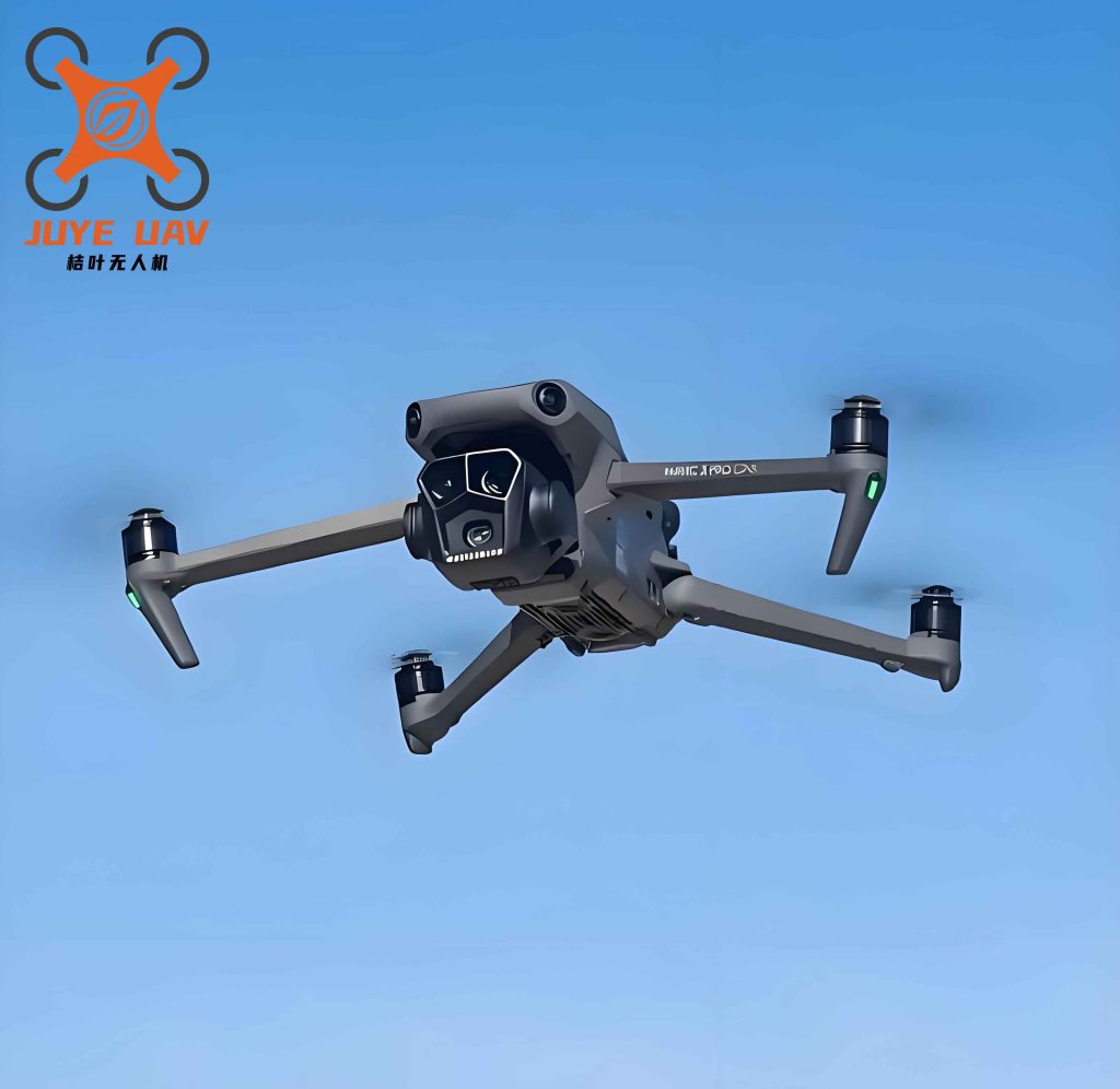
The system also generates automated reports: daily summary of AI-detected hazards, weekly displacement monitoring bulletin, and post-event emergency assessment. Table 5 summarizes the key performance indicators achieved by the system after six months of operation.
| Indicator | Before (Manual) | After (China UAV System) |
|---|---|---|
| Inspection frequency | 1 time/week | 3 times/day (21×) |
| Coverage per inspection | ~30% of slopes (selective) | 100% of slopes (full corridor) |
| Time to detect a new crack | >1 week (next patrol) | <6 hours (same day) |
| Emergency response time (after rain) | >4 hours (mobilize crew) | <30 minutes (UAV launch) |
| Number of hazards found per month | 12 (manual) | 43 (AI + manual verification) |
| False alarm rate (AI) | N/A | 5% (after filtering) |
5. Discussion and Conclusions
The proposed intelligent slope monitoring system, centered on China UAV autonomous inspection, has proven highly effective in addressing the long-standing challenges of large-scale earthwork projects. By automating the inspection process, we achieved a 21-fold increase in monitoring frequency, enabling near-real-time awareness of slope conditions. The oblique photogrammetry 3D models provided comprehensive spatial deformation data, allowing us to detect subtle movements that would be invisible to discrete sensors. The AI defect detection model, trained on a diverse dataset from China UAV imagery, demonstrated >90% precision and recall for cracks and water accumulation, significantly reducing manual inspection workload and human error.
Furthermore, the system’s dual-mode operation—routine daily inspections and emergency rapid response—ensures that both gradual deterioration and sudden failures are captured promptly. The integrated GIS platform transformed fragmented data into a holistic digital twin, empowering managers with intuitive visualization and data-driven decision support. During the six-month pilot, the system identified 256% more hazards than manual inspections, with many detected at early stages before they could escalate into major failures.
This research validates the feasibility and superiority of using China UAV technology for slope safety monitoring in complex infrastructure projects. The technical pathway—automated airfield + oblique photogrammetry + deep learning + GIS—offers a scalable and replicable solution for other domains, such as mining slope management, highway cut slopes, and geological disaster early warning. As China UAV hardware continues to improve (longer flight time, better sensors, edge computing) and AI models become more robust, the system can be extended to real-time deformation monitoring using UAV LiDAR and automated risk prediction using time-series displacement data.
In conclusion, the combination of autonomous China UAV inspection, 3D photogrammetric modeling, and intelligent recognition represents a paradigm shift in engineering safety management—from reactive and periodic to proactive and continuous. We believe this technology will play an increasingly vital role in China’s infrastructure development, enhancing both safety and efficiency while accelerating digital transformation in the civil engineering industry.