
In recent years, the application of unmanned aerial vehicles (UAVs) has expanded dramatically beyond military and industrial spheres into the realm of public spectacle and artistic expression. The most captivating manifestation of this trend is the formation drone light show. This sophisticated system involves coordinating hundreds, sometimes thousands, of drones equipped with LED lights to create dynamic, luminous three-dimensional shapes, logos, and animations in the night sky. While a single drone can be a tool, a synchronized formation drone light show is a breathtaking canvas. However, moving from a single UAV to a coherent, reliable, and safe aerial display presents a significant multi-agent systems challenge. This article analyzes the core technological problems faced in constructing a robust formation drone light show system, drawing parallels from more traditional UAV formation concepts but focusing on the unique demands of entertainment and precision display.
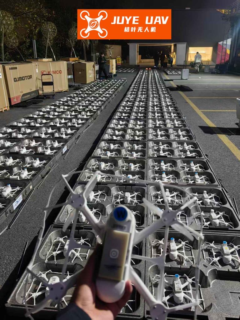
A formation drone light show is not merely a collection of individual drones flying independently; it is an integrated system where each drone acts as a pixel in a massive, mobile, three-dimensional display. The general architecture of such a system typically includes: the drone swarm itself, a ground control station (GCS) for show programming and monitoring, and a robust communication network. The GCS acts as the “conductor,” holding the master timeline and spatial plan for the entire performance.
1. Trajectory Planning and Choreography
The heart of any formation drone light show is its choreography—the precise, time-synchronized paths each drone must follow. Unlike military formations where paths may adapt to threats, a show’s paths are pre-computed artistic and engineering feats that must guarantee collision avoidance and visual perfection. The planning paradigm is primarily centralized and pre-meditated.
1.1 Centralized Pre-Computation by Ground Control
This is the dominant method for formation drone light show. Trajectories for all drones are calculated offline on powerful computers at the GCS before the show. The process involves:
1. Keyframe Design: Artists and engineers define key 3D shapes and transitions.
2. Path Generation: Algorithms assign each drone a smooth trajectory (e.g., using B-splines or polynomial curves) between keyframes, ensuring minimum separation distances are always maintained.
3. Collision Checking: The entire 4D space-time (3D + time) is checked for potential conflicts.
The pre-computed paths are then uploaded to each drone before takeoff.
Advantages:
• Guaranteed Safety: Full offline verification eliminates in-flight collision risks from planning.
• Optimal Visual Quality: Paths can be optimized for smoothness and visual effect.
• Lower Real-Time Computation: Drones essentially “playback” their assigned path.
Disadvantages:
• No Dynamic Adaptation: Cannot react to unforeseen events like a drone failure or sudden wind gust without a pre-programmed contingency.
• High Pre-Processing Load: Planning for thousands of drones is computationally intensive.
• Communication Dependency: Requires flawless initial upload and time-sync.
The core challenge is generating k collision-free trajectories for N drones. A simplified cost function for a single drone’s trajectory can be represented as minimizing jerk or snap for smoothness:
$$ J = \int_{t_0}^{t_f} \left( \frac{d^3 \mathbf{r}(t)}{dt^3} \right)^2 dt $$
where $\mathbf{r}(t)$ is the drone’s position vector over time.
1.2 Real-Time Trajectory Adjustment and Contingency
While the main show is pre-planned, a professional formation drone light show system must have contingency protocols. If a drone fails (e.g., motor fault, low battery), its immediate neighbors should slightly adjust their paths to fill the visual gap or maintain safe distance, moving from a centralized to a distributed adjustment scheme temporarily. This requires onboard real-time path planning capabilities.
| Paradigm | Primary Use Case | Pros | Cons | Computational Load |
|---|---|---|---|---|
| Centralized Pre-Computation (GCS) | Main show choreography | Guaranteed safety & visual perfection, predictable timing | Inflexible to failures, high offline computation | High offline (GCS), Low onboard |
| Distributed Reactive Adjustment | Failure response, obstacle avoidance | Robustness to individual failures, local adaptability | Risk of emergent behavior, complex inter-drone communication needed | Low offline, Medium-High onboard |
2. Formation Geometry and Swarm Topology
The geometry of the swarm is the visible output of the formation drone light show. The design of these formations must consider not only the final picture but also the transitions, aerodynamic and lighting efficiency, and safety.
2.1 Optimal Drone Spacing
Spacing is a critical trade-off:
• Visual Density: Closer drones create a more solid, high-resolution image.
• Safety Margin: Must account for positioning errors (GPS inaccuracy, wind drift) and sudden gusts.
• Aerodynamic Interference: Downwash from one drone can destabilize another if too close.
The optimal 2D grid spacing $d_{opt}$ in a planar formation often follows a rule like:
$$ d_{opt} = \max(d_{safe}, d_{visual}) $$
where $d_{safe}$ is derived from worst-case positioning error and $d_{visual}$ is the desired pixel pitch for the audience.
2.2 Formation Types and Transitions
Common formation types in a formation drone light show include:
• Solid Shapes: Drones are packed to form a continuous surface (e.g., a globe, a logo).
• Outline Shapes: Drones trace the edges of a shape (e.g., a running animal).
• Voxel/Dot Matrix: Drones act as points in a 3D grid, enabling complex 3D animations.
The transition between formations is as important as the formations themselves. Smooth, coordinated motion along calculated trajectories creates the “wow” factor. The choreography software must solve the assignment problem: which drone in Formation A moves to which position in Formation B, minimizing total distance traveled and energy consumed. This can be modeled as a minimum-cost bipartite matching problem.
| Formation Type | Typical Spacing | Visual Impact | Transition Complexity | Redundancy (Gap Filling) |
|---|---|---|---|---|
| Solid / Surface | 1-3 meters | High (bright, detailed images) | High (many intersecting paths) | Difficult (gap is visible) |
| Outline / Vector | 3-10 meters | Medium (recognizable shapes) | Medium | Easier (neighbor can extend path) |
| Voxel / 3D Grid | 2-5 meters | Very High (3D depth) | Very High | Medium |
3. Data Communication and Synchronization
This is arguably the most critical technological backbone. Every drone must know exactly where to be and what color to show at every millisecond. The communication system handles command, control, and timing synchronization.
3.1 Communication Architecture
Two primary architectures exist:
1. Star Topology (Centralized): All drones communicate directly with the GCS. The GCS broadcasts time-synchronized commands (next waypoint, color). This is simple but vulnerable to single-point failure (the GCS radio) and can face bandwidth limitations with very large swarms.
2. Mesh/Relay Topology (Distributed): Drones can relay messages to each other, extending range and robustness. Synchronization can be achieved using protocols like IEEE 1588 Precision Time Protocol (PTP). This is more robust but adds complexity to drone software and power consumption.
For a large-scale formation drone light show, a hybrid approach is often used: a robust, high-bandwidth downlink from GCS (star) for critical commands, coupled with inter-drone communication for health status and relative positioning refinement.
3.2 Message Types and Latency Requirements
The network must prioritize different types of data:
• Synchronization Pulses (Highest Priority): Microsecond-level accuracy is required to keep drones in sync. A delay $\Delta t$ translates directly to a spatial error $\Delta s = v \cdot \Delta t$, where $v$ is drone velocity.
• Emergency Stop / Contingency Commands: Must be received by all drones with near-zero latency.
• Trajectory Updates: If using any real-time adjustment, these require low latency.
• Telemetry Data (Lower Priority): Battery status, health metrics can be sent intermittently.
The required latency $L_{max}$ for formation keeping can be approximated from allowable position error $E_{max}$ and max drone speed $v_{max}$:
$$ L_{max} \leq \frac{E_{max}}{v_{max}} $$
For $E_{max} = 0.1m$ and $v_{max} = 10 m/s$, $L_{max} \leq 10ms$.
| Data Type | Criticality | Required Latency | Bandwidth | Typical Architecture |
|---|---|---|---|---|
| Time Synchronization | Extreme | < 1 ms (jitter) | Low | Broadcast (Star or Mesh Sync) |
| Emergency Command | Extreme | < 50 ms | Very Low | Broadcast (Star) |
| Trajectory Correction | High | < 100 ms | Medium | Unicast/Multicast (Star/Mesh) |
| Telemetry (Health) | Medium | 1-5 s | High (aggregate) | Star to GCS |
4. Positioning and Navigation
Accurate localization is fundamental. While consumer drones use GNSS (like GPS), its accuracy (1-3 meters) is insufficient for tight formations. Therefore, formation drone light show systems employ augmentation techniques.
4.1 RTK-GNSS (Real-Time Kinematic)
This is the standard for professional shows. A fixed base station on the ground provides correction data to the drones, enabling centimeter-level accuracy. The position solution for a drone using RTK corrections can be modeled as solving carrier-phase ambiguity integers $\mathbf{N}$:
$$ \Phi = \rho + c(dt – dT) + T – I + \lambda N + \epsilon $$
where $\Phi$ is carrier phase measurement, $\rho$ is true range, $c$ is speed of light, $dt, dT$ are clock errors, $T, I$ are atmospheric delays, $\lambda$ is wavelength, and $\epsilon$ is noise. RTK resolves $N$ to get precise $\rho$.
4.2 Relative Positioning and Altitude Hold
Even with RTK, relative positioning between drones is crucial. This can be enhanced using:
• Ultra-Wideband (UWB): For short-range, high-precision inter-drone ranging.
• Visual/LED Tracking: Onboard cameras recognizing patterns or LEDs on neighboring drones.
Altitude is typically maintained via barometric sensors fused with GNSS data, as GNSS altitude is less accurate.
5. Future Trends and Conclusion
The technology behind formation drone light show is rapidly evolving. Key future trends include:
1. Increased Autonomy and Robustness: Moving from pure playback to systems that can dynamically re-plan shows in case of failures, adapting formations in real-time to maintain the visual integrity of the performance.
2. Advanced Communication Protocols: Adoption of 5G NR (New Radio) slices could provide ultra-reliable low-latency communication (URLLC) for critical commands and high bandwidth for telemetry, managing thousands of connections simultaneously.
3. More Complex Aerial Intelligence: Incorporating onboard sensing (LiDAR, vision) not just for safety but for interactive shows that respond to audience movement, music, or environmental elements like wind, creating a truly adaptive formation drone light show.
4. Swarm Intelligence Algorithms: Implementing bio-inspired flocking algorithms for smoother, more organic-looking transitions and emergent behaviors, while keeping the core choreography under central creative control.
In conclusion, constructing a reliable and spectacular formation drone light show is a multidisciplinary challenge that sits at the intersection of robotics, control theory, wireless communication, and computer graphics. The core problems of precise trajectory planning, robust formation geometry, ultra-reliable low-latency communication, and centimeter-accurate synchronization are being solved through a combination of centralized pre-planning and distributed real-time intelligence. As these technologies mature, the scale, complexity, and interactive potential of these luminous aerial ballets will continue to grow, pushing the boundaries of what is possible in aerial artistry and coordinated swarm robotics.