
As fire and rescue operations evolve to address complex disasters, the integration of unmanned aerial vehicles (UAVs), specifically fire UAVs, has become a transformative force. In this article, I will explore the multifaceted role of fire UAVs in enhancing rescue efficiency, safety, and decision-making. The fire UAV, a specialized drone designed for firefighting and emergency response, offers unparalleled capabilities in surveillance, communication, and direct intervention. Drawing from technical insights and practical applications, this analysis delves into the classification, parameters, operational use, deployment models, and challenges of fire UAVs, emphasizing their growing importance in the “all-hazard, big emergency” rescue paradigm.
The proliferation of fire UAV technology stems from advancements in hardware materials, software algorithms, and energy systems, which have propelled UAVs into diverse sectors like agriculture, public safety, and transportation. In fire rescue, the fire UAV is not merely a tool but a strategic asset that reduces risks to human life and improves operational outcomes. This article aims to provide a detailed examination, enriched with tables and formulas, to underscore the criticality of fire UAVs in modern rescue workflows.
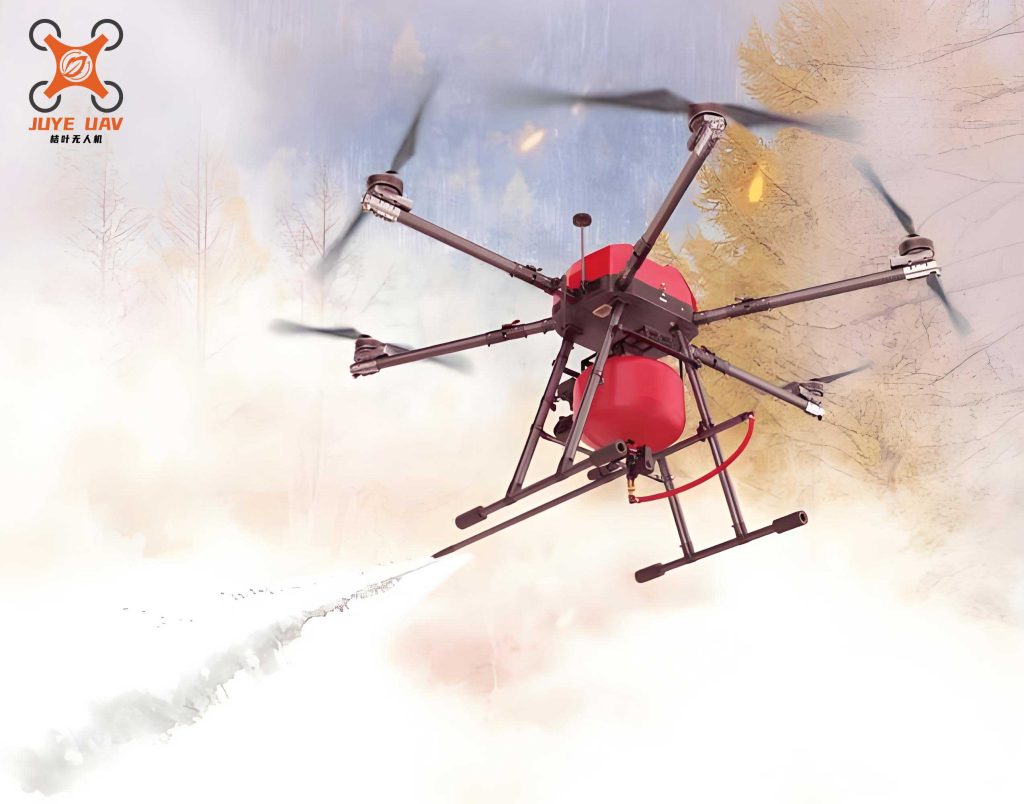
To understand the fire UAV’s potential, we must first define its scope. A fire UAV refers to an unmanned aircraft system equipped with payloads and functionalities tailored for fire suppression, hazard detection, and rescue support. Unlike consumer drones, fire UAVs are built to withstand harsh environments, such as high temperatures, strong winds, and corrosive atmospheres. The core value of a fire UAV lies in its ability to access inaccessible areas, provide real-time data, and execute tasks that would otherwise endanger personnel.
The classification of fire UAVs is essential for selecting the right platform for specific missions. Based on criteria like flight platform, purpose, size, altitude, and operational radius, fire UAVs can be categorized as shown in Table 1. This classification helps rescue teams match UAV capabilities to mission requirements, ensuring optimal performance. For instance, multi-rotor fire UAVs are favored for their vertical take-off and landing (VTOL) capabilities, making them ideal for urban fire scenes, while fixed-wing fire UAVs offer longer endurance for large-scale disasters like forest fires.
| Category | Types | Typical Specifications | Common Uses in Fire Rescue |
|---|---|---|---|
| Flight Platform | Multi-rotor, Fixed-wing, Hybrid | VTOL for multi-rotor; long-range for fixed-wing | Close-range surveillance, payload delivery |
| Purpose | Surveillance, Delivery, Communication, Detection | Custom payloads (cameras, sensors, speakers) | Fire assessment, equipment transport |
| Size | Micro, Mini, Small, Medium, Large | Weight from <1 kg to >150 kg | Portable units for rapid deployment |
| Flight Altitude | Low (<500 m), Medium (500-2000 m), High (>2000 m) | Limited by regulations and battery life | Low-altitude mapping and monitoring |
| Operational Radius | Short-range (<10 km), Medium-range (10-50 km), Long-range (>50 km) | Dependent on communication links | Local incident response, wide-area search |
Key parameters of a fire UAV directly influence its effectiveness in rescue scenarios. Understanding these parameters through quantitative models is crucial. For example, the endurance of a fire UAV, often a limiting factor, can be expressed using the formula for battery-powered systems: $$ T = \frac{C \cdot V}{P} $$ where \( T \) is the flight time in hours, \( C \) is the battery capacity in ampere-hours (Ah), \( V \) is the voltage in volts (V), and \( P \) is the average power consumption in watts (W). This formula highlights how advancements in battery technology, such as high-density lithium-polymer cells, can extend the operational window of a fire UAV. Similarly, the payload capacity of a fire UAV determines the types of rescue equipment it can carry, impacting missions like aerial delivery of life-saving gear. The relationship between payload and flight time can be approximated by: $$ T_{\text{payload}} = T_{\text{empty}} – k \cdot m $$ where \( T_{\text{payload}} \) is the flight time with payload, \( T_{\text{empty}} \) is the flight time without payload, \( k \) is a constant dependent on UAV design, and \( m \) is the payload mass in kilograms. This linear reduction underscores the trade-offs in fire UAV configuration.
Environmental resilience is another critical parameter for fire UAVs. Operating in conditions like high winds, rain, or extreme temperatures requires robust engineering. The wind resistance of a fire UAV can be modeled using the Beaufort scale, where a UAV rated for Level 8 winds (62-74 km/h) can withstand gusts common in firestorms. However, rain penetration often necessitates waterproofing, which adds weight and cost. The probability of successful flight in adverse weather can be estimated as: $$ P_{\text{success}} = e^{-\lambda \cdot W} $$ where \( \lambda \) is a failure rate coefficient and \( W \) is the weather severity index. Such models aid in risk assessment before deploying a fire UAV.
The applications of fire UAVs in rescue operations are diverse and expanding. I will detail each application area, demonstrating how fire UAVs enhance situational awareness and operational efficiency. These applications are summarized in Table 2, which maps fire UAV functions to specific rescue tasks and outcomes. The fire UAV’s versatility allows it to serve as eyes in the sky, a communication relay, and even an active participant in life-saving actions.
| Application Area | Specific Tasks | Fire UAV Payloads Used | Impact on Rescue Outcomes |
|---|---|---|---|
| Assisted Decision-Making | Fire scene reconnaissance, hazard monitoring, real-time video streaming | High-resolution cameras, thermal imaging, gas sensors | Reduces response time, improves strategy accuracy |
| Emergency Command Delivery | Broadcasting evacuation orders, safety alerts via loudspeakers | Megaphone modules, LED displays | Enhances public safety during crises |
| Direct Rescue Missions | Airdropping life jackets, ropes, medical kits; detecting toxic leaks | Payload release mechanisms, environmental sensors | Saves lives in inaccessible areas, minimizes exposure |
| Communication Relay | Extending radio signals, establishing ad-hoc networks in dead zones | Signal repeaters, Wi-Fi hotspots | Ensures coordination among rescue teams |
| Terrain and Resource Mapping | Surveying water sources, road conditions, hazard zones | GIS mapping software, LIDAR sensors | Optimizes resource allocation and planning |
In assisted decision-making, the fire UAV provides a bird’s-eye view of disaster sites, enabling commanders to assess fire spread, structural integrity, and victim locations. For instance, during building collapses, a fire UAV equipped with thermal cameras can detect heat signatures of trapped individuals, guiding extraction efforts. The data collected by a fire UAV can be processed using machine learning algorithms to predict fire behavior, expressed as: $$ \frac{\partial F}{\partial t} = \alpha \cdot \nabla^2 F + \beta \cdot S $$ where \( F \) is the fire intensity, \( t \) is time, \( \alpha \) is diffusion coefficient, \( \nabla^2 \) is the Laplacian operator for spread, and \( \beta \cdot S \) represents source terms like fuel load. This equation, when fed with real-time fire UAV data, improves forecast accuracy.
For emergency command delivery, the fire UAV acts as a mobile announcement system. In events like chemical spills or flash floods, a fire UAV with a loudspeaker can broadcast instructions to evacuate, reducing panic and directing crowds to safety. The sound pressure level (SPL) of a fire UAV’s speaker can be calculated using: $$ \text{SPL} = 20 \log_{10}\left(\frac{p}{p_0}\right) $$ where \( p \) is the sound pressure and \( p_0 \) is the reference pressure. Optimizing SPL ensures audibility over disaster noise, a key factor in effective communication.
Direct rescue missions showcase the fire UAV’s ability to perform physical tasks. In water rescues, a fire UAV can drop inflatable rafts or life rings to drowning victims, with drop accuracy influenced by wind drift and UAV stability. The trajectory of a dropped payload can be modeled as: $$ y(t) = y_0 + v_{0y} t – \frac{1}{2} g t^2 $$ where \( y(t) \) is the vertical position, \( y_0 \) is release height, \( v_{0y} \) is initial vertical velocity, and \( g \) is gravity. For hazardous material detection, fire UAVs equipped with spectrometers can measure gas concentrations, with detection limits given by: $$ C_{\text{min}} = \frac{k \cdot N}{S \cdot \sqrt{t}} $$ where \( C_{\text{min}} \) is the minimum detectable concentration, \( k \) is a constant, \( N \) is noise level, \( S \) is sensor sensitivity, and \( t \) is sampling time. This allows fire UAVs to map contamination plumes safely.
Communication relay is vital in large-scale disasters where infrastructure is damaged. A fire UAV serving as an aerial base station can extend radio ranges by several kilometers, with the link budget expressed as: $$ P_r = P_t + G_t + G_r – L $$ where \( P_r \) is received power, \( P_t \) is transmitted power, \( G_t \) and \( G_r \) are antenna gains, and \( L \) is path loss. Deploying multiple fire UAVs in a mesh network can create resilient communication grids, ensuring uninterrupted coordination.
Terrain mapping with fire UAVs aids in pre-incident planning and real-time navigation. Using photogrammetry, a fire UAV can generate 3D models of disaster zones, with accuracy dependent on ground sampling distance (GSD): $$ \text{GSD} = \frac{H \cdot s}{f} $$ where \( H \) is flight altitude, \( s \) is sensor pixel size, and \( f \) is focal length. These models help identify access routes and resource locations, streamlining logistics.
The deployment of fire UAVs across different levels of rescue agencies follows a tiered model, as outlined in Table 3. This structured approach ensures that fire UAV resources are allocated based on operational scope and needs, maximizing their impact. From local fire stations to national command centers, each tier leverages fire UAV capabilities differently, but all contribute to a cohesive rescue ecosystem.
| Agency Level | Primary Roles | Recommended Fire UAV Specifications | Deployment Strategy |
|---|---|---|---|
| Local Stations (Grassroots) | Initial response, scene assessment, basic delivery | Lightweight multi-rotors, battery-powered, modular payloads | One primary unit with few backups; rapid deployment |
| Regional Commands (Brigade) | Coordinated operations, hazard detection, cross-area support | Medium-endurance UAVs, hybrid power systems, advanced sensors | Multiple units with limited backups; specialized missions |
| National Headquarters (Headquarters) | Strategic support, technology development, large-scale disasters | High-performance UAVs, fuel-powered, swarm capabilities | Extensive fleet with ample backups; multi-UAV协作 |
At the local level, fire UAVs are tools for immediate action. A fire station might use a micro fire UAV for quick reconnaissance, adhering to regulations that often exempt sub-7 kg drones from complex licensing. The cost-benefit analysis for such deployments can be modeled as: $$ \text{ROI} = \frac{B – C}{C} $$ where ROI is return on investment, \( B \) is benefits like reduced casualties, and \( C \) is costs including UAV purchase and training. Studies show that early fire UAV deployment lowers property damage by up to 30%.
Regional commands require fire UAVs with greater endurance and payload diversity. For example, a brigade might deploy a fire UAV with chemical sensors to monitor industrial fires, transmitting data to incident commanders. The data throughput of such a fire UAV system can be calculated using Shannon’s theorem: $$ C = B \log_2(1 + \text{SNR}) $$ where \( C \) is channel capacity in bits per second, \( B \) is bandwidth, and SNR is signal-to-noise ratio. This ensures reliable video and sensor data feeds.
National headquarters focus on innovation and large-scale integration. Here, fire UAV swarms—multiple drones operating collaboratively—can cover vast areas, with coordination algorithms based on flocking models: $$ \vec{v}_i(t+1) = \vec{v}_i(t) + \sum_{j \neq i} \left( \vec{f}_{\text{align}} + \vec{f}_{\text{coh}} + \vec{f}_{\text{sep}} \right) $$ where \( \vec{v}_i \) is the velocity of UAV \( i \), and the forces align, cohere, and separate the swarm. This enables synchronized mapping and response in catastrophes like earthquakes.
Despite their advantages, fire UAVs face several constraints that hinder widespread adoption. These constraints, summarized in Table 4, span technical, human, regulatory, and experiential domains. Addressing these challenges is essential to fully harness the potential of fire UAVs in rescue operations. Each constraint interplays with others, creating a complex landscape for implementation.
| Constraint Category | Specific Issues | Impact on Fire UAV Effectiveness | Potential Mitigation Strategies |
|---|---|---|---|
| Technical Limitations | Short battery life, limited payload, vulnerability to weather | Reduces operational time and scope | Develop hybrid power systems, enhance materials |
| Human Factors | Operator skill gaps, lack of standardized training | Increases risk of accidents and misuse | Implement certification programs, simulators |
| Regulatory Barriers | Flight restrictions, licensing requirements, airspace conflicts | Delays deployment and limits areas of use | Advocate for emergency waivers, policy reforms |
| Experiential Gaps | Insufficient case studies, undefined protocols | Leads to inconsistent practices and errors | Build databases of best practices, conduct drills |
Technically, the endurance of a fire UAV remains a bottleneck. Even with lithium-polymer batteries, flight times rarely exceed 60 minutes, which may be inadequate for prolonged incidents. Research into alternative energy sources, such hydrogen fuel cells, offers promise, with energy density given by: $$ E = \frac{\Delta H}{M} $$ where \( E \) is specific energy, \( \Delta H \) is enthalpy of combustion, and \( M \) is molar mass. Hydrogen-powered fire UAVs could triple endurance, but they pose storage and safety challenges.
Human factors are equally critical. Operating a fire UAV requires spatial awareness, multitasking, and emergency judgment, skills that vary among rescuers. The learning curve for fire UAV pilots can be modeled with the power law of practice: $$ T = a \cdot N^{-b} $$ where \( T \) is performance time, \( N \) is number of trials, and \( a \) and \( b \) are constants. Standardized training programs, incorporating virtual reality simulations, can accelerate proficiency and reduce errors.
Regulatory hurdles stem from aviation authorities’ concerns over airspace safety. In many regions, fire UAV flights beyond visual line-of-sight (BVLOS) require special permits, which can slow emergency responses. The probability of obtaining timely clearance is often low during crises. Streamlining processes through pre-approved emergency corridors, defined by geographic coordinates, could mitigate this. The coverage area of such a corridor can be calculated as: $$ A = \pi R^2 $$ where \( R \) is the radius from the incident epicenter, allowing fire UAVs to operate freely within.
Experiential gaps arise from the relative novelty of fire UAVs in rescue. Unlike traditional equipment, few documented protocols exist for scenarios like UAV-based victim extraction. Building a knowledge repository through after-action reviews and international collaborations can fill this void. The effectiveness of such knowledge transfer can be quantified using: $$ K_{\text{gain}} = \frac{I_{\text{post}} – I_{\text{pre}}}{I_{\text{pre}}} $$ where \( I \) is an incident performance index.
Looking ahead, the future of fire UAVs lies in integration with other technologies like artificial intelligence (AI) and the Internet of Things (IoT). AI-powered fire UAVs could autonomously identify hazards using convolutional neural networks: $$ y = \sigma(W \cdot x + b) $$ where \( y \) is the output classification, \( \sigma \) is an activation function, \( W \) are weights, \( x \) is input data from sensors, and \( b \) is bias. This would enable real-time decision support without human intervention. Similarly, IoT sensors on the ground could relay data to fire UAVs, creating a dynamic response network.
In conclusion, the fire UAV represents a paradigm shift in fire and rescue operations, offering capabilities that enhance safety, efficiency, and effectiveness. From detailed parameter analysis to tiered deployment models, this article has explored the multifaceted role of fire UAVs, emphasizing their applications in decision-making, command delivery, direct rescue, communication, and mapping. While constraints like technical limits and regulatory barriers persist, ongoing advancements in energy, materials, and policy promise to overcome these hurdles. As fire UAV technology matures, it will undoubtedly become a cornerstone of modern rescue strategies, saving lives and protecting communities in an increasingly complex world. The journey toward standardized, ubiquitous fire UAV use is underway, and its success will depend on continued innovation, training, and collaboration across the rescue sector.