Live aerial photography using camera drones provides critical real-time situational awareness for maritime test operations. Unmanned Aerial Vehicles (UAVs) offer cost-effective deployment, exceptional mobility, and beyond-visual-line-of-sight control capabilities. Equipped with specialized payloads, these camera UAVs deliver high-resolution, large-scale imagery with superior timeliness, making them indispensable for geographic surveys, dynamic target tracking, and rapid imaging acquisition across defense, security, and scientific domains. Ship-based camera drone operations fundamentally differ from terrestrial deployments due to dynamic maritime environments, demanding specialized platform selection and operational protocols.
Operational Characteristics of Ship-Based Camera Drones
Selecting appropriate camera UAV platforms for maritime operations requires addressing three critical constraints:
- Vertical Takeoff and Landing (VTOL): Limited deck space necessitates VTOL capabilities, eliminating complex launch/recovery systems. Multi-rotor camera drones excel in confined areas like aft decks.
- Flight Control Redundancy: Industrial-grade flight controllers with electromagnetic compatibility (EMC) resilience are essential to counter shipboard magnetic interference and radar/radio frequency noise. Dual-GPS differential heading systems provide compass-independent navigation.
- Environmental Hardening: Systems require IP54-rated protection against humidity (≥80%), salt spray, and sustained winds ≥15 m/s. Corrosion-resistant materials and waterproofing ensure operational reliability.
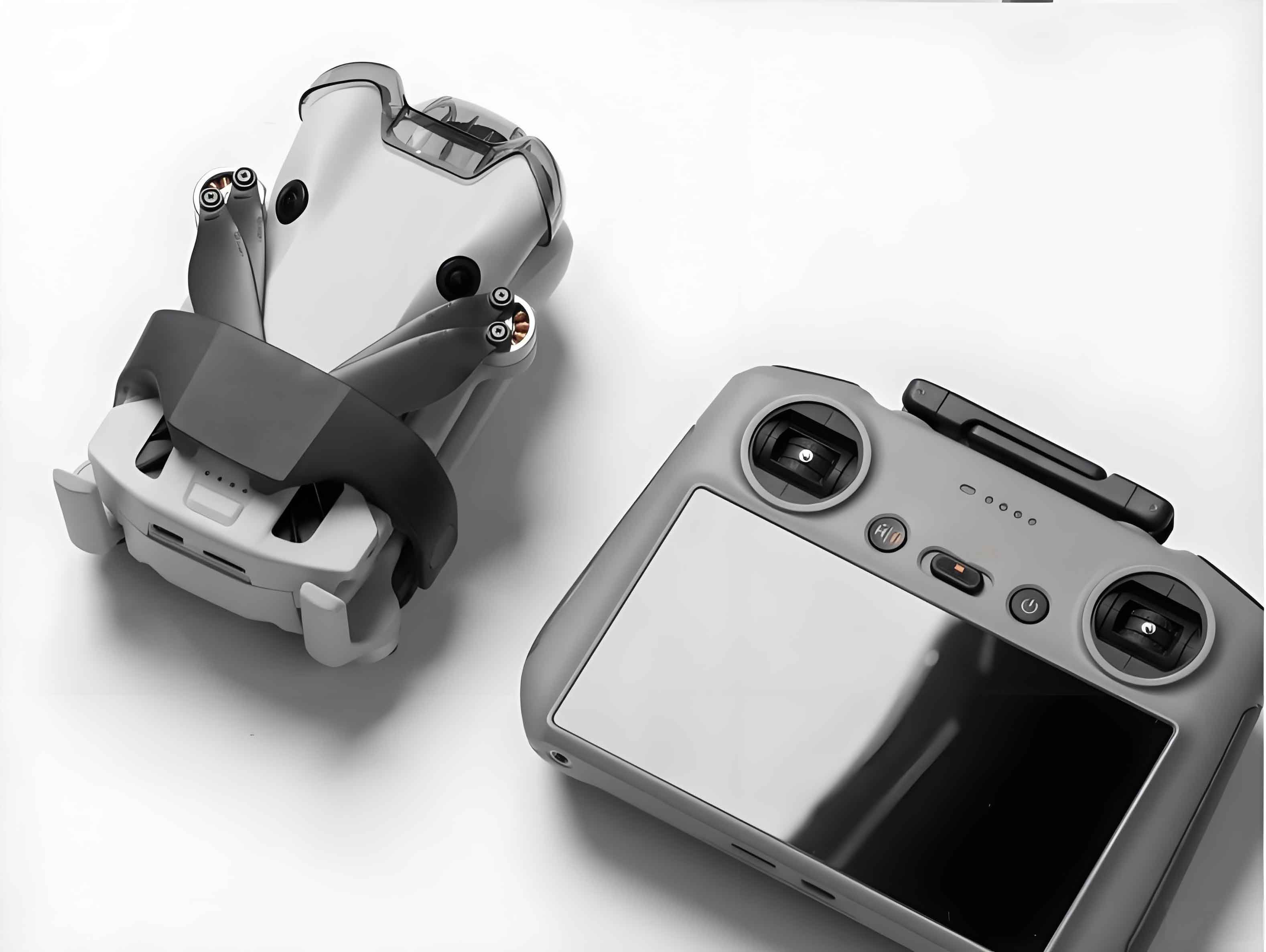
The camera drone system architecture integrates three subsystems:
- Rotorcraft Platform: Features structural components, propulsion modules, dual GPS/GLONASS/BeiDou navigation, IMU sensors, and flotation devices for water recovery. Operational modes include auto takeoff/landing, position hold, follow-me, and loss-of-signal hover.
- Imaging Payload: Combines 4K optical zoom cameras with 3-axis active gimbals (pitch ±90°, roll ±30°, yaw 360°) counteracting UAV vibrations at 200Hz frequency.
- Control System: Comprises ground control stations (GCS) for mission planning and handheld remotes with real-time telemetry display (position, attitude, battery, link quality).
Critical Factors for Maritime Camera UAV Operations
Five operational vectors determine mission success for ship-based camera drones:
Environmental Scheduling
Deck motion (roll/pitch/heave ≤5°) and relative wind vectors dictate launch windows. The apparent wind velocity ($W_a$) derives from true wind ($W_t$) and ship velocity ($V_s$) vectors:
$$ \overrightarrow{W_a} = \overrightarrow{W_t} – \overrightarrow{V_s} $$
Optimal operations use 3-4 wave cycle lulls (5-37s calm periods) for takeoff/landing when deck motion amplitude is minimized.
Field-of-View Optimization
Camera drone positioning avoids ship superstructures and sun glare while maximizing coverage. At 200m altitude and 900m standoff distance, a camera with 50°×28° FoV covers:
$$ \text{Vertical Coverage} = 2 \times 200 \times \tan(14^\circ) \approx 112\text{m} $$
$$ \text{Horizontal Coverage} = 2 \times 900 \times \tan(25^\circ) \approx 839\text{m} $$
Cinematographic Techniques
| Technique | Application | Maritime Effectiveness |
|---|---|---|
| Tracking Shot | Following moving targets | Primary (80% usage) |
| Vertical Dolly | Altitude transitions | Secondary (15% usage) |
| Orbiting | Target-centered circles | Tertiary (4% usage) |
| Linear Dolly | Straight-line motion | Minimal (1% usage) |
Link Management
Frequency-agile datalinks (2.4/5.8GHz dual-band) mitigate electromagnetic interference from ship systems. Spectrum analyzers pre-identify clear channels, prioritizing concentrated signal energy over bandwidth:
$$ \text{Link Margin} = P_{tx} – L_{fs} – L_{atm} + G_{rx} > 20\text{dB} $$
where $P_{tx}$ is transmit power, $L_{fs}$ free-space loss, $L_{atm}$ atmospheric attenuation, and $G_{rx}$ receiver gain.
Navigation Configuration
Magnetic compasses remain disabled during shipboard operations. Flight modes default to attitude-based navigation with “hover-on-fail” protocols. Return-to-home functions require dynamic coordinate updates to accommodate ship movement.
Safety Analysis for Ship-Based Camera Drone Operations
A fuzzy comprehensive evaluation model assesses maritime camera UAV operational safety under Sea State 3 (wave height 0.5-1.25m), 10m/s headwinds, and 10kt ship speed:
Evaluation Hierarchy
| Tier-1 Factors ($w_i$) | Tier-2 Factors ($w_{ij}$) | Membership Grades |
|---|---|---|
| UAV System (0.3) | Wind Resistance (0.15) | V3:0.3, V4:0.5, V5:0.2 |
| Navigation Accuracy (0.50) | V2:0.2, V3:0.5, V4:0.2, V5:0.1 | |
| EMC Hardening (0.15) | V2:0.2, V3:0.2, V4:0.5, V5:0.1 | |
| Water Recovery (0.20) | V2:0.3, V3:0.3, V4:0.2, V5:0.2 | |
| Ship Platform (0.2) | Deck Space (0.30) | V2:0.1, V3:0.3, V4:0.5, V5:0.1 |
| Motion Characteristics (0.20) | V2:0.3, V3:0.5, V4:0.2 | |
| Support Systems (0.50) | V3:0.3, V4:0.5, V5:0.2 | |
| Marine Environment (0.3) | Wind/Waves (0.35) | V1:0.1, V2:0.2, V3:0.3, V4:0.2, V5:0.2 |
| Visibility (0.50) | V1:0.1, V2:0.15, V3:0.5, V4:0.15, V5:0.1 | |
| Humidity (0.15) | V2:0.2, V3:0.4, V4:0.2, V5:0.2 | |
| Human Factors (0.2) | Operator Skill (0.60) | V2:0.2, V3:0.5, V4:0.2, V5:0.1 |
| Procedural Compliance (0.40) | V2:0.2, V3:0.5, V4:0.2, V5:0.1 |
Fuzzy Evaluation Matrix
For UAV System ($b_1$):
$$ \mathbf{R_1} = \begin{bmatrix}
0 & 0 & 0.3 & 0.5 & 0.2 \\
0 & 0.2 & 0.5 & 0.2 & 0.1 \\
0 & 0.2 & 0.2 & 0.5 & 0.1 \\
0 & 0.3 & 0.3 & 0.2 & 0.2
\end{bmatrix} $$
$$ \mathbf{B_1} = \mathbf{w_{1j}} \cdot \mathbf{R_1} = [0, 0.19, 0.385, 0.29, 0.135] $$
Composite safety vector for all factors ($w_i$ = [0.3, 0.2, 0.3, 0.2]):
$$ \mathbf{B} = \sum_{i=1}^{4} w_i \mathbf{B_i} = [0.0255, 0.1675, 0.4080, 0.2675, 0.1315] $$
Quantitative Safety Index
With evaluation set $\mathbf{V} = [0.1, 0.3, 0.5, 0.7, 0.9]$:
$$ T = \sum_{k=1}^{5} b_k \cdot v_k = 0.5624 $$
This positions operational safety between “Marginal” (0.5) and “Satisfactory” (0.7), aligning with naval helicopter operational limits at Sea State 3. Camera drone deployment requires strict wind thresholds ≤12m/s and specialized crew training.
Conclusion
Ship-based camera UAVs significantly enhance test visualization through dynamic aerial monitoring. The fuzzy safety model confirms operational viability under Sea State 3 conditions when integrating VTOL platforms, EMC-hardened systems, and optimized cinematographic protocols. Multi-rotor camera drones demonstrate particular effectiveness in tracking shots and vertical dolly maneuvers at 100-200m altitudes. As autonomy and ship-drone integration advance, these camera UAV systems will become indispensable for maritime test documentation, real-time decision support, and mission analytics across defense and scientific applications.