
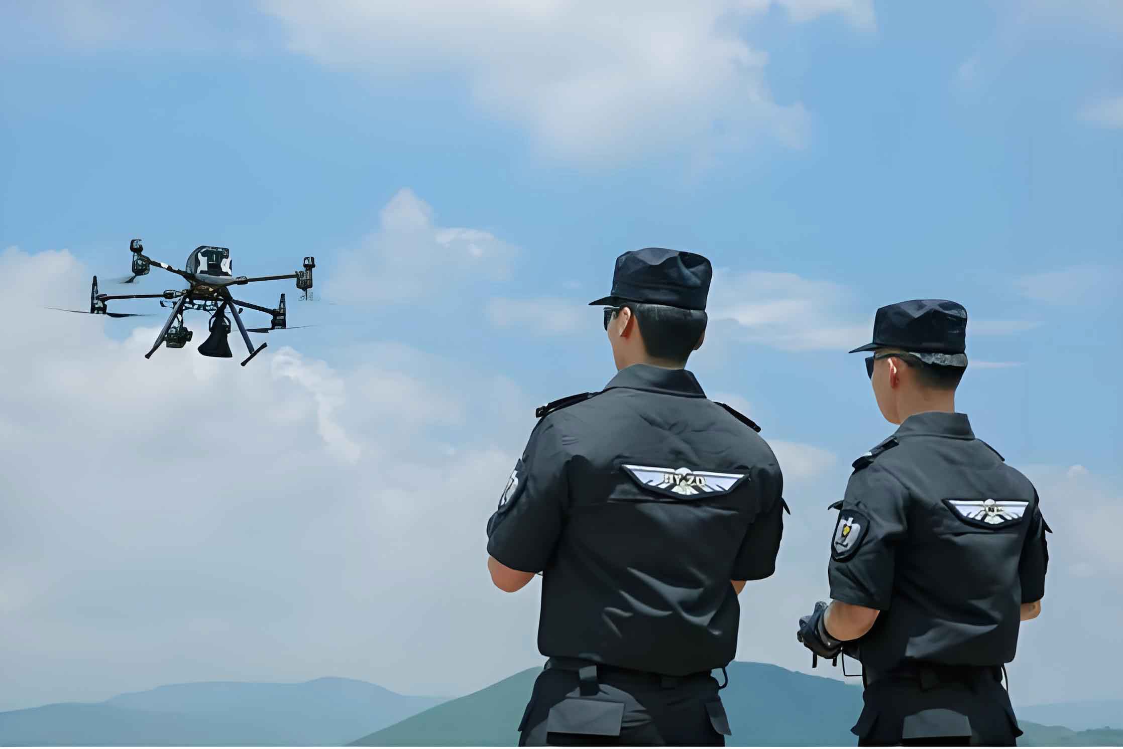
In the current era of rapid police modernization and technological advancement, the application of police Unmanned Aerial Vehicles (UAVs) in mountainous regions has become increasingly prominent and vital. Traditional policing equipment often faces significant limitations within the complex and variable topography and climate of mountain ranges. The emergence of the police UAV has effectively filled this operational gap. With their inherent flexibility and mobility, police UAVs have become indispensable tools for executing critical tasks such as search and rescue (SAR) in these challenging environments. Their efficient response speed and adaptability not only enhance the overall efficiency and safety of police operations but also offer unique advantages in handling emergencies. By deploying advanced sensor payloads, a police UAV can gather and transmit real-time environmental data, providing comprehensive informational support that optimizes the police decision-making process. Therefore, an in-depth study of police UAV applications in mountainous settings holds significant importance for advancing police modernization and elevating emergency response capabilities.
Primary Mission Typologies for Mountainous Operations
The mission spectrum for police UAVs in mountainous areas is diverse, encompassing roles that leverage their aerial perspective and technological payloads. The most prevalent mission types include search and rescue, fugitive tracking, and surveillance patrols.
Search and Rescue (SAR)
The importance of SAR operations in mountainous and disaster-stricken areas is self-evident. These regions are characterized by complex terrain and harsh climatic conditions, which pose immense challenges to traditional ground-based rescue efforts. The rapid response capability and wide-area coverage of a police UAV make it a key asset in such incidents. In SAR missions, a police UAV equipped with various sensors can conduct real-time situation monitoring, detect human presence, and provide detailed situational data. By relaying live images and video, it assists decision-makers in formulating more effective rescue strategies. Furthermore, police UAVs can be configured to deliver essential supplies such as medical equipment or communication devices to stranded individuals, providing basic first aid and life support, thereby reducing casualty risks during rescue operations and playing a crucial role in safeguarding lives and property.
When deploying a police UAV for mountain SAR, several operational foci are critical: observing the terrain environment, precisely identifying and marking targets, perceiving environmental changes, planning effective search paths, monitoring personnel locations, identifying distress signals, promptly sharing data with the rescue team, and managing emergent situations. Through these measures, the police UAV provides vital support, enhancing rescue efficiency and ensuring the safety of those in peril.
Fugitive Search and Apprehension
The police UAV plays an immensely valuable role in locating fugitives within mountainous environments. In recent years, due to the enhanced counter-surveillance capabilities of criminals, many tend to hide in remote mountainous areas to evade capture. The vast, open nature of mountain terrain is disadvantageous for traditional police search methods. Police UAVs, equipped with thermal imaging, infrared technology, and high-resolution cameras, provide not only an elevated, panoramic surveillance capability but also enable all-weather search operations across complex landscapes. They assist law enforcement in effectively detecting a fugitive’s position, monitoring their movements, and ultimately pinpointing their hideout.
Surveillance and Patrol
Police UAVs enable efficient monitoring and patrol of mountainous regions, supplying police forces with data for border control and criminal activity surveillance. Their high efficiency and low-risk profile increase operational productivity while reducing the dangers faced by officers in these hazardous environments. Additionally, using high-definition camera systems, a police UAV can rapidly and accurately capture subtle changes in vegetation or terrain, facilitating the early detection of potential natural disaster risks or anomalous activities.
During surveillance patrols, attention to detail is paramount. Operators must be vigilant in reporting abnormal situations, including but not limited to suspicious individual behavior, unusual traffic flow or loitering, signs of potential illegal activity, or sudden incidents. It is essential to document all critical information—such as time, location, and descriptions of involved subjects—and communicate it promptly to the command center or relevant departments to enable necessary actions or further investigation.
Operational Challenges in Mountainous Environments
The deployment of police UAVs in mountainous settings confronts multiple challenges including complex terrain, volatile weather, compromised communications, and limited endurance. These factors significantly increase operational difficulty and risk.
Complex Topography
Mountainous terrain is inherently complex and rugged, featuring steep peaks, deep valleys, gorges, and cliffs. Unlike flat, open areas, mountains often contain natural wind channels or unpredictable air currents and lack clear landmarks. This poses substantial challenges for UAV flight and navigation, potentially leading to failures in navigation and positioning systems and increasing the risk of collision with obstacles or catastrophic failure.
Variable Climatic Conditions
Mountain weather is notoriously unpredictable. Extreme conditions such as strong winds, dense fog, and heavy rainfall severely test a police UAV’s stability. Sudden gusts can disrupt its flight trajectory, while fog and precipitation directly impair visibility and degrade sensor performance. These adverse conditions not only restrict the practical utility of UAVs in mountains but also substantially reduce the accuracy and reliability of data collection, impacting mission effectiveness and operational efficiency.
Poor Communication Environment
Within the complex topography of mountains, UAV navigation, positioning, and communication face significant hurdles. The communication environment is often suboptimal, suffering from incomplete signal coverage or interference. This can cause interruptions or delays in the link between the police UAV and its ground control station (GCS), affecting real-time control and data transmission. Furthermore, infrastructure like high-voltage towers and power lines common in some mountain areas can interfere with communication and video transmission links.
Endurance and Logistics Constraints
UAV endurance is a critical factor influencing mission execution and efficiency. The high altitude, variable climate, and wind speeds characteristic of mountain environments all impact energy consumption, often requiring longer flight times to cover vast areas or complete specific tasks. Compounding this, the complex terrain and poor accessibility of mountains can make it difficult to locate suitable recharging stations or energy replenishment points, further affecting the police UAV’s operational persistence.
Strategic Solutions and Technological Countermeasures
Addressing the challenges of mountain operations requires focused consideration of UAV selection and configuration, path planning technology, multi-UAV collaboration, and team structure. These elements are crucial for ensuring the safe and efficient operation of police UAVs in complex mountainous settings.
UAV Selection and Configuration
Currently, the primary types of police UAVs in service are fixed-wing and multi-rotor platforms, each with distinct advantages as summarized in the table below.
| Feature | Fixed-Wing Police UAV | Multi-Rotor Police UAV |
|---|---|---|
| Primary Strength | Long-range, wide-area rapid search | Operations in confined, complex terrain |
| Endurance & Speed | High endurance, faster flight speed | Lower endurance relative to fixed-wing, slower speed |
| Maneuverability | Requires runway or launcher for take-off/landing; limited low-speed maneuverability | Vertical Take-Off and Landing (VTOL), excellent hover capability, high maneuverability at low speeds |
| Ideal Use Case | Initial large-area sweep, mapping, linear inspections (e.g., pipelines, borders) | Close-quarters inspection, stationary surveillance, precision delivery, operations in forests or deep valleys |
Selection must be based on specific mission requirements and terrain characteristics, balancing the broad coverage of fixed-wing platforms with the flexibility of multi-rotor systems. An optimal police UAV fleet for mountains often involves a mix of both types.
Beyond platform type, configuration is key. The chosen police UAV must demonstrate stable flight performance in恶劣 weather and complex terrain. It should be equipped with advanced sensors—such as high-definition zoom cameras, thermal imagers, infrared cameras, and Light Detection and Ranging (LiDAR)—enabling data fusion to enhance monitoring and target identification capabilities in challenging environments. Furthermore, the platform must possess extended endurance to meet prolonged mission demands. Communication system robustness is equally critical; UAVs equipped with high-gain antennas and signal amplifiers ensure stronger, more stable transmission links, maintaining crucial contact with command centers for timely data relay and strategic coordination.
Optimized Path Planning
Advanced path planning is essential for mountainous operations. It relies on terrain perception and obstacle avoidance technologies, utilizing sensors like LiDAR and cameras to perceive the surrounding environment in real-time and avoid terrain obstacles such as cliffs and trees. Path planning algorithms must account for multiple factors including mission priority, terrain features, and meteorological conditions, allowing the police UAV to autonomously adjust its flight path in response to environmental changes.
For instance, LiDAR sensors onboard a police UAV can scan the environment to generate spatial point cloud data, which facilitates rapid 3D path planning. The path planning can be formulated as an optimization problem. A common objective is to maximize the area coverage $A_{cov}$ while minimizing the total flight path length $L_{path}$ and accounting for energy consumption $E$. A simplified cost function $C$ for a search mission could be:
$$
C = \alpha \cdot \frac{1}{A_{cov}} + \beta \cdot L_{path} + \gamma \cdot E
$$
where $\alpha$, $\beta$, and $\gamma$ are weighting coefficients that balance the importance of coverage, efficiency, and energy use based on mission specifics. The algorithm seeks to minimize $C$, ensuring the police UAV operates safely and efficiently. Communication range $R_{com}$ from the GCS, often a limiting factor in valleys, can be modeled based on line-of-sight and signal propagation characteristics, and must be integrated as a constraint:
$$
L_{path\_segment} \leq R_{com}(h_{UAV}, h_{GCS}, \text{terrain profile})
$$
where $h_{UAV}$ and $h_{GCS}$ are the altitudes of the UAV and GCS respectively.
Enhanced Multi-UAV Collaborative Operations
In complex mountain environments, a single police UAV may be insufficient for certain missions, making multi-UAV collaboration vital. A typical strategy involves a “mothership” model: a larger, long-endurance UAV (fixed-wing or large multi-rotor) performs wide-area aerial reconnaissance to identify zones of interest. Once a specific area like dense woodland or a deep valley is pinpointed, smaller, more agile micro-UAVs are deployed to conduct close-proximity, detailed searches within these inaccessible spots.
Leveraging UAV swarm technology enables true collaborative task execution. This involves task partitioning and coordination, significantly improved coverage area and efficiency, real-time inter-UAV communication, collective adaptation to complex terrain and weather, and increasingly autonomous and intelligent operations. The total effective search area $A_{total}$ for a coordinated fleet of $n$ UAVs can be significantly greater than the sum of individual areas due to coordinated patterns and shared data, potentially modeled as:
$$
A_{total}(n) \approx \eta(n) \cdot n \cdot A_{single}
$$
where $A_{single}$ is the effective search area of one UAV operating alone, and $\eta(n) \geq 1$ is a collaboration efficiency factor that increases with better coordination and data fusion.
Establishment of a Specialized Police Aviation Unit (PAU)
Forming a dedicated Police Aviation Unit (PAU) is critical for the effective deployment of police UAVs in complex mountainous environments. This unit comprises personnel with specialized roles whose coordination ensures mission success. A proposed structure for such a mountain operations PAU is shown below.
| Role | Primary Responsibilities | Key Skills/Requirements |
|---|---|---|
| Mission Commander | Overall command, coordination, and strategic decision-making. Selects appropriate UAV platforms and payloads for the mission. | Extensive operational experience, deep knowledge of UAV capabilities and mountainous terrain, strong leadership. |
| Path Planning & Airspace Specialist | Plans and optimizes flight paths, conducts pre-mission terrain analysis, selects safe take-off/landing points, manages airspace deconfliction. | Expertise in GIS software, path planning algorithms, understanding of aviation regulations and meteorological impacts. |
| UAV Pilot (Remote Pilot in Command – RPIC) | Hands-on piloting of the police UAV, executes the flight plan, manages real-time flight dynamics and payload operation. | Certified pilot (e.g., holds relevant police UAV license), proficient in manual flight in challenging conditions, extensive practice hours. |
| Sensor & Payload Operator | Operates the UAV’s sensors (cameras, thermal, LiDAR), analyzes real-time data, identifies targets, marks locations, ensures data is recorded and streamed. | Technical proficiency with sensor systems, strong visual analysis skills, ability to work under pressure. |
| Technical & Logistics Support | Maintains and prepares all UAV systems and ground support equipment. Handles field repairs, battery management, and transportation logistics. | Strong technical and mechanical skills, thorough knowledge of UAV hardware and software, proactive problem-solving. |
The seamless collaboration among these PAU members is fundamental. Only through integrated teamwork can the police UAV be operated safely and its full potential realized in the demanding mountain theatre.
Real-Time Emergency Response and Collaborative Dispatch System
Establishing a UAV-integrated real-time emergency response system is crucial. This system connects the police UAV network with a central ground command center, enabling rapid dispatch and tasking. In an emergency, the nearest or most suitable police UAV can be quickly deployed to the scene for initial assessment, transmitting live imagery and data back to commanders to aid decision-making. A unified dispatch platform can facilitate cross-agency coordination, integrating resources from police, fire, and medical services. This ensures optimal task allocation and resource调度 among all responding units, dramatically improving the overall efficiency and effectiveness of the emergency response. The system’s responsiveness can be quantified by the time from alert to UAV on-scene, $T_{response}$, which the integrated system aims to minimize:
$$
\min(T_{response}) = T_{dispatch} + T_{preflight} + T_{transit}(d, \bar{v})
$$
where $T_{dispatch}$ is the automated dispatch delay, $T_{preflight}$ is the preparation time, and $T_{transit}$ is the travel time, a function of distance $d$ and the police UAV’s average velocity $\bar{v}$.
Practical Application Case Study
A practical example underscores the critical role of the police UAV in mountainous SAR. In 2023, a county police department received a report of an elderly person who had gone missing while working in a mountainous area. After an initial ground search proved challenging due to the terrain and the elapsed time, the police aviation unit was activated. The PAU commander assessed the situation, the path planning specialist developed an efficient search pattern based on terrain models, and pilots deployed multiple UAVs equipped with thermal imaging cameras and powerful search lights in a coordinated “layered search” operation. One team member coordinated the effort while multiple police UAVs worked synergistically. Guided by the thermal signatures detected by the UAVs, a systematic,地毯式扫描 was conducted. The missing individual was successfully located in a wooded area and safely rescued.
This rescue action fully demonstrated the pivotal role of the police UAV in mountainous environments. Its灵活机动的特性和高效搜索能力 provided law enforcement with crucial technical support, enhancing the efficiency and safety of the operation. It serves as a compelling reference for handling similar incidents and exemplifies a systematic approach to managing and executing搜索任务 in complex terrain.
Conclusion and Future Outlook
In summary, within the context of mountain policing, the police UAV demonstrates immense application potential. Whether for search and rescue, fugitive tracking, or response to other emergencies, the police UAV plays a key role in these complex and variable environments. However, challenges such as complex topography, unpredictable weather, and communication barriers necessitate continuous innovation and refinement of police UAV capabilities.
The future is promising. As technology advances, the performance and application domains of the police UAV will continue to expand. More precise path planning algorithms, more sensitive and fused sensor technologies, and more professionalized police aviation units will unlock further possibilities for mountain operations. Concurrently, developments in Artificial Intelligence (AI) and autonomous flight technology will enable more intelligent application scenarios for the police UAV, allowing it to better adapt to the evolving needs of police work and provide even more efficient operational support. The integration of AI could lead to predictive analytics for search areas or automated anomaly detection during patrols, represented conceptually as enhancing the collaboration factor $\eta(n)$ and optimizing the cost function $C$ in real-time. The endurance challenge may be mitigated by advancements in battery technology or hybrid propulsion systems, effectively increasing the parameter for single-UAV endurance $T_{endurance}$ in the mission planning model. Ultimately, the police UAV is set to become an even more ubiquitous and intelligent partner in safeguarding security in the world’s most rugged landscapes.