As a forestry professional observing the rapid technological evolution of the past decades, I have witnessed the transformative integration of Unmanned Aerial Vehicles (UAVs), or drones, into our field. From a tool of niche interest, they have burgeoned into a cornerstone of modern forestry practice. This shift is not merely about adopting new gadgets; it represents a fundamental change in how we perceive, manage, and interact with forest ecosystems. In this exploration, I will delve into the multifaceted applications of UAVs, with a particular focus on the critical role of the fire drone, while also examining the persistent challenges and future trajectories for these systems in forestry.
The allure of UAVs lies in their ability to overcome the intrinsic limitations of traditional forestry methods. Ground-based surveys are often labor-intensive, time-consuming, and fraught with accessibility issues in rugged terrain. Satellite imagery, while valuable for large-scale monitoring, can suffer from low spatial resolution, cloud cover interference, and infrequent revisit times. Manned aircraft surveys are costly and logistically complex. UAVs elegantly bridge these gaps by offering high spatial resolution, operational flexibility, repeatability, and relatively low cost. Their ability to carry diverse sensor payloads—from high-resolution RGB cameras to multispectral, hyperspectral, thermal, and LiDAR sensors—makes them incredibly versatile data-collection platforms. The core of their utility can be summarized by their contribution to three key areas: data acquisition precision, operational safety, and intervention capability.
The foundational step in any forestry operation is accurate measurement and assessment. UAVs have revolutionized this domain. Through photogrammetric processing of overlapping images, we can generate highly detailed 3D models of forest stands, known as Digital Surface Models (DSMs) and Digital Terrain Models (DTMs). From these models, critical metrics can be extracted with remarkable efficiency. Tree height (H) can be derived from the difference between DSM and DTM:
$$ H_{tree} = Z_{DSM} – Z_{DTM} $$
where \( Z_{DSM} \) is the elevation at the tree crown and \( Z_{DTM} \) is the ground elevation beneath it. Furthermore, by applying segmentation algorithms to the orthomosaic and 3D point cloud, individual tree crowns can be delineated, and metrics like Crown Diameter (CD) and Crown Projection Area (CPA) can be calculated. While direct measurement of Diameter at Breast Height (DBH) from passive imagery remains challenging, it can be strongly inferred from crown metrics using species-specific allometric equations, or measured directly from high-density LiDAR point clouds. The table below summarizes key forest structural parameters derived from UAV data:
| Parameter | Primary UAV Data Source | Typical Derivation Method |
|---|---|---|
| Tree Height (H) | Photogrammetric DSM or LiDAR | Canopy height model (CHM = DSM – DTM) |
| Crown Diameter (CD) | Orthomosaic / CHM | Image segmentation & morphological analysis |
| Stem Count / Density | Orthomosaic / CHM | Individual Tree Detection (ITD) algorithms |
| Canopy Cover / Gap Fraction | Orthomosaic | Classification of pixels (vegetation vs. sky) |
| Biomass / Volume | Combined H, CD, Species | Allometric models using derived metrics |
Core Applications in Forestry
The data acquisition capabilities of UAVs underpin their application across the entire forestry value chain. From the initial planning of harvests to the long-term monitoring of ecosystem health, these platforms provide invaluable insights.
Timber Production and Harvest Planning
In timber production, precision is synonymous with profitability and sustainability. UAVs are deployed pre-harvest to conduct detailed inventories, creating accurate maps of tree volume, species distribution, and terrain accessibility. This allows for optimal harvest planning, minimizing waste and soil disturbance. During operations, UAVs can monitor progress, track extracted timber, and ensure compliance with planned cut boundaries. Post-harvest, they rapidly assess the condition of the site, evaluating regeneration success and potential erosion risks. This cradle-to-grave monitoring ensures that extraction activities are both economically viable and ecologically responsible.
Forest Health and Disease Control
The early detection of forest stress, whether from pests, pathogens, or abiotic factors, is crucial for effective management. Here, UAVs equipped with multispectral or hyperspectral sensors are unparalleled. Healthy vegetation has a distinct spectral signature, characterized by high reflectance in the Near-Infrared (NIR) region and low reflectance in the visible red due to chlorophyll absorption. Stressed vegetation exhibits measurable shifts in this signature. A common index for assessing plant health is the Normalized Difference Vegetation Index (NDVI):
$$ NDVI = \frac{(NIR – Red)}{(NIR + Red)} $$
A decline in NDVI values over time for a specific stand can indicate the onset of stress long before it is visible to the human eye. By mapping these indices, forest managers can pinpoint outbreak foci for targeted ground verification and intervention, such as precise pesticide application using sprayer-equipped UAVs, reducing chemical usage and worker exposure.
Law Enforcement and Compliance Monitoring
Protecting forest resources from illegal activities like unauthorized logging, mining, or encroachment is a significant challenge over vast areas. UAVs act as force multipliers for forest rangers. They can routinely patrol remote and inaccessible regions, capturing high-resolution imagery that can reveal fresh skid trails, illegal settlements, or mining pits. The temporal comparison of orthomosaics from different dates provides indisputable evidence of change. This capability not only deters illegal activity but also provides critical evidence for enforcement actions, enhancing the overall governance and protection of forest lands.
Wildlife Conservation and Habitat Monitoring
UAVs offer a non-invasive method for monitoring wildlife and their habitats. While direct animal observation requires careful operation to avoid disturbance, UAVs excel at habitat assessment. They can map and monitor critical habitat features like wetlands, nesting sites, and forage availability. In cases of natural disasters, such as severe snowfall, UAVs can be used for targeted aerial delivery of feed to stranded populations. Furthermore, by monitoring human footprint and habitat fragmentation over time, conservationists can assess the effectiveness of protected areas and corridors, making informed decisions to safeguard biodiversity.
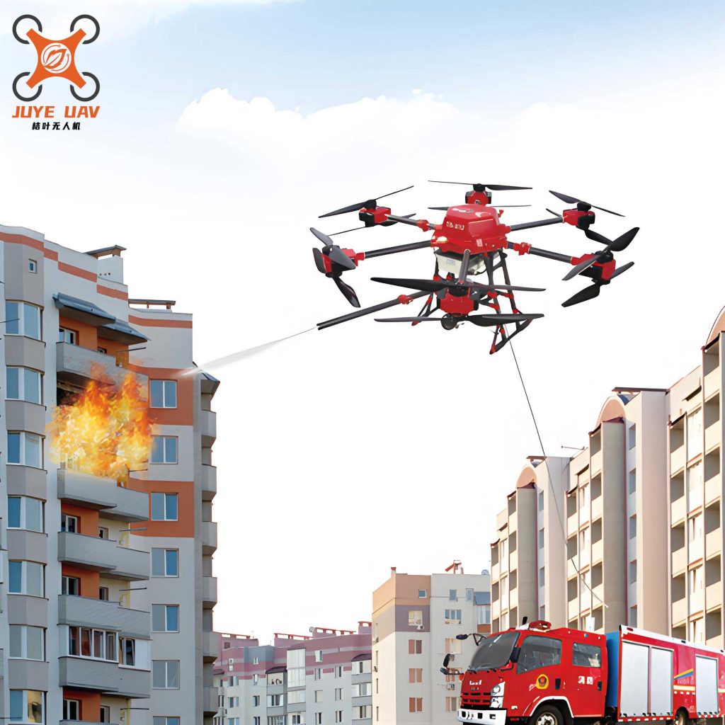
The Pivotal Role of the Fire Drone in Forest Protection
Among all applications, perhaps the most dramatic and socially critical is the use of the fire drone in wildfire management. Wildfires pose a catastrophic threat to forest resources, human life, property, and global carbon cycles. The integration of the fire drone has fundamentally altered the wildfire management cycle—prevention, detection, suppression, and damage assessment.
1. Prevention and Early Detection: The key to managing wildfires is discovering them when they are still small. UAVs equipped with thermal infrared cameras and real-time video downlinks can patrol high-risk areas beyond the line of sight of fire towers. A thermal sensor detects the heat signature of a nascent fire, often through smoke, at night, or in dense canopy. Automated smoke detection algorithms are also being developed to scan live video feeds. The moment an anomaly is detected, the exact GPS coordinates and visual/thermal imagery can be relayed to command centers within seconds, enabling a rapid initial attack.
2. Intelligence and Situational Awareness During Suppression: Once a fire is active, the fire drone becomes an indispensable eye in the sky. It can map the fire’s perimeter in real-time, track its rate of spread, and identify spot fires ahead of the main front. This live intelligence allows incident commanders to deploy ground crews and aerial tankers more effectively and safely. Thermal imaging can pinpoint hot spots under canopy or within smoldering ground fuels that are invisible to the naked eye, ensuring mop-up operations are thorough. The real-time data feed enhances operational safety by keeping personnel informed of changing fire behavior and escape route status.
3. Direct Suppression Support: Beyond reconnaissance, specialized heavy-lift fire drone platforms are being developed and deployed for direct suppression. These UAVs can carry payloads of water, fire retardant, or suppressant gels. While their payload capacity is currently less than manned helicopters, they offer unique advantages: they can operate in smoky conditions unsafe for pilots, access tight or treacherous terrain, and provide pinpoint accuracy in dropping suppressants on specific hot spots or to protect assets. Their use can be modeled as a resource allocation problem, optimizing the number of drops \( n \) per sortie given a payload mass \( m_p \) and a desired suppression effect per unit area \( E \):
$$ \text{Total Suppression Effect} = \sum_{i=1}^{n} (E_i \cdot A_i) $$
subject to constraints: \( \sum_{i=1}^{n} m_{p,i} \leq M_{UAV} \), and flight time \( T \leq T_{max} \).
4. Post-Fire Assessment: After a fire is contained, UAVs rapidly and safely conduct post-burn severity assessments. By comparing pre- and post-fire multispectral imagery, we can calculate indices like the Differenced Normalized Burn Ratio (dNBR) to map burn severity across the landscape:
$$ dNBR = NBR_{pre-fire} – NBR_{post-fire} $$
where $$ NBR = \frac{(NIR – SWIR)}{(NIR + SWIR)} $$
This high-resolution severity map is critical for planning erosion control, assessing natural regeneration potential, and designing reforestation projects.
| Fire Management Phase | Primary Role of Fire Drone | Key Sensor/ Payload | Outcome |
|---|---|---|---|
| Prevention & Detection | Automated patrol, hotspot identification | Thermal Camera, Visible Camera | Reduced initial attack time |
| Active Suppression | Real-time perimeter mapping, hotspot tracking | Thermal & RGB Video Downlink | Enhanced crew safety & tactical efficiency |
| Direct Attack | Precise delivery of water/retardant | Liquid payload dispenser | Pinpoint suppression, asset protection |
| Post-Fire Assessment | High-resolution burn severity mapping | Multispectral Sensor | Accurate damage assessment & rehab planning |
Persistent Challenges and Technical Hurdles
Despite the clear advantages, the operational integration of UAVs, including the essential fire drone, into mainstream forestry faces several non-trivial challenges.
1. Environmental and Operational Uncertainties: Forests are complex, dynamic, and often hostile environments for drones. Dense canopy can severely degrade or block GNSS (GPS) signals and radio communication links, leading to potential loss of control or data. Unpredictable wind patterns, especially in mountainous terrain or near fire fronts, challenge flight stability and battery endurance. Lighting conditions under canopy can be highly variable, affecting image quality for photogrammetry. For the fire drone, extreme heat plumes, thick smoke, and airborne embers present additional unique hazards to aircraft systems and sensors.
2. Data Processing and Analysis Bottlenecks: UAVs can generate terabytes of imagery in a single flight. The workflow from raw images to actionable information—involving data transfer, photogrammetric processing, point cloud generation, and analysis—can be computationally intensive and time-consuming. While automated algorithms for tree detection and classification are improving, they often require manual correction, especially in mixed-species or complex-structure forests. The integration of AI and machine learning for real-time analytics (e.g., instant fire detection, tree species ID) is promising but not yet universally robust or accessible.
3. Regulatory and Integration Barriers: Aviation regulations, especially concerning Beyond Visual Line of Sight (BVLOS) operations, are still evolving and can be restrictive. Flying a fire drone in active airspace shared with manned tankers and helicopters requires precise coordination and regulatory approval. Furthermore, there is a lack of standardized data formats, processing protocols, and certification frameworks tailored for forestry applications. This “wild west” landscape can hinder the development of interoperable systems and slow institutional adoption.
Future Trajectories and Concluding Perspective
The future of UAVs in forestry is inextricably linked to advancements in autonomy, artificial intelligence, and sensor fusion. I envision several key developments:
1. Increased Autonomy and Swarm Intelligence: Future systems will move beyond remote-piloted vehicles to fully autonomous agents. Swarms of coordinated drones could perform large-scale surveys simultaneously, with some mapping terrain, others assessing tree health, and yet others, acting as communication relays. In firefighting, a swarm of fire drone units could autonomously coordinate perimeter surveillance or perform synchronized retardant drops.
2. Edge Computing and Real-Time Analytics: To overcome data bottlenecks, processing will move from the desktop to the drone itself (“edge computing”). Onboard AI chips will allow a UAV to analyze imagery in real-time during flight—immediately identifying a new fire ignition, counting wildlife, or flagging areas of disease—and transmit only alerts and summaries instead of raw data.
3. Advanced Sensor Integration: The fusion of LiDAR, hyperspectral, and thermal data on a single platform will become more common and affordable. This will enable the derivation of incredibly detailed forest structural and physiological attributes in a single pass, providing a holistic view of ecosystem health and function.
4. Regulatory Evolution and Industry Standards: As the technology proves its value, regulatory frameworks will adapt to facilitate safe BVLOS operations, especially for critical applications like wildfire response. The industry will also coalesce around standards for data and operations, streamlining integration into existing forest management information systems.
In conclusion, from my perspective, the adoption of UAVs signifies a paradigm shift from traditional, often reactive forestry to a proactive, data-driven, and precision-based discipline. The fire drone stands out as a potent symbol of this shift—a tool that enhances human capability to protect one of our most vital resources. The challenges are significant but not insurmountable. By focusing on robust system design, intelligent automation, and collaborative policy development, we can fully unlock the potential of these aerial systems. The journey is towards an integrated, intelligent forest management framework where drones are not just tools, but essential partners in sustaining the health, productivity, and resilience of the world’s forests for generations to come.