
In modern industrial settings, steel manufacturing facilities represent some of the most challenging environments for emergency response, particularly in the event of a fire. The core production processes rely on extremely high-temperature heating, often exceeding 800°C, making fire incidents exceptionally dangerous and difficult to control. The complex infrastructure—a dense network of machinery, conduits, silos, and multi-level structures—creates a labyrinthine environment. When a fire erupts, it can rapidly escalate, generating intense heat, toxic smoke, and posing risks of structural collapse or secondary explosions from stored materials like metal powders, oils, and carbon. Traditional ground-based rescue operations are severely hampered; responders struggle to gain situational awareness, identify safe access routes, and locate trapped personnel in time. The deployment of a fire drone or an Unmanned Aerial Vehicle (UAV) specifically configured for firefighting and rescue missions offers a transformative solution to these critical limitations.
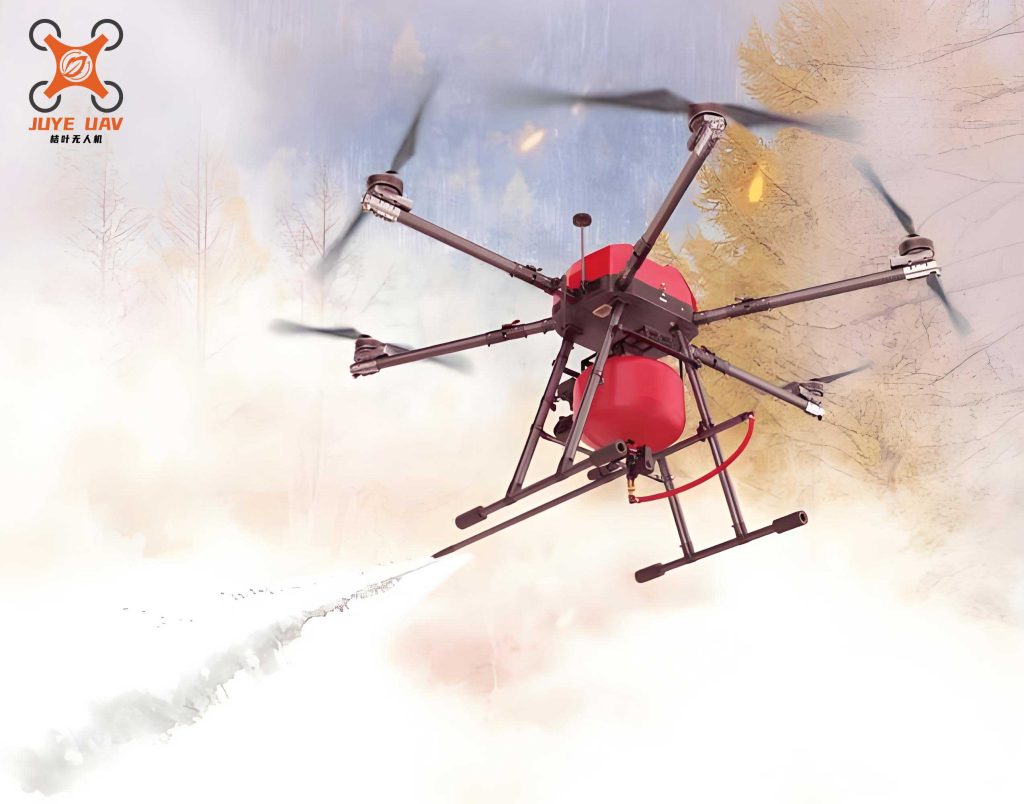
The inherent advantages of a fire drone—its compact size, high maneuverability, operational versatility, and ability to carry various payloads—make it uniquely suited for the steel plant context. Unlike manned aircraft or satellites, a fire drone can operate in confined spaces, navigate through narrow gaps between structures, and provide a stable aerial platform for close-range inspection without risking human pilots. It serves as an extension of the incident commander’s senses and capabilities, enabling data-driven decision-making from the moment of arrival. This paper explores the multifaceted applications of fire drone technology in steel plant fire emergencies, detailing their roles in initial reconnaissance, ongoing firefighting support, post-suppression search and rescue, and damage assessment, while also examining the specific operational workflows and technological integrations required for success.
1. Pre-Intervention Reconnaissance and Hazard Mapping
The initial minutes following a fire outbreak are crucial. A fire drone can be rapidly deployed to conduct an overhead survey, providing a comprehensive view of the incident that is impossible to obtain from ground level. This reconnaissance phase focuses on two primary objectives: mapping active fire fronts and identifying potential fuel sources or hazards.
1.1. Thermal Mapping and Fire Progression Analysis
Equipped with high-resolution visual (RGB) and thermal infrared (IR) cameras, a fire drone creates a real-time thermal map of the fireground. The thermal sensor detects radiated heat, allowing operators to visualize temperature differentials. This data is critical for identifying the core fire areas (hottest spots), tracking the direction of spread, and detecting hidden fires behind walls or under debris. The temperature data $T(x,y,t)$ captured by the drone at coordinates $(x,y)$ and time $t$ can be used to model fire spread dynamics. A simplified model for heat radiation-driven spread can be informed by data from the fire drone:
$$ \frac{\partial T}{\partial t} = \alpha \nabla^2 T + \frac{1}{\rho c} \dot{q}”’ – \frac{h}{\rho c d} (T – T_{\infty}) $$
where $\alpha$ is thermal diffusivity, $\rho$ is density, $c$ is specific heat, $\dot{q}”’$ is the volumetric heat generation rate from combustion, $h$ is the convective heat transfer coefficient, $d$ is a characteristic length, and $T_{\infty}$ is the ambient temperature. Data from the fire drone helps estimate parameters and validate such models in real-time.
1.2. Hazardous Material and Structural Integrity Identification
Steel plants contain unique hazards. A fire drone with multispectral or gas detection sensors can identify specific materials. For instance, it can locate storage areas for:
- Metal Powders: Fine aluminum or magnesium powders can cause devastating dust explosions.
- Quenching Oils and Hydraulic Fluids: These liquids can fuel rapid fire spread.
- Carbon and Coke: Solid fuels that sustain long-burning, intense fires.
- Pressurized Gas Lines and Electrical Conduits: Potential sources of explosion or electrocution.
Furthermore, by using visual imaging and perhaps LiDAR, the fire drone can assess structural integrity. It can detect signs of impending collapse—such as significant deflection, cracking, or distortion of support beams—alerting ground teams to avoid certain areas. The data collected forms the basis for creating a dynamic hazard map, which is continuously updated and shared with all responding units.
| Sensor Type | Function in Steel Plant Fire | Key Data Output |
|---|---|---|
| High-Resolution Visual Camera | General situational awareness, structural assessment, visual identification of hazards and victims. | RGB imagery, video stream. |
| Thermal Imaging Camera (Long-Wave IR) | Detection of heat sources through smoke, mapping fire perimeter and hotspots, locating trapped personnel via body heat. | Temperature matrix, false-color thermal video. |
| Multi-Gas Detector | Identification of toxic (CO, H2S) or explosive (CH4, H2) atmospheres. | Gas concentration levels (ppm/LEL). |
| LiDAR Scanner | 3D mapping of the environment, precise measurement of structural deformations, creation of digital twins for planning. | Point cloud data, 3D models. |
2. Active Firefighting Support and Intervention
Beyond reconnaissance, advanced fire drone platforms are engineered for direct intervention. These functional or “heavy-lift” drones are designed to carry and deploy fire suppressants or perform physical tasks to aid ground crews.
2.1. Aerial Fire Suppression and Exposure Protection
Functional fire drone systems can be fitted with tanks or dispensers for fire suppressants. Their primary role is not to extinguish a major steel plant fire single-handedly—their payload capacity is limited—but to perform critical tactical functions:
- Cooling and Exposure Protection: A fire drone can target adjacent structures or unignited fuel sources with water, foam, or inert gases (like CO2) to cool them and prevent fire spread. This creates a buffer zone, protecting critical assets and evacuation routes.
- Direct Attack on Small/Inaccessible Fires: They can access fires in elevated or confined spaces (e.g., on rooftops, inside ducts, between machinery) where hose streams cannot easily reach, applying suppressant precisely.
- Dust Explosion Mitigation: A fire drone can deploy a blanket of flame-retardant foam over open containers of metal powder to isolate them from ignition sources.
The release mechanism can be modeled as a controlled dispensation. For a liquid suppressant, the mass flow rate $\dot{m}_{disp}$ from the drone’s tank is a function of valve opening $A_v$, pressure $P$, and fluid density $\rho_f$:
$$ \dot{m}_{disp} = C_d A_v \sqrt{2 \rho_f P} $$
where $C_d$ is the discharge coefficient. The fire drone‘s flight control system must compensate for the changing mass and center of gravity during discharge.
2.2. Emergency Task Performance
Equipped with robotic manipulators, cutters, or winches, a functional fire drone can perform light rescue and utility tasks:
- Forcing Entry/Debris Clearance: Using a small pneumatic ram or cutter to clear a blocked window or door.
- Delivering Emergency Supplies: Dropping small fire blankets, respirators, or communication devices to trapped victims.
- Utility Control: Attempting to close a manual valve or disconnect a power line if it can be done safely via remote manipulation.
| Parameter | Reconnaissance/Search Drone | Functional/Heavy-Lift Fire Drone |
|---|---|---|
| Primary Mission | Data collection, mapping, search, hazard identification. | Direct intervention, payload delivery, physical task execution. |
| Typical Size & Weight | Small to Medium (e.g., 2-3m wingspan, <10kg) | Medium to Large (e.g., 2.5-4m, 25-100kg+ MTOW) |
| Key Payloads | Cameras (Visual/IR), Gas Sensors, LiDAR, Loudspeaker. | Liquid/foam tank & pump, robotic arm, cutter, winch, supply container. |
| Endurance | High (e.g., 60-120+ minutes). Focus on loiter time. | Moderate (e.g., 20-45 minutes). Impacted by heavy payload. |
| Deployment Speed | Very Fast. Often first on scene. | Slower. Requires specific setup and briefing. |
| Operational Ceiling | Higher (e.g., 4000m AGL for wide area survey). | Lower (e.g., <2000m AGL, typically operates at structure height). |
3. Post-Suppression Search, Rescue, and Damage Assessment
Once the main fire is under control, the environment remains perilous: unstable structures, hot surfaces, toxic atmospheres, and obscured spaces. The fire drone continues to be an invaluable asset during this “golden 24-hour” period for search and rescue.
3.1. Systematic Search in Hazard Zones
A fire drone can be tasked with systematically scanning areas too dangerous or inaccessible for human searchers. Using its thermal camera, it can detect the body heat signature of a survivor buried under cool debris. Combining visual and thermal data with AI-powered object recognition algorithms, the drone can flag potential victim locations. The search pattern can be optimized using algorithms. For a grid search over an area $A$, the total path length $L$ for a simple back-and-forth (lawnmower) pattern with sensor swath width $w$ is approximately:
$$ L \approx \frac{A}{w} + \text{perimeter terms} $$
More sophisticated algorithms like Bayesian search theory can be implemented, where the probability $P$ of a target being in cell $i$ is updated after each sensor pass by the fire drone:
$$ P_{new}(i) = \frac{P_{old}(i) \cdot (1 – PD)}{\sum_j [P_{old}(j) \cdot (1 – PD)]} \quad \text{if no detection} $$
where $PD$ is the probability of detection given the target is present, a parameter dependent on the fire drone‘s sensor quality and environmental conditions.
3.2. Asset Recovery and Preliminary Damage Assessment
Beyond human rescue, a fire drone can assist in recovering critical items such as sensitive electronic components, valuable prototypes, or important documents. A drone equipped with a gentle gripper can retrieve such items from precarious locations and transport them to a safe zone. Furthermore, the data collected by the fire drone—especially high-resolution imagery and LiDAR scans—is used to create detailed post-fire digital maps and 3D models. These models allow engineers to conduct a preliminary structural assessment, quantify material loss, and plan for safe demolition or repair operations without having to physically enter the unstable site.
4. Integrated Operational Workflow for Steel Plant Fire Incidents
The effective application of fire drone technology requires a standardized yet flexible operational workflow integrated into the overall Incident Command System (ICS).
4.1. Phase 1: Immediate Deployment and Rapid Assessment
- Launch: The first-arriving unit deploys a reconnaissance fire drone within minutes.
- Orbital Survey: The drone conducts a 360-degree orbit at a safe altitude, streaming live visual and thermal video to the Incident Commander (IC).
- Hazard Map Generation: Software processes the drone feed to generate an initial dynamic map showing fire location, intensity, and key hazards (fuel sources, power lines).
4.2. Phase 2: Detailed Scouting and Route Planning
- Close-Inspection: The fire drone navigates closer to key areas, using waypoint navigation: $W_i = (x_i, y_i, z_i, \psi_i)$, where $\psi$ is heading.
- Victim Search & Communication: If victims are suspected, the drone uses its thermal camera to search and its loudspeaker to establish contact.
- Rescue Path Analysis: Using its sensors, the drone identifies potential ingress/egress routes for ground teams, marking obstacles and heat zones. Path planning can involve cost functions $C(path)$ that penalize proximity to heat $T$, structural risk $R_s$, and distance $d$:
$$ C(path) = \int_{path} \left( \alpha \cdot T(s) + \beta \cdot R_s(s) + \gamma \cdot d(s) \right) ds $$
The fire drone‘s software solves for the path that minimizes $C(path)$.
4.3. Phase 3: Coordinated Intervention and Suppression
- Functional Drone Deployment: Based on the recon data, functional fire drone units are tasked with specific objectives (e.g., “cool the north wall of Silo B”).
- Swarm Operations (Future State): Multiple fire drone units, both reconnaissance and functional, can operate as a coordinated swarm. A central controller allocates tasks using algorithms from operations research, such as the Hungarian algorithm for optimal assignment of $N$ drones to $M$ tasks, minimizing total time or resource use.
- Real-Time Monitoring: Reconnaissance drones continue to monitor the effectiveness of suppression efforts, providing feedback on temperature reduction and fire containment.
4.4. Phase 4: Post-Fire Operations
- Systematic Search Grids: Drones are assigned predefined search grids over the debris field.
- Data Compilation for Assessment: All aerial data is compiled into a comprehensive digital report for fire investigation and insurance purposes.
| Incident Phase | Primary Fire Drone Tasks | Key Data/Output for Command |
|---|---|---|
| Phase 1: Rapid Assessment | Initial orbit, wide-area thermal scan, hazard spotting. | Live video feed, initial hotspot overlay on map, hazard markers. |
| Phase 2: Detailed Scouting | Close-proximity inspection, victim thermal search, route reconnaissance, atmospheric sampling. | High-res close-ups, identified victim locations, recommended safe routes, gas concentration maps. |
| Phase 3: Active Intervention | Aerial suppression (cooling/attack), emergency task performance (delivery, light breaching). | Suppressant deployment confirmation videos, before/after thermal comparison, task completion status. |
| Phase 4: Post-Fire | Systematic search for casualties, asset location/recovery, structural damage mapping. | Search completion maps, located assets/points of interest, detailed 3D model and damage report. |
5. Challenges and Future Technological Directions
Despite their promise, the deployment of a fire drone in steel plant fires faces significant challenges. The extreme heat can damage electronics and create powerful thermal updrafts that destabilize flight. Dense smoke obscures visual sensors, and complex metallic structures can interfere with GPS and radio communication links. Future developments are focused on overcoming these hurdles:
- Enhanced Durability: Developing better thermal shielding and cooling systems for the fire drone to operate closer to intense fires for longer durations.
- Sensor Fusion and AI: Integrating data from visual, thermal, LiDAR, and radar sensors to create a coherent picture even in smoke. AI algorithms will automatically identify hazards, victims, and structural defects.
- Resilient Communication: Implementing mesh networking between drones and ground units to ensure robust data links even when direct line-of-sight to the controller is lost.
- Autonomous Operation: Moving beyond remote-piloted to fully autonomous fire drone swarms that can execute complex missions like interior mapping and suppression with minimal human oversight, guided by onboard AI that processes sensor data in real-time.
6. Conclusion
The integration of fire drone technology into the emergency response protocol for steel manufacturing facilities represents a significant leap forward in industrial safety. The fire drone acts as a force multiplier, providing unprecedented situational awareness from the air, enabling precise tactical interventions, and performing dangerous search tasks without exposing personnel to unnecessary risk. From the initial chaotic moments of a fire through to the meticulous post-incident assessment, the fire drone delivers critical data and capabilities. As the technology matures—with improvements in autonomy, sensor fusion, durability, and swarm intelligence—the role of the fire drone will evolve from a supportive tool to a central pillar of intelligent firefighting systems. For the inherently hazardous environment of a steel plant, the adoption and continuous development of specialized fire drone solutions are not merely advantageous but essential for enhancing operational effectiveness, protecting lives, and securing valuable industrial assets.