
As a practitioner deeply embedded in the field of emergency response, I have witnessed a paradigm shift in operational capabilities with the advent of unmanned aerial systems. The integration of multi-rotor Unmanned Aerial Vehicles, specifically designed for and deployed in fire and rescue scenarios—what I will refer to throughout as fire UAVs—marks a significant evolution. This article synthesizes frontline experience with technical analysis to explore the current applications, inherent challenges, and future developmental pathways for these systems. The objective is to articulate a coherent framework for their deployment, moving beyond anecdotal use to systematic, doctrine-driven integration that enhances responder safety and mission efficacy in the face of “all-disaster” and “major-emergency” demands.
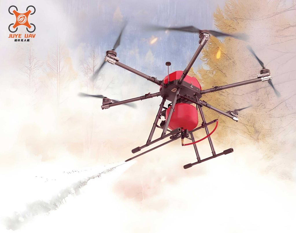
The core value proposition of a fire UAV lies in its ability to serve as a force multiplier, providing an aerial platform for reconnaissance, communication, and direct intervention where human access is limited, dangerous, or inefficient. The transition of the fire UAV from a novel gadget to a standard-issue piece of rescue equipment is not merely a trend but a necessary direction for the modernization of firefighting and technical rescue assets.
I. Deployment of Fire UAVs in Fire Suppression Operations
In fireground operations, situational awareness is paramount. The fire UAV fundamentally alters the reconnaissance paradigm, offering a dynamic, overhead perspective that was previously unattainable without significant risk or resource allocation (e.g., ladder platforms, aerial apparatus).
A. Situational Awareness and Reconnaissance
The primary and most immediate application is in scene size-up and ongoing monitoring. In complex structures such as large-span warehouses, high-rise buildings, and subterranean facilities, initial interior reconnaissance by personnel is fraught with peril due to unpredictable collapse, rapid fire spread, and toxic atmospheres. A fire UAV, equipped with high-definition visual and thermal imaging cameras, can be rapidly deployed to conduct an exterior and limited interior assessment. The real-time video feed provides command staff with critical data on fire location, intensity, spread vectors, and structural integrity. For hazardous materials incidents, a fire UAV can safely approach to identify placards or container conditions, vastly improving initial decision-making. The operational advantage can be summarized by the enhanced information gain per unit risk:
$$ \text{Operational Efficiency} (OE) = \frac{\text{Information Gained}}{\text{Risk to Personnel}} $$
Where a traditional recon team faces high risk for moderate information, a fire UAV yields high information for negligible personnel risk, thus maximizing OE.
| Fire Scenario | Fire UAV Capability | Data Output for Command |
|---|---|---|
| High-Rise Fire | Exterior facade inspection, window-level thermal scanning | Floor of origin, fire spread between floors via curtain wall, presence of occupants at windows. |
| Large-Span Structure (e.g., Warehouse) | Overhead thermal mapping of roof, identification of hotspots | Location of seat of fire under roof, potential for roof collapse, fire spread pattern across storage arrays. |
| Hazardous Materials Incident | Safe-distance visual and gas detection (with specialized sensor module) | Container identification, visible leaks, qualitative gas concentration readings in plume. |
| Wildland-Urban Interface | Broad-area aerial mapping, fire front tracking | Rate of spread, direction, identification of spot fires ahead of main front, assessment of structural exposure. |
B. Search, Rescue, and Evacuation Support
Beyond fire mapping, the fire UAV plays a crucial role in search and evacuation management. Equipped with a loudspeaker module, it can broadcast clear instructions to evacuees who may be disoriented by smoke or panic, guiding them to safe routes or instructing them to shelter in place. This application is particularly vital in complexes without public address systems. Furthermore, using thermal imaging, a fire UAV can perform rapid searches for victims in smoke-filled rooms or obscured areas, such behind structures in wildland fires, pinpointing locations for rescue teams and potentially reducing search time exponentially. The probability of detection (Pd) with a thermal imager in obscured conditions is significantly higher than with human vision alone.
C. Active Fire Intervention and Mitigation
The role of the fire UAV is expanding from passive observation to active intervention. Two key modalities are emerging:
- Ventilation Support: Smoke, more than flame, is the leading cause of fire fatalities. When natural or mechanical ventilation fails, firefighters must create vertical or horizontal vents. A fire UAV equipped with a small, remotely operated cutting or breaking tool can approach upper-story windows or skylights to clear openings for smoke ejection, a task that would otherwise require setting up ladders or elevating platforms under hazardous conditions.
- Direct Agent Application: For incipient fires or to protect exposures, fire UAVs can carry and discharge suppressants. High-lift-capacity platforms can deliver small firebreak-creating retardant gels in wildland settings or deploy compact extinguishing agent payloads (e.g., dry chemical, compressed aerosol) through targeted windows in structural fires. The payload mass (mp) is a critical limitation, related to the thrust (T) required for stable hover:
$$ T > (m_{UAV} + m_{p}) \cdot g $$
where \( m_{UAV} \) is the mass of the fire UAV itself, and \( g \) is gravitational acceleration. Advances in battery energy density and airframe design are steadily increasing the viable \( m_{p} \).
D. Post-Fire Overhaul and Investigation
After fire control, the fire UAV remains a valuable tool. Equipped with a high-resolution thermal camera, it can systematically scan an overhaul area—especially in large, complex, or structurally compromised buildings—to identify hidden hotspots that could cause rekindle. This method is faster, safer, and more thorough than manual probing by crews. The data can be geo-tagged to create a thermal map of the site, providing documentation for investigators and ensuring fire complete extinguishment.
II. Deployment of Fire UAVs in Technical Rescue Operations
The agility and payload flexibility of the multi-rotor fire UAV make it equally transformative in diverse technical rescue disciplines beyond fire.
| Rescue Discipline | Traditional Method Limitation | Fire UAV Solution | Key Performance Metric |
|---|---|---|---|
| Swiftwater/Flood Rescue | Throw bag accuracy limited to ~30m; line deployment hazardous for rescuers. | Precise aerial delivery of life rings or inflatable devices up to 1km; initial lightweight rope line deployment across channels. | Payload Accuracy (% of deliveries within 3m of target), Max Deployable Payload Mass. |
| Hornet/Wasp Nest Removal | High-risk climbing or proximity work in protective gear; flame application risky near combustibles. | Stand-off removal via mounted flamethrower or precision injection of pesticide. | Stand-off Distance (m), Total Elimination Time per Nest (min). |
| Earthquake/Collapse Search | Slow, dangerous surface recon; difficult to assess overall damage pattern. | Rapid aerial mapping for damage assessment, victim location via thermal imaging, communication relay, light payload delivery to voids. | Area Coverage Rate (km²/hr), Real-time Data Latency (s). |
| Hazardous Atmosphere Assessment | Requires donning Level A/B suits; slow entry and monitoring. | Rapid deployment of chemical, biological, radiological, nuclear (CBRN) sensors into plume or confined space. | Sensor Sensitivity, Data Transmission Integrity in RF-challenged environments. |
A. Water Rescue
In swiftwater or flood rescue, time and precision are critical. A fire UAV can fly directly to a victim, hover, and lower or release a personal flotation device with far greater accuracy than a shore-based throw. For more complex scenarios, it can ferry the end of a light tension line across a river to establish the initial connection for a highline system, eliminating the need for dangerous swims or boat deployments in the initial phase.
B> Nuisance Animal and Hive Removal
The removal of stinging insect nests from high or precarious locations is a common, yet risky, call. A specialized fire UAV, operated by a trained team, can apply a focused flame or inject pesticide directly into the nest entrance from a safe distance, typically completing the task in 15-20 minutes while keeping personnel entirely out of harm’s way. The safety enhancement is quantifiable:
$$ \text{Risk Reduction Factor} = 1 – \frac{\text{Probability of Sting with UAV}}{\text{Probability of Sting with Traditional Method}} $$
This factor approaches 1 (complete risk elimination) for nests in extremely hazardous locations (e.g., high-voltage towers, tall trees).
C. Disaster Assessment and Light Logistics
Following earthquakes, landslides, or major storms, ground access is often severed. A fire UAV can be one of the first assets on scene, providing rapid aerial imagery to create 2D orthomosaics and 3D models of the affected area. This data is indispensable for identifying blocked roads, damaged infrastructure, landslide volume, and potential survivor locations. Furthermore, a fire UAV can act as a temporary communication repeater to extend radio coverage for ground teams or deliver small, critical supplies like medicines, water, or two-way radios to isolated survivors. The future points towards a “fire UAV-plus-robot” paradigm, where the aerial vehicle acts as a mothership, transporting and deploying small ground robots into rubble piles for deeper inspection.
III. Technical Challenges and Developmental Imperatives for Next-Generation Fire UAVs
The extreme environments inherent to emergency response impose stringent requirements that exceed those for commercial or recreational drones. The next generation of fire UAV platforms must evolve to meet these challenges.
A. Environmental Hardening
Operational robustness in harsh conditions is non-negotiable. Two key areas are:
- Thermal and Particulate Resistance: To operate in proximity to fire, a fire UAV requires thermal protection for its electronic and mechanical components. This involves heat-resistant composites, active cooling systems, and protective shrouds. Additionally, intake filters are needed to prevent smoke particulates from damaging motors and bearings. The system must maintain functionality in ambient temperatures exceeding \( 100^\circ\text{C} \) for short durations.
- All-Weather Capability: Rescue does not pause for rain. Enhancing ingress protection (IP) ratings to withstand heavy rain and wind gusts is essential. The aerodynamic stability in wind can be modeled by considering the drag force \( F_d \):
$$ F_d = \frac{1}{2} \rho v^2 C_d A $$
where \( \rho \) is air density, \( v \) is wind velocity, \( C_d \) is the drag coefficient, and \( A \) is the cross-sectional area. Designs with lower \( C_dA \) and flight control systems that can compensate for higher \( F_d \) are needed.
B. Electromagnetic Interference (EMI) Resilience
Urban canyons, industrial sites, and disaster zones are often saturated with electromagnetic noise that can disrupt GPS signals and control links, leading to fly-away or loss of control. A resilient fire UAV must employ a multi-modal navigation and communication suite:
- Multi-Constellation GNSS: Fusing data from GPS, GLONASS, Galileo, and BeiDou.
- Redundant Control Links: Utilizing frequency hopping and mesh networking protocols.
- Inertial Navigation Systems (INS) Aiding: Using high-quality IMUs to bridge short-term GNSS outages. The position error \( \epsilon_{pos} \) of an INS grows with time \( t \):
$$ \epsilon_{pos}(t) \approx \epsilon_{vel} \cdot t + \frac{1}{2} \epsilon_{accel} \cdot t^2 $$
where \( \epsilon_{vel} \) and \( \epsilon_{accel} \) are velocity and accelerometer biases. Therefore, minimizing sensor bias and frequently correcting with GNSS or visual odometry is critical.
C. Endurance and Power Systems
The Achilles’ heel of electric multi-rotors remains flight time. Most current platforms offer 20-45 minutes of operational hover, insufficient for prolonged missions like wide-area search or fire monitoring. The fundamental limitation is the specific energy of batteries. The theoretical maximum flight time \( t_{max} \) for a battery-electric UAV can be approximated by:
$$ t_{max} = \frac{E_{batt} \cdot \eta}{P_{hover}} $$
where \( E_{batt} \) is the battery energy, \( \eta \) is the total powertrain efficiency, and \( P_{hover} \) is the power required to hover. Development is focused on:
- Higher specific energy batteries (e.g., lithium-sulfur).
- Hybrid-electric systems using a fuel-powered generator to extend endurance to 2+ hours.
- Automated docking stations for battery swapping or recharging in the field.
IV. Strategic Implementation Pathway for Fire UAVs in Fire and Rescue Services
To realize the full potential of this technology, a strategic, phased approach to acquisition, training, and doctrine development is required.
A. Tiered and Mission-Specific Procurement
A one-size-fits-all approach is inefficient. Agencies should adopt a tiered model aligning platform capability with organizational level and primary risk profile.
| Agency Level/Unit Type | Recommended Fire UAV Type | Primary Missions | Key Module Requirements |
|---|---|---|---|
| Local Fire Station (Company) | Small, portable, rapid-deployment quadcopter | Initial scene size-up, structure fire recon, small-area search, pre-fire planning. | HD/Visual Camera, Basic Thermal Imager, Loudspeaker. |
| Specialized Rescue/Hazmat Team | Medium-lift, ruggedized hexacopter/octocopter | Technical rescue (water, collapse), Hazmat sensing, light payload delivery (life vests, sensors). | Advanced Thermal (high res), GNSS/INS, Payload Release, Gas Detector, Flir/Spotlight. |
| Regional/Command Level | Heavy-lift, long-endurance platform (hybrid) | Large-area disaster assessment (wildfire, flood), Extended operations, Communication relay, Larger payload transport. | Survey-grade photogrammetry camera, Multi-spectral sensors, Relay module, 5+ kg payload capacity. |
B. Development of a Professional Operator Corps
The technology is only as good as its operator. Investing in comprehensive training programs is essential. This goes beyond basic flight skills to include:
- Mission-Specific Tactics: Flying in tight spaces, managing sensor payloads, operating in RF-noisy environments.
- Maintenance and Logistics: Ensuring airworthiness, managing batteries, and troubleshooting field issues.
- Data Interpretation: Training to analyze thermal images, map data, and sensor readings to provide actionable intelligence to incident command.
- Regulatory and Airspace Integration: Deep understanding of FAA/ICAO regulations, obtaining necessary certifications (e.g., Part 107 in the U.S.), and coordinating with air traffic control for major incidents.
A standardized certification track for Public Safety UAS Operators should be established and recognized across the profession.
C. Fostering Tactical Innovation and Interoperability
As the fleet of fire UAVs grows, so must the collective knowledge of how to use them effectively. This requires:
- Establishing formal tactics, techniques, and procedures (TTPs) that are integrated into standard operating guidelines.
- Creating platforms for sharing after-action reviews and lessons learned from real-world deployments across different agencies.
- Ensuring data interoperability, so video feeds and mapping products from a fire UAV can be seamlessly shared with command software and other agencies (law enforcement, EMS) on scene.
The evolution of the fire UAV is a continuous process, driven by technological advancement and refined by operational experience.
In conclusion, the integration of multi-rotor fire UAVs into the fire and rescue service represents a fundamental enhancement of operational capability. From providing god’s-eye-view situational awareness to executing precision rescue tasks and direct hazard mitigation, the applications are vast and growing. However, to move from potential to proven, sustained investment in hardened technology, specialized training, and doctrinal development is imperative. By embracing a structured, tiered approach to implementation and fostering a culture of innovation, fire and rescue agencies can ensure that the fire UAV fulfills its promise as a transformative, life-saving, and property-conserving asset, solidifying its place as an indispensable tool in the modern responder’s toolkit. The future of rescue is not just on the ground; it is increasingly in the coordinated, intelligent airspace above the incident.