
The landscape of public safety and law enforcement is undergoing a profound transformation, driven by rapid technological advancement. Among the most significant developments is the integration of Unmanned Aerial Vehicles (UAVs) into police and emergency service protocols. From my perspective as an analyst observing this evolution, the adoption of police drone technology represents a strategic pivot towards enhancing operational capabilities, mitigating risks to human life, and achieving superior situational awareness. The core advantages of police drone systems—exceptional flexibility, relatively low operational cost, high stability in various environments, and the fundamental reduction of risk to personnel—have cemented their role as a cornerstone of modern “smart policing” initiatives. This essay explores the multifaceted applications of police drone technology in emergency response, underpinned by analytical models, comparative data, and a discussion of the prevailing challenges that must be addressed to fully realize their potential.
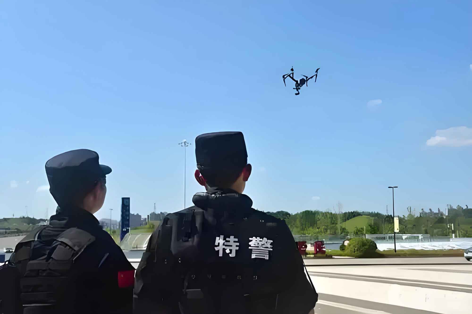
The term “police drone” refers specifically to UAVs deployed by law enforcement and associated emergency services for missions including surveillance, reconnaissance, communication relay, and tactical intervention. These systems are typically equipped with advanced payloads such as high-resolution electro-optical (EO) cameras, thermal imaging sensors, loudspeakers, and, in specialized cases, non-lethal payload deployment mechanisms. The operational efficacy of a police drone can be initially modeled by its core performance parameters, which dictate its suitability for different scenarios. Key parameters include endurance \( T \), operational range \( R \), maximum payload capacity \( P_{max} \), and effective sensor resolution \( \rho \). A simplified utility function \( U \) for a police drone on a surveillance mission can be conceptualized as:
$$ U = k \cdot \frac{T \cdot \rho \cdot A_{cov}}{P_{power}} $$
where \( A_{cov} \) represents the area coverage rate, \( P_{power} \) is the power consumption, and \( k \) is a mission-specific constant. This illustrates the trade-offs between flight time, sensor quality, and energy efficiency that planners must consider.
Classification and Technical Foundations of Police Drones
Not all UAVs are created equal, and the choice of platform is critical to mission success. The primary categories of police drone platforms are fixed-wing, rotary-wing (single main rotor or helicopter-style), and multi-rotor (most commonly quadcopters and hexacopters). Each type possesses distinct aerodynamic and operational characteristics, making them suitable for different phases of emergency response.
| Platform Type | Key Advantages | Primary Limitations | Ideal Emergency Response Use Case |
|---|---|---|---|
| Fixed-Wing | Long endurance (T), High speed, Large operational range (R) | Requires runway/launch area, Cannot hover, Complex operation | Large-area search (e.g., missing persons in wilderness), Perimeter patrol of major incidents, Long-duration traffic monitoring on highways. |
| Single Rotor Helicopter | High payload capacity (P_max), Long endurance for rotary-wing, Can handle stronger winds | High cost, Mechanical complexity, Significant safety concerns, Requires skilled pilot | Heavy-lift missions (e.g., delivering substantial rescue supplies), Persistent stationary observation in challenging weather. |
| Multi-Rotor (Quad/Hexa) | Vertical Take-Off and Landing (VTOL), Precise hovering, High maneuverability, Ease of operation, Lower cost | Short flight time (low T), Limited speed and range (R), Vulnerable to strong winds | Crowd monitoring, Tactical building reconnaissance, Close-range accident scene documentation, Indoor search in complex structures. |
The exponential growth in the police drone market has been predominantly in the multi-rotor sector due to its accessibility and versatility for tactical, close-range operations. The technical foundation of a modern police drone system extends beyond the airframe to encompass the data link for real-time communication, the Ground Control Station (GCS) for piloting and data analysis, and sophisticated software for mission planning, automated flight, and data processing (e.g., photogrammetry for 3D maps). The strength and security of the data link, often defined by its latency \( L \) and bandwidth \( B \), are crucial for real-time command and control. The effective information throughput \( I_{eff} \) for a police drone transmitting video can be expressed as:
$$ I_{eff} = B \cdot \log_2\left(1 + \frac{S}{N}\right) – \alpha L $$
where \( S/N \) is the signal-to-noise ratio and \( \alpha \) is a latency-sensitivity factor. A secure, low-latency, high-bandwidth link is essential for dynamic operations.
Analytical Framework for Police Drone Deployment in Critical Incidents
The deployment of a police drone is not merely a tactical decision but a strategic one that can be optimized. We can analyze different emergency scenarios through the lens of required capabilities, which in turn dictates the choice of platform and payload.
| Emergency Scenario | Primary Mission Objectives | Key Required Capabilities | Recommended Sensor Payloads | Typical Platform Choice |
|---|---|---|---|---|
| Counter-Terrorism / Armed Standoff | Real-time ISR (Intelligence, Surveillance, Reconnaissance), Suspect tracking, Tactical delivery, Operational planning. | Stealth/Quiet operation, High-resolution EO/IR imaging, Real-time low-latency video, Possible non-lethal payload capacity. | 4K EO Zoom, Thermal Camera, Loudspeaker, Payload release mechanism. | Multi-rotor (small, quiet), Specialized tactical UAV. |
| Major Traffic Collision / Highway Incident | Rapid scene assessment, Traffic flow analysis, Evidence documentation, Assisting clearance. | Rapid deployment, Wide-area coverage, High-altitude stable hover, Photogrammetry capability. | Wide-angle camera, High-resolution still camera for orthomosaics. | Multi-rotor (for detail), Fixed-wing (for overall traffic flow over miles). |
| Crowd Management & Public Disorder | Mass movement monitoring, Identifying instigators, Communication broadcast, Evidence gathering for prosecution. | Long endurance for persistent watch, Crowd analytics software, Loudspeaker/public address system. | Pan-Tilt-Zoom (PTZ) camera, Thermal for night ops, Loudspeaker. | Long-endurance multi-rotor or hybrid VTOL fixed-wing. |
| Urban Fire & Search and Rescue (SAR) | Locating hotspots, Identifying victims, Assessing structural integrity, Delivering initial aid. | Ability to fly in smoky/obscured conditions, Thermal imaging for heat signatures, Payload delivery for small items. | Radiometric thermal camera, Gas sensor, Payload hook. | Robust multi-rotor (hexacopter/octocopter for redundancy). |
| Natural Disaster Assessment | Damage mapping, Locating survivors in rubble, Routing for ground teams, Infrastructure inspection. | Long range and endurance, Ability to operate in degraded GPS environments, Robust data link. | Mapping camera, LiDAR, Thermal camera, Multispectral sensors. | Fixed-wing for large area, Heavy-lift multi-rotor for targeted SAR. |
The operational effectiveness \( E_{op} \) of a police drone in a given scenario can be conceptualized as a weighted sum of its capability match:
$$ E_{op} = \sum_{i=1}^{n} w_i \cdot C_i $$
where \( C_i \) represents the drone’s performance score for the i-th required capability (e.g., resolution, endurance, payload), and \( w_i \) is the predetermined weight of that capability for the specific mission. This model helps in pre-mission platform selection and procurement planning.
Deep Dive: Quantitative Impact in Key Application Areas
1. Counter-Terrorism and Hostile Engagement
In a high-risk scenario like an armed standoff or terrorist incident, the police drone serves as a force multiplier and a risk mitigator. Its primary value is in providing “over-the-hill” reconnaissance without exposing officers. A drone equipped with thermal imaging can detect human signatures through visual obstacles like smoke or light foliage, governed by the principle of Planck’s Law for blackbody radiation. The radiative power \( P_{\lambda} \) detected by the drone’s sensor at wavelength \( \lambda \) from a body at temperature \( T \) is approximated by:
$$ P_{\lambda} \approx \frac{2\pi h c^2}{\lambda^5} \cdot \frac{1}{e^{\frac{hc}{\lambda k_B T}} – 1} $$
where \( h \) is Planck’s constant, \( c \) is the speed of light, and \( k_B \) is Boltzmann’s constant. The contrast between a human body (~310K) and a typical background (~300K) is what the thermal sensor captures. Furthermore, the tactical advantage \( A_{tact} \) gained by deploying a police drone for initial reconnaissance can be modeled as an increase in the probability of mission success \( P_{success} \) and a decrease in the probability of friendly casualty \( P_{casualty} \):
$$ A_{tact} = \Delta P_{success} – \beta \cdot \Delta P_{casualty} $$
where \( \beta \) is a high weighting factor reflecting the paramount importance of officer safety. The ability to precisely deliver non-lethal agents (e.g., flash-bang, tear gas) from an aerial platform also creates new tactical options, with the delivery accuracy being a function of hover stability, wind conditions, and release mechanism precision.
2. Traffic Incident Management and Forensic Reconstruction
Following a major traffic accident, rapid scene understanding is critical. A police drone can be airborne in minutes, providing an orthogonal, comprehensive view that ground officers cannot achieve. By conducting an automated nadir (straight-down) imaging grid flight, the drone collects hundreds of overlapping images. Using photogrammetric principles, these images are processed to generate accurate 2D orthomosaics and 3D models of the scene. The scale and accuracy of the 3D model depend on the Ground Sample Distance (GSD), which is the distance between pixel centers measured on the ground. It is calculated as:
$$ GSD = \frac{H \cdot s}{f} $$
where \( H \) is the flight altitude above ground, \( s \) is the sensor pixel size, and \( f \) is the lens focal length. A lower GSD (achieved by flying lower, using a better sensor, or a longer lens) yields higher model accuracy, crucial for measuring skid marks, vehicle deformation, and final positions. This digital twin of the scene becomes an immutable, measurable record for forensic analysis and courtroom presentation, far surpassing traditional hand-drawn diagrams. The efficiency gain \( G_{eff} \) in scene processing time using a police drone versus traditional methods can be significant:
$$ G_{eff} = \frac{T_{traditional}}{T_{drone}} $$
where values for \( G_{eff} \) often range from 3 to 10, meaning the drone-based method is 3 to 10 times faster.
3. Crowd Dynamics Monitoring and Public Order
During large protests or public gatherings, a police drone offers a persistent, wide-area surveillance platform. Advanced video analytics software can process the live feed to estimate crowd density \( \rho_{crowd} \) (persons per square meter), detect anomalous motion vectors, and track the movement of specific individuals (if initially identified). The crowd density can be estimated using machine learning algorithms trained on aerial imagery, providing real-time data to commanders about potential choke points or overcrowding. The primary operational benefit is enhanced command, control, and awareness (C2A). The informational advantage \( I_{adv} \) provided to the command center can be expressed as the ratio of the monitored area \( A_{mon} \) by the drone to the area visible from ground units \( A_{ground} \), adjusted for the quality of information \( Q \):
$$ I_{adv} = Q \cdot \frac{A_{mon}}{A_{ground}} $$
Typically, \( I_{adv} >> 1 \), granting commanders a decisive overview. Furthermore, the drone-mounted loudspeaker serves as a direct communication channel for broadcasting instructions or warnings, adding a powerful tool for de-escalation and public information dissemination.
Technical and Operational Challenges: A Constraint Analysis
Despite their proven utility, the widespread integration of police drone systems faces significant hurdles. These constraints must be factored into any strategic deployment model.
| Challenge Category | Specific Issues | Potential Impact on Operations | Possible Mitigation Strategies |
|---|---|---|---|
| Technical Limitations | Short Battery Life (T), Limited Payload (P_max), Vulnerability to Jamming/ Cyber-attack, Sensitivity to Adverse Weather (wind, rain). | Reduced on-station time, Inability to carry necessary equipment, Loss of control or data link, Grounded operations in poor conditions. | Investment in hybrid power systems, Development of standardized payload interfaces, Implementation of encrypted, frequency-hopping data links, Establishment of strict weather minimums. |
| Regulatory & Legal Framework | Restrictive Airspace Regulations, Privacy Concerns and Public Perception, Lack of Clear Protocols for Evidence Admissibility, Liability in Case of Failure or Accident. | Delayed launch awaiting clearance, Public backlash and mistrust, Court challenges to drone-gathered evidence, Financial and reputational risk. | Proactive engagement with aviation authorities for priority access, Transparent public policies on data use, Development of standardized evidence collection SOPs, Comprehensive insurance and safety training. |
| Human Resource & Logistics | Shortage of Trained Pilots and Analysts, High Initial Acquisition and Maintenance Costs, Lack of Standardized Training Curricula, Storage and Maintenance Infrastructure. | Underutilization of purchased assets, High total cost of ownership, Inconsistent operational proficiency, Downtime due to poor maintenance. | Establishment of dedicated UAV units with career paths, Lifecycle cost analysis for procurement, Creation of national/international training standards, Investment in dedicated support facilities. |
The overall readiness score \( R_{unit} \) of a police drone unit can be modeled as a product of these constrained factors:
$$ R_{unit} = T_{tech} \cdot C_{reg} \cdot S_{hr} \cdot L_{log} $$
where each term \( T_{tech}, C_{reg}, S_{hr}, L_{log} \) is a normalized score (between 0 and 1) for technical reliability, regulatory freedom, staff proficiency, and logistical support, respectively. A deficiency in any one area can drastically reduce overall readiness.
Conclusion and Future Trajectory
In conclusion, the police drone has evolved from a novel gadget into an indispensable component of the modern public safety toolkit. Its ability to provide rapid, bird’s-eye-view intelligence, perform tasks in hazardous environments, and do so with minimal risk to personnel offers a compelling value proposition. The analytical frameworks presented—using concepts from performance metrics \( (T, R, P_{max}) \), utility functions \( (U) \), and operational effectiveness scores \( (E_{op}) \)—provide a structured way to evaluate and deploy these assets. As technology progresses, we can anticipate the integration of artificial intelligence for automated threat detection, the development of longer-endurance and more robust platforms, and the creation of swarming capabilities where multiple police drone units operate collaboratively under a single controller. However, the path forward is not solely technological. It is imperative to develop robust legal frameworks, foster public trust through transparent policies, and invest in the human capital required to operate and maintain these complex systems. The future of emergency response will undoubtedly be more integrated, data-driven, and aerial, with the police drone serving as a critical node in a networked system of safety, security, and service.