The integration of Unmanned Aerial Vehicles (UAVs) into modern forestry represents a paradigm shift, moving from labor-intensive, traditional methods towards a data-driven, intelligent, and precise management framework. The evolution from early military applications to versatile civilian tools has unlocked unprecedented potential for monitoring, protecting, and sustainably utilizing forest resources. Among the diverse UAV platforms, specialized fire UAV systems have emerged as particularly transformative, offering critical capabilities in prevention, detection, and response to one of forestry’s most devastating threats. This review explores the multifaceted applications of UAV technology across the forestry sector, with a particular emphasis on the role of fire UAV systems, while also addressing the persistent challenges and future trajectories for this synergistic integration.
The limitations of conventional forestry practices are pronounced. Manual surveys are time-consuming, costly, and often hazardous in rugged or remote terrain. Satellite imagery, while broad in coverage, can suffer from low spatial resolution, cloud occlusion, and infrequent revisit times. Manned aircraft operations involve high costs and significant safety risks for pilots, especially in low-altitude, complex flight environments. UAVs, conversely, offer a compelling solution set: high spatial and temporal resolution, operational flexibility under various weather conditions, significant cost-effectiveness for repetitive missions, and the removal of personnel from direct danger. This technological pivot is not merely additive but foundational to the concept of “Smart Forestry,” where real-time data and automated interventions become central to stewardship.
Core Applications of UAVs in Forestry Operations
The utility of UAVs spans the entire forestry value chain, from inventory and production to protection and conservation. Their deployment is catalyzing efficiency and accuracy across several key domains.
1. Precision Forest Inventory and Timber Production
Accurate forest inventory is the cornerstone of sustainable management. UAVs equipped with high-resolution RGB, multispectral, or LiDAR sensors can generate detailed 3D point clouds and orthomosaics of forest stands. From these data products, key dendrometric parameters can be extracted with high precision.
- Individual Tree Detection (ITD) and Crown Delineation: Algorithms applied to UAV imagery can automatically identify individual trees and map their crown areas, enabling tree-level inventories over large areas. The crown area $A_c$ is often related to stem diameter or biomass.
- Height and Volume Estimation: Using photogrammetric or LiDAR-derived digital surface models (DSM) and digital terrain models (DTM), tree height $H$ is calculated as: $$H = DSM – DTM$$ Combined with species-specific allometric equations, timber volume $V$ can be estimated, for example, using a standard form factor $f$ and breast height diameter $DBH$: $$V = f \cdot \pi \cdot \left(\frac{DBH}{2}\right)^2 \cdot H$$
- Harvest Planning and Operations: UAV maps guide optimal harvest planning, road layout, and machinery access. In innovative logging concepts, UAVs are being explored for drone-based skyline yarding systems, potentially reducing ground disturbance and improving worker safety in steep terrain.
| Sensor Type | Primary Data | Key Forestry Metrics | Advantages |
|---|---|---|---|
| High-Resolution RGB | Visible-spectrum imagery | Tree counting, crown mapping, health assessment (visual) | Low cost, high detail, easy interpretation |
| Multispectral | Reflectance in specific bands (e.g., Red Edge, NIR) | Vegetation indices (NDVI), species discrimination, stress detection | Quantitative plant health analysis |
| LiDAR | 3D point cloud | Canopy height, structure, biomass, terrain model | Penetrates canopy, highly accurate 3D structure |
| Hyperspectral | Continuous reflectance spectrum | Detailed species ID, biochemical property estimation | Extremely rich spectral data for advanced analysis |
2. Forest Health Monitoring and Disease Control
Early detection of pest infestations and pathogenic diseases is vital for maintaining forest vitality and preventing economic loss. Stressed vegetation exhibits changes in reflectance properties that are often imperceptible to the human eye but detectable with specialized sensors.
- Spectral Indices for Stress Detection: Multispectral and hyperspectral fire UAV platforms (often repurposed for health scanning) measure reflectance. The Normalized Difference Vegetation Index (NDVI) is a common health indicator: $$NDVI = \frac{(NIR – Red)}{(NIR + Red)}$$ where $NIR$ is near-infrared reflectance and $Red$ is red reflectance. A declining NDVI can signal water stress, nutrient deficiency, or disease onset. More specific indices help differentiate stress types.
- Targeted Spraying: Once a disease or pest hotspot is identified, UAVs configured as sprayer platforms can perform precise, localized application of pesticides or biologics. This drastically reduces chemical usage compared to broad aerial spraying, minimizes environmental impact, and protects ground crews from exposure.
3. Law Enforcement, Surveillance, and Asset Protection
Illegal activities such as unauthorized logging, mining, encroachment, and poaching pose significant threats to forest integrity. UAVs serve as powerful tools for enforcement and deterrence.
- Rapid Response and Evidence Collection: UAVs can be quickly deployed to investigate reports of illegal activity, capturing high-resolution geotagged photos and video as admissible evidence. They can survey areas that are inaccessible or dangerous for rangers on foot.
- Change Detection Analysis: By comparing periodic UAV surveys, automated algorithms can detect new forest clearings, road construction, or other alterations, flagging potential illegal activities for further investigation.
- Infrastructure Monitoring: UAVs efficiently inspect remote forestry infrastructure like firewatch towers, communication equipment, and perimeter fences, reducing the need for manual patrols.
The Pivotal Role of Fire UAV Systems in Wildfire Management
Wildfires constitute a global crisis, causing catastrophic ecological damage, economic loss, and threatening human lives. The application of specialized fire UAV systems is revolutionizing all phases of wildfire management—prevention, detection, suppression, and damage assessment.
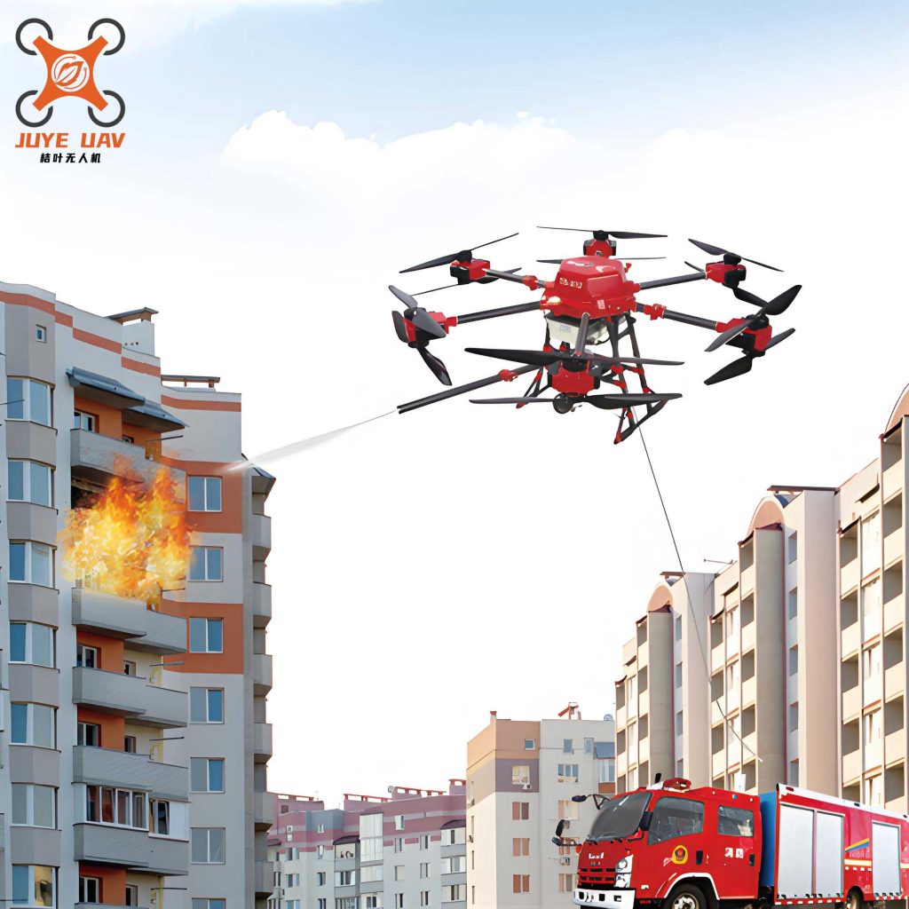
The image above depicts a specialized fire UAV, likely equipped with thermal imaging and payload release mechanisms, exemplifying the technological pivot towards autonomous aerial firefighting and monitoring assets.
Prevention and Early Detection
The adage “a minute saved is an acre preserved” underscores the critical importance of early detection. Fire UAV systems excel in this domain.
- Patrol and Monitoring: UAVs can be programmed for autonomous patrols over high-risk areas, providing persistent surveillance beyond the line-of-sight of fixed towers.
- Multi-Spectral Detection: By integrating visible-light and thermal infrared (TIR) cameras, a fire UAV can detect the first wisps of smoke and the associated heat signature long before the fire becomes a major conflagration. Advanced onboard AI can process this imagery in real-time to automatically identify and geolocate potential ignitions, triggering immediate alerts.
Active Firefighting Support and Suppression
During an active wildfire, fire UAV systems provide indispensable intelligence and direct intervention capabilities.
- Real-Time Situational Awareness: UAVs provide live video and thermal feeds to incident commanders, mapping fire perimeter progression, spotting spot fires, and identifying safe routes for ground crews. Thermal imaging is crucial for seeing through smoke and identifying hot spots. The rate of fire spread $R$ can be estimated from sequential geotagged images, informing models like the Rothermel surface fire spread model: $$R = \frac{I_R \xi (1+\phi_w)}{\rho_b \epsilon Q_{ig}}$$ where $I_R$ is reaction intensity, $\xi$ is propagating flux ratio, $\phi_w$ is wind factor, $\rho_b$ is fuel bulk density, $\epsilon$ is effective heating number, and $Q_{ig}$ is heat of preignition.
- Payload Delivery: Heavy-lift fire UAV platforms can deliver fire retardants, water, or suppressant gels to precise locations. This is especially valuable for creating containment lines in difficult terrain or for directly attacking small spot fires ahead of the main front.
- Communication Relay: In remote burn areas where communication infrastructure is damaged or non-existent, UAVs can act as airborne communication nodes, maintaining vital radio contact between firefighting teams.
Post-Fire Assessment and Rehabilitation
After a fire is contained, UAVs rapidly and safely assess the damage and guide recovery efforts.
- Burn Severity Mapping: Using differences in pre-fire and post-fire multispectral imagery (e.g., via the Differenced Normalized Burn Ratio – dNBR), UAVs create detailed maps of burn severity across the landscape. This is essential for planning erosion control, replanting, and habitat restoration.
- Spot Check for Smoldering Combustion: Thermal cameras on fire UAV systems are used to identify lingering hot spots that could reignite, ensuring the fire is completely extinguished.
| Mission Phase | Primary UAV Role | Key Sensor/Payload | Data/Output |
|---|---|---|---|
| Prevention & Detection | Persistent Surveillance | Visible Camera, Thermal (TIR) Camera, AI Processor | Automatic smoke/heat detection alerts, patrol logs |
| Active Response | Situational Awareness & Targeting | High-Zoom Visual, High-Res TIR, Data Link | Live fire perimeter maps, hotspot locations, crew safety monitoring |
| Active Response | Direct Suppression | Retardant/Water Tank, Precision Release Mechanism | Targeted application of suppressants on key flanks or spot fires |
| Post-Fire | Damage Assessment | Multispectral Camera, TIR Camera | Burn severity index maps (dNBR), residual hotspot maps |
4. Wildlife Conservation and Biodiversity Monitoring
UAVs offer a non-invasive method for studying and protecting fauna and flora, minimizing human disturbance to sensitive ecosystems.
- Population Surveys: UAVs with thermal cameras are exceptionally effective for nocturnal animal counts or for detecting species camouflaged in dense vegetation, as body heat contrasts with the cooler environment. Automated counting algorithms can process this imagery.
- Anti-Poaching Patrols: Similar to enforcement against illegal logging, UAVs conduct stealthy patrols over protected areas to detect and deter poachers, providing rangers with real-time intelligence.
- Habitat Mapping and Assessment: High-resolution imagery is used to map and monitor critical habitats (e.g., nesting sites, wetlands), track changes over time, and assess the impact of disturbances or management actions.
Persistent Challenges and Barriers to Integration
Despite the clear advantages, the widespread and deep integration of UAVs, particularly robust fire UAV systems, into forestry faces several interconnected challenges.
| Challenge Category | Specific Issues | Impact on Operations |
|---|---|---|
| Technical & Operational | Limited flight endurance/battery life; Payload capacity vs. flight time trade-off; Signal loss in dense canopy or mountainous terrain; Vulnerability to adverse weather (high wind, rain). | Restricts area covered per mission; limits equipment carried; risks data loss or UAV loss; causes mission cancellations. |
| Environmental Complexity | Navigating dense, unstructured 3D forest environments; Dynamic obstacles (animals, falling branches); Highly variable lighting conditions under canopy. | Requires advanced obstacle avoidance and path planning AI; complicates automated image analysis and consistency. |
| Data Processing & Analysis | Large volumes of imagery/data generated; Need for specialized AI/ML expertise for automated analysis; Lack of standardized processing pipelines. | Creates data bottlenecks; limits real-time application; hinders reproducibility and scaling of solutions. |
| Regulatory & Economic | Restrictive airspace regulations (BVLOS restrictions); High initial investment for advanced systems (e.g., LiDAR, heavy-lift fire UAV); Lack of unified industry standards for data and operations. | Constrains operational scope, especially for large-area patrols; limits access for smaller organizations; impedes interoperability and data sharing. |
Future Trajectories and Concluding Synthesis
The future of UAVs in forestry lies in increased autonomy, intelligence, and specialized design. Key development vectors include:
- Advanced Autonomy and Swarm Intelligence: Future systems will feature enhanced onboard processing for real-time decision-making, enabling fully autonomous beyond-visual-line-of-sight (BVLOS) missions. Swarms of cooperating UAVs, including specialized fire UAV units working in tandem with mapping drones, could simultaneously map a fire, deliver suppressants, and monitor crew safety.
- Integrated Sensor Suites and AI: The fusion of data from LiDAR, hyperspectral, thermal, and RGB sensors on a single platform, processed by sophisticated AI, will enable holistic forest characterization—simultaneously assessing structure, species composition, health, and threats like fire risk or disease.
- Purpose-Built Airframes for Forestry: Development of UAVs specifically designed for the forest environment, such as hybrid vertical take-off and landing (VTOL) fixed-wing models for endurance and agility, or ruggedized multi-rotors with enhanced obstacle avoidance for under-canopy navigation.
- Regulatory Evolution and Ecosystem Development: Progressive regulations that facilitate safe BVLOS operations are essential. Concurrently, fostering an ecosystem of service providers, data analysts, and standardized training will lower barriers to adoption and maximize the technology’s societal benefit.
In conclusion, the synergy between UAV technology and forestry management is profoundly reshaping the stewardship of our forest landscapes. From the granular precision of individual tree measurement to the life-and-death macro-scale dynamics of wildfire combat, UAVs provide a versatile, powerful, and increasingly indispensable toolkit. The specialized fire UAV stands out as a critical innovation in this suite, directly addressing one of the most urgent and destructive challenges facing global forests. By continuing to innovate in autonomy, sensor fusion, and airframe design while navigating regulatory and economic hurdles, the forestry sector can fully harness this technological revolution. The trajectory points unequivocally towards an intelligent, responsive, and resilient future for forest management, where UAVs are not merely tools but integral components of a connected, data-centric ecosystem safeguarding these vital natural resources.