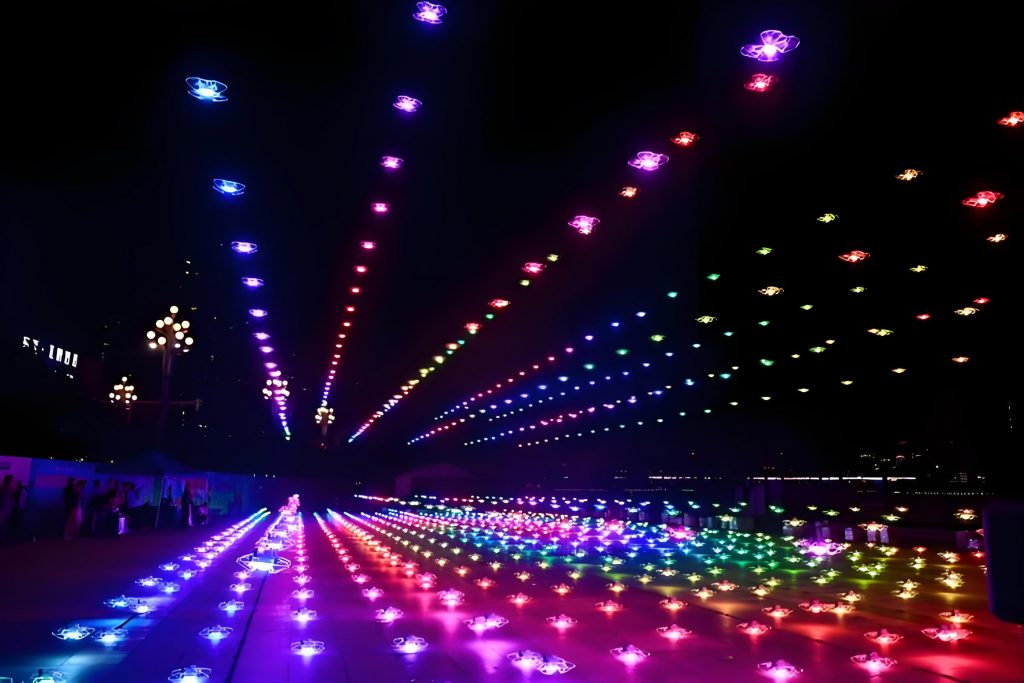
As a member of the radio security assurance team, I was directly involved in ensuring the success of a massive drone show event that captivated audiences and set new benchmarks in the industry. This drone show, featuring over 10,000 unmanned aerial vehicles (UAVs), was a spectacular display of technology and art, designed to celebrate a national occasion. The sheer scale of this UAV show necessitated meticulous planning and execution to prevent any radio frequency interference, which could have disrupted the performance. In this account, I will detail our comprehensive approach, from pre-event assessments to real-time monitoring, highlighting the strategies and technologies that safeguarded the electromagnetic environment. Throughout this process, we emphasized the importance of radio security for such large-scale drone shows, and I will share insights into the challenges and solutions we implemented, supported by data, tables, and theoretical models.
The drone show was orchestrated as a grand visual spectacle, with the theme centered on innovation and possibility. This UAV show involved the simultaneous flight of thousands of drones, each requiring precise control through radio communication links. Our team’s primary responsibility was to monitor and protect the dedicated frequency bands used for high-precision positioning, navigation, and communication control. These bands are critical for coordinating the intricate formations and light patterns that define a successful drone show. To achieve this, we conducted extensive pre-event analyses, identifying potential interference risks and developing a robust monitoring plan. The success of this UAV show relied on a clear electromagnetic spectrum, free from external disruptions, and our efforts ensured that the performance proceeded flawlessly, earning widespread acclaim.
In the weeks leading up to the drone show, our team engaged in deep consultations with the UAV show operators to understand their technical requirements and operational protocols. We analyzed high-risk points for radio interference, such as crowded urban areas and existing communication infrastructures. Based on this, we formulated a detailed monitoring scheme that included both fixed stations and mobile units. For instance, we used the following table to summarize the key frequency bands and their purposes, which helped in allocating resources effectively:
| Frequency Band (MHz) | Primary Use | Potential Interference Sources | Number of Signals Analyzed |
|---|---|---|---|
| 1575.42 (GPS L1) | High-precision positioning for UAV navigation | Other GPS devices, urban multipath effects | 15 |
| 2400-2483.5 | Communication control and data links | Wi-Fi networks, Bluetooth devices | 12 |
| 5800-5900 | Additional positioning and backup control | Microwave ovens, industrial equipment | 9 |
This table illustrates the breadth of our monitoring efforts, which covered essential aspects of the drone show’s operation. By categorizing the frequency bands, we could prioritize our surveillance and respond swiftly to any anomalies. The UAV show’s complexity meant that even minor interference could lead to cascading failures, so we employed mathematical models to predict and mitigate risks. One key formula we used relates to the received signal power in free space, which is fundamental to understanding potential interference:
$$ P_r = P_t G_t G_r \left( \frac{\lambda}{4\pi d} \right)^2 $$
Here, \( P_r \) represents the received power, \( P_t \) is the transmitted power, \( G_t \) and \( G_r \) are the antenna gains of the transmitter and receiver, respectively, \( \lambda \) is the wavelength, and \( d \) is the distance between the transmitter and receiver. This equation helped us estimate the signal strength for the drone show’s control links and identify areas where external signals might overpower the UAV communications. For example, in dense urban environments, reflections and obstructions could alter this ideal model, so we incorporated additional factors like path loss exponent \( n \) in a modified version:
$$ P_r = P_t G_t G_r \left( \frac{\lambda}{4\pi d} \right)^n $$
where \( n \) typically ranges from 2 for free space to 4 or higher for urban areas. By applying this, we could assess the resilience of the UAV show’s radio links and recommend optimal transmitter placements to minimize interference risks.
Prior to the drone show, we activated fixed monitoring stations and deployed mobile vehicles equipped with advanced spectrum analyzers. These tools allowed us to conduct protective monitoring of the key frequency bands, identifying and evaluating potential interference sources. We provided the UAV show team with recommendations on spectrum usage and station configurations, ensuring that their operations aligned with regulatory requirements. Our pre-event assessments involved scanning for unauthorized transmissions and coordinating with local authorities to mitigate any conflicts. This proactive approach was crucial for the drone show’s success, as it prevented last-minute issues that could have compromised the performance. The following table outlines the types of equipment and their roles in our monitoring strategy:
| Equipment Type | Function | Deployment Location | Key Metrics Monitored |
|---|---|---|---|
| Fixed Monitoring Station | Continuous spectrum surveillance | Strategic high points in the city | Signal strength, bandwidth occupancy |
| Mobile Monitoring Vehicle | On-the-go interference detection | Areas near the drone show site | Real-time signal analysis, geolocation of sources |
| Portable Spectrum Analyzer | Targeted frequency checks | On-site with the UAV team | Specific frequency purity, modulation quality |
During the actual drone show, our team intensified monitoring efforts, focusing on the dedicated bands for high-precision positioning, navigation, and communication control. We analyzed 36 suspicious radio signals in real-time, none of which resulted in interference, thanks to our preemptive measures. This UAV show demonstrated the importance of robust radio security frameworks for large-scale events. To quantify the interference potential, we used a threshold model based on the signal-to-interference ratio (SIR), which is critical for maintaining reliable communication in a drone show:
$$ \text{SIR} = \frac{P_{\text{signal}}}{P_{\text{interference}}} $$
where \( P_{\text{signal}} \) is the power of the desired signal from the UAV control system, and \( P_{\text{interference}} \) is the power of any interfering signal. For the drone show to operate smoothly, we ensured that SIR remained above a minimum threshold, typically set at 10 dB for critical control links. This involved continuous monitoring and rapid response to any deviations, highlighting the dynamic nature of radio security in a live UAV show environment.
Beyond the technical aspects, our work involved collaboration with multiple stakeholders, including local government agencies and the public, to raise awareness about spectrum usage during the drone show. We conducted briefings on the importance of avoiding unauthorized transmissions in the vicinity, which helped reduce accidental interference. The success of this UAV show has set a precedent for future events, emphasizing the need for integrated radio security plans. In reflecting on this experience, I can attest to the critical role of advanced monitoring and theoretical models in safeguarding large-scale drone shows. The following formula, which describes the probability of interference in a crowded spectrum, was instrumental in our risk assessment:
$$ P_{\text{interference}} = 1 – e^{-\lambda A} $$
Here, \( P_{\text{interference}} \) is the probability of at least one interference event, \( \lambda \) is the density of potential interferers per unit area, and \( A \) is the area of coverage for the drone show. By estimating \( \lambda \) from historical data and current spectrum scans, we could predict and mitigate interference risks for the UAV show. This probabilistic approach, combined with real-time data, allowed us to maintain a high level of assurance throughout the event.
In conclusion, the radio security assurance for this drone show was a multifaceted endeavor that blended technology, strategy, and collaboration. The UAV show not only achieved its artistic and technical goals but also reinforced the importance of electromagnetic spectrum management in modern public events. Our team’s efforts in monitoring, analyzing, and responding to potential threats ensured a seamless experience for all spectators. As drone shows continue to grow in scale and complexity, the lessons learned from this UAV show will inform best practices for future initiatives, promoting safer and more reliable performances. The integration of tables, formulas, and real-world applications, as shared in this account, underscores the depth of planning required for such ambitious projects.
Looking ahead, we are exploring enhancements to our radio security protocols for upcoming drone shows, including the use of artificial intelligence for predictive interference modeling and automated response systems. The UAV show industry is evolving rapidly, and our commitment to innovation ensures that we stay ahead of potential challenges. By continuing to refine our approaches, we aim to support even larger and more intricate drone shows, pushing the boundaries of what is possible in aerial displays. This journey has been immensely rewarding, and I am proud to have contributed to the success of such a groundbreaking UAV show, setting new standards for safety and performance in the field.