
The integration of technology into modern policing strategies represents a paradigm shift in public security management. Among these technological advancements, the police Unmanned Aerial Vehicle (UAV) has emerged as a pivotal asset, particularly in environments where traditional methods falter. This article explores, from a first-person research perspective, the profound impact and operational methodologies of police UAV deployment in maintaining public order during the annual caterpillar fungus harvesting season in high-altitude regions. The unique geographical and sociological challenges of these areas provide a compelling case study for the capabilities of these systems.
The highland plateau, with an average elevation exceeding 4000 meters, hosts a fragile ecosystem and a valuable natural resource: *Ophiocordyceps sinensis*, known as caterpillar fungus. Its harvest, concentrated in a brief annual window, triggers a massive, transient influx of people into remote, ecologically sensitive, and geographically complex terrain. This convergence creates a perfect storm of public security challenges—managing large crowds, preventing boundary and economic disputes, deterring illegal harvesting, ensuring personal safety, and protecting the environment—all within a context of limited police personnel and infrastructure. Traditional ground-based patrols and response mechanisms are severely hampered by non-existent roads, treacherous mountain paths, and the sheer vastness of the harvesting zones. It is within this operational gap that the police UAV demonstrates its indispensable value.
1. Research Context and Significance
1.1 Operational Background and Challenges
The primary challenge is multidimensional, stemming from environment, demography, and resource constraints.
Environmental & Logistical Hurdles: Harvesting sites are typically located in alpine meadows, valleys, and mountain slopes at altitudes between 4500m and 5000m. Access is often limited to footpaths or rudimentary tracks impassable to standard vehicles. The terrain is prone to sudden weather changes, landslides, and rockfalls, isolating communities and hindering rapid police deployment. Communication networks are unreliable or non-existent in these remote pockets, breaking the critical link between frontline officers and command centers.
Demographic Complexity: The harvesting season sees a confluence of local nomadic herders and external harvesters from various regions. This transient population, living in temporary tent settlements, presents significant difficulties in identity verification, behavior monitoring, and crowd dynamics management. The potential for conflicts over harvesting boundaries, theft, and fraudulent trade is high.
Resource Scarcity: The “vast land, few officers” dichotomy is acutely felt. Police forces are stretched thin, unable to provide comprehensive ground coverage for patrol, surveillance, and immediate response across hundreds of dispersed harvesting sites simultaneously. This strain impacts all aspects of law enforcement, from crime prevention to ecological protection.
| Challenge Category | Specific Manifestations | Impact on Policing |
|---|---|---|
| Geographical | Extreme altitude, complex terrain (mountains, valleys), lack of roads, severe weather, natural disasters. | Severely impedes mobility, delays response, causes communication blackouts. |
| Demographic | Large, transient population; diverse origins; temporary encampments; high population density in remote areas. | Complicates identity management, crowd control, and increases dispute potential. |
| Resource-Based | Limited police personnel; vast area to patrol; inadequate ground transport for terrain. | Leads to patrol盲区 (blind spots), slow emergency response, and officer fatigue. |
| Ecological | Fragile grassland ecosystem; damage from improper digging; risk of desertification. | Requires active monitoring and enforcement of environmental regulations, adding to police duties. |
1.2 Strategic Significance of Police UAV Integration
The deployment of police UAVs is not merely a technical upgrade but a strategic necessity. Its significance can be encapsulated in the following transformative contributions:
- Force Multiplier: A single police UAV unit can monitor an area that would require dozens of officers on foot, effectively amplifying the presence and coverage of limited police resources.
- Situational Awareness Dominance: It provides a persistent, bird’s-eye view of the operational environment, transmitting real-time video and data to command centers, thus enabling data-driven decision-making.
- Rapid Response Enabler: It dramatically reduces the time between incident occurrence and first assessment, often reaching locations in minutes that would take hours by ground.
- Deterrence and Prevention: The visible presence of a police UAV patrol serves as a powerful deterrent against illegal activities and encourages compliance among harvesters.
- Ecological Stewardship Support: It facilitates the monitoring of harvesting practices, identification of illegal zones, and assessment of environmental damage, aiding in sustainable resource management.
The operational model can be conceptualized as enhancing traditional capabilities through an aerial layer. If ‘P’ represents traditional police effectiveness and ‘U’ represents the enhancement factor provided by UAVs, the new operational effectiveness ‘E’ can be modeled as a non-linear improvement:
$$E = P \times e^{U(t, c, d)}$$
where \(U\) is a function of time savings (\(t\)), area coverage (\(c\)), and data fidelity (\(d\)).
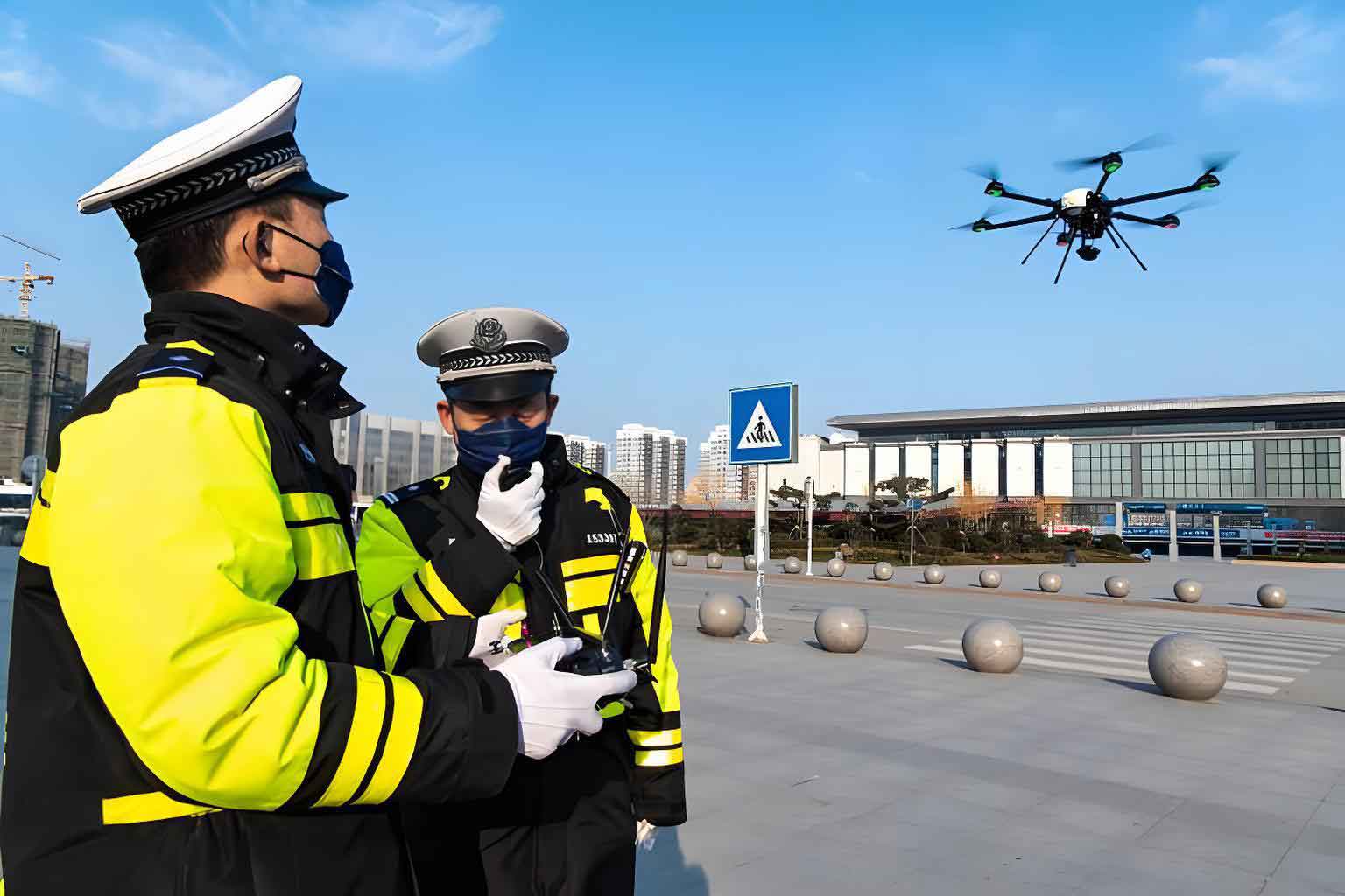
2. Technical Advantages and Operational Configurations of Police UAVs
The efficacy of police UAVs in highland missions is rooted in their technical specifications and adaptable configurations. Two primary airframe types are utilized, each with distinct advantages.
| Platform Type | Key Strengths | Ideal Mission Profile | Highland Operational Considerations |
|---|---|---|---|
| Multi-Rotor (e.g., Quadcopter, Hexacopter) | Vertical Take-Off and Landing (VTOL), excellent hover stability, high maneuverability in confined spaces. | Close-range surveillance, detailed inspection, evidence collection, search & rescue in complex terrain, targeted loudspeaker announcement. | Excellent for patrolling specific valleys, monitoring encampments, and investigating incidents at precise GPS coordinates. Battery life is a limiting factor. |
| Fixed-Wing | Long endurance (several hours), high cruising speed, large area coverage per flight. | Broad-area reconnaissance, route surveillance, mapping of vast harvesting zones, rapid response to distant alerts. | Ideal for initial daily survey of large sectors. Requires a small, clear area for launch and recovery (e.g., catapult launch, net recovery). |
| Hybrid VTOL (Vertical Take-Off & Landing Fixed-Wing) | Combines VTOL convenience with fixed-wing endurance and speed. | Versatile missions requiring both deep penetration and detailed loitering capability without runway. | The optimal but more expensive solution, eliminating runway dependency while maximizing coverage and on-station time. |
The mission payload is what transforms the platform into a powerful police tool. A standard highland mission kit includes:
- Electro-Optical/Infrared (EO/IR) Gimbal: A high-resolution zoom camera for daytime detail and a thermal imaging camera for night operations, poor visibility, or detecting individuals attempting to hide.
- Aerial Loudspeaker: For broadcasting warnings, instructions, or public service announcements directly to crowds on the ground.
- Emergency Payload Drop Module: Can deliver small medical supplies, communication devices, or other critical items to stranded or injured individuals.
- Real-Time Kinematic (RTK) Positioning System: Provides centimeter-level GPS accuracy, crucial for precise mapping, evidence location marking, and guiding ground teams.
- Long-Range Data Link: Ensures stable command, control, and video transmission over distances of 10-20 km, overcoming line-of-sight obstacles common in mountainous regions.
The operational range and endurance are critical metrics. For a police UAV performing a grid patrol over a harvesting zone, the effective coverage area \(A_{cov}\) can be approximated by:
$$A_{cov} = v \cdot t \cdot w \cdot \eta$$
where \(v\) is the patrol speed, \(t\) is the flight endurance, \(w\) is the sensor swath width (field of view at patrol altitude), and \(\eta\) is an efficiency factor accounting for turns and terrain following. Compared to a ground patrol speed \(v_g\), the police UAV’s area coverage efficiency ratio \(R\) is:
$$R = \frac{A_{cov_{UAV}}}{A_{cov_{ground}}} = \frac{v_{UAV} \cdot t_{UAV} \cdot w_{UAV} \cdot \eta_{UAV}}{v_{g} \cdot t_{g} \cdot w_{g} \cdot \eta_{g}}$$
Given that \(v_{UAV} >> v_g\), \(w_{UAV} >> w_g\), and often \(t_{UAV} > t_g\) for area search, \(R\) is typically a large number, quantitatively demonstrating the force multiplication effect.
3. Application Paradigms in Harvest Season Policing
3.1 Aerial Patrol and Dynamic Monitoring
This is the most fundamental and impactful application. Police UAVs conduct scheduled and random patrols along pre-programmed or manually piloted routes over harvesting zones.
Procedure: A flight plan is charted to cover areas of interest, such as zone boundaries, dense encampments, and known dispute-prone locations. The police UAV, equipped with its EO/IR payload, streams live footage to the command vehicle or headquarters. Operators monitor for anomalies: large unauthorized gatherings, movements into restricted or closed areas, signs of altercations, or unusual vehicular activity on access tracks.
Outcome: This creates a persistent “eye in the sky,” eliminating blind spots. The mere awareness of police UAV surveillance has a profound calming and regulatory effect on the harvesters. It allows a small number of commanders to maintain a comprehensive understanding of the real-time situation across a wide area, something impossible with ground reports alone.
3.2 Investigation and Evidence Collection
When incidents such as theft, assault, or boundary violations occur, the police UAV serves as a rapid-response forensic tool.
Procedure: Upon alert, the nearest police UAV is dispatched to the coordinates. It documents the scene from multiple angles and altitudes before any ground disturbance occurs. High-resolution photographs and orthomosaic maps are created. For example, in a tent theft case, the UAV can meticulously document footprints, tool marks, and the overall scene layout. In a boundary dispute, it can capture the spatial relationship between arguing parties and the contested terrain feature.
Outcome: This provides objective, geotagged visual evidence that is admissible in legal proceedings. It preserves the scene’s integrity and allows investigators to analyze the event remotely and plan their ground approach strategically. The efficiency gain is quantified by the reduced “scene processing time.” If traditional methods take time \(T_t\), and police UAV-assisted methods take \(T_u\), the time saved \(\Delta T\) is:
$$\Delta T = T_t – T_u$$
where \(T_u\) includes UAV flight time and data processing, which is often significantly less than the time for a ground team to physically reach and process a remote scene.
3.3 Emergency Response and Search Coordination
Medical emergencies, lost individuals, or conflicts escalating into violence require immediate intervention.
Procedure: The police UAV’s speed allows it to be the first “responder” on the scene. With its thermal camera, it can quickly locate a lost or injured person in vegetation or rocky terrain, day or night. It can assess the scale of a fight or accident, allowing commanders to gauge the necessary force level for the ground team. The loudspeaker can be used to issue clear instructions (“Disperse,” “Medical help is coming,” “Stay where you are”) to de-escalate situations or guide the lost.
Outcome: This dramatically improves outcomes for emergencies. The reduced response time for assessment and initial action can be life-saving. It also protects ground officers by providing critical situational awareness before they enter a potentially volatile scene.
3.4 Ecological Protection and Compliance Enforcement
Sustainable harvesting is a key government objective. Police UAVs monitor for practices that damage the grassland, such as digging outside permitted times, using large tools that destroy turf, or harvesting in protected or rotation-rested areas.
Procedure: Regular aerial surveys create a baseline map of the harvesting zone. Subsequent flights compare the current state to this baseline, identifying new digging pits, unauthorized tent sites in ecologically sensitive areas (like near water sources), or the formation of illegal access trails. Thermal imaging can even detect the heat signatures of clandestine digging activities at night.
Outcome: This enables proactive and precise enforcement of environmental regulations. Authorities can issue warnings or dispatch teams directly to the exact location of the violation. Over time, aerial imagery data can be analyzed to assess the environmental impact of the season and inform future management policies. The deterrence effect discourages destructive practices, contributing directly to the long-term sustainability of the resource.
| Operational Phase | Police UAV Application | Key Technology Used | Measurable Benefit |
|---|---|---|---|
| Prevention & Routine Patrol | Broad-area reconnaissance, crowd monitoring, deterrence display. | Fixed-wing/Hybrid UAV, EO Camera, Live Video Downlink. | % reduction in patrol盲区; Deterrence index (correlation with reduced incident reports). |
| Incident Response | Rapid scene assessment, evidence locking, suspect tracking. | Multi-rotor UAV, EO/IR Gimbal, RTK GPS. | Reduction in first-response time (\(\Delta T\)); Increase in evidence quality/ completeness. |
| Public Interaction & Communication | Broadcasting announcements, guiding lost persons, crisis negotiation. | Aerial Loudspeaker, Stable Hover. | Increased reach of broadcasts; Success rate in locating missing persons. |
| Environmental Oversight | Monitoring digging practices, enforcing zone closures, mapping ecological impact. | High-res camera, Photogrammetry software, Thermal camera. | Number of environmental violations detected; Hectares of illegally harvested area identified. |
| Command & Control | Providing real-time overall operational picture to headquarters. | Data Link, Video Feed Integration into C2 system. | Improved decision-making speed and accuracy (reduced OODA loop time). |
4. Integrated Operational Model and Future Evolution
The true power of the police UAV is realized not in isolation, but as the aerial node in an integrated “Air-Ground” policing network. The model functions as follows:
- Detection: The police UAV patrols and detects an anomaly (e.g., a fight, illegal digging).
- Diagnosis & Decision: The live feed is analyzed at the command center. A decision is made (e.g., dispatch ground team, issue aerial warning).
- Direction: The UAV operator uses the UAV’s loudspeaker for initial intervention or relays precise GPS coordinates and the optimal approach route to the ground team.
- Action: The ground team, informed and guided, moves efficiently to the exact location to handle the situation.
- Post-Action Documentation: The police UAV continues to document the resolution process and the final state of the scene.
This model creates a synergistic loop where the police UAV extends the senses and reach of the ground force, while the ground force provides the physical authority and intervention capability that the UAV lacks. The system’s overall effectiveness \(E_{sys}\) can be seen as greater than the sum of its parts:
$$E_{sys} = \alpha \cdot E_{UAV} + \beta \cdot E_{Ground} + \gamma \cdot (E_{UAV} \cdot E_{Ground})$$
where \(\alpha\) and \(\beta\) are weighting factors, and the cross-term \(\gamma \cdot (E_{UAV} \cdot E_{Ground})\) represents the synergy gain from integration.
The future evolution of police UAVs in such demanding environments points towards greater autonomy and intelligence. Key trends include:
- AI-Powered Analytics: Onboard or ground-based AI algorithms that can automatically detect specific behaviors (e.g., fighting, digging, large crowd formation) from the video feed, alerting operators to potential incidents.
- Swarm Technology: Coordinated fleets of smaller, cheaper police UAVs working together to blanket an enormous area with sensors, providing redundant coverage and multiple viewing angles.
- Enhanced Endurance: Advancements in hydrogen fuel cells or hybrid gasoline-electric systems to extend flight times from hours to days for fixed-wing models, enabling truly persistent surveillance.
- Integrated Sensor Suites: Adding capabilities like methane sniffers for fire detection, multispectral cameras for plant health assessment (related to digging impact), or automated license plate recognition on access roads.
- Seamless C4ISR Integration: Direct fusion of police UAV data into the police force’s Command, Control, Communications, Computers, Intelligence, Surveillance, and Reconnaissance architecture, making the aerial feed a standard layer on every commander’s digital map.
5. Conclusion
The deployment of police UAVs for public security management during the highland caterpillar fungus harvest is a quintessential example of technology addressing a specific, acute operational deficit. By overcoming the tyranny of distance and terrain, these systems have redefined what is possible with limited human resources. The police UAV provides unmatched situational awareness, acts as a potent deterrent, enables rapid and precise response, and supports the crucial goal of ecological conservation. It transforms the policing model from reactive and ground-bound to proactive, integrated, and spatially dominant.
The quantitative advantages in coverage area, response time, and evidence quality are clear. As the technology continues to evolve towards greater autonomy, intelligence, and endurance, the role of the police UAV will only become more central. It represents a sustainable and scalable solution for managing large-scale public events in geographically challenging environments worldwide, proving that in modern law enforcement, altitude often translates to strategic advantage. The successful integration of the police UAV in this context is a blueprint for its application in other areas where geography, limited resources, and public safety intersect.