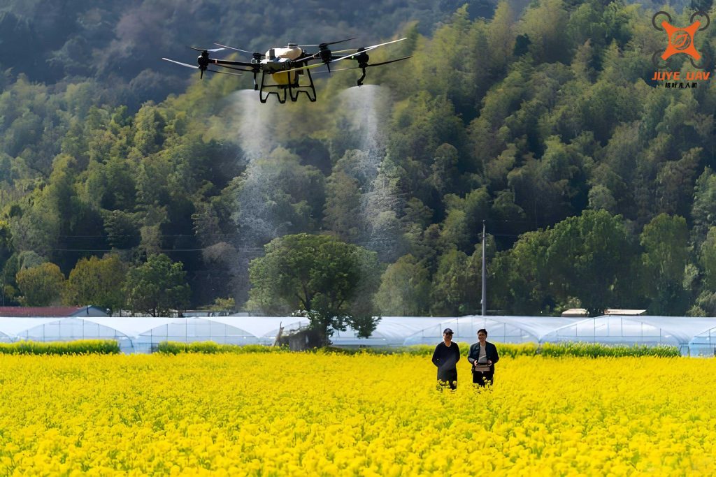
As an emerging technology in modern agriculture, agricultural UAVs have garnered significant attention for their potential to revolutionize farming practices, especially in challenging terrains like mountainous regions. In this article, I will explore the role of agricultural UAVs in driving smart agriculture development in hilly and mountainous areas, based on current trends, challenges, and future pathways. My analysis aims to provide insights into how these unmanned aerial vehicles can overcome obstacles and enhance agricultural productivity sustainably.
The concept of smart agriculture integrates advanced technologies such as the Internet of Things (IoT), big data, and artificial intelligence to optimize farming operations. In mountainous areas, where traditional machinery faces limitations due to rugged terrain and fragmented land plots, agricultural UAVs offer a promising solution. These drones are designed for precision tasks like crop spraying, monitoring, and data collection, making them a key component of the smart agriculture ecosystem. Throughout this discussion, I will emphasize the importance of agricultural UAVs in addressing the unique needs of these regions.
To set the context, let’s consider the global shift towards digital agriculture. Countries worldwide are investing in smart farming technologies to improve food security and resource efficiency. In China, for instance, mountainous areas account for approximately 60% of the land area and contribute significantly to agricultural output, yet they lag in mechanization levels. The adoption of agricultural UAVs can bridge this gap by enabling precision agriculture, reducing labor costs, and minimizing environmental impact. As I delve deeper, I will analyze the current state, challenges, and strategic paths for leveraging agricultural UAVs in these regions.
Current Development Status of Agricultural UAVs in Mountainous Areas
The market for agricultural UAVs has expanded rapidly in recent years, driven by technological advancements and supportive policies. In mountainous regions, the demand is particularly high due to the limitations of conventional farming methods. Below, I present a table summarizing key market indicators for agricultural UAVs in such areas.
| Indicator | Value/Description | Impact on Mountainous Agriculture |
|---|---|---|
| Market Size Growth Rate | Annual growth of 20-30% since 2020 | Reflects increasing adoption and investment in agricultural UAVs |
| Primary Applications | Crop spraying, field mapping, pest monitoring | Enhances precision and efficiency in fragmented plots |
| Key Players | Companies like DJI, XAG, and other specialized firms | Drives innovation and competitive pricing for agricultural UAVs |
| Geographic Coverage | Focus on hilly regions in Asia, Europe, and North America | Addresses terrain-specific challenges through customized solutions |
From a policy perspective, governments have introduced various initiatives to promote agricultural UAVs. For example, subsidy programs and regulatory frameworks aim to reduce financial barriers and ensure safe operations. In China, policies such as the “Digital Village Development Action Plan” emphasize the integration of UAVs into smart agriculture. These efforts are crucial for scaling up the use of agricultural UAVs in mountainous areas, where economic constraints often hinder adoption. As I analyze further, it’s clear that both market forces and policy support are shaping the trajectory of agricultural UAVs.
To quantify the efficiency gains, consider a formula for the operational cost-effectiveness of agricultural UAVs compared to manual labor. Let $C_m$ represent the cost per hectare for manual spraying, $C_u$ for UAV-based spraying, and $E$ the efficiency factor due to reduced time and resource use. The cost savings $S$ can be expressed as:
$$ S = C_m – C_u \cdot E $$
where $E$ is typically greater than 1 for agricultural UAVs, indicating higher efficiency. For instance, in mountainous terrains, $E$ may range from 2 to 5, depending on factors like slope and crop type. This formula highlights how agricultural UAVs can lower expenses while improving output.
Challenges in Deploying Agricultural UAVs in Mountainous Regions
Despite their potential, agricultural UAVs face several obstacles in mountainous areas. I will categorize these into economic, regulatory, and technical challenges, using a table to illustrate them.
| Challenge Category | Specific Issues | Impact on Agricultural UAV Adoption |
|---|---|---|
| Economic Barriers | High initial costs, low farmer income, small plot sizes | Reduces affordability and return on investment for agricultural UAVs |
| Regulatory Gaps | Lack of standardized production norms, safety protocols, and flight permissions | Increases operational risks and limits widespread use of agricultural UAVs |
| Technical Limitations | Battery life constraints, payload capacity, and adaptability to complex terrain | Hinders performance and reliability of agricultural UAVs in steep areas |
| Knowledge and Training | Limited awareness and skills among farmers for operating agricultural UAVs | Slows down adoption and effective utilization of the technology |
From my perspective, these challenges are interconnected. For instance, the high cost of agricultural UAVs exacerbates the economic divide in mountainous communities, while technical flaws like short battery life reduce their practicality for large-scale farming. To address this, I propose a mathematical model for optimizing UAV battery usage. Let $B$ be the battery capacity (in watt-hours), $P$ the power consumption rate (in watts), and $T$ the flight time (in hours). The relationship is given by:
$$ T = \frac{B}{P} $$
For agricultural UAVs operating in mountainous regions, $P$ tends to increase due to elevation changes and wind resistance, leading to shorter $T$. Innovations in battery technology or energy-efficient designs are essential to enhance $T$ and make agricultural UAVs more viable.
Another critical issue is pesticide drift, which can be modeled using fluid dynamics equations. The drift distance $D$ of spray droplets from an agricultural UAV depends on factors like wind speed $v_w$, nozzle design, and flight altitude $h$. A simplified formula is:
$$ D = k \cdot v_w \cdot h $$
where $k$ is a constant based on environmental conditions. Minimizing $D$ is crucial for precision agriculture, requiring advanced control systems in agricultural UAVs to adjust parameters in real-time.
Strategic Pathways for Enhancing Agricultural UAV Integration
To overcome these challenges, I suggest three main pathways: developing tailored regulatory models, implementing information management systems, and focusing on technological innovation. Each pathway can be elaborated with examples and quantitative measures.
First, building a regulatory framework specific to mountainous areas is vital. This involves setting standards for agricultural UAV production, operation, and safety. For instance, governments could mandate geo-fencing and real-time monitoring for agricultural UAVs to prevent accidents in rugged terrains. A table below outlines potential regulatory components.
| Regulatory Component | Description | Expected Outcome for Agricultural UAVs |
|---|---|---|
| Production Standards | Guidelines for durability, payload, and weather resistance | Improved reliability and performance of agricultural UAVs |
| Operational Permits | Licensing systems for pilots and UAVs based on terrain complexity | Enhanced safety and compliance in mountainous operations |
| Subsidy Schemes | Financial incentives for farmers to adopt agricultural UAVs | Increased affordability and adoption rates |
Second, integrating agricultural UAVs into smart agriculture systems through information management platforms can boost efficiency. These platforms use IoT sensors and data analytics to optimize UAV missions. For example, an agricultural UAV can collect soil moisture data, which is then processed to recommend irrigation schedules. The effectiveness of such a system can be measured using a formula for data accuracy $A$, defined as:
$$ A = \frac{N_c}{N_t} $$
where $N_c$ is the number of correct predictions (e.g., pest outbreaks) and $N_t$ is the total predictions made by the system. High $A$ values indicate that agricultural UAVs contribute valuable insights for decision-making.
Third, technological innovation should focus on enhancing the capabilities of agricultural UAVs for mountainous environments. Key areas include battery life extension, obstacle avoidance, and payload optimization. Research and development investments can be prioritized using a cost-benefit analysis. Let $I$ represent the investment in innovation, $B_e$ the expected benefit (e.g., increased crop yield), and $R$ the risk factor. The net benefit $NB$ is:
$$ NB = B_e – I \cdot R $$
By targeting innovations with high $B_e$ and low $R$, stakeholders can maximize the impact of agricultural UAVs. For instance, developing solar-powered agricultural UAVs could reduce dependency on batteries and lower operational costs in remote areas.
Throughout these pathways, the repeated emphasis on agricultural UAVs underscores their centrality in transforming mountainous agriculture. By addressing regulatory, informational, and technical aspects, we can create an ecosystem where agricultural UAVs thrive and drive smart agriculture forward.
Conclusion and Future Outlook
In conclusion, agricultural UAVs hold immense potential for boosting smart agriculture in mountainous regions, but their success depends on overcoming existing barriers. Through my analysis, I have highlighted the importance of tailored regulations, integrated management systems, and continuous innovation. The use of formulas and tables in this article helps quantify the benefits and challenges, providing a clear roadmap for stakeholders.
Looking ahead, the evolution of agricultural UAVs will likely involve greater autonomy and connectivity with other smart farming tools. As technologies like 5G and AI advance, agricultural UAVs could become even more efficient at tasks such as real-time crop health assessment and automated spraying. I encourage policymakers, researchers, and farmers to collaborate in fostering an environment where agricultural UAVs can flourish, ultimately contributing to sustainable agriculture and rural development in mountainous areas.
To further illustrate the potential impact, consider a scenario where agricultural UAVs are deployed across a mountainous region with 1000 hectares of farmland. Assuming an average efficiency gain of 30% from UAV-based operations, the total cost savings could be significant. Let $Y$ be the yield per hectare, $C_s$ the savings per hectare, and $T_s$ the total savings. We can express this as:
$$ T_s = \sum_{i=1}^{1000} (C_s \cdot Y_i) $$
where $Y_i$ varies based on crop type and terrain. Such calculations demonstrate how widespread adoption of agricultural UAVs can lead to substantial economic benefits.
In summary, the journey toward smart agriculture in mountainous areas is intertwined with the progression of agricultural UAVs. By addressing the outlined pathways, we can unlock new levels of productivity and sustainability, ensuring that these regions remain vital contributors to global food security.