
The health and productivity of grassland ecosystems are fundamental to regional ecological security, biodiversity, and sustainable pastoral economies. As a vital component of terrestrial biomes, grasslands provide critical services including soil conservation, carbon sequestration, and forage production. However, these ecosystems are increasingly vulnerable to degradation driven by a complex interplay of climatic stressors, anthropogenic pressures, and biological threats. Among these, outbreaks of insect pests, rodent populations, and the proliferation of invasive or toxic plant species pose significant and recurring challenges to grassland management and restoration efforts worldwide. This article provides an in-depth analysis of the dynamics of grassland degradation and biohazards, followed by a detailed exploration of modern control strategies. A significant focus is placed on the transformative role of agricultural UAV technology, evaluating its technical advantages, economic feasibility, and ecological benefits compared to conventional ground-based methods. We synthesize current applications and propose a forward-looking framework for integrating intelligent, data-driven agricultural UAV systems into holistic grassland protection and precision conservation programs.
1. Grassland Ecosystem Status and Degradation Dynamics
Grasslands, ranging from temperate steppes to tropical savannas, cover approximately 40% of the Earth’s terrestrial surface. Their ecological equilibrium is delicate, often maintained under specific climatic conditions characterized by seasonal precipitation and temperature variations. The degradation of these ecosystems manifests primarily as reductions in vegetation cover, soil erosion, biodiversity loss, and diminished ecosystem service provision. A primary catalyst for this decline is the imbalance between herbivore pressure (both domestic and wild) and the regenerative capacity of the vegetation, frequently exacerbated by unsustainable land-use practices. Furthermore, climate change-induced alterations in precipitation patterns and temperature regimes are creating more favorable conditions for certain pest species while stressing native grass populations.
The proliferation of harmful biological agents—insects, rodents, and toxic plants—acts as both a symptom and an accelerator of grassland degradation. These agents often establish positive feedback loops: overgrazing or drought weakens dominant grasses, creating openings for invasive toxic plants to colonize; these plants may be unpalatable or harmful to livestock, leading to further selective grazing pressure on remaining desirable species; concurrently, reduced plant competition and altered soil structure can favor burrowing rodents or certain insect herbivores. The economic impact is direct, through loss of forage yield and livestock poisoning, and indirect, through the costs associated with rehabilitation efforts.
2. The Tripartite Challenge: Insects, Rodents, and Toxic Plants
2.1 Insect Pest Infestations
Grasshopper and locust outbreaks represent a classic and devastating form of grassland insect damage. Species such as the Mongolian grasshopper or various locusts can rapidly reach densities that consume virtually all green vegetation. Their impact is quantified by both population density and the resulting forage loss. The relationship between insect density (D, individuals/m²) and yield loss (YL, kg/ha) can be modeled linearly for a given species under specific conditions:
$$Y_L = \alpha \cdot D$$
where $\alpha$ is a species-specific consumption coefficient. Monitoring involves regular surveys of nymph and adult densities, as well as ootheca (egg pod) counts to predict future outbreak risks. Beyond direct consumption, heavy infestations stress plants, reducing their resilience and seed production, thereby impairing the grassland’s natural recovery potential.
2.2 Rodent Population Explosions
Burrowing rodents like zokors (Eospalax spp.) and voles (Microtus spp.) cause multifaceted damage. Their herbivory reduces plant biomass, but more insidiously, their tunneling activities disrupt root systems, alter soil hydrology, and create soil mounds that bury seedlings and alter micro-topography. The damage area can be estimated by the density of mounds or active burrows. The ecological impact extends beyond immediate forage loss to long-term changes in plant community composition, often favoring ruderal or toxic species adapted to disturbed ground.
2.3 Invasion of Toxic and Noxious Plants
Plants like Stellera chamaejasme (Chinese stellera), Oxytropis spp. (locoweed), and Thermopsis lanceolata are common toxic invaders in degraded grasslands. They often contain alkaloids or other compounds toxic to livestock, leading to illness or death. Their spread is facilitated by overgrazing (which reduces competition), rodent disturbance (creating colonization sites), and sometimes by their unpalatability, which allows them to thrive while palatable species are grazed. The infestation level is typically categorized by coverage percentage: Light (<20%), Moderate (20-50%), and Severe (>50%). Managing these species is particularly challenging as control must be selective to avoid damaging desirable forage grasses.
The following table summarizes the key characteristics and traditional control challenges for these three biohazard groups:
| Biohazard Type | Primary Species Examples | Mode of Damage | Key Monitoring Metric | Challenge for Traditional Control |
|---|---|---|---|---|
| Insect Pests | Grasshoppers, Locusts | Defoliation, consumption of above-ground biomass | Population density (nymphs/adults per m²) | Rapid mobility of pests; difficulty achieving uniform spray coverage over large, rugged areas. |
| Rodents | Zokors, Voles | Herbivory, soil disturbance via burrowing and mounding | Active burrow density or mound count per hectare | Labor-intensive bait placement or trapping; inefficiency over large scales; non-target risks. |
| Toxic Plants | Stellera, Oxytropis | Outcompetition of forage species; toxicity to livestock | Percent ground cover/Infestation level | Selective application required; inaccessible terrain; high labor cost for mechanical removal. |
3. Limitations of Conventional Grassland Pest Management
Traditional management of grassland pests relies on a suite of labor-intensive and often inefficient methods. For insect control, this includes manual or vehicle-mounted sprayers applying contact or systemic insecticides. Rodent management employs manual baiting, trapping, or fumigation of burrows. Toxic plant control involves hand-pulling, mechanical cutting, or spot-spraying with herbicides. While sometimes effective at small scales, these methods face severe limitations when deployed across the vast, topographically complex landscapes typical of grassland regions:
- Low Operational Efficiency: Manual methods are exceedingly slow. Covering hundreds or thousands of hectares in a narrow optimal treatment window (e.g., at a specific pest life stage) is often logistically impossible.
- High Labor and Economic Cost: These methods are heavily dependent on manual labor, which is increasingly scarce and expensive. The cost-per-hectare for effective control can be prohibitive.
- Incomplete Coverage and Efficacy: Rugged terrain with slopes, gullies, and rocky outcrops is often inaccessible to ground vehicles and hazardous for workers. This leads to untreated refuge areas where pests survive and rapidly repopulate treated zones.
- Environmental and Safety Risks: Ground spraying can lead to significant drift, soil contamination, and non-target effects on beneficial insects. Operators are at high risk of direct exposure to chemicals.
- Poor Data Integration: Conventional scouting and treatment are often poorly linked, making it difficult to implement true precision management based on spatially variable pest pressure.
These limitations create a critical gap between the scale of the problem and the capacity of traditional solutions, underscoring the urgent need for innovative, scalable technologies. This is precisely where agricultural UAV platforms present a paradigm-shifting opportunity.
4. The Technological Revolution: Agricultural UAVs for Precision Grassland Management
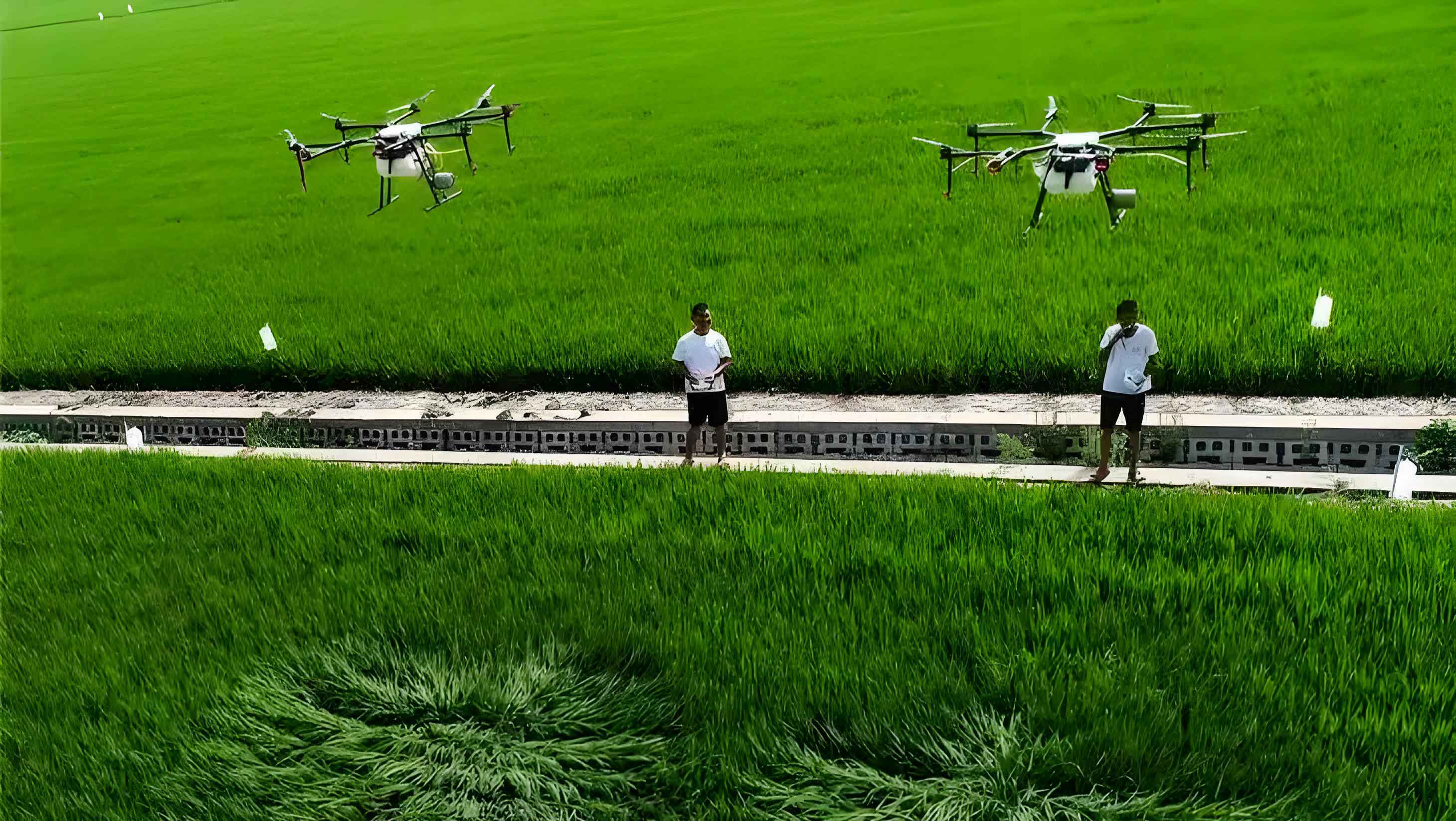
Agricultural UAV, commonly known as crop-dusting or spray drones, are remotely piloted or autonomous aerial systems specifically engineered for agricultural applications. Their core function is the precise, site-specific application of agrochemicals (herbicides, pesticides, rodenticide bait pellets) or biological agents. The modern agricultural UAV is more than just a flying sprayer; it is an integrated data-actuation platform often equipped with multispectral or RGB cameras for remote sensing, sophisticated flight planning software, and precise navigation systems (typically RTK-GPS).
4.1 Classification and Operational Characteristics
Agricultural UAV can be categorized by their propulsion and airframe design, each with distinct advantages for grassland applications:
| UAV Type | Propulsion | Typical Payload | Endurance | Key Advantages for Grasslands | Considerations |
|---|---|---|---|---|---|
| Electric Multi-Rotor | Battery-powered electric motors (4, 6, 8+ rotors) | 10-40 kg (Liquid) / 25-50 kg (Granular) | 10-25 minutes per battery | Vertical Take-off and Landing (VTOL), exceptional maneuverability, ability to hover, low operational footprint. Ideal for small, irregular, or obstructed plots. | Frequent battery swaps required; lower single-sortie coverage compared to fixed-wing. |
| Electric Fixed-Wing | Battery-powered electric motor with propeller | 5-15 kg | 45-90 minutes | High aerodynamic efficiency, long endurance, high speed, excellent for large, contiguous areas. | Requires runway or launcher for take-off; less agile; more complex recovery (e.g., parachute, belly landing). |
| Hybrid VTOL | Electric (for rotors) + Gasoline (for cruise) or all-electric with tilt-rotor mechanisms | 20-100 kg | 1-4 hours | Combines VTOL convenience with fixed-wing endurance and speed. Ultimate flexibility for mixed-terrain large-scale operations. | Higher cost, greater mechanical complexity. |
For the vast majority of grassland pest control scenarios, especially in topographically complex regions, multi-rotor agricultural UAV have become the tool of choice due to their unmatched operational flexibility, ease of deployment, and rapidly declining costs.
4.2 The Application Process: From Scouting to Spraying
Effective use of an agricultural UAV follows a systematic workflow:
- Mission Planning & Zoning: Using satellite imagery or pre-flight scouting data, the target area is mapped in flight planning software (e.g., DJI Terra, Pix4Dfields). Zones of high pest pressure, identified through remote sensing indices (e.g., NDVI anomalies for plant stress) or ground truthing, can be designated for focused treatment, while unaffected areas are excluded. This is the foundation of precision agriculture.
- Payload Configuration: The appropriate agent is selected and loaded. For insects and toxic plants, this is typically a liquid tank with nozzles producing ultra-low volume (ULV) droplets (80-150 microns). For rodents, specialized spreading systems disperse coated bait pellets.
- Autonomous Operation: The UAV follows the pre-programmed flight path autonomously, maintaining a constant altitude (typically 2-4 meters above vegetation) and speed. Advanced systems use LiDAR or ultrasonic sensors for terrain following. The spray is activated and deactivated automatically for each polygon, ensuring no overlap or missed spots.
- Data Logging & Analysis: The flight path, application rate, and operational parameters are logged. This data can be integrated with scouting maps to validate treatment efficacy and build a historical record for the management unit.
The application rate (AR, L/ha) is a critical parameter determined by the spray swath width (W), flight speed (V), and flow rate from the nozzles (Q):
$$AR = \frac{Q \cdot 600}{W \cdot V}$$
where $Q$ is in L/min, $W$ is in meters, $V$ is in km/h, and the constant 600 converts units to yield L/ha. Modern agricultural UAV control systems automatically adjust $Q$ as $V$ changes to maintain a constant $AR$.
5. Quantitative Advantages of UAV-Based Control in Grassland Ecosystems
The superiority of agricultural UAV technology over traditional methods can be quantified across several key performance indicators (KPIs).
5.1 Operational Efficiency and Coverage
The most striking advantage is in work capacity. A single multi-rotor agricultural UAV operated by a pilot and a support crew for mixing/loading can consistently cover 50-80 hectares per day under typical conditions. In contrast, a team of 10 personnel using backpack sprayers may cover only 4-6 hectares per day. This represents an efficiency increase of one to two orders of magnitude. The coverage rate $C_{UAV}$ (ha/hr) is a function of payload capacity $P$ (L), application rate $AR$ (L/ha), and cycle time $T_c$ (hr, including flight, reload, and battery swap):
$$C_{UAV} = \frac{P}{AR \cdot T_c}$$
For example, a UAV with $P = 20$ L, applying at $AR = 5$ L/ha, with a $T_c = 0.2$ hr (12-minute cycle), achieves $C_{UAV} = 20$ ha/hr.
5.2 Chemical Utilization and Environmental Impact
Agricultural UAV employ ULV spraying technology, which drastically reduces the volume of water used as a carrier—often by 80-90% compared to high-volume ground sprayers. More importantly, the downwash airflow generated by the rotors (Rotor-Induced Airflow) is a critical differentiator. This turbulent airflow penetrates the crop canopy, enveloping stems and the undersides of leaves, dramatically increasing droplet deposition efficiency and uniformity. This allows for effective pest control with a reduction in the active ingredient concentration, typically by 20-30%, while achieving equal or superior efficacy. This minimizes chemical runoff and soil residual, aligning with environmental stewardship goals.
5.3 Economic Analysis and Cost-Benefit
While the initial capital investment in an agricultural UAV system is significant, the total cost of operation per hectare ($\text{COP}_{ha}$) becomes highly competitive at scale. $\text{COP}_{ha}$ includes fixed costs (depreciation, insurance) and variable costs (labor, chemicals, energy, maintenance).
$$\text{COP}_{ha} = \frac{C_{fixed}}{A_{annual}} + C_{variable}$$
where $C_{fixed}$ is annual fixed cost, $A_{annual}$ is annual area treated, and $C_{variable}$ is variable cost per hectare. Due to the high $A_{annual}$, the fixed cost per hectare becomes very low. A simplified comparative analysis is shown below:
| Cost Component | Manual Backpack Spraying (per hectare) | Agricultural UAV Operation (per hectare) |
|---|---|---|
| Labor | Very High (15-20 person-hours) | Very Low (0.1-0.2 person-hours) |
| Chemical | Base Cost (100%) | 70-80% of Base Cost |
| Water & Carrier | Significant | Negligible |
| Equipment Depreciation & Fuel | Low | Moderate |
| Total Operational Cost | X (Reference) | ~0.3X – 0.5X |
The economic benefit is further amplified by the prevention of yield loss. Timely control enabled by the speed of UAVs protects a greater proportion of the forage biomass, directly translating to higher livestock carrying capacity or reduced need for supplemental feed.
5.4 Safety and Accessibility
Agricultural UAV eliminate the need for operators to traverse hazardous terrain or come into direct contact with chemicals. The risk of operator poisoning, injury from rough terrain, or encounters with wildlife is virtually eliminated. This is a paramount ethical and practical advantage. Furthermore, UAVs can easily treat areas that are completely inaccessible to ground equipment, such as steep slopes, wetlands, or areas with dense shrubbery, ensuring comprehensive pest management.
6. Integrated Case Study: UAVs in a Degraded Temperate Steppe Ecosystem
Consider a hypothetical but representative management unit within a temperate steppe ecosystem experiencing concurrent pressures from grasshoppers, zokors, and invasion of Stellera chamaejasme. The integrated application of agricultural UAV technology would proceed as follows:
Phase 1: Diagnostic Remote Sensing. A fixed-wing mapping UAV or satellite data is used to generate high-resolution NDVI and other spectral indices maps. Low-NDVI patches may indicate insect damage or toxic plant infestation. Burrow mound densities can be identified via very high-resolution RGB imagery. This map delineates three distinct management zones: a rodent-heavy zone, an insect-toxic plant mixed zone, and a healthy zone.
Phase 2: Targeted, Sequential Intervention.
Early Season (Rodent Control): A multi-rotor agricultural UAV equipped with a granular spreader flies over the rodent zone at a height of 10m, dispersing biodegradable bait pellets containing a rodenticide like bromadiolone or more environmentally sensitive agents like botulinum toxin (C, D type). The precision of GPS-guided spreading ensures bait is placed effectively while minimizing waste and non-target exposure.
Mid-Season (Insect Control): During the 3rd-4th instar nymph stage of grasshoppers (the optimal control window), the same UAV, now with a liquid spray system, executes a mission over the insect-impacted areas. It applies a ULV formulation of a biological insecticide like Metarhizium anisopliae fungus or a reduced-risk chemical like spinosad. The rotor downwash ensures the spray penetrates to the base of grasses where nymphs reside.
Late Season (Toxic Plant Control): During the flowering stage of Stellera (when it is most vulnerable and visible), the UAV performs a spot-application mission. Using its high-accuracy RTK positioning, it applies a selective herbicide (e.g., aminopyralid) only to the GPS-tagged infestation polygons, minimizing herbicide use by over 95% compared to broadcast spraying.
Phase 3: Efficacy Monitoring and Adaptive Management. Post-treatment, follow-up remote sensing flights quantify changes in NDVI and infestation coverage. The results are fed back into the management plan for the subsequent year, creating a closed-loop, adaptive system. This integrated, data-driven approach, powered by agricultural UAV, achieves higher efficacy, lower cost, and significantly reduced ecological footprint than any sequential application of traditional methods.
7. Future Trajectories and Integration with Smart Agriculture
The evolution of agricultural UAV for grassland management is moving rapidly towards greater autonomy, intelligence, and integration. Key future trends include:
- Swarm Intelligence: Coordinated fleets of multiple agricultural UAV operating simultaneously, managed by a single ground station, to exponentially increase treatment capacity for large-scale outbreak response.
- AI-Powered Real-Time Decision Making: Onboard processing units using machine vision to identify individual pest species or weed plants in real-time during flight, triggering instantaneous, targeted micro-sprays. This moves from “zoned” to “plant-by-plant” precision.
- Advanced Payloads: Development of UAV-compatible formulations for beneficial biological agents (predatory insects, nematodes), soil amendments, or grass seeds for reseeding degraded patches in a single pass.
- Seamless Data Fusion: Tighter integration with IoT soil sensors, weather stations, and satellite constellations to create a digital twin of the grassland ecosystem. The agricultural UAV becomes the primary physical actuator within this cyber-physical system, executing management prescriptions generated by predictive ecological models.
In conclusion, the challenges facing the world’s grasslands are immense and growing. The advent of agricultural UAV technology provides a powerful, scalable, and precise toolset to address the tripartite threat of insects, rodents, and toxic plants. By dramatically improving operational efficiency, economic viability, environmental safety, and treatment efficacy, agricultural UAV are not merely an incremental improvement but a foundational technology for the future of sustainable grassland ecosystem management. Their integration into holistic, data-driven stewardship programs represents the most promising pathway to preserving these vital ecosystems for generations to come.