In recent years, the advent of unmanned aerial vehicles (UAVs) has significantly accelerated the intelligent development of surveying and mapping equipment. Traditional surveying methods are gradually transitioning to new surveying technologies, and their application fields continue to expand, finding excellent use in power line inspection, forest fire prevention, historical documentation, and 3D city modeling. The outcomes of UAV aerial surveying have also diversified, enabling the generation of high-resolution, high-precision true digital orthophoto maps (TDOM), the construction of digital elevation models (DEM) within the survey area, and the establishment of sparse point clouds, laying the data foundation for the expanded application of UAV aerial surveying. Faced with surveying tasks in complex terrains, manual data collection using traditional surveying instruments is often time-consuming and labor-intensive, and there are situations where personnel cannot access the survey area. In such cases, aerial support from UAVs becomes particularly crucial.
With the continuous advancement of urban high-quality development, the original road functions in cities can no longer meet the growing demand for transportation. The rapid reconstruction of main roads is urgent, and urban expressways have become the backbone of the urban road network. The increasing number of urban expressways poses new and higher requirements for the rapid updating and surveying of reconstruction areas. The application of UAV aerial surveying technology can not only quickly acquire image data of expressways but also provide strong technical support for the updating of topographic maps. This study is based on the surveying and mapping project of the Zhanqian Expressway in Taizhou, explaining the application of UAV aerial surveying in updating topographic maps for urban expressways.
Urban expressways often adopt elevated designs, characterized by significant height differences from ordinary roads, long lengths forming带状 (belt-shaped) areas, and fast traffic speeds. Manual data collection is slow, time-consuming, and has low safety factors. Traditional surveying methods struggle to quickly obtain topographic data of expressways and cannot intuitively display the unique features and roles of expressways in urban areas. UAV aerial surveying can effectively solve these problems. However, general UAV aerial surveying systems often suffer from severe image distortion and must rely on a large number of ground control points to improve image positional accuracy. It is challenging to arrange control points along expressways and their surroundings according to requirements. Currently, aerial surveying UAVs can be divided into fixed-wing, multirotor, and hybrid-wing UAVs based on the flight platform. Among them, fixed-wing and hybrid-wing UAVs have strict requirements for takeoff and landing points, making it difficult to find suitable sites in densely built urban areas. In contrast, multirotor drones use vertical takeoff and landing, are almost不受 (unconstrained) by site limitations, and make aerial surveying implementation more convenient.
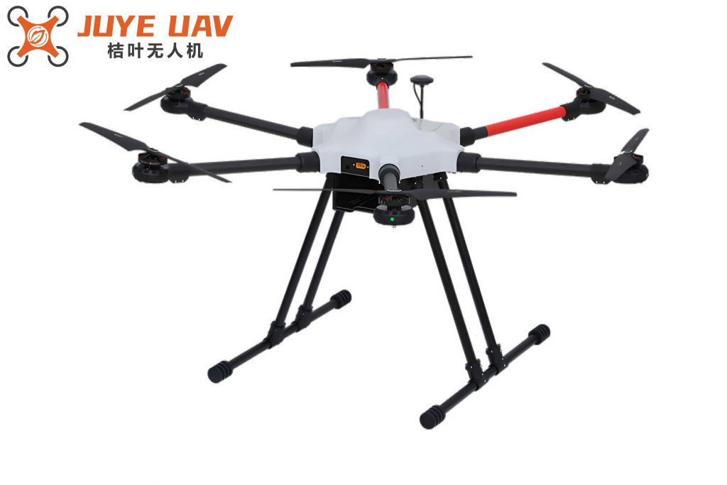
The FeiMa D200S UAV aerial surveying system employs a multirotor flight platform. Through ground-air real-time fusion differential positioning, it no longer requires the arrangement of control points while ensuring that the accuracy of aerial surveying results meets the requirements of surveying specifications. This significantly improves aerial surveying efficiency, and the images are clear, the results diverse, and the applications wide-ranging. This multirotor drone system represents a significant advancement in the field.
Overview of the FeiMa D200S Multirotor Drone Aerial Surveying System
The FeiMa D200S intelligent aerial surveying system is a UAV aerial surveying system based on a high-performance multirotor platform. Its main advantages are high mapping accuracy and simple operation methods. The flight platform adopts a multi-path redundant sensor design, ensuring safety and reliability and guaranteeing high-quality aerial operations. This multirotor drone system is highly compatible and integrated, capable of carrying single-camera vertical, five-camera oblique aerial photography, LiDAR, and video payloads, enabling efficient data acquisition and diverse results. The built-in high-precision differential GNSS board can select PPK, RTK, and their fusion operation modes, supporting POS-assisted aerial triangulation to achieve high-precision mapping without control points. The flight control system has precise terrain-following flight capabilities, ensuring consistency in the acquired image resolution or LiDAR point cloud density.
The flight platform of the FeiMa D200S aerial surveying system is a four-axis, four-rotor FeiMa drone with a takeoff weight of 7.5 kg and a standard payload weight of 1 kg. It uses a vertical takeoff and landing method without a runway, has strong wind resistance, and can operate normally in wind forces up to level 5. The equipped camera payload is a single-lens, two-axis stabilized gimbal camera, the SONY RX1R II full-frame camera, with a 35mm fixed focal length lens, a sensor size of 39.5 mm × 24 mm, and 42 million (7952 × 5304) effective pixels. The high-performance camera is the hardware foundation for acquiring high-definition images.
The aerial surveying RTK system consists of a ground GNSS base station, an onboard GNSS receiver, a differential data processing system, and a data transmitter. The built-in high-precision differential GNSS board can receive GPS L1+L2, BeiDou B1+B2, GLONASS L1+L2 satellite signals, with a sampling frequency of 20 Hz and a positioning accuracy of 2 cm. Using PPK/RTK and their fusion operation modes, the RTK horizontal accuracy in hover state is 1 cm + 1×10⁻⁶, and the vertical accuracy is 2 cm + 1×10⁻⁶. The fusion differential operation mode improves the positional accuracy of each aerial photo, providing strong support for the control-free mode of the aerial surveying system.
The flight control system and orthophoto post-processing of the FeiMa D200S are completed in one stop in the “UAV Manager Professional” software. The FeiMa UAV Manager manages the entire workflow of UAV aerial photography and data post-processing, including precise 3D route planning, 3D real-time flight monitoring, control point measurement to aerial triangulation processing, and automatic generation of various data results such as DOM, DEM, DSM, TDOM, 2.5D models, true 3D models, and standard LiDAR point clouds, with 3D browsing capabilities. The manager supports information push, project synchronization, flight data sharing, active aircraft maintenance, flight record analysis, and display functions, enabling unified planning and allocation of aerial photography tasks, centralized assignment by one person, and multi-person, multi-end collaborative operations; real-time tracking of task progress, timely mastery of collaborative operation status. The high integration of the FeiMa UAV Manager makes aerial surveying simple to operate and convenient to implement.
Aerial Surveying Implementation Process
The Zhanqian Expressway in Taizhou has an east-west length of approximately 11 km and a width of 50 m. The areas along the road mainly include factories, residential buildings, and other structures. The vegetation is primarily farmland, reeds, and landscape trees. The route passes through main rivers, crosses provincial roads and urban main roads. The expressway is mainly elevated, with a large height difference from ordinary road surfaces, and the traffic flow on the road is fast. Traditional surveying methods are difficult to implement and have low safety factors. Therefore, the FeiMa D200S multirotor drone aerial surveying system was applied to quickly obtain the required surveying field data and automatically generate various results. The aerial surveying workflow is shown in Figure 1.
The selection of UAV takeoff and landing points, i.e., field operation points, needs to be finalized after repeated surveys of the surrounding environment. First, adhere to the principle of safety first. It must be ensured that the D200S rotorcraft is placed on flat ground with a radius of at least 5 m. The surrounding environment should be as open as possible, maintaining a safe distance from high-voltage lines, signal towers, dense buildings, etc., and away from crowded places. During the UAV takeoff and landing process, special personnel should observe the surrounding environment to prevent safety accidents.
The surveying area of the Zhanqian Expressway is带状 (belt-shaped). Based on this and considering the performance of the FeiMa D200S multirotor drone, the survey area was divided into five photography areas. Each photography area is approximately 2 km long from east to west and 1 km wide from north to south. Although the width of the Zhanqian Expressway is only about 50 m, to ensure the stitching quality of aerial photos and mapping accuracy, the length-to-width ratio of the photography area must be reduced. Considering the terrain update range and aerial surveying efficiency, each sub-photography area was completed using断点续航 (breakpoint continuation) aerial photography. The flight height was set at 233 m, the ground resolution was 4 cm, the along-track overlap was set to 80%, and the cross-track overlap was set to 70%.
The flight data for each photography area must be manually preliminarily checked. The acquired POS data is displayed in plane point form in GlobalMapper software to check for any missing POS data points. If missing points are found, the corresponding aerial photos are located according to the sequence of missing points and deleted. This ensures no errors when importing POS data and corresponding photos into the system. Using the 3D browsing function of GlobalMapper software to display POS data allows intuitive judgment of whether the flight height corresponding to each POS point has a significant height difference. The difference between the flight height corresponding to the photo and the preset flight height should not exceed the specified range. Excessive flight height differences can affect photo stitching results, causing distortion and blurring in the resulting images and reducing positional accuracy here. Usually, large flight height differences do not occur. If a large number of POS points have large flight height differences, re-flight is necessary.
After initial inspection of the aerial surveying data, the intelligent mapping module in the FeiMa UAV Manager software is used for differential GPS solution processing to obtain high-precision POS data. The POS data and corresponding photos are imported into the intelligent stitching module, relevant parameters are set, and with one click, control-free automatic generation of sparse point cloud data, DEM, and TDOM data results is achieved. The entire process requires no manual intervention. In the 3D mapping software EPS, the DEM is processed to generate a vertical image model. Importing the TDOM allows obtaining coordinate data and elevation values of various topographic elements on the image for topographic map drawing, achieving naked-eye mapping. The conversion from image maps to digital line graphs can be completed without field data collection.
Quality Inspection and Analysis of Aerial Surveying Results
Before the flight implementation, accuracy check points were set up within the survey area of the Zhanqian Expressway. When setting up, full use was made of existing ground points with obvious features, such as the corner points of pedestrian crossings, road turning points, and brick corners. If there were no obvious feature points on the ground, markers were sprayed with paint or fixed control markers were placed in the survey area. RTK was used to promptly measure the plane coordinates and elevation of the check points to obtain measured values. In the EPS 3D mapping software, the image acquisition values corresponding to the check points were directly obtained. The comparison calculation results of 30 collected check points are statistically shown in Table 1.
| Point Name | Measured X (m) | Measured Y (m) | Measured H (m) | Image X (m) | Image Y (m) | Image H (m) | Planar Difference (m) | Elevation Difference (m) |
|---|---|---|---|---|---|---|---|---|
| JK1 | 488737.760 | 3600030.198 | 3.648 | 488737.810 | 3600030.228 | 3.778 | 0.06 | 0.13 |
| JK2 | 488717.030 | 3600113.073 | 3.987 | 488717.140 | 3600113.053 | 3.777 | 0.11 | -0.21 |
| JK3 | 489007.638 | 3600001.877 | 3.155 | 489007.678 | 3600001.827 | 3.305 | 0.06 | 0.15 |
| JK30 | 493302.366 | 3600197.461 | 3.970 | 493302.406 | 3600197.431 | 4.150 | 0.05 | 0.18 |
The verification results show that the maximum planar difference is 0.18 m, the minimum planar difference is 0.02 m, the maximum elevation difference is 0.27 m, and the minimum elevation difference is 0.08 m. The planar root mean square error (RMSE) is ±0.09 m, and the elevation RMSE is ±0.17 m. Its accuracy meets the requirements for 1:1000 scale topographic mapping. Based on this image, topographic map drawing can be completed, greatly reducing the field workload for expressway topographic mapping and improving the production efficiency of带状 (belt-shaped) topographic maps. The resulting images from the FeiMa D200S aerial survey are continuously complete, clear and easy to read, with moderate contrast and uniform色调 (tone), which is also a prerequisite for the aerial survey accuracy to meet specification requirements.
The formulas used for calculating the root mean square errors are as follows. The planar RMSE, denoted as \( m_p \), is calculated using the formula:
$$ m_p = \sqrt{\frac{\sum_{i=1}^{n} (\Delta X_i^2 + \Delta Y_i^2)}{n}} $$
where \( \Delta X_i \) and \( \Delta Y_i \) are the differences in the X and Y coordinates for the i-th check point, and n is the number of check points.
The elevation RMSE, denoted as \( m_h \), is calculated using the formula:
$$ m_h = \sqrt{\frac{\sum_{i=1}^{n} \Delta H_i^2}{n}} $$
where \( \Delta H_i \) is the difference in the H (elevation) coordinate for the i-th check point.
For the ground sample distance (GSD), which determines the resolution of the imagery, the formula is:
$$ GSD = \frac{H \times s}{f} $$
where H is the flight height, s is the sensor size (e.g., pixel size), and f is the focal length of the camera. In our case, with a flight height of 233 m, a sensor width of 39.5 mm, and a focal length of 35 mm, the GSD can be verified to be approximately 4 cm, ensuring high-resolution data acquisition for the multirotor drone survey.
Conclusion
The successful application of the multirotor drone control-free aerial surveying system, combined with 3D mapping software, has become a new and more efficient surveying method for urban expressways, providing various basic data for urban construction development. Based on the FeiMa D200S multirotor drone aerial surveying system, this study investigated its application in the topographic mapping of the Taizhou Zhanqian Expressway. Practice has shown that the multirotor drone control-free aerial surveying system is simple and easy to use, safe and reliable, and the results comply with relevant surveying specifications and technical requirements. In areas with complex topography, it发挥了 (gave full play to) its unique advantages, solving many problems that are difficult to implement manually. The multirotor drone aerial surveying system will play an increasingly important role in surveying complex terrain areas, the construction of real 3D China, and smart city construction.
The use of multirotor drones, such as the FeiMa D200S, offers significant advantages in terms of operational flexibility, data accuracy, and efficiency. The ability to perform vertical takeoff and landing eliminates the need for runways, making it ideal for urban environments where space is limited. The integration of high-precision GNSS technology ensures that accurate positional data is acquired without the need for numerous ground control points, streamlining the surveying process. Furthermore, the diverse outputs—including point clouds, DEMs, and TDOMs—provide comprehensive datasets that support various applications, from engineering design to environmental monitoring.
In future work, we plan to explore the integration of additional sensors, such as thermal cameras or multispectral imagers, with the multirotor drone platform to expand its applicability to other domains like infrastructure inspection and agricultural monitoring. The continuous improvement in UAV technology, coupled with advanced data processing algorithms, will further enhance the capabilities of multirotor drones in topographic mapping and beyond. The multirotor drone is poised to become an indispensable tool in the geospatial industry, driving innovation and efficiency in data acquisition and analysis.