
As a practitioner deeply engaged in the field of emergency response and technological application, I have witnessed a paradigm shift in how we approach the formidable challenge of forest fires. Forests are indispensable regulators of our natural environment, providing critical ecosystem services from water purification and climate regulation to harboring immense biodiversity. Economically, forestry constitutes a vital sector. However, the devastating impact of uncontrolled wildfires—characterized by sudden onset, rapid spread, and extreme difficulty in containment—poses a persistent threat to these resources and human safety. Traditional methods of fire monitoring, relying on ground patrols, watchtowers, and manned aircraft, are often inadequate: they are resource-intensive, expose personnel to significant risk, and lack the real-time, comprehensive situational awareness needed for effective response.
In this context, Unmanned Aerial Vehicles (UAVs), or drones, have emerged as a transformative technology. Their mobility, operational range, and ability to remove human operators from direct danger present a potent solution. Specifically, fire UAV systems equipped with advanced vision-based sensors and intelligent algorithms offer unprecedented capabilities in persistent surveillance, early detection, accurate diagnosis, and even direct suppression. This article systematically explores the development, technical architecture, key enabling technologies, and practical deployment challenges of fire UAV systems for forest fire management, reflecting on the current state and future trajectory from a first-person perspective of applied research and operational integration.
1. System Overview and Architecture of Fire UAV Operations
The operational paradigm for a fire UAV system in forest fire scenarios is built upon a cohesive integration of aerial platforms, sensor payloads, communication links, and ground control intelligence. The core mission sequence can be formally decomposed into three phases: Search, Confirmation, and Observation/Suppression.
Let $M$ represent the entire mission, which is a function of time $t$, UAV agent states $S_i(t)$, and environmental data $E(t)$. The phased mission logic is as follows:
$$ M(t) = \begin{cases}
\text{Phase 1: Search} & \text{if } I_{fire}(t) = 0 \\
\text{Phase 2: Confirmation} & \text{if } I_{fire}(t) = 1 \text{ and } C_{confirm}(t) = 0 \\
\text{Phase 3: Observation} & \text{if } I_{fire}(t) = 1 \text{ and } C_{confirm}(t) = 1
\end{cases} $$
where $I_{fire}(t)$ is a binary indicator function for initial fire detection, and $C_{confirm}(t)$ is a confirmation check.
The architecture enabling this mission logic is multi-layered. A typical fire UAV system consists of the following interconnected components:
- Aerial Platform: The UAV itself, characterized by its airframe (fixed-wing for long-endurance patrol, multi-rotor for hovering and precise observation), propulsion system (electric or gasoline), and flight control system (autopilot, GPS, IMU).
- Sensor Payload: The suite of detectors carried by the fire UAV. This is the core of its reconnaissance capability.
- Visual Spectrum (RGB) Cameras: Provide high-resolution daytime imagery for visual confirmation and mapping.
- Thermal Infrared (IR) Cameras: Detect heat signatures, enabling 24/7 operation, seeing through smoke, and identifying hot spots. The radiance $L_{detected}$ measured by an IR sensor can be related to the temperature $T_{target}$ of a fire pixel via Planck’s Law approximation: $$ L_{detected} = \frac{\epsilon C_1}{\lambda^5 (e^{\frac{C_2}{\lambda T_{target}}} – 1)} $$ where $\epsilon$ is emissivity, $\lambda$ is wavelength, and $C_1$, $C_2$ are constants.
- Multi-spectral/Hyperspectral Sensors: Identify specific chemical signatures of combustion (e.g., CO2, CO).
- LiDAR: For creating detailed 3D terrain models to assess fire spread dynamics.
- Communication Data Link: A robust, long-range link for transmitting command & control signals uplink and sensor data/telemetry downlink in real-time.
- Ground Control Station (GCS): The human-machine interface. Operators plan missions, monitor UAV status, and analyze incoming data. The GCS hosts the software for fire detection algorithms, data fusion, and visualization.
- Data Processing & Analysis Module: Often edge-computed on the UAV or processed at the GCS, this module runs algorithms for real-time fire pixel identification, geo-referencing, and spread prediction.
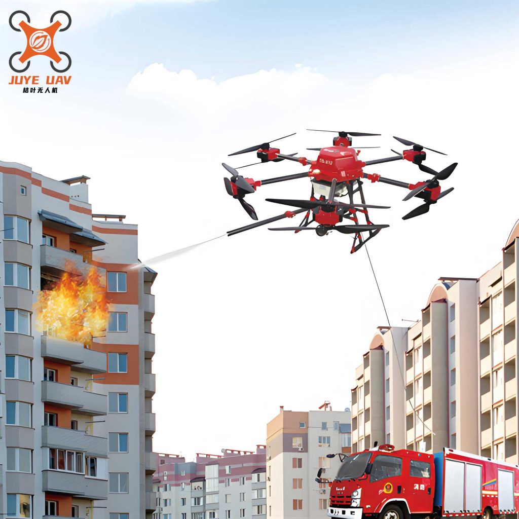
The image above illustrates a modern fire UAV platform, showcasing a robust multi-rotor design capable of carrying essential payloads like thermal cameras and, potentially, suppression equipment. This visual aligns perfectly with the architectural concept of a versatile, sensor-laden aerial robot for fire service.
| System Component | Primary Function | Technical Specifications/Examples |
|---|---|---|
| Aerial Platform | Carries payload, executes flight path | Endurance (e.g., >60 min), Payload Capacity (e.g., >2 kg), Wind Resistance (e.g., >6级/Beaufort 7), Operational Ceiling (e.g., 300-1000 m AGL) |
| Sensor Payload | Data acquisition (Visual, Thermal, Spectral) | RGB Camera (e.g., 4K), IR Camera (e.g., 640×512 px, 30 Hz), Gimbal Stabilization |
| Communication Link | Real-time data/command transmission | Range (e.g., >10 km), Bandwidth, Latency, Redundancy (e.g., dual-link) |
| Ground Control Station | Mission planning, monitoring, data analysis hub | Software for GIS integration, real-time video analytics, fleet management |
| Processing Module | Onboard/ground-based data analysis | Fire detection algorithms (AI/ML), image stabilization, 3D mapping software |
2. In-Depth Exploration of Core Technologies
2.1 Fire Detection and Recognition Algorithms
The “eyes” of the fire UAV are its sensors, but its “brain” is the detection algorithm. Early methods relied on thresholding in color (RGB) or temperature (IR) spaces. A simple IR threshold model can be: $$ P_{fire}(x,y) = \begin{cases} 1 & \text{if } T_{pixel}(x,y) > T_{threshold} \\ 0 & \text{otherwise} \end{cases} $$ where $P_{fire}$ is the fire pixel label. However, this is prone to false positives from sun-heated objects.
Modern approaches leverage machine learning and computer vision. Convolutional Neural Networks (CNNs) are trained on vast datasets of fire and non-fire imagery. A CNN model $f_{CNN}$ takes an image patch $I$ as input and outputs a probability $p$ of fire presence: $$ p = f_{CNN}(I; \theta) $$ where $\theta$ represents the learned weights of the network. These models can learn complex features like flame texture, flicker frequency, and smoke patterns, significantly improving accuracy. Multi-modal fusion, combining RGB and IR data within the network, further enhances reliability under diverse conditions (day/night, smoky/clear).
2.2 Fire Diagnostics, Prognostics, and Spread Modeling
Once a fire is confirmed, the fire UAV transitions to a diagnostic and prognostic role. Diagnostics involve geo-locating the fire perimeter and measuring its intensity. Using photogrammetry or LiDAR data from the fire UAV, a 3D model of the terrain and fire front can be constructed. Fire intensity $I$ can be related to the rate of heat release per unit length of fire front, often inferred from flame height $H_f$ and IR readings.
Prognostics, or fire spread prediction, is critical. It often uses cellular automata or physics-based models like the Rothermel model, which calculates the rate of spread $R$ as: $$ R = \frac{I_R \xi (1 + \phi_W + \phi_S)}{\rho_b \epsilon Q_{ig}} $$ where $I_R$ is reaction intensity, $\xi$ is propagating flux ratio, $\phi_W$ and $\phi_S$ are wind and slope factors, $\rho_b$ is fuel bulk density, $\epsilon$ is effective heating number, and $Q_{ig}$ is heat of preignition. The fire UAV provides real-time input parameters for such models (wind at fire front, fuel moisture inferred from spectral data, terrain slope), enabling dynamic, data-driven predictions that guide ground crew deployment and evacuation planning.
2.3 Image Stabilization and Vibration Elimination
A persistent challenge for fire UAV operations in turbulent fire environments is image jitter. High winds and thermal updrafts cause vibrations that blur imagery and degrade detection performance. Stabilization occurs at two levels:
1. Mechanical: Using high-performance gimbals that actively counteract UAV movement.
2. Computational: Using video processing algorithms like Kalman filtering or feature-based registration to stabilize the image sequence post-capture. A simple digital stabilization aims to find a transformation $T_t$ for frame at time $t$ to align it with a reference frame, minimizing a cost function: $$ \min_{T_t} \sum_{x,y} | I_{ref}(x,y) – I_t(T_t(x,y)) |^2 $$ Clear, stable video is non-negotiable for accurate remote assessment by incident commanders.
2.4 Multi-UAV Collaborative Control and Swarm Intelligence
For large-scale fires, a single fire UAV is insufficient. The future lies in coordinated fleets. Multi-UAV systems can perform area coverage optimization for search, establish communication relays in mountainous terrain, or simultaneously monitor multiple flanks of a fire. Control strategies often involve decentralized algorithms. For perimeter monitoring, UAVs can be modeled as agents $i$ with dynamics $\dot{s}_i = u_i$, controlled to maintain a formation around the fire front. A potential field-based control law might be: $$ u_i = -\nabla_{s_i} \left( \sum_{j \neq i} V_{rep}(||s_i – s_j||) + V_{att}(s_i, \text{perimeter}) \right) $$ where $V_{rep}$ is a repulsive potential from other UAVs (collision avoidance) and $V_{att}$ is an attractive potential to the target perimeter. This enables autonomous, collaborative behavior, making the fire UAV swarm a resilient and scalable sensing network.
| Technology Category | Traditional/Simple Method | Advanced/Modern Method | Advantage of Advanced Method |
|---|---|---|---|
| Fire Detection | Thresholding (Color/Temp) | Deep Learning (CNN) & Multi-modal Fusion | Higher accuracy, lower false alarm rate, adapts to complex scenes |
| Spread Modeling | Static, fuel-map based models | Dynamic data-assimilation models (e.g., Rothermel with UAV inputs) | Real-time, location-specific predictions improve tactical decision-making |
| Image Stabilization | Passive dampers, basic EIS | High-torque gimbals + Advanced computer vision algorithms (Kalman filters) | Provides crystal-clear, actionable video in high-turbulence fire environments |
| Fleet Control | Single UAV, manual control | Decentralized multi-agent systems, swarm intelligence | Faster area coverage, system redundancy, enables complex multi-role missions |
3. Practical Deployment, Performance Metrics, and Operational Challenges
Translating the technological potential of the fire UAV into reliable field operations requires rigorous performance standards and honest assessment of hurdles. From an operational standpoint, the fire UAV must be treated as a mission-critical tool with defined capabilities.
| Performance Dimension | Minimum Operational Requirement (Example) | Rationale / Connection to Fireground Reality |
|---|---|---|
| Endurance & Range | > 45-60 minutes flight time; > 10 km control range | Must allow for transit to remote fire zones and sufficient loiter time for effective observation, minimizing launch/recovery cycles. |
| Wind Resistance | Operational in winds ≥ 6级/Beaufort 7 (13-17 m/s) | Fire fronts generate their own intense, erratic wind fields. The platform must remain stable and controllable. |
| Environmental Hardening | Dust/water resistance (IP54+); Operational temp range: -10°C to 50°C | Must withstand ash, smoke, rain, and extreme temperatures near the fire for reliable service. |
| Sensor Payload Quality | Radiometric thermal camera (e.g., 640×512); 4K visual with optical zoom | Need to distinguish hotspots from background (radiometry) and identify details (visual clarity) for accurate diagnostics. |
| Data Link Latency & Reliability | Latency < 200 ms; Redundant link (e.g., 4G/5G backup) | Real-time decision-making for piloting and fire assessment cannot tolerate significant delay or dropout. |
| Deployment Time & Portability | System setup < 5 min; Total system weight < 50 kg | Rapid deployment from a command vehicle is essential during the critical initial attack phase. |
Despite the clear advantages, the integration of fire UAV technology faces several systemic challenges:
- Lack of Standardization: The absence of authoritative design and interoperability standards for public safety UAVs leads to fragmented ecosystems. Data formats, communication protocols, and control interfaces are often proprietary, hindering the seamless integration of fire UAV systems from different manufacturers into a unified command-and-control framework.
- Incomplete System-of-Systems Approach: Many current deployments focus on a single UAV type (often small multi-rotors). A holistic fire UAV fleet requires a mix of platforms: long-endurance fixed-wing for wide-area patrol, heavy-lift multi-rotors for suppression payloads or LiDAR, and small quadcopters for confined space inspection. Coordinating this mix and their data products remains a complex task.
- Technical Performance Gaps: While improving, limitations in battery energy density directly constrain endurance and payload capacity. AI detection algorithms, while powerful, can struggle with false positives in complex environments (e.g., sun glint on metal roofs) and require continuous retraining with diverse datasets. Processing the deluge of high-resolution imagery and sensor data in real-time to extract actionable intelligence is a persistent computational challenge.
- Regulatory and Airspace Integration: Operating fire UAV systems, especially in swarms or Beyond Visual Line of Sight (BVLOS), in congested emergency airspace shared with manned aircraft (helicopters, air tankers) requires robust, dynamic airspace management protocols (e.g., UTM – Unmanned Traffic Management) that are still under development in many regions.
- Workforce Training and Sustainment: Effective use of a fire UAV goes beyond piloting. It requires skilled personnel for mission planning, data analysis, maintenance, and interpreting outputs for incident command. Developing this expertise and establishing sustainable career paths and logistics chains for maintenance and repair are crucial for long-term success.
| Challenge Category | Specific Issues | Potential Solutions & Mitigation Pathways |
|---|---|---|
| Technical & Performance | Limited endurance, sensor false positives, data processing bottlenecks | Hybrid gasoline-electric propulsion; Federated learning for improved AI models; Edge computing on UAVs; Standardized data APIs. |
| Systemic & Operational | Lack of fleet diversity, interoperability, integrated C2 systems | Develop procurement standards for multi-role fleets; Adopt open architecture standards (e.g., STANAG 4586); Invest in unified mission software platforms. |
| Regulatory & Human Factors | Complex airspace coordination, lack of trained personnel | Pilot joint exercises with aviation units; Develop accredited training/certification programs for UAV technicians and data analysts; Implement UTM for emergency services. |
4. Future Outlook and Concluding Synthesis
The trajectory for fire UAV technology is one of increasing autonomy, intelligence, and integration. We are moving towards systems where a swarm of heterogeneous UAVs can autonomously patrol a forest district, detect an ignition with near-zero latency, track its perimeter in real-time, predict its propagation using onboard or cloud-based models, and even initiate first-response suppression by deploying retardant capsules or creating backfires—all while providing a persistent, multi-perspective data stream to incident commanders on the ground. The core enabling trends include:
- Advanced AI and Autonomy: Moving from detection to understanding—algorithms that can assess fire behavior, identify potential risks to infrastructure, and suggest optimal intervention points.
- Enhanced Communication Networks: Integration with satellite constellations (e.g., Starlink) and mobile ad-hoc networks (MANET) for reliable connectivity in remote areas, enabling true BVLOS operations for the fire UAV fleet.
- Swarm Intelligence: Development of robust algorithms for large-scale, decentralized UAV coordination, enabling self-organizing behaviors for optimal area coverage, communication relay chains, and distributed sensing.
- Direct Suppression Capabilities: Evolution of the fire UAV from a pure sensing platform to an active intervention tool, with specialized models capable of carrying and precisely delivering water, foam, or fire-retardant chemicals.
In conclusion, the fire UAV has irrevocably altered the landscape of forest fire management. It is not merely a new tool but the cornerstone of a new operational philosophy—one centered on data-driven awareness, proactive response, and the preservation of responder safety. The journey from technological novelty to a mature, standardized, and indispensable component of the wildfire fighting arsenal requires continued collaboration across disciplines: between roboticists and fire scientists, software developers and veteran firefighters, regulators and operators. By addressing the existing challenges in standardization, system integration, and training, we can fully unlock the potential of these aerial sentinels. The intelligent fire UAV system represents our most promising path forward to safeguard our vital forest ecosystems against the growing threat of catastrophic wildfires.