The integration of Unmanned Aerial Vehicle (UAV) technology into firefighting operations represents a paradigm shift in emergency response methodologies. Often referred to specifically as fire UAVs or firefighting drones, these systems have transitioned from experimental tools to critical assets on the front lines of disaster management. As a technology professional deeply engaged in this field, I have observed and analyzed the rapid maturation of these platforms. A fire UAV is fundamentally an aerial robot, governed by a combination of remote control, autonomous flight algorithms, and sophisticated sensor fusion, designed to execute missions too dangerous, costly, or inefficient for human responders. The core demand from the fire service is unambiguous: to acquire actionable intelligence, enhance operational safety, and improve mission efficacy across the disaster lifecycle—from initial reconnaissance and active suppression to post-incident damage assessment.
The operational canvas for a fire UAV is vast and varied. In the chaotic first moments of a fire, the primary need is for rapid situational awareness. During active firefighting, the requirement shifts to supporting suppression tactics and search-and-rescue (SAR) operations. Finally, in the aftermath, the focus moves to precise, large-scale damage documentation. The advantages offered by deploying a fire UAV are transformative. They enable a rapid response, often reaching the scene ahead of ground units to provide a critical overhead view. This leads to more efficient resource deployment, as commanders can direct crews based on real-time data. Most importantly, they enhance firefighter safety by acting as remote “eyes” in immediately dangerous to life or health (IDLH) environments. Furthermore, the cost-benefit ratio is compelling, as a single fire UAV system can perform tasks that would otherwise require helicopters, specialized crews, and significant time.
Current State of Fire UAV Applications
1. Fire Scene Reconnaissance and Intelligence Gathering
The initial and most prevalent application of a fire UAV is in aerial reconnaissance. Upon deployment, the drone provides an immediate tactical overview. Equipped with multi-sensor payloads, it delivers data far beyond visible light. A standard reconnaissance fire UAV payload typically includes:
| Sensor Type | Primary Function | Data Output | Key Metric |
|---|---|---|---|
| Visible Light (RGB) Camera | High-definition real-time video, photogrammetry | Geo-tagged photos/video, 3D maps | Resolution (e.g., 4K/30fps), Optical Zoom |
| Thermal Imaging Camera | Heat source detection, victim search through smoke | Thermographic video, temperature matrices | Resolution (e.g., 640×512), Thermal Sensitivity (< 50mK) |
| Multi-gas Sensor | Detection of toxic/combustible gases (CO, CH₄, VOCs) | Gas concentration levels (ppm/ppb) | Detection Range, Accuracy, Response Time |
| LiDAR (Light Detection and Ranging) | 3D mapping through smoke/foliage, structural integrity assessment | High-density point clouds | Points per second, Range Accuracy |
The intelligence derived is processed to answer critical questions: Where is the fire’s origin (seat)? What is the direction and rate of spread? Are there potential flashover or backdraft conditions? Are there visible trapped individuals? The thermal camera is particularly crucial, as it can see through smoke to identify hotspots, unseen fire spread within walls or attics, and human shapes based on body heat signature. The probability of successful target identification (e.g., a hotspot or victim) can be modeled as a function of sensor performance and environmental conditions:
$$ P_{identify} = 1 – e^{-\lambda (S/N) \cdot A_{target} \cdot t_{obs}} $$
where $\lambda$ is the sensor’s detection efficiency, $(S/N)$ is the signal-to-noise ratio degraded by atmospheric obscurants like smoke, $A_{target}$ is the effective area of the target, and $t_{obs}$ is the observation time. The fire UAV’s ability to loiter and observe from multiple angles directly increases $t_{obs}$, thereby boosting $P_{identify}$.
The operational superiority of a fire UAV for reconnaissance is clear when compared to traditional methods:
| Aspect | Traditional Recon (Ground Crew/Helicopter) | Fire UAV Recon |
|---|---|---|
| Deployment Time | Minutes to hours (crew mobilization, helicopter dispatch) | Seconds to minutes (immediate launch) |
| Perspective & Coverage | Limited, ground-level or costly aerial with limited loiter | High, flexible altitude and angle, persistent coverage |
| Personnel Risk | High (exposure to direct hazards) | Minimal (remote operation) |
| Data Latency | High (verbal reports, delayed video feeds) | Low (real-time HD/thermal streaming) |
| Operational Cost | Very High (fuel, crew, maintenance for aircraft) | Relatively Low (electric power, minimal crew) |
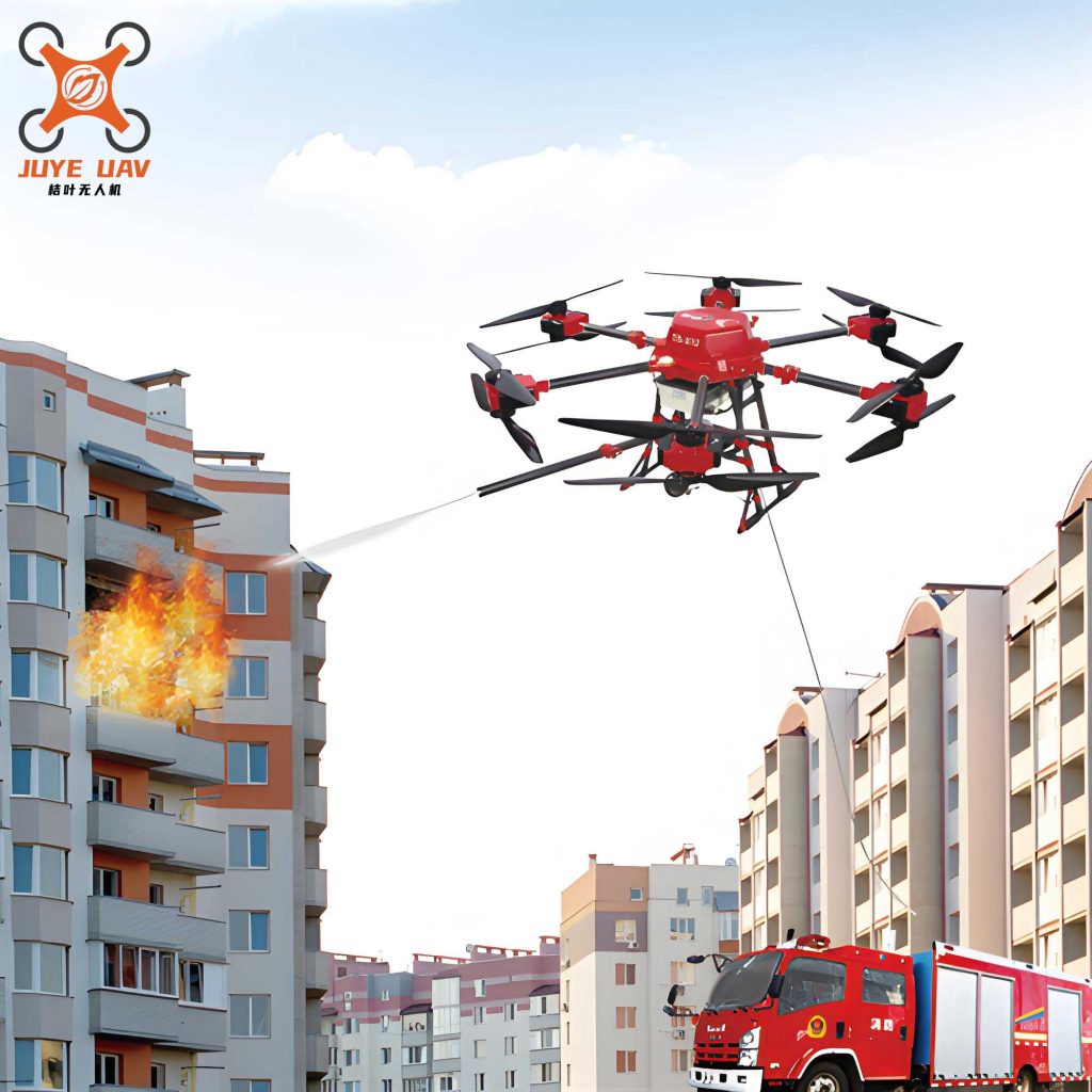
2. Active Firefighting and Rescue Support
Beyond observation, the fire UAV is evolving into an active intervention platform. This involves direct and indirect support roles.
Direct Suppression: Specialized heavy-lift fire UAVs are designed to carry and discharge extinguishing agents. Common payloads include:
- Water/Eco-foam Cannons: Precise, targeted application on hard-to-reach fire fronts or structural fires.
- Dry Chemical/Powder Dispensers: For flammable liquid (Class B) or electrical (Class C) fires.
- Compressed Air Foam Systems (CAFS): Delivering highly effective foam with greater reach and penetration than water.
- Fire Suppression Grenades/Spheres: Dropped into enclosed spaces to rapidly deploy extinguishing chemicals.
The key parameter here is the payload mass $m_{payload}$ versus the total mass $m_{UAV}$. The available flight time for suppression $t_{flight}$ is heavily dependent on this ratio and the power required for hover $P_{hover}$:
$$ t_{flight} = \frac{E_{battery} \cdot \eta}{P_{hover} + P_{payload}} \approx \frac{E_{battery} \cdot \eta}{k \cdot (m_{UAV} + m_{payload})^{3/2}} $$
where $E_{battery}$ is the battery energy, $\eta$ is the total powertrain efficiency, and $k$ is a constant related to rotor disk area and air density. This equation highlights the fundamental trade-off: carrying a larger extinguishing agent payload ($m_{payload}$) drastically reduces operational time, limiting a single fire UAV‘s standalone suppression capacity for large fires. Their role is often tactical and complementary.
Indirect Support & SAR: More commonly, the fire UAV supports ground teams. It can:
- Illuminate large areas at night with powerful LED arrays.
- Act as a temporary communications relay, creating a “cell tower in the sky” to bridge radio dead zones in complex urban or wildland terrain.
- In SAR, a thermal-equipped fire UAV can quickly scan vast areas of rubble or dense forest for heat signatures, guiding rescue teams with high efficiency. The effective search rate $R_{search}$ can be modeled as:
$$ R_{search} = v \cdot w \cdot P_{detect} $$
where $v$ is the UAV’s ground speed, $w$ is the effective sensor swath width (a function of altitude and field of view), and $P_{detect}$ is the probability of detection from the earlier equation.
3. Post-Fire Assessment and Forensic Analysis
Once a fire is controlled, the fire UAV’s role transitions to assessment. Equipped with high-resolution cameras and photogrammetry software, it can systematically document the entire scene. By flying a pre-planned grid pattern, it captures thousands of overlapping images. Software then processes these to generate highly accurate 2D orthomosaics and 3D models of the damage. The area coverage efficiency is immense compared to manual ground surveying. The total area $A$ surveyed is a product of flight time and speed, as previously indicated, but the data density (Ground Sample Distance – GSD) is crucial for detail:
$$ GSD = \frac{H \cdot s}{f} $$
where $H$ is flight altitude, $s$ is the sensor pixel size, and $f$ is the lens focal length. A lower GSD (e.g., 1 cm/pixel) means finer detail, allowing investigators to pinpoint the fire’s origin, analyze burn patterns, and accurately quantify structural damage for insurance and engineering reports. This digital twin of the scene becomes a permanent, measurable record.
Technical Advantages and Formidable Challenges
The advantages of the fire UAV—speed, safety, perspective, and cost-efficiency—are well-established. However, significant technical and operational hurdles must be overcome to realize their full potential.
Core Challenges
1. Endurance and Energy Density: This remains the single greatest limitation. Most electric multirotor fire UAVs have effective flight times of 20-45 minutes, which is often insufficient for prolonged operations like monitoring a smoldering wildfire or a large-scale SAR grid. The fundamental constraint is the specific energy of current battery technology (Lithium-polymer, Lithium-ion). While hybrid gasoline-electric systems offer longer endurance, they introduce complexity, vibration, and emissions. The quest is for a step-change in energy storage. Potential solutions include hydrogen fuel cells, which offer higher specific energy, or advanced battery chemistries (e.g., solid-state). The required energy $E_{req}$ for a mission of time $t$ is:
$$ E_{req} = P_{avg} \cdot t $$
where $P_{avg}$ is the average power draw. Until $E_{battery}$ per unit mass increases substantially, mission profiles for a fire UAV will be constrained.
2. Communication Link Stability and Security: A fire UAV is only as good as its data link. Firegrounds are electromagnetically hostile environments with intense heat, smoke, water spray, and numerous competing radio signals from emergency services. This can cause latency, dropouts, or complete loss of control (LOoC/Link). Secure, resilient communication is non-negotiable. Solutions involve:
- Frequency Diversity: Using licensed bands (e.g., 4G/LTE/5G with priority access) alongside traditional ISM bands.
- Mesh Networking: Deploying multiple fire UAVs or ground nodes that relay signals, creating a robust ad-hoc network.
- Satellite Communication (SATCOM): For beyond-line-of-sight (BLOS) operations in remote wildlands.
The link budget equation governs this:
$$ P_{rx} = P_{tx} + G_{tx} + G_{rx} – L_{path} – L_{atm} – L_{other} $$
where $P_{rx}$ is received power, $P_{tx}$ is transmit power, $G$ are antenna gains, $L_{path}$ is free-space path loss, $L_{atm}$ is atmospheric attenuation (high from water/smoke), and $L_{other}$ includes other losses. Fireground conditions severely degrade $L_{atm}$, demanding higher $P_{tx}$ or more sophisticated $G$.
3. Autonomy and Artificial Intelligence: While today’s fire UAVs are largely remotely piloted, the future lies in increased autonomy. Relying on a single pilot’s sustained concentration in a high-stress environment is suboptimal. Key AI development areas include:
- Intelligent Path Planning: Automatically navigating around obstacles (trees, wires, structures) while optimizing sensor coverage.
- Automated Target Recognition (ATR): Using computer vision (CV) and machine learning (ML) to automatically flag potential victims, hotspots, or structural anomalies in real-time video streams, reducing operator cognitive load.
- Swarm Intelligence: Coordinating multiple heterogeneous fire UAVs—some for mapping, some for suppression, some as relays—to act as a cohesive system. This involves complex multi-agent coordination algorithms.
A basic autonomous navigation model involves solving for an optimal trajectory $x^*(t)$ that minimizes a cost function $J$ (e.g., time, energy) while respecting dynamics $f$, obstacle constraints $g$, and mission goals $h$:
$$ \begin{aligned}
& \underset{x(t), u(t)}{\text{minimize}}
& & J = \int_{t_0}^{t_f} L(x(t), u(t)) \, dt \\
& \text{subject to}
& & \dot{x}(t) = f(x(t), u(t)), \\
& & & g(x(t)) \leq 0, \\
& & & h(x(t_f)) = 0.
\end{aligned} $$
4. Payload Integration and Environmental Hardening: A fire UAV must operate in extreme conditions: high temperatures, corrosive smoke, water immersion, and impact risks. Airframes and electronics need rigorous hardening. Furthermore, payloads (thermal cameras, LiDAR, dispenser systems) must be seamlessly integrated, both mechanically and digitally, to provide a unified data stream to the operator.
Strategic Improvement Pathways
Addressing these challenges requires a concerted, multi-faceted strategy:
- Power System Innovation: Prioritize R&D into next-generation power systems. This includes not just hydrogen fuel cells, but also rapid charging/swapping solutions at the incident command post to enable persistent “loiter-and-rotate” operations.
- Resilient Comms Architecture: Develop and standardize a fire-service-specific communication protocol stack that integrates 5G, mesh, and SATCOM with automatic failover, strong encryption, and spectrum-agile radios.
- AI for Firegrounds: Foster collaboration between AI researchers and firefighting experts to create and train robust ML models on diverse, real-world fireground data. Develop shared simulation environments for testing autonomy algorithms.
- Modular & Standardized Design: Promote open architecture standards for fire UAV payload interfaces, allowing departments to mix and match sensors and tools from different vendors, fostering innovation and reducing costs.
Regulatory and Policy Landscape: A Comparative Analysis
The operational ceiling for any fire UAV is often defined not by technology, but by regulation. The legal frameworks governing their use are complex and vary significantly.
Domestic Policy Framework
In many countries, aviation authorities provide a regulatory structure. Typically, fire departments operate under specific provisions for public safety aircraft. Key permissions often include:
- Beyond Visual Line of Sight (BVLOS) Waivers: Essential for large-area searches or wildland fire mapping.
- Operations Over People (OOP) and in Controlled Airspace: Critical for urban firefighting, often requiring rigorous risk mitigation plans.
- Pilot Certification: Requiring pilots to hold specific remote pilot licenses with public safety endorsements.
The regulatory process is often iterative, where aviation authorities work with agencies to develop safe operational protocols based on demonstrated need and capability.
International Regulatory Comparison
A comparative analysis reveals different philosophical and risk-based approaches:
| Region/Country | Regulatory Body | Key Features for Public Safety UAVs | Notable Emphasis |
|---|---|---|---|
| United States | FAA (Federal Aviation Administration) | Part 107 rules, COAs (Certificates of Waiver or Authorization) for public agencies, LAANC for airspace access. | Integrated airspace access, rigorous waiver process for BVLOS/OOP. |
| European Union | EASA (European Union Aviation Safety Agency) | EU 2019/947 & 2019/945 regulations, “Specific” category operations with operational authorizations based on risk assessment (SORA). | Risk-based, granular categorization. Standardized rules across member states. |
| Canada | Transport Canada | SFOC (Special Flight Operations Certificate) for complex operations, Advanced Operations pilot certificate. | Focus on pilot competency and operational risk management plans. |
Policy Recommendations for Accelerated Adoption
- Enhanced Policy Guidance and Funding: Governments should issue clear national strategies endorsing fire UAV integration, backed by dedicated grant funding for acquisition, training, and R&D.
- Streamlined Regulatory Pathways: Aviation authorities should work with fire services to create pre-approved, standardized operational templates for common scenarios (e.g., wildfire mapping, urban structure fire assessment) to expedite authorization.
- Robust Oversight and Standards Development: Establish independent technical standards for fire UAV hardware resilience, data security, and operator training to ensure safety and interoperability across jurisdictions.
- Promotion of Open Innovation: Policies should encourage public-private partnerships and open-data initiatives to accelerate the development of AI tools and specialized payloads for the fire service.
- International Harmonization: Pursue international agreements to simplify cross-border operations during major wildfires or disaster relief efforts, addressing issues of spectrum use, pilot licensing reciprocity, and airspace coordination.
Future Trajectories and Concluding Perspectives
The trajectory for fire UAV technology is decisively upward, converging with broader trends in robotics, AI, and telecommunications.
Technology Trend Projections
| Trend Area | Short-Term (2-5 years) | Mid-Term (5-10 years) | Long-Term (10+ years) |
|---|---|---|---|
| Propulsion & Endurance | Improved Li-ion packs, rapid swap systems, hybrid gensets. | Commercialization of hydrogen fuel cell systems for UAVs. | Potential for ultra-capacitors or new physics-based storage. |
| Autonomy & AI | Advanced obstacle avoidance, simple automated inspection routines. | Widespread use of AI for real-time data analysis (hotspot/victim detection). | Fully autonomous collaborative swarms for complex suppression tasks. |
| Sensors & Payloads | Miniaturization of hyperspectral, better low-light/thermal. | Integrated multi-sensor “fusion” pods with on-edge AI processing. | Novel sensors (e.g., microwave for seeing through walls). |
| Communications | Widespread use of 5G for command and HD video. | Integrated air-ground mesh networks as standard fire service equipment. | Quantum-key-distribution for ultra-secure links. |
Expanded Application Horizons
The future fire UAV will be a versatile node in a larger “Internet of Emergency Things.” We will see:
- Pre-Incident Planning and Inspection: Routine automated fire UAV flights for building facade inspection, wildland fuel load mapping, and pre-fire planning of critical infrastructure, creating rich digital baselines.
- Hazardous Material (HazMat) Response: UAVs equipped with advanced chemical, biological, radiological, and nuclear (CBRN) sensors to map plume dispersion and identify substances without exposing personnel.
- Integrated Disaster Management: Beyond fire, fire UAV platforms will be standard for flood assessment, earthquake damage surveys, and storm aftermath documentation, maximizing the return on public safety investment.
In conclusion, the fire UAV has irrevocably altered the firefighting operational landscape. It is a force multiplier that enhances situational awareness, protects firefighters, and improves community outcomes. While significant challenges in endurance, communication, autonomy, and regulation persist, they are not insurmountable barriers but rather focal points for concentrated innovation. The path forward requires sustained collaboration between firefighters, engineers, regulators, and policymakers. By investing in technology development, crafting adaptive regulations, and committing to comprehensive training, we can ensure that the fire UAV evolves from a valuable tool into an indispensable, intelligent partner in safeguarding lives and property against the threat of fire. The mission is clear: to harness the full potential of robotic aviation to create a safer, more responsive future for emergency services worldwide.