
The convergence of information and communication technology, artificial intelligence, big data, and other novel technologies with traditional industries has ushered in unprecedented opportunities for innovation in products, services, and operational models within firefighting and emergency response. Annually, natural disasters, accidents, and fires inflict immense human and economic tolls. The application of drone technology in the fire service is fundamentally altering this landscape. Compared to conventional firefighting and rescue methods, fire drones, with their inherent flexibility and operational simplicity, have rapidly gained favor among fire departments. These unmanned systems can swiftly penetrate disaster zones, capturing critical imaging data in real-time, thereby enhancing operational efficiency and significantly reducing risks to personnel. With relentless technological progress, the capabilities of modern fire drones have advanced exponentially. In fire service applications, they are now adept at operating in complex environments. By integrating payloads such as infrared thermal imaging cameras, LiDAR, and emergency communication modules, fire drones can perform urgent search and rescue, aerial supply drops, and airborne communication relay, effectively addressing numerous limitations of traditional response methods. They provide powerful data support for the scientific deployment of firefighting resources, cementing their status as an indispensable component of modern emergency response.
Technical Characteristics and Classification of Fire Drones
Unmanned Aerial Vehicles (UAVs), or drones, are pilotless aircraft controlled via radio or pre-programmed computer instructions. Their core technological foundation encompasses autonomous flight control, long-range imaging and measurement, GNSS positioning (GPS, BeiDou, GLONASS, Galileo), and robust data transmission systems. This suite enables autonomous mapping of incident scenes, acquisition of high-definition imagery, and precise topographical surveying. Fire drones can transmit geospatial data and remote sensing imagery, which is then processed for modeling, analysis, and operational intelligence.
Key Characteristics of Fire Drones
The operational advantages of fire drones in contemporary emergency response are multifaceted, primarily focusing on three areas: Precision Monitoring, High Cost-Effectiveness, and Operational Safety & Flexibility.
Precision Monitoring: Operating primarily at low altitudes, fire drones excel in close-range measurement tasks. In specific engineering and emergency survey applications, the measurement accuracy achievable by drone-based photogrammetry can reach centimeter-level precision. The spatial resolution $R_s$ of an image captured from a drone can be approximated by:
$$R_s = \frac{(S_w \times H)}{(f \times I_w)}$$
Where $S_w$ is the sensor width, $H$ is the flight altitude, $f$ is the lens focal length, and $I_w$ is the image width in pixels. This allows for detailed scene reconstruction.
High Cost-Effectiveness: The manufacturing and operational costs of fire drones, particularly multi-rotor systems, are relatively low. They are less susceptible to interference that affects larger, manned systems. Furthermore, their payload capacity allows for the integration of specialized instruments (e.g., gas detectors, multi-spectral cameras) without a prohibitive cost increase, resulting in a high utility-to-cost ratio. A simplified cost-benefit metric $C_{eff}$ for deployment can be considered:
$$C_{eff} = \frac{(A_{covered} \times D_{resolution} \times P_{safety})}{C_{operation}}$$
Where $A_{covered}$ is the area surveilled, $D_{resolution}$ is the data resolution, $P_{safety}$ is the relative safety factor for personnel, and $C_{operation}$ is the operational cost.
Safety and Flexibility: Fire drones have minimal takeoff and landing requirements, enabling deployment in confined or hazardous areas. Their flight paths can be adjusted in real-time based on evolving on-scene conditions. The piloting interface has also been significantly simplified, allowing for rapid operator training and deployment.
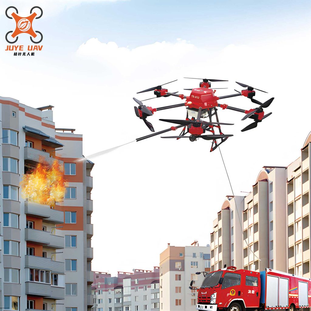
Classification of Fire Drones
Continuous innovation in flight controllers and autopilots has matured drone technology. Fire drones are commonly classified by airframe design and power source.
By Airframe Design:
- Fixed-Wing Drones: Resemble traditional airplanes. They are efficient for long-endurance, large-area mapping but typically require space for takeoff and landing and cannot hover.
- Single-Rotor Helicopter Drones: Function like traditional helicopters. They offer vertical takeoff and landing (VTOL) and good payload capacity but are mechanically complex.
- Multi-Rotor Drones (e.g., Quadcopters, Hexacopters): The most common type for tactical fire service use. They offer exceptional stability, precise hovering, VTOL, and ease of control, making them ideal for close-range inspection, monitoring, and payload delivery.
By Power Source: This classification is critical for mission planning in firefighting.
| Power Type | Fuel Source | Key Advantages | Primary Limitations |
|---|---|---|---|
| Electric (Battery-Powered) | Lithium Polymer (LiPo) Batteries | Lower noise signature, immediate readiness, simpler maintenance, higher intrinsic safety (no flammable fuel), zero emissions at point of use. | Limited flight endurance (typically 20-45 minutes for multi-rotors under load), battery performance degradation in extreme cold. |
| Internal Combustion (Fuel-Powered) | Gasoline or Diesel | Superior flight endurance (several hours), often better suited for heavy payloads and large fixed-wing models. | Higher noise, vibration, exhaust emissions, requires fuel handling, more complex maintenance, potential fire risk if damaged. |
The flight time $T_{flight}$ for an electric multi-rotor fire drone can be estimated using:
$$T_{flight} = \frac{(C_{batt} \times V_{batt} \times \eta)}{(P_{avg})}$$
Where $C_{batt}$ is battery capacity in Amp-hours, $V_{batt}$ is voltage, $\eta$ is the power system efficiency (typically 0.7-0.8), and $P_{avg}$ is the average power draw in Watts during flight, which is a function of weight, aerodynamics, and hover efficiency.
Applications of Drone Technology in Firefighting and Emergency Rescue
The use of drones in disaster response began in the 1990s in technologically advanced nations. Adoption in China’s fire and rescue services accelerated following the 2008 Wenchuan earthquake, where aerial imagery from reconnaissance drones proved invaluable. Since then, through responses to earthquakes, landslides, and major industrial accidents, fire drones have demonstrated their unique advantages in optimizing resource allocation, identifying critical areas, planning safe access routes, and supporting post-disaster analysis.
1. Disaster Scene Reconnaissance
Traditional fireground or disaster scene size-up is often constrained by terrain, structural instability, and environmental hazards, posing significant risks to firefighters. Equipped with high-definition and thermal imaging cameras, a fire drone provides a rapid, overhead perspective, unimpeded by ground-level obstacles. In environments deemed too hazardous for personnel—such as those with toxic gases, imminent structural collapse, or explosive atmospheres—the fire drone becomes the primary reconnaissance tool. This capability provides incident commanders with comprehensive, real-time situational awareness, forming the basis for informed tactical decisions and inherently enhancing responder safety.
2. Real-Time Monitoring and Situational Awareness
Disaster scenes are dynamic. A fire drone dedicated to persistent monitoring can track the progression of a wildfire, floodwaters, or the stability of a compromised structure. The live video feed is transmitted to command vehicles and headquarters, allowing all levels of leadership to maintain a common operational picture. This enables agile adaptation to sudden changes (e.g., wind shift in a wildfire, secondary collapse) and more effective coordination of multi-agency resources, ultimately minimizing casualties and property loss. Advanced drones can also be equipped with sensors to detect chemical, biological, radiological, or nuclear (CBRN) agents, providing early warning and hazard demarcation.
3. Auxiliary Rescue Operations
When integrated with specialized payloads, the fire drone transitions from an observation platform to an active rescue asset. Its auxiliary functions manifest in three primary modes:
A. Aerial Command and Communication (Voice/Loudspeaker): A fire drone equipped with a loudspeaker or bidirectional communication system can broadcast evacuation instructions to survivors, deliver commands to isolated response teams, or communicate with individuals trapped in high-rise buildings, cliffs, or flood islands where traditional communication is ineffective.
B. Precision Payload Delivery: This is a critical function where the fire drone acts as a logistical carrier. It can deliver essential supplies such as life jackets, emergency medical kits, food, water, or communication devices to victims or responders in inaccessible areas. For time-sensitive medical emergencies, a fire drone can deliver automated external defibrillators (AEDs) or antidotes faster than ground units, dramatically improving survival odds. The payload capacity $W_{payload}$ is a key metric:
$$W_{payload} = T_{max} – (W_{airframe} + W_{battery})$$
Where $T_{max}$ is the maximum thrust generated by the propulsion system, $W_{airframe}$ is the weight of the drone itself, and $W_{battery}$ is the weight of the power source.
C. Emergency Mapping and 3D Modeling: By mounting oblique or nadir-facing cameras, a fire drone can rapidly collect overlapping imagery. Using photogrammetry software and powerful GPUs, this imagery is processed to generate highly accurate 2D orthomosaics and 3D models of the disaster area. These models provide commanders with an immersive, dimensionally accurate view for planning complex extrications, assessing structural damage, calculating water or debris volume, and creating pre-incident plans for high-risk sites. The process involves solving the collinearity equations for thousands of images:
$$x – x_0 = -f \frac{[m_{11}(X – X_L) + m_{12}(Y – Y_L) + m_{13}(Z – Z_L)]}{[m_{31}(X – X_L) + m_{32}(Y – Y_L) + m_{33}(Z – Z_L)]}$$
$$y – y_0 = -f \frac{[m_{21}(X – X_L) + m_{22}(Y – Y_L) + m_{23}(Z – Z_L)]}{[m_{31}(X – X_L) + m_{32}(Y – Y_L) + m_{33}(Z – Z_L)]}$$
Where $(x, y)$ are image coordinates, $(X, Y, Z)$ are object space coordinates, $(X_L, Y_L, Z_L)$ are the drone’s camera position, $f$ is focal length, $(x_0, y_0)$ are principal point offsets, and $m_{ij}$ are elements of the rotation matrix.
4. Emergency Communication Relay and Mesh Networks
Large-scale disasters often cripple terrestrial communication infrastructure due to physical damage or network overload. While satellite communication is an alternative, it can be limited by bandwidth, latency, or equipment availability. The fire drone offers a novel, agile solution for re-establishing connectivity.
The primary limitation for standard electric fire drones in this role is endurance. The breakthrough comes with tethered drone systems and advancements in hybrid power. A tethered fire drone is physically connected to a ground-based power supply and control station via a lightweight tether containing power and fiber-optic data lines. This allows for continuous, 24/7 flight at altitudes of 100-200 meters, acting as a persistent aerial communication cell tower or Wi-Fi hotspot. The effective communication coverage radius $R_{cov}$ for an aerial platform can be approximated by:
$$R_{cov} \approx \sqrt{(2 \times R_e \times h)} + \sqrt{(2 \times R_e \times h_{terminal})}$$
Where $R_e$ is the effective Earth radius (∼8500 km for radio waves), $h$ is the altitude of the drone-mounted antenna, and $h_{terminal}$ is the height of the user’s device. Doubling the drone’s altitude significantly extends the line-of-sight coverage area. Furthermore, swarms of intelligent fire drones can form airborne mesh networks, creating a resilient, self-healing communication blanket over vast and complex incident areas, ensuring uninterrupted command and control as well as data backhaul.
The following table summarizes the core applications and their technological underpinnings:
| Application Domain | Primary Drone Function | Key Enabling Payloads/Technologies | Operational Impact |
|---|---|---|---|
| Reconnaissance & Monitoring | Eyes in the Sky | HD/Zoom Cameras, Infrared (Thermal) Imagers, LiDAR, Multispectral Sensors | Enhanced Situational Awareness, Reduced Risk to Personnel, Rapid Scene Assessment |
| Auxiliary Rescue | Aerial Workhorse | Loudspeakers, Payload Release Mechanisms, Delivery Cages, Grippers, Oblique Camera Arrays | Direct Victim Assistance, Logistical Support, High-Fidelity Mapping for Tactical Planning |
| Emergency Communication | Airborne Cell Tower | Tethered Power Systems, 4G/5G/LTE Micro-Cells, Mesh Network Routers, Radio Repeaters | Restored Command & Control, Guaranteed Data Links in Denied Areas |
Future Trajectory and Conclusion
Years of domestic and international operational deployment have solidified the critical role of fire drones in public safety, garnering increased investment and focus from government and emergency service organizations globally. The advent of higher-fidelity communication technologies, particularly 5G, promises another revolutionary leap. The ultra-reliable, low-latency communication (URLLC) and enhanced mobile broadband (eMBB) features of 5G will provide fire drones with seamless, high-bandwidth data links. This enables real-time streaming of ultra-high-definition and 360-degree video, instantaneous transfer of massive LiDAR point clouds, and robust control of drone swarms for coordinated tasks.
The future will likely see the proliferation of fire drone-as-a-relay models, powered by AI-driven autonomous operation. These systems will feature rapid self-deployment, adaptive flight path planning for optimal coverage, and intelligent data processing at the edge (on the drone itself) to deliver only the most critical insights to commanders. The integration of advanced sense-and-avoid systems will allow for safe BVLOS (Beyond Visual Line of Sight) operations in congested airspace. A resilient and automated command-and-data ecosystem is the foundational guarantee for realizing the full potential of the fire drone—from rapid deployment and detailed reconnaissance to persistent monitoring, active auxiliary rescue, and ubiquitous emergency communication. By continuously harnessing these technological advantages, fire drone fleets will become a central pillar in comprehensive disaster response strategies, profoundly elevating the efficacy and safety standards of firefighting and emergency rescue missions worldwide.