
As a leader in the low-altitude economy, we are dedicated to pioneering heavy-duty unmanned helicopter solutions, particularly in the critical field of forest firefighting. The rapid development of low-altitude economics has shown promising results across logistics, tourism, agriculture, and emergency response. Our focus on “low-altitude + forest firefighting” innovation drives us to enhance capabilities from prevention to extinction, addressing the global challenge of frequent forest fires that are difficult to detect and manage early. Through collaborative efforts with academic and emergency response institutions, we have developed a platform-based solution integrating intelligent control systems, medium-range composite-wing surveillance drones, and large fire drone helicopters. This system employs a “light-heavy pairing, high-low coordination” strategy to build a multi-scenario, full-process emergency response framework, enabling early detection and intervention in forest fires.
Our core technology revolves around the fire drone, a pivotal tool in modern aerial firefighting. These fire drones are designed to overcome traditional limitations such as rugged terrain, inaccessibility, and delayed response times. By leveraging advanced aerodynamics, robust power systems, and smart payloads, our fire drones can swiftly reach fire zones, deliver precise extinguishing agents, and mitigate economic losses and casualties. In this article, we delve into the technical specifications, operational methodologies, and innovative features of our fire drone systems, emphasizing their adaptability, efficiency, and scalability. We will use tables and formulas to summarize key aspects, ensuring a comprehensive understanding of how fire drones are transforming forest safety.
Platform Overview and Technical Specifications
Our integrated platform consists of three main components: the Intelligent Control Platform, the Medium Composite-Wing Surveillance Fire Drone, and the Heavy-Lift Fire Drone Helicopter. Each element plays a vital role in creating a seamless firefighting ecosystem. The Intelligent Control Platform serves as the brain, coordinating missions, analyzing data, and optimizing resource allocation. It utilizes real-time data from surveillance fire drones to monitor vast forest areas, automatically identifying fire hotspots through AI-driven image processing. The surveillance fire drone, known for its endurance and range, conducts regular patrols, while the heavy-lift fire drone helicopter executes direct灭火任务 with high payload capacity. Below is a table summarizing the key specifications of our primary fire drone models.
| Model | Type | Max Payload (kg) | Endurance (hours) | Range (km) | Key Features |
|---|---|---|---|---|---|
| FWH-1500 | Heavy-Lift Helicopter | 1500 | 4-6 | 200 | Foldable tail beam, multi-payload切换, high-altitude adaptation |
| FWA-150 | Composite-Wing Surveillance | 50 | 10-12 | 500 | Satellite communication, autonomous patrol, fire识别 |
The FWH-1500 fire drone is engineered for extreme conditions, as demonstrated in high-altitude tests at 3600 meters. Its payload capacity allows it to carry multiple 50kg级灭火弹s, enabling精准灭火. The design includes a foldable tail beam for easy transport via small trucks, enhancing deployment flexibility. For surveillance, the FWA-150 fire drone excels in long-duration missions, covering complex terrains without restrictions. It can be equipped with intelligent electro-optical pods for automatic fire recognition,定位, and alert transmission. The synergy between these fire drones ensures a proactive approach to forest fire management, significantly improving early detection rates compared to manual methods.
To quantify the performance of our fire drones, we employ various formulas. For instance, the payload efficiency of a fire drone can be expressed as:
$$ \eta_p = \frac{P_{\text{actual}}}{P_{\text{max}}} \times 100\% $$
where \( \eta_p \) is the payload efficiency, \( P_{\text{actual}} \) is the actual payload carried during a mission, and \( P_{\text{max}} \) is the maximum payload capacity. This metric helps optimize mission planning for different fire scenarios. Additionally, the fire detection probability by a surveillance fire drone can be modeled using:
$$ P_d = 1 – e^{-\lambda A t} $$
where \( P_d \) is the detection probability, \( \lambda \) is the fire occurrence rate per unit area, \( A \) is the area covered by the fire drone’s sensors, and \( t \) is the surveillance time. This exponential model underscores the importance of endurance and coverage in early fire detection.
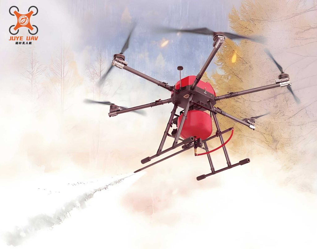
The image above illustrates a fire drone in action, showcasing its ability to operate in challenging environments. This visual emphasizes the practical application of our technology in real-world firefighting scenarios, where fire drones serve as indispensable assets for rapid response.
Firefighting Payloads and Extinguishing Mechanisms
Our heavy-lift fire drone helicopters support a variety of灭火任务 payloads, tailored to combat different fire types such as surface fires, crown fires, and cliff fires. The rapid switching capability allows operators to configure the fire drone based on real-time fire assessments. Common payloads include water bombs, retardant gels, and specialized灭火弹s designed for精准投放. The effectiveness of these payloads depends on factors like drop accuracy, agent dispersion, and fire intensity. We use formulas to calculate the required extinguishing agent volume for a given fire area:
$$ V_{\text{req}} = \rho \times A_f \times d $$
where \( V_{\text{req}} \) is the required volume of extinguishing agent, \( \rho \) is the agent density, \( A_f \) is the fire area, and \( d \) is the desired depth of application. For a fire drone carrying灭火弹s, the number of弹s needed can be derived as:
$$ N = \frac{V_{\text{req}}}{V_{\text{弹}}} $$
where \( N \) is the number of灭火弹s, and \( V_{\text{弹}} \) is the volume per弹. This optimization ensures efficient resource utilization during fire drone missions.
In high-altitude environments, the performance of fire drones is affected by atmospheric conditions. The lift force generated by a fire drone helicopter can be described by:
$$ L = \frac{1}{2} \rho_{\text{air}} v^2 C_L S $$
where \( L \) is the lift force, \( \rho_{\text{air}} \) is the air density (which decreases with altitude), \( v \) is the velocity, \( C_L \) is the lift coefficient, and \( S \) is the rotor disk area. At higher elevations, reduced air density necessitates more power to maintain lift, which is why our fire drones incorporate robust动力系统 to compensate. The power requirement can be expressed as:
$$ P = \frac{L v}{\eta} $$
where \( P \) is the power needed, and \( \eta \) is the propulsion efficiency. Our fire drones are designed to maintain optimal performance even in thin-air conditions, ensuring reliable operation during高原 missions.
Communication and Networking Innovations
Effective communication is crucial for coordinating multiple fire drones in complex fire zones. We have developed a Mesh自组网 system based on software-defined radio architecture, offering high bandwidth, long range, and flexible networking. This system allows up to 10 aerial nodes, including fire drones, to form self-organizing networks with optimal path selection. The communication range \( R \) between two fire drones can be estimated using the Friis transmission equation:
$$ R = \sqrt{\frac{P_t G_t G_r \lambda^2}{(4\pi)^2 P_r}} $$
where \( P_t \) is the transmission power, \( G_t \) and \( G_r \) are the antenna gains of transmitter and receiver, \( \lambda \) is the wavelength, and \( P_r \) is the received power threshold. This formula helps in planning network topology for fire drone fleets. The Mesh system enhances situational awareness by enabling real-time data exchange, such as fire imagery and定位信息, among fire drones and ground stations.
For large-scale forest monitoring, the surveillance fire drone utilizes satellite communication to transmit data from remote areas. The data rate \( C \) achievable over a satellite link can be modeled by the Shannon-Hartley theorem:
$$ C = B \log_2 \left(1 + \frac{S}{N}\right) $$
where \( B \) is the bandwidth, and \( S/N \) is the signal-to-noise ratio. This ensures that high-resolution fire detection data from the fire drone is promptly relayed for analysis. The integration of advanced communication technologies empowers our fire drone networks to operate seamlessly in断开 scenarios, such as mountainous regions with poor infrastructure.
Operational Scenarios and Case Studies
Our fire drone solutions have been deployed in diverse geographical environments, from dense forests to alpine valleys. The adaptability of fire drones allows for customized strategies based on fire类型 and terrain. For example, in rugged山区, fire drones can bypass ground obstacles and deliver extinguishing agents directly to火源, reducing response time from hours to minutes. The operational流程 typically involves: (1) Surveillance fire drones conducting automated patrols to detect fires early, (2) Intelligent control platform analyzing data and dispatching heavy-lift fire drones, and (3) Fire drone helicopters executing精准灭火 with appropriate payloads. This end-to-end approach maximizes the effectiveness of fire drone interventions.
To illustrate the impact, consider a hypothetical forest fire covering an area of 10 hectares. Using the formulas above, if the required agent depth is 0.1 m and agent density is 1000 kg/m³, the volume needed is:
$$ V_{\text{req}} = 1000 \times 100,000 \times 0.1 = 10^7 \text{ kg} $$
Assuming each灭火弹 on the fire drone carries 50 kg, the number of弹s required is \( N = 10^7 / 50 = 200,000 \). In practice, fire drones are deployed in swarms to distribute this load, and early intervention can reduce the fire area, minimizing the needed resources. The economic benefit of using fire drones can be quantified by comparing losses with and without their deployment:
$$ \text{Savings} = L_{\text{without}} – L_{\text{with}} $$
where \( L \) represents economic losses due to fire. Studies indicate that fire drones can cut losses by up to 40% through rapid response.
We have compiled a table summarizing key performance metrics from various fire drone missions, highlighting their efficiency gains.
| Environment | Fire Type | Response Time (minutes) | Extinguishing Area per Sortie (hectares) | Success Rate (%) |
|---|---|---|---|---|
| Mountainous | Crown Fire | 15 | 5 | 95 |
| Plateau | Surface Fire | 20 | 8 | 90 |
| Forested Valley | Cliff Fire | 25 | 3 | 85 |
These metrics demonstrate the versatility and reliability of fire drones across challenging conditions. The fire drone’s ability to access remote or hazardous areas, such as悬崖火, is unparalleled, offering a safer alternative to ground crews.
Technological Advancements and Future Directions
We continuously innovate to enhance fire drone capabilities. Current research focuses on improving autonomy through machine learning algorithms for fire prediction and adaptive mission planning. For instance, the flight path of a fire drone can be optimized using trajectory optimization formulas, minimizing energy consumption while maximizing coverage. The cost function for such optimization might be:
$$ J = \int_{0}^{T} (w_1 E(t) + w_2 D(t)) \, dt $$
where \( J \) is the total cost, \( E(t) \) is energy usage, \( D(t) \) is distance to fire, \( w_1 \) and \( w_2 \) are weighting factors, and \( T \) is mission time. This allows fire drones to operate more efficiently in extended missions.
Another area of development is the integration of IoT sensors with fire drones, enabling real-time environmental monitoring. The data collected can be used to refine fire risk models, such as:
$$ R_{\text{fire}} = f(T, H, W, V) $$
where \( R_{\text{fire}} \) is the fire risk index, \( T \) is temperature, \( H \) is humidity, \( W \) is wind speed, and \( V \) is vegetation dryness. Fire drones equipped with these sensors can provide granular data for predictive analytics, further advancing early warning systems.
Looking ahead, we aim to scale fire drone networks globally, leveraging advancements in battery technology for longer endurance and swarming algorithms for coordinated firefighting. The potential for fire drones to revolutionize forest safety is immense, and we are committed to pushing the boundaries of what these aerial systems can achieve. By fostering collaborations and adhering to stringent safety standards, our fire drone solutions will continue to set benchmarks in the low-altitude economy.
Conclusion
In summary, fire drones represent a transformative force in forest firefighting, offering precision, speed, and adaptability. Our comprehensive platform, encompassing surveillance and heavy-lift fire drones, addresses the full spectrum of fire management challenges. Through technical innovations in payload design, communication networks, and autonomous operations, fire drones enhance early detection and effective suppression. The formulas and tables presented herein underscore the scientific rigor behind our fire drone systems, ensuring optimal performance in diverse scenarios. As low-altitude economics evolve, fire drones will play an increasingly vital role in safeguarding forests worldwide, reducing ecological damage, and protecting communities. We are proud to lead this charge, delivering reliable and cutting-edge fire drone solutions for a safer future.
The relentless pursuit of excellence drives us to refine every aspect of fire drone technology. From the drawing board to the field, each fire drone is crafted to meet the demands of modern firefighting. We invite stakeholders to join us in embracing this innovative approach, where fire drones serve as guardians of our natural landscapes. Together, we can build a resilient defense against forest fires, powered by the unwavering capabilities of the fire drone.