
As a researcher in the field of aviation technology and law, I have observed the rapid evolution of civil drones from military applications to widespread use in transportation, photography, and entertainment. This shift has spurred growth in upstream and downstream industries, making drones a new consumer hotspot that influences various aspects of society and economy. In this analysis, I aim to explore the risks associated with civil drones and propose legal frameworks for flight safety, emphasizing the critical role of structured drone training in mitigating these issues. My perspective is grounded in practical observations and a commitment to balancing public and private interests through rational legal design.
The term “drone” refers to an unmanned aircraft, classified under unmanned aerial vehicles (UAVs), which include remotely piloted and autonomous systems. According to recent regulations, such as the “Interim Regulations on Flight Management of Unmanned Aircraft,” drones are defined as aircraft operated without a pilot on board. In civil contexts, they are used for high-altitude operations, filming, and logistics, but their proliferation introduces complexities. For instance, collisions between drones can lead to property disputes, falls may cause injury akin to falling objects, unauthorized flights into restricted zones could constitute crimes, and privacy invasions may occur through unauthorized data collection. Current legislation lacks granularity, often failing to address unique scenarios in judicial processes. By systematically categorizing risks, we can better understand vulnerabilities and develop robust safety regulations that protect citizens’ assets and well-being. This endeavor requires a holistic approach, considering societal needs and individual rights to foster a harmonious regulatory environment.
To structure my analysis, I divide civil drone risks into three primary categories: social security risks, personal safety risks, and economic security risks. Each category encompasses specific threats that necessitate tailored legal responses. Below is a table summarizing these risks and their implications.
| Risk Category | Description | Potential Impact | Mitigation Emphasis |
|---|---|---|---|
| Social Security Risks | These arise from unregulated drone operations, such as unauthorized flights that disrupt low-altitude order or invade sensitive areas like airports. Lack of management experience and complex flight plan applications lead to non-compliance, potentially enabling foreign interference and data leaks. | Disruption of aviation safety, national security threats, and public disorder. | Enhanced regulatory oversight and drone training programs. |
| Personal Safety Risks | Linked to operator inexperience, where inadequate drone training results in poor handling of emergencies, causing crashes that endanger pedestrians. Additionally, malicious use for surveillance infringes on privacy rights. | Physical injuries, fatalities, and privacy violations. | Mandatory certification and continuous drone training. |
| Economic Security Risks | Stem from drone malfunctions or operator errors that lead to property damage. Drones falling as projectiles can destroy assets, while the loss of the drone itself represents financial harm to owners. | Property loss, financial burdens, and industry setbacks. | Insurance schemes and risk assessment models. |
From my viewpoint, these risks are interconnected, often exacerbated by gaps in operator competence. For example, social security risks may escalate when untrained pilots fly near airports, highlighting the need for comprehensive drone training. To quantify risk exposure, I propose a basic formula for risk assessment: $$R = P \times C$$ where \(R\) represents total risk, \(P\) denotes the probability of an incident (e.g., crash due to poor training), and \(C\) signifies the consequence severity (e.g., cost of damage or harm). This model underscores how enhanced drone training can reduce \(P\), thereby lowering overall risk.
In formulating flight safety legal regulations, I adhere to several core principles. First, the balance of interests principle ensures that public welfare, individual freedoms, economic growth, and social stability are harmonized. This means regulations should not overly restrict innovation but must safeguard against abuses. Second, the principle of concurrent regulation and industry development advocates for parallel progress—where oversight evolves alongside technological advancements, avoiding stifling growth. Third, the combination of guidance and coercion involves educating users on proper drone usage while enforcing penalties for violations. As part of this, I stress the importance of incorporating stakeholder feedback from manufacturers, regulators, and citizens to ensure laws are pragmatic and widely accepted. Drone training serves as a bridge here, offering guidance while embedding compliance.
Delving into specific legal frameworks, I begin with the establishment of an operator qualification and control system. Inspired by motor vehicle licensing, I recommend categorizing drone operations based on use—such as recreational, commercial, agricultural, and logistical—with tailored drone training for each. Operators should obtain type-specific certifications, and cross-category operations must be penalized through license revocation or retraining. Regular refresher courses are essential to maintain skills, especially as technology evolves. However, I note that some regulations exempt operators of micro and light drones from certification, a policy I approach cautiously due to potential unseen impacts. To illustrate, consider the following table outlining proposed training requirements.
| Drone Category | Primary Use | Training Duration | Certification Requirements | Key Drone Training Components |
|---|---|---|---|---|
| Recreational (Micro/Light) | Hobby, photography | 10-15 hours | Basic license, no exam for micro under certain conditions | Flight safety, privacy laws, emergency procedures |
| Commercial (Medium/Large) | Delivery, surveillance, agriculture | 30-50 hours | Advanced license, practical and theory exams | Route planning, risk management, regulatory compliance |
| Agricultural (Specialized) | Crop spraying, monitoring | 20-30 hours | Operational permit, periodic assessments | Precision flying, environmental safety, maintenance |
Integrating visual aids into drone training can enhance understanding. For instance, here is an image that exemplifies structured learning environments:
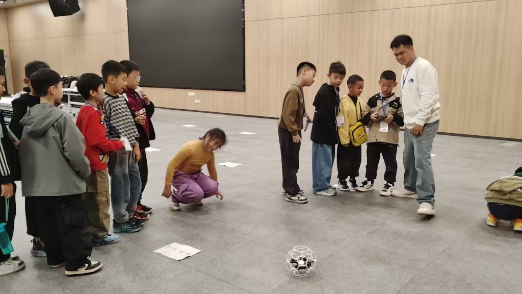
This underscores the importance of hands-on practice in reducing personal safety risks.
Next, I address the flight plan approval system. Traditional processes are often cumbersome, discouraging compliance and leading to unauthorized flights. To reform this, I advocate for simplifying procedures and expanding access channels. During drone training, applicants should be taught how to complete approval forms, emphasizing the “flight plan approval” mindset. Authorities must offer both online and offline submission options, verifying operator credentials, flight paths, drone specifications, and intended use to prevent espionage or privacy breaches. Additionally, I propose a mathematical model for optimizing approval efficiency: $$T_a = \frac{N_f}{C_p \times E_s}$$ where \(T_a\) is average approval time, \(N_f\) is number of applications, \(C_p\) is processing capacity, and \(E_s\) is system efficiency. Improving \(E_s\) through digitalization can expedite approvals while maintaining rigor.
A critical aspect is the airworthiness and operation certification of drones. Given varied production standards, I suggest uniform performance benchmarks. The审定 process should involve: $$S_a = \sum_{i=1}^{n} (w_i \cdot c_i)$$ where \(S_a\) is overall safety score, \(w_i\) are weights for factors like durability and navigation, and \(c_i\) are compliance scores. Drones below a threshold \(S_{min}\) would be grounded. This aligns with the principle of guidance, as training programs can educate manufacturers on these standards.
Regarding no-fly zones, current restrictions around airports, military sites, and infrastructure are vital but often ignored due to lack of awareness. I recommend enhancing education in drone training about these zones and leveraging technology like geo-fencing. Using “cloud control” and satellite signals, authorities can monitor and warn violators. The risk of intrusion can be modeled as: $$P_i = 1 – e^{-\lambda t}$$ where \(P_i\) is probability of intrusion over time \(t\), and \(\lambda\) is rate of violations, reducible through better training. Penalties should differentiate between intentional and accidental breaches, with fines or license suspensions applied proportionally.
Finally, I promote the development and application of UOM (Unmanned Aircraft System Traffic Management) platforms. These systems enable real-time monitoring, allowing both operators and managers to track flights, identify hazards, and intervene in emergencies. A robust UOM integrates “industry governance + social governance,” fostering low-altitude traffic management. For example, it can utilize data analytics to predict congestion: $$D_c = \int_{0}^{T} f(t) \, dt$$ where \(D_c\) is congestion density over period \(T\), and \(f(t)\) is flight frequency function. By incorporating drone training modules into UOM, operators can receive instant feedback on their performance, reducing crash risks. The platform should also facilitate seamless integration of drones with manned aircraft in shared airspace.
In conclusion, my analysis highlights the multifaceted risks in civil drone operations and underscores the necessity of comprehensive legal regulations. Through balanced principles, structured drone training, streamlined approvals, clear no-fly delineations, and advanced UOM systems, we can mitigate dangers while fostering innovation. As laws inevitably lag behind technological progress, continuous research and adaptation are key. I emphasize that proactive drone training is not merely an option but a cornerstone for safe skies, protecting societal interests and empowering users. By iterating on these frameworks, we can navigate the evolving drone landscape with confidence and responsibility.