
The continuous expansion of domestic railway networks brings them into increasingly complex operational environments. In recent years, frequent extreme weather events have posed severe challenges to railway operational safety. A significant portion of railway water damage incidents is triggered by rainfall, leading to hazards such as collapses, landslides, and slope failures that encroach upon the track, seriously threatening transportation safety. Current flood prevention inspection and remediation efforts exhibit several shortcomings: a primary reliance on manual patrols results in low efficiency and insufficient accuracy in risk identification; inspection efforts are predominantly concentrated before and after rainfall events, with methodologies for conducting inspections during active precipitation being notably weak; and the incomplete coverage of intrusion detection equipment, especially in complex and treacherous mountainous lines, hampers the ability to provide accurate, real-time status information of the line and its surrounding environment during rain. This can lead to delays in identifying safety hazards, ultimately resulting in water-related disasters.
The rapid advancement and widespread application of drone technology have provided an efficient and rapid technical means for railway inspection work. Currently, drone inspection technology is extensively used in areas such as bridges, tracks, geological hazards, catenary systems, and perimeter monitoring. However, its application in specialized flood control inspections remains limited, and effective utilization during adverse weather conditions like rainfall is still lacking. While some scholars have researched drone-based systems for flood risk framework establishment and hazard identification, feasibility studies concerning drone operations specifically in恶劣 weather conditions, such as rainfall, are not yet addressed. Therefore, this article focuses on rainfall as a typical scenario, analyzing the feasibility of drone inspection operations from a safety perspective. It further researches and constructs an applicability evaluation system for drone inspections during rainfall based on flood control task requirements, providing guidance for selecting appropriate models. Corresponding safeguard measures and suggestions are proposed to offer reference for railway enterprises safely conducting drone-aided flood control inspections during rainfall.
Theoretical Impact of Rainfall on Drone Flight Dynamics
During inspection missions, drones often need to carry various sensor equipment (e.g., visible light, infrared sensors). These external payloads can, to some extent, affect the drone’s dynamic balance. Under precipitation conditions, raindrop impact leads to kinetic energy loss and increased aerodynamic drag. Concurrently, water film formation on the airframe surface reduces the air friction coefficient, thereby altering the aerodynamic forces acting on the drone and leading to decreased flight stability. Currently, most commercially available drones possess a certain degree of wind resistance, typically up to 12 m/s (strong breeze of Force 6), but few are equipped with rainproof capabilities.
The aerodynamic interference can be partially quantified. The additional drag force $F_{d,rain}$ due to raindrop impingement and surface wetting can be modeled as an increment to the base aerodynamic drag:
$$F_{d,total} = \frac{1}{2} \rho C_{d, dry} A v^2 + F_{d,rain}(v, I)$$
where $\rho$ is air density, $C_{d, dry}$ is the drag coefficient under dry conditions, $A$ is the reference area, $v$ is airspeed, and $I$ is rainfall intensity. The rain component $F_{d,rain}$ increases non-linearly with $v$ and $I$. Furthermore, water accumulation on propellers and motors can alter their rotational dynamics and cooling efficiency, potentially leading to a reduction in effective thrust $T_{eff}$ and motor efficiency $\eta_m$:
$$T_{eff} = \eta_m(I, t) \cdot T_{dry}$$
where $T_{dry}$ is the thrust generated under dry conditions and $t$ is exposure time. This underscores the critical need for robust mechanical design and protective sealing (e.g., IP ratings) for sustained operation in rain.
Assessing Practical Feasibility: From Research to Market
To improve target recognition capabilities for drones under low-visibility conditions such as precipitation and haze, researchers have proposed advanced motion target tracking algorithms, significantly enhancing tracking accuracy and system response for ground-moving targets in complex meteorological environments. Others have improved the transmission system structure design of aircraft, effectively enhancing the protective performance, stability, and safety of multi-rotor drones under precipitation conditions.
Experimental research has been conducted to validate drone performance in wet conditions. Studies have involved building simulated rainfall systems suitable for small rotor drones to test their flight performance in rainy environments. Through dedicated drone rain resistance test systems, it has been observed that specific drones can maintain stable flight under light rain conditions, with all performance indicators meeting requirements.
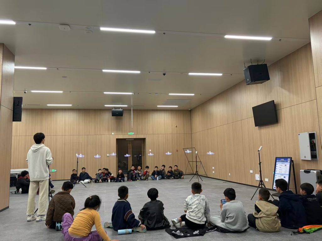
This hands-on drone training and testing under simulated conditions is crucial for building operational confidence and establishing standard operating procedures for foul weather operations.
The market has responded with purpose-built models. According to the “Degrees of Protection Provided by Enclosures (IP Code)” standard, an enclosure protection等级 of IPX5 signifies the ability to withstand water jets from all directions. Leading manufacturers have released drones like the Matrice 350 RTK and the more recent Matrice 4D/4TD, boasting an IP55 rating, indicating dust-protected and protection against low-pressure water jets from any direction. Key technical parameters for a typical weather-resistant inspection drone are summarized below:
| Parameter | Specification |
|---|---|
| Max Takeoff Weight | 2,090 g |
| Max Flight Time (no wind) | 54 min |
| Operating Temperature | -20°C to 50°C |
| Protection Rating | IP55 |
| Max Wind Resistance | 12 m/s |
| Max Ascent Speed | 6 m/s |
| Max Descent Speed | 4 m/s |
| Max Flight Altitude (above sea level) | 6,500 m |
Such drones are capable of stable flight in moderate rain environments and feature reliable data transmission performance, making them suitable for energy inspections, emergency response, public safety, and high-precision professional surveying.
Identifying Critical Zones for Railway Flood Control Drone Patrols
Analyzing domestic railway water damage incidents over the past five years reveals the primary forms of accidents. The data indicates that slope failures and embankment slides constitute a high proportion of incidents, as detailed in the following breakdown:
| Accident Form | Approximate Percentage | Key Characteristics |
|---|---|---|
| Slope Failure / Creep | 44.7% | Most prevalent; involves soil/rock movement on cut or fill slopes. |
| Embankment Slide | 31.6% | Failure of raised earth structures supporting the track. |
| Falling Rocks / Hazardous Rock | 5.3% | Detachment from slopes or cliffs above the line. |
| Other (Drainage, Tunnel, Bridge issues, etc.) | 18.4% | Includes tunnel cracking, bridge pier subsidence, drainage blockage, etc. |
This data directs汛期 patrols to focus on slope conditions, including the integrity of retaining walls and the capacity of drainage facilities. The broader flood control safety context is shaped by factors like increased extreme weather events, complex geography (e.g., mountainous terrain with deep cuttings and high fills), aging or missing infrastructure (e.g., undersized culverts), and damaging human activities (e.g., illegal sand mining near bridges).
Consequently, key segments for targeted drone-based flood control inspection include:
1. Geologically Complex Sections: High-steep slopes and deep cuttings in mountainous railways prone to landslides and debris flows.
2. Critical Drainage Points: Culverts and drainage ditches, especially aged or under-designed facilities.
3. Bridge and Tunnel Vicinity: Bridge piers susceptible to scour, and tunnel portals with poor sealing.
4. Peripheral Toppling Hazards: Masts, billboards, and dangerous trees that may fall onto the track during storms.
5. Historically Vulnerable Locations: Areas with prior damage where recurrence risk is higher.
6. Temporary Construction Zones: Sites where earthworks or terrain alteration may impede drainage.
Drones equipped with专业 sensors can efficiently capture影像 data over these areas, proactively标识 hazard points, and rapidly relay information to management for preventive action.
A Methodological Framework for Selecting Drones Based on Flood Patrol Requirements
To select drone equipment that meets both operational needs and specific weather conditions for different inspection zones (bridges, culverts, perimeter, etc.) under varying rainfall intensities, a comprehensive and scientific evaluation system is essential.
Structuring the Evaluation Index System
Adhering to principles of comprehensiveness, practicality, scientific rigor, and differentiation, a three-tiered index system is constructed from multiple dimensions: Inspection Task (T), Rainfall Environment (E), Personnel Quality (P), and Equipment Performance (D). The hierarchy is as follows:
| Target Layer (A) | Criteria Layer (C) | Indicator Layer (I) – Examples |
|---|---|---|
| Drone Inspection Applicability in Rainfall (A) | Inspection Task (C1) | Terrain Type: Mountain, Plain, Grassland (I11) |
| Structure Focus: Bridge, Culvert, Tunnel, Slope, Embankment (I12) | ||
| Mission Complexity: Area coverage, data resolution required (I13) | ||
| Rainfall Environment (C2) | Rainfall Intensity: Light, Moderate, Heavy (I21) | |
| Wind Speed & Visibility (I22) | ||
| Personnel Quality (C3) | Technical Proficiency / Drone Training Level (I31) | |
| Emergency Drill Performance (I32) | ||
| Continuous Education & Drone Training Status (I33) | ||
| Equipment Maintenance Management Skill (I34) | ||
| Equipment Performance (C4) | Rain Protection Rating (IP) (I41) | |
| System Reliability & Redundancy (I42) | ||
| Endurance & Range (I43) | ||
| Data Transmission Stability in Rain (I44) |
Initial indicators are screened and refined based on expert scoring to eliminate redundancy and prioritize key factors. The “drone training” indicator is emphasized here due to its critical role in safe and effective all-weather operations.
Determining Indicator Weights Using TOPSIS
The Technique for Order Preference by Similarity to an Ideal Solution (TOPSIS) is a robust multi-criteria decision-making method suitable for this evaluation. It ranks alternatives based on their geometric distance from a positive ideal solution (PIS) and a negative ideal solution (NIS). The procedure is as follows:
1. Construct the weighted normalized decision matrix $B$. Let $V = [x_{ij}]_{m \times n}$ be the initial data matrix for $m$ alternatives and $n$ indicators after appropriate normalization (e.g., vector normalization). Let $w_j$ be the weight for indicator $j$, with $\sum_{j=1}^{n} w_j = 1$. Then:
$$b_{ij} = w_j \cdot x_{ij}, \quad B = [b_{ij}]_{m \times n}$$
2. Determine the PIS ($S^+$) and NIS ($S^-$):
$$S^+ = \{ (\max_i b_{ij} | j \in J), (\min_i b_{ij} | j \in J’) \} = \{s_1^+, s_2^+, …, s_n^+\}$$
$$S^- = \{ (\min_i b_{ij} | j \in J), (\max_i b_{ij} | j \in J’) \} = \{s_1^-, s_2^-, …, s_n^-\}$$
where $J$ is the set of benefit indicators (larger is better) and $J’$ is the set of cost indicators (smaller is better).
3. Calculate the separation measures for each alternative $i$ using the Euclidean distance:
$$D_i^+ = \sqrt{\sum_{j=1}^{n} (b_{ij} – s_j^+)^2}, \quad D_i^- = \sqrt{\sum_{j=1}^{n} (b_{ij} – s_j^-)^2}$$
4. Calculate the relative closeness $C_i$ to the ideal solution for each alternative:
$$C_i = \frac{D_i^-}{D_i^+ + D_i^-}, \quad 0 \le C_i \le 1$$
The alternatives (different drone models or configurations) can then be ranked according to $C_i$ values, with a higher $C_i$ indicating better overall suitability for the specified flood patrol task under rainfall conditions. This method provides a quantitative, transparent, and logical basis for selection, effectively balancing the trade-offs between various performance indicators, including crucial soft factors like the level of required drone training.
Analysis of Key Challenges for Railway Inspection Drones
Prevailing Issues
1. Lack of Unified Management Standards: While national regulations and civil aviation rules govern general drone flight activities and operator qualifications, a standardized framework for the systematic and safe application of drones within the railway industry is still nascent. There is a pressing need for top-level industry authorities to formulate unified flight protocols and operational management measures to ensure legality, compliance, safety, and effectiveness across all专业 applications (bridges, earthworks, catenary, etc.).
2. Inadequate Drone Training and Personnel Development: The operator is a critical safety component, responsible for system management, obstacle avoidance, and mission planning. The spatial separation between operator and aircraft poses unique challenges, especially during long-range linear inspections. Deficiencies in systematic theoretical learning and practical simulation演练 often lead to inadequate操控 and delayed emergency response. A robust, tiered drone training regimen is not yet universally implemented.
3. Limitations in Energy Supply: The energy supply unit (battery pack) is a foundational constraint, dictating mission endurance and range. Current batteries face challenges with energy density, limited flight time, and sensitivity to environmental factors like temperature and humidity. Ensuring safe, stable, and long-duration power output for complex railway inspection tasks remains a hurdle, despite ongoing research into new battery chemistries and replenishment methods.
4. Constraints in Environmental Adaptation: Beyond rainfall, missions may encounter high winds, electromagnetic interference, and complex terrains (mountains, forests, gorges) with obstacles and signal blockages. These factors threaten flight stability, data link reliability, and increase collision risks, demanding enhanced onboard intelligence and robust physical design.
Focus on Enhancing Drone Training
The “drone training” deficit warrants a dedicated expansion. A comprehensive program must address several tiers:
| Training Tier | Core Objectives | Key Components |
|---|---|---|
| Basic Operational Proficiency | Ensure safe, competent piloting and mission execution. | Fundamental flight skills via certified courses;机型-specific certification; mandatory minimum logged flight hours before solo operational patrols. |
| Advanced & Emergency Response | Build capability to handle failures and恶劣 weather scenarios. | Scenario-based simulations for loss of link, motor failure, emergency landing in confined areas; specific modules for flying in rain and wind; standardized procedures for incident response. |
| Specialized Role Drone Training | Develop expertise for specific railway inspection roles. | Differentiated training for pilots (flight ops), data analysts (image processing), and maintenance technicians (equipment upkeep). Curriculum tailored to distinct职责. |
| Recurrent & Evaluative | Maintain skills and adapt to new technology/regulations. | Regular proficiency checks; mandatory refresher courses; updates on new software, hardware, and regulatory changes. |
Investing in such structured drone training is paramount to overcoming the “fear of flying” in adverse conditions and ensuring that personnel can reliably “fly well” when it matters most during汛期 emergencies.
Strategic Development Directions
1. Establish Unified Management Frameworks: Railway authorities should develop a systematic drone management architecture, encompassing technical standards, operational procedures, and a strategic fleet allocation plan across departments. This involves aligning with national regulations, evaluating existing grassroots practices, learning from other infrastructure sectors (power, pipelines), and establishing a railway-specific risk early-warning mechanism.
2. Build a Comprehensive Personnel Competency System: As elaborated, this requires strengthening basic operational drone training, perfecting emergency response drills, and implementing specialized role-based development paths to create a professional cadre of operators, technicians, and analysts.
3. Innovate in Power Systems: Explore next-generation energy solutions for extended endurance. This includes hybrid power systems (internal combustion engine + battery with adaptive energy management algorithms) and advanced technologies like hydrogen fuel cells integrated with ducted fans for high-efficiency, long-range patrols.
4. Enhance Systemic Intrinsic Safety: Improve environmental adaptability through robust mechanical design (higher IP ratings), aerodynamic optimization, and upgraded flight control algorithms. Develop active protection mechanisms using AI for intelligent obstacle avoidance, real-time data analysis, and autonomous mission re-planning. Incorporate passive safety features like automatically triggered parachute recovery systems to mitigate risks from catastrophic failures and protect line-side operations.
Conclusion
As drone inspection technology evolves, its application within the railway sector will broaden, particularly for汛期 flood control. This analysis confirms the feasibility of drone flight within certain rainfall parameters, supported by theoretical models, experimental tests, and commercially available weather-resistant platforms. Identifying key risk zones such as slopes, drainage points, and bridge vicinities allows for targeted mission planning. The proposed multi-dimensional evaluation index system, weighted using the TOPSIS methodology, provides a rational framework for selecting drones that best match specific防洪巡检 task requirements under rainy conditions. Crucially, the recurring emphasis on structured drone training throughout the personnel quality indicators and development discussion highlights its role as a cornerstone for safety and efficacy. To fully realize this potential, addressing challenges related to standardized management, comprehensive drone training programs, energy supply, and environmental resilience through the outlined strategic directions is essential. These steps will significantly enhance the safety and effectiveness of deploying inspection drones, especially during critical rainfall events, thereby strengthening the railway network’s overall flood defense capabilities.