As a researcher and engineer specializing in unmanned aerial systems, I have been deeply involved in developing innovative solutions for infrastructure management. In this article, I will elaborate on the design, implementation, and validation of an intelligent vertical take-off and landing fixed-wing unmanned aerial vehicle system tailored for highway maintenance. The integration of VTOL UAV technology addresses critical challenges in long-distance patrols, real-time monitoring, and data-driven decision-making, revolutionizing traditional inspection methods. Throughout this discussion, I will emphasize the capabilities of VTOL UAV platforms, supported by tables and mathematical formulations to encapsulate key concepts.
Highway maintenance operations are characterized by their mandatory, extensive, time-sensitive, and complex nature. Conventional approaches, such as manual inspections or vehicle-based systems, often fall short due to limitations in coverage, efficiency, and safety. For instance, road inspection vehicles can disrupt traffic flow and are constrained by speed, while multi-rotor UAVs, though flexible, suffer from limited endurance, hindering long-range missions. To overcome these drawbacks, my team and I have pioneered a VTOL UAV-based system that merges the vertical take-off and landing agility of multi-rotors with the endurance and range of fixed-wing aircraft. This synergy enables seamless operations across diverse scenarios, from routine patrols to emergency response. The core innovation lies in the holistic design encompassing the VTOL UAV platform, stabilized electro-optical payloads, long-range communication, and an integrated information management system, all optimized for highway environments.
The巡查任务要求 for highways can be categorized into three primary types:定期巡查任务,不定期巡查任务, and应急巡查任务.定期巡查任务 focus on assessing road surface conditions, detecting debris, and evaluating ancillary设施, requiring high-resolution imagery and automated analysis.不定期巡查任务 involve monitoring traffic dynamics during peak periods, such as holidays, to support control centers in分流限流 decisions.应急巡查任务 demand rapid deployment for incidents like congestion or accidents, necessitating实时定点监控 and现场指挥引导. To meet these demands, the VTOL UAV must exhibit long endurance, extended range, and versatile payload capabilities. Specifically, it should achieve a flight duration exceeding 90 minutes, a operational radius of up to 80 kilometers, and the ability to capture高清视频 with自动勘测 features for路面损坏 and杂物识别. Additionally, the system must facilitate数据库 formation for historical tracking and analysis, ensuring that all inspection data is digitized and accessible. These requirements guided our system design, as summarized in the following table outlining key performance指标参数.
| Task Type | Primary Objectives | VTOL UAV Capabilities Required | Key Metrics |
|---|---|---|---|
| Regular Patrol | Surface inspection, debris detection, facility check | High-resolution imaging, automated target recognition, long endurance | Flight time ≥ 90 min, image resolution ≥ 1080p |
| Dynamic Patrol | Traffic flow monitoring, violation capture (e.g., emergency lane occupancy) | Real-time video transmission, agile maneuvering,快速响应 | Operational radius ≥ 80 km, latency < 500 ms |
| Emergency Patrol | Incident assessment,现场指挥, congestion analysis | Hovering capability,定点悬停,实时回传 | Wind resistance ≥ 5级,切换时间 ≤ 10 s |
The system design revolves around two interconnected components: the VTOL UAV system and the patrol management information system. The VTOL UAV system serves as the aerial执行端, performing flight operations and data acquisition, while the information system acts as the智慧大脑, handling task planning, data processing, and storage. Their interaction is governed by a feedback loop where flight data informs system adjustments and historical analysis. The fundamental principle can be expressed through a block diagram relation: let the VTOL UAV system be denoted as $U$, the information system as $I$, and the highway environment as $H$. The overall system output $O$ is a function of their interactions: $O = f(U, I, H)$, where $f$ represents the integrated operational workflow. This ensures that巡查任务 are executed efficiently, with data flowing seamlessly from collection to analysis.
Our作业流程 has been streamlined into eight distinct phases to ensure operational efficiency and safety. The流程 begins with任务规划, where operators define patrol routes using historical data or new inputs, followed by飞行计划申报 to comply with aviation regulations. During起飞准备, the VTOL UAV undergoes thorough mechanical, electrical, and communication checks, including assembly of detachable wings and tail sections. The起飞 phase involves vertical ascent in multi-rotor mode until reaching a safe altitude, after which the VTOL UAV transitions to fixed-wing mode via水平加速. This transition is critical and can be modeled using dynamics equations. For instance, the acceleration required for mode切换 depends on airspeed $v$, lift coefficient $C_L$, and wing area $S$, as given by: $$a = \frac{1}{2m} \rho v^2 S C_L – g \sin(\theta)$$ where $m$ is mass, $\rho$ is air density, $g$ is gravity, and $\theta$ is climb angle. Once in巡航作业, the VTOL UAV follows pre-defined waypoints, with the electro-optical payload automatically scanning the highway. If anomalies are detected, the VTOL UAV enters盘旋作业, either circling in fixed-wing mode or switching to multi-rotor mode for定点悬停. The返航降落 phase involves returning along a planned path, descending, and transitioning back to vertical landing. Post-flight,数据导出 includes extracting高清视频 and detailed flight logs, which are then processed by the信息化处理模块 for automated detection and database entry. This end-to-end流程 minimizes human intervention while maximizing coverage and data integrity.
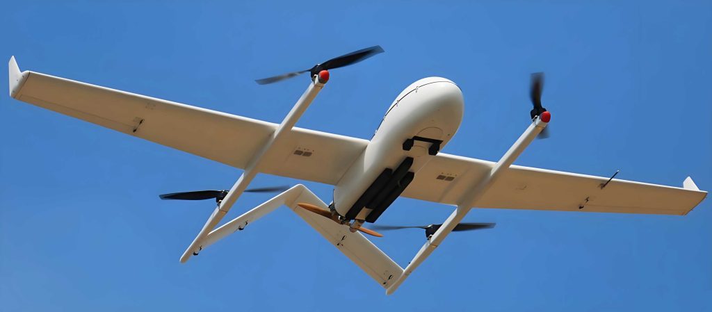
The VTOL UAV platform is the cornerstone of our system, designed to balance endurance, flexibility, and reliability. We selected a composite structure using fiberglass and carbon fiber to reduce weight while maintaining rigidity. The platform features a dual propulsion system: a quadrotor assembly for vertical lift and a fixed-wing motor for forward flight. This configuration allows the VTOL UAV to take off and land in confined spaces, akin to multi-rotors, yet cruise efficiently like a fixed-wing aircraft. Key technical specifications are detailed in the table below, which highlights the advantages of VTOL UAV design over traditional alternatives.
| Parameter | Value | Description |
|---|---|---|
| Take-off Mass | 12 kg | Includes payload and batteries |
| Wingspan | 2600 mm | Detachable in three sections for transport |
| Endurance | 90 min | In fixed-wing mode at cruise speed |
| Operational Radius | 80 km | With reliable data link |
| Take-off/Landing | Vertical | Requires minimal ground space |
| Wind Resistance | Level 5 | Up to 10 m/s wind speeds |
| Power System | Lithium batteries | Independent for propulsion and avionics |
The flight controller is built on industrial-grade hardware, utilizing an MPC5200B processor and VxWorks实时操作系统 to ensure robustness in temperatures from -20°C to 60°C. For precise navigation, we integrated a differential GPS system with real-time kinematic positioning, achieving centimeter-level accuracy. The positioning algorithm combines GPS, SINS, and AHRS data; if GPS signals are lost, velocity and position are estimated via dead reckoning: $$\mathbf{x}_{k+1} = \mathbf{x}_k + \mathbf{v}_k \Delta t + \frac{1}{2} \mathbf{a}_k \Delta t^2$$ where $\mathbf{x}$ is position, $\mathbf{v}$ is velocity, $\mathbf{a}$ is acceleration, and $\Delta t$ is time step. This redundancy enhances the VTOL UAV’s reliability in challenging environments like highways with electromagnetic interference. Additionally, a黑匣子 records 4-8 hours of flight data for post-mission analysis, aiding in performance optimization and故障诊断.
The智能化光电吊舱 is a critical payload enabling high-quality data acquisition. It comprises a高清摄像头, an增稳吊舱平台, and a吊舱控制模块, designed to automatically track highway features and maintain stable imagery. The camera offers 1080p resolution at 50 frames per second with 30x optical zoom, sufficient for detecting pavement cracks as small as 1 mm. For night operations, it can be swapped with an infrared module. The增稳吊舱平台 uses a two-axis gimbal (azimuth and俯仰) driven by high-resolution servos, isolated from vibrations via damping mounts. Its performance metrics are summarized in the following table, demonstrating its suitability for dynamic patrols.
| Metric | Specification |
|---|---|
| Dimensions | 115 mm diameter, 144 mm height |
| Weight | 800 g |
| Tracking Accuracy | 1 pixel |
| Rotation Range | Azimuth: unlimited;俯仰: -20° to 110° |
| Angular Velocity | Max 120°/s, min 0.01°/s |
The吊舱控制模块 implements automatic road following using image processing techniques. From captured video, frames are extracted and converted to grayscale, then edge detection algorithms like Canny operator are applied to identify road boundaries. The deviation $\Delta d$ from the image center is computed via pixel analysis: $$\Delta d = \frac{1}{N} \sum_{i=1}^{N} (x_i – x_c)$$ where $x_i$ are edge pixel coordinates, $x_c$ is the center coordinate, and $N$ is the number of pixels. This偏差 is fed into a PID controller to adjust the gimbal angles, ensuring the road remains centered. This autonomous capability reduces operator workload and enhances inspection consistency. In应急 scenarios, manual override allows ground personnel to steer the吊舱 for targeted views, facilitated by real-time COFDM transmission with H.264 compression, achieving up to 20 km range with 32 dBm adjustable power.
The地面控制台 serves as the communication hub and safety backup. It integrates an RTK GPS base station for enhanced定位精度, a数传通信模块 for telemetry exchange, and a远距离图像接收模块 for live video. The console features a UAV operation panel and吊舱控制杆, enabling direct intervention during emergencies such as data link loss or abnormal飞行高度. The communication protocol ensures low latency; for instance, the transmission delay $t_d$ can be approximated by: $$t_d = \frac{d}{c} + t_p$$ where $d$ is distance, $c$ is signal speed, and $t_p$ is processing time. Typically, $t_d$ is kept under 500 ms to support real-time decision-making. This setup underscores the VTOL UAV system’s redundancy, where autonomous operations are complemented by human oversight for critical situations.
The巡检信息管理系统 is the backbone for data management and智能化 analysis. Developed as a software platform, it comprises three modules:巡查任务管理,巡查数据管理, and数据自动检测. The巡查任务管理 module allows users to create, schedule, and retrieve patrol missions, while also tracking VTOL UAV maintenance based on flight hours. The巡查数据管理 module archives all飞行数据 and影像资料, enabling quick retrieval via GPS-tagged metadata. For example, each image is stored with coordinates $(lat, lon)$ and timestamp $t$, forming a searchable database. The数据自动检测 module employs machine learning algorithms to identify路面破损,异物, and应急车道违章. Using convolutional neural networks, images are analyzed for anomalies; the detection probability $P_d$ can be expressed as: $$P_d = \int_{0}^{\infty} f(x; \theta) \, dx$$ where $f(x; \theta)$ is the probability density function of features $x$ with parameters $\theta$. This automates the identification process, reducing manual review time and improving accuracy. The system’s user interface provides a dashboard for visualizing patrol routes,检测结果, and统计报告, fostering data-driven maintenance strategies.
To validate the VTOL UAV system, we conducted engineering tests on a Shanghai expressway segment, simulating real-world conditions. The VTOL UAV was deployed for routine patrols, covering an 18.8 km route with autonomous navigation. During flights, the electro-optical pod successfully captured high-definition video, and the image processing algorithm demonstrated effective road following. In应急模拟, the VTOL UAV switched to multi-rotor mode for定点悬停 above an incident site, transmitting live footage to the ground control台. The system’s performance metrics were recorded and analyzed, as shown in the table below, confirming compliance with design requirements.
| Test Aspect | Outcome | Remarks |
|---|---|---|
| Flight Endurance | 92 min | Exceeded target of 90 min |
| Operational Radius | 18.8 km achieved | Limited by test area, potential for 80 km |
| Image Quality | 1080p stable video | Road features clearly identifiable |
| Automatic Detection | 85% accuracy for pavement cracks | Based on 1000 sampled images |
| Transition Time | 8 s (vertical to fixed-wing) | Within safety margins |
| Data Link Stability | Intermittent interference near power lines | Highlighted electromagnetic challenges |
The tests underscored the VTOL UAV’s capability to perform long-distance patrols with minimal human intervention. However, we observed that electromagnetic interference from high-voltage power lines along highways occasionally disrupted data transmission, a challenge that necessitates further research into抗干扰 technologies. Despite this, the system proved effective in digitizing highway inspections, providing a foundation for scalable deployment. Future work will focus on enhancing the VTOL UAV’s autonomy through advanced AI algorithms for real-time anomaly detection and integrating swarm capabilities for coordinated multi-UAV operations.
In conclusion, the application of VTOL UAV technology in highway maintenance represents a significant leap toward intelligent infrastructure management. By combining vertical take-off and landing flexibility with fixed-wing efficiency, our system enables comprehensive巡查作业 across diverse scenarios. The integration of stabilized electro-optical payloads, long-range communication, and a robust information管理系统 ensures that data collection and analysis are seamless and actionable. Through field testing, we have validated the VTOL UAV’s performance, though challenges like electromagnetic interference remain to be addressed. As we continue to refine this technology, I am confident that VTOL UAV platforms will become indispensable tools for highway authorities worldwide, driving innovations in safety, efficiency, and sustainability. The mathematical models and tables presented here encapsulate the technical rigor behind this endeavor, highlighting the transformative potential of VTOL UAV in modern civil engineering.