From my vantage point within the rapidly evolving field of precision agriculture, the strategic development of drone training programs represents a critical nexus between technological innovation and practical farming needs. The collaboration between academic institutions and technology enterprises to cultivate a new generation of skilled operators, or “pilots,” is not merely an educational trend but a fundamental shift in agricultural methodology. This synthesis of theory and hands-on practice is essential for unlocking the full potential of unmanned aerial systems in modern farming.
The core model of this educational advancement is the establishment of integrated production-teaching-research bases. These bases function as “schools within factories,” where trainees immerse themselves in the complete lifecycle of agricultural drones—from research and development to assembly, system diagnostics, and field deployment. This immersive approach moves beyond textbook learning, fostering a deep, intuitive understanding of the technology’s mechanics and capabilities. A structured drone training curriculum typically encompasses several interconnected modules, as outlined below:
| Training Module | Theoretical Components | Practical Components | Learning Outcome |
|---|---|---|---|
| Platform Fundamentals | Aerodynamics, UAV Components, Battery & Power Systems, Regulations & Safety | Assembly/Disassembly, Pre-flight Checks, Basic Piloting, Maintenance | Comprehensive understanding of drone hardware and operational protocols. |
| Mission Planning & Operations | Flight Physics, GPS & GNSS Principles, Weather Impact, Airspace Management | Software-Based Route Planning, Autonomous Flight Execution, Emergency Procedures | Ability to plan and execute safe, efficient, and compliant flight missions. |
| Precision Application | Agronomy Basics, Pest/Disease Identification, Chemical Properties, Nozzle Technology | Spray System Calibration, Swath Adjustment, Variable Rate Application Trials | Skills to apply inputs (pesticides, fertilizers) with high spatial precision. |
| Data Acquisition & Analysis | Spectral Signatures, Sensor Types (RGB, Multispectral, Thermal), Data Formats | Sensor Operation, Mission Planning for Mapping, Processing Raw Data into Maps (NDVI, etc.) | Competence in collecting and interpreting aerial data for crop health insights. |
The quantitative benefits driving the demand for such drone training are profound. Compared to traditional tractor-mounted or manual sprayers, drone-enabled precision application demonstrates superior efficiency and resource optimization. The key metrics can be modeled mathematically. For instance, the effective coverage rate $C_{eff}$ of a drone sprayer, considering factors like swath width, speed, and operational efficiency, can be expressed as:
$$
C_{eff} = (W_s \cdot V \cdot \eta \cdot T) / A_{field}
$$
Where $W_s$ is the effective swath width (m), $V$ is the operational speed (m/s), $\eta$ is the operational efficiency factor (accounting for turn-around time, refilling), $T$ is total operation time (s), and $A_{field}$ is the total field area (m²). More importantly, the reduction in chemical usage $R_{chem}$ due to targeted application is a major economic and environmental driver, calculable as:
$$
R_{chem} = 1 – \frac{Q_{drone}}{Q_{trad}}
$$
Here, $Q_{drone}$ and $Q_{trad}$ represent the volume of chemical applied per hectare by drone and traditional methods, respectively. Field practices consistently show $R_{chem}$ values between 0.2 and 0.5, indicating 20-50% savings. The operational advantage is summarized in the following comparative analysis:
| Performance Metric | Traditional Mechanized Spraying | Drone-Based Precision Spraying | Relative Advantage |
|---|---|---|---|
| Application Rate (L/ha) | 300 – 500 | 15 – 30 | ~90% Reduction |
| Water Usage (L/ha) | 300 – 500+ | 15 – 30 | ~90% Reduction |
| Field Coverage Speed (ha/hr) | 2 – 4 | 6 – 10 | 2x – 3x Faster |
| Uniformity & Penetration | Variable; often poor under canopy | High; downwash effect improves penetration | Significantly Improved |
| Soil Compaction & Crop Damage | High (from machinery traffic) | None | Eliminated |
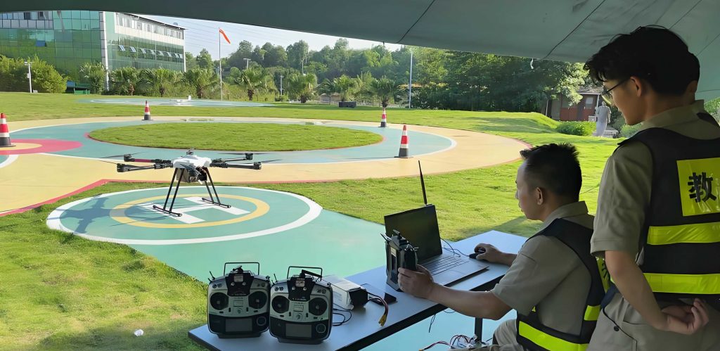
The image above captures the essence of modern drone training: a dedicated outdoor facility where theory meets the reality of the field. It is in such environments that trainees transition from simulated exercises to managing actual flight missions over crops, dealing with real-world variables like wind, terrain, and equipment response. The establishment of these dedicated training grounds, often in partnership with local farms, provides the perfect ecosystem for iterative learning and immediate application of skills. Scaling a program to reliably certify hundreds of new pilots annually, as targeted by leading initiatives, requires this blend of structured curriculum and authentic field experience. The economic model for such training and service provision becomes compelling. For a typical service operation, the annual potential revenue $R_{annual}$ can be estimated based on serviceable area, pricing, and fleet utilization:
$$
R_{annual} = N_{drone} \cdot U_{drone} \cdot A_{rate} \cdot P_{service}
$$
In this model, $N_{drone}$ is the number of operational drones, $U_{drone}$ is the annual utilization rate per drone (in hectares), $A_{rate}$ is the average number of applications per season, and $P_{service}$ is the price per hectare per application. A well-trained pilot can manage multiple drones, optimizing this equation significantly.
Looking forward, the scope of drone training is poised for significant expansion beyond basic piloting and spraying. The future lies in integrating data science with aerial robotics. The next-generation curriculum will delve into advanced areas such as multispectral and thermal data collection for early stress detection, automated anomaly identification using machine learning algorithms, and the integration of drone-collected data into farm management software for decision support. The potential extends into the entire agricultural value chain, including aspects like yield prediction modeling and quality assurance tracing. For example, correlating vegetation index data from key growth stages with final yield allows for predictive modeling:
$$
Y_{pred} = \alpha + \beta_1 \cdot NDVI_{stage1} + \beta_2 \cdot NDVI_{stage2} + … + \epsilon
$$
Where $Y_{pred}$ is the predicted yield, $\alpha$ is the intercept, $\beta_i$ are coefficients for the Normalized Difference Vegetation Index (NDVI) values at different crop growth stages, and $\epsilon$ is the error term. Training operators to understand and execute missions for collecting this data transforms them from pilots into true agricultural technologists.
In conclusion, the systematic development of comprehensive drone training programs is a cornerstone for the sustainable intensification of agriculture. It addresses the critical need for skilled human capital capable of bridging the gap between sophisticated technology and ground-level farming challenges. By combining rigorous technical education with extensive field practice within collaborative industry-academic frameworks, these programs do more than create pilots; they cultivate innovators and problem-solvers. The measurable improvements in input efficiency, operational productivity, and data-driven decision-making underscore the transformative return on investment in such education. As the technology continues to advance, so too must the depth and breadth of drone training, ensuring the agricultural sector is equipped to harness these powerful tools for enhanced productivity, sustainability, and resilience. The journey from a novice to a proficient agricultural drone specialist is a multifaceted one, blending mechanics, agronomy, data analysis, and entrepreneurial acumen—a journey that is fundamentally reshaping the future of farming.