In recent years, the rapid development of national economic construction has imposed stricter requirements on the accuracy of geospatial data across various fields. Traditional aerial surveying methods primarily rely on manned aircraft, which are significantly influenced by weather and environmental factors. Additionally, these methods require avoiding complex and high-risk routes to ensure pilot safety, along with limitations on flight altitude and speed, leading to substantial deviations between survey results and actual needs. Multirotor drone remote sensing systems, as low-altitude flying remote sensing platforms, offer advantages such as high real-time performance, strong anti-disturbance capability, and low manufacturing costs, effectively compensating for the shortcomings of traditional aerial surveying. By equipping multirotor drones with cameras and sensor devices, remote sensing tasks in complex and hazardous areas can be efficiently completed, obtaining high-precision remote sensing images. This provides foundational data and decision support for fields like agricultural monitoring, road site selection, and resource exploration. Furthermore, multirotor drones do not require pilots, making them highly applicable in military reconnaissance and disaster emergency monitoring. Therefore, designing a remote sensing system for multirotor drones has become a key focus in various sectors.
Numerous design achievements exist for such systems; for instance, some researchers have utilized plugin technology and visual attention mechanisms for system design. These systems can achieve high precision in controlling the position and attitude of drones, but the multirotor drones struggle to pass through narrow areas, and the acquired remote sensing images exhibit significant distortion. Remote control technology, which involves operating remote devices via networks, is highly suitable for ground personnel to monitor multirotor drones in real-time remotely. Thus, this paper designs a remote sensing system for multirotor drones based on remote control technology.
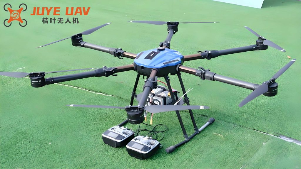
The remote sensing system for multirotor drones based on remote control technology consists of four subsystems: the unmanned aerial vehicle, task payload, remote control, and ground support. The specific structure is as follows. The task payload subsystem includes high-resolution digital cameras, attitude sensors, and GPS locators. Using multirotor drones equipped with various devices, it collects the necessary data resources in real-time. High-resolution digital cameras capture images of the flight environment of the multirotor drone. Attitude and ultrasonic sensors measure the attitude data and relative height data of the multirotor drone, respectively. The GPS locator is used to measure the flight position data of the multirotor drone. The ground support subsystem includes modules such as a monitoring computer, radio remote controller, and data transmission radio. The data transmission radio module promptly transmits the data collected by the task payload subsystem to the monitoring computer. Ground monitoring personnel can view the received data in real-time through the monitoring computer, comprehensively grasping the position, flight path, and operational status of the multirotor drone. Simultaneously, they can issue remote sensing commands to the remote control subsystem via the monitoring computer. The radio remote controller is primarily used to control operations such as takeoff, landing, and emergency procedures of the drone. The data processing module is responsible for persistently storing various types of data received by this subsystem, ensuring that ground personnel can review historical data.
The remote control subsystem mainly consists of a control platform, communication module, and receiver. When the receiver receives remote sensing commands from the ground support subsystem, the communication module transmits the stored data, such as flight environment images, attitude, and height of the multirotor drone, to the unmanned aerial vehicle subsystem. Additionally, the communication module can feedback data generated by this subsystem to the ground support subsystem. The control platform drives various modules in the unmanned aerial vehicle subsystem to perform corresponding functions and controls the drone to complete remote sensing tasks according to given requirements. The unmanned aerial vehicle subsystem is the core of the entire remote sensing system, including modules such as the flight platform, trajectory planning, and remote sensing image acquisition. The flight platform is the selected multirotor drone, which offers advantages like long endurance, stable flight, and high operational efficiency. When this subsystem receives control commands from the remote control subsystem, the trajectory planning module uses the transmitted flight environment images of the multirotor drone and applies a multirotor drone trajectory planning method based on the wolf pack algorithm to derive the optimal trajectory for the multirotor drone during remote sensing tasks. Based on this, following the workflow of the remote sensing image acquisition module and combining attitude and height data of the multirotor drone, the control platform of the remote control subsystem controls the multirotor drone to complete the remote sensing image acquisition task according to the planned trajectory. After acquiring remote sensing images, the remote sensing image processing module performs geometric distortion correction, image enhancement, and image stitching to obtain complete, high-quality remote sensing images.
The sensor structure responsible for collecting attitude and relative height data of the multirotor drone is designed as follows. The sensor interface directly measures the attitude and relative height of the multirotor drone, with the measurement results being analog signals. These are transmitted to the signal conditioning circuit for amplification and filtering to eliminate noise in the analog signal, then output to the data acquisition card. This unit processes the denoised analog signal through sampling, quantization, and encoding, converting it into digital signals recognizable by the microprocessor, thus achieving digital signal integration. The bus communication interface connects the sensor to the data transmission radio in the ground support subsystem, enabling the transmission of integrated digital signals between them. The power management and reset unit provides energy to the sensor and performs reset functions. The display circuit presents the operational status and relevant data of the sensor.
The structure of the remote control subsystem responsible for remote control of multirotor drone remote sensing is designed as follows. The control platform of the remote control subsystem selects the Samsung S3C2440 microprocessor with an ARM920T kernel, which offers advantages such as low power consumption, high cost-effectiveness, and rich peripheral interfaces. The GPRS/GSM communication module selects the dual-band supported TC35i, with a serial port rate reaching 1250 bps to 116300 bps, meeting the large data transmission and real-time requirements of the multirotor drone remote sensing system. Serial communication is the main form of data interaction and control between the control platform and peripherals such as the flight platform and system modules. The address bus, data bus, and control bus are all connected to the control platform, while the I/O bus is connected to various peripherals, with communication control of each bus managed by the serial bus controller. Before serial communication, the serial interface UART must be enabled, and after completing its initial configuration, data transmission and control can proceed.
To improve the remote sensing accuracy of multirotor drones, the remote sensing image acquisition process must be strictly followed. Based on the requirements of the remote sensing project, fully collect and organize relevant data of the study area, such as geographical location, engineering geology, and survey area scope. Use the aerial network point placement method to set image control points to avoid the impact of electromagnetic interference on the flight position of the multirotor drone. Simultaneously, use the RTK real-time kinematic method to measure each image control point, obtaining corresponding coordinates and marker point numbers. According to the aerial survey range of the multirotor drone remote sensing, set parameters such as the high-resolution digital camera parameters, ground resolution, and flight height of the multirotor drone. Use the multirotor drone trajectory planning method based on the wolf pack algorithm to plan the ideal trajectory, adjust the trajectory through field investigation, and save it after adjustment. Upon arriving at the remote sensing task area, use an anemometer to test the wind speed. If it is below level 5, assemble the multirotor drone and check whether components such as the battery, circuits, and magnetic compass meet the specified standards. After ensuring everything is correct, import the planned trajectory, and use the control platform of the remote control subsystem to control the multirotor drone to fly according to the planned trajectory. During its flight, ground monitoring personnel need to pay real-time attention to data such as the position, speed, and attitude of the multirotor drone through the monitoring computer to ensure the smooth completion of the remote sensing task. Check the quality of the obtained remote sensing images from aspects such as missing shots, color, and noise. If the quality standards are met, save the remote sensing images and proceed with image processing; otherwise, re-shoot.
During flight, multirotor drones are susceptible to various threats such as radar and terrain. Therefore, the threat equivalent terrain simulation method can be used to simulate all threats as mountain terrain and mark their positions and action ranges on the digital map, obtaining comprehensive terrain information to simplify the multirotor drone trajectory planning problem. Based on this method, the mathematical model of threat equivalent terrain can be obtained as:
$$z(x,y) = h_0 + \sum_{j=1}^{N} h_{\text{max}_j} \cdot \exp\left[ -k_{x_j} \cdot \left( \frac{x – x_{\text{max}_j}}{x_{\text{max}_j}} \right)^2 – k_{y_j} \cdot \left( \frac{y – y_{\text{max}_j}}{y_{\text{max}_j}} \right)^2 \right]$$
where the number of equivalent peaks is described by N; the baseline terrain height is described by $h_0$; the height of the peak vertex of order j is described by $h_{\text{max}_j}$, where j ranges between 1 and N; the horizontal and vertical coordinates of this peak vertex are described by $x_{\text{max}_j}$ and $y_{\text{max}_j}$, respectively; the slope measures along the x and y directions of this peak are described by $k_{x_j}$ and $k_{y_j}$, respectively; the horizontal coordinate of a point on the horizontal projection plane is described by x, the vertical coordinate by y, and the terrain height at this coordinate point by z.
By setting the parameter values of the above mathematical model, a simulation diagram of the threat equivalent terrain can be obtained. Assuming the start and end points of the multirotor drone trajectory are described by $P_s$ and $P_f$, respectively, the line between the two points along the x-direction is divided into n+1 segments, the division points are described by $x_i$, and the corresponding trajectory points are described by $P_i$, with coordinates $(x_i, y_i, z_i)$. These trajectory points must satisfy the conditions of being non-obstacle points and the line connecting them to the preceding and following trajectory points not passing through obstacles. Then, the target fitness function of the multirotor drone can be obtained as:
$$F = \sum_{i=1}^{n+1} \left( \omega_1 l_i + \omega_2 f_i \right)$$
where the cost function of the multirotor drone trajectory is described by F; the length and threat index of the i-th trajectory segment are described by $l_i$ and $f_i$, respectively; their corresponding weights are described by $\omega_1$ and $\omega_2$, used to determine whether to bypass the peaks.
Set $h_{\text{best}_i}$ to represent the optimal ground clearance height of the multirotor drone. If the multirotor drone flies according to $h_{\text{best}_i}$, the threat index of this trajectory segment is minimized. Therefore, using height as a penalty term, the above function is transformed into the following form to obtain the shortest multirotor drone trajectory while ensuring safe flight of the multirotor drone.
$$F = \sum_{i=1}^{n+1} \left( \sqrt{(x_i – x_{i-1})^2 + (y_i – y_{i-1})^2 + (z_i – z_{i-1})^2} + \omega_h (z_i – h_{\text{best}_i})^2 \right)$$
Inside the formula, the coordinates of $P_s$ of the multirotor drone trajectory are described by $(x_0, y_0, z_0)$, and the coordinates of $P_f$ are described by $(x_{n+1}, y_{n+1}, z_{n+1})$. If the value of i ranges between 1 and n, then $h_{\text{best}_i} = z(x_i, y_i) + \Delta h$, where the minimum flight height of the multirotor drone is described by $\Delta h$, and $z(x_i, y_i)$ can be obtained using the first formula.
The following is the specific process of using the wolf pack algorithm to solve the target fitness function and obtain the multirotor drone trajectory. First, set the start and end points of the multirotor drone, and randomly select N trajectories between them as gray wolves. Simultaneously, set parameters such as the proportional factor a, step factor C, and iteration count limit $K_{\text{max}}$ for the gray wolves. Second, calculate the fitness value of each gray wolf, where the gray wolf corresponding to the maximum value is the head wolf, and the remaining wolves are scout wolves, performing wandering behavior and continuously updating their own positions. When the fitness value of a scout wolf i exceeds that of the head wolf, or the wandering count limit $T_{\text{max}}$ is reached, proceed to the third process. Third, perform summoning behavior. If the fitness value of a fierce wolf j during its rush towards the prey exceeds that of the head wolf, use this wolf to replace the head wolf and initiate a summon; otherwise, this wolf continues its rush. If the distance between this wolf and the head wolf is smaller than the judgment distance, proceed to the fourth process. Fourth, perform besieging behavior. Besiege using the head wolf’s position as the prey position, and continuously update the positions $x_{id}$ of the gray wolves participating in the besieging. If $x_{id}$ is not an obstacle point and the line connecting it to the preceding and following points does not pass through obstacles, use this position as the head wolf’s position. Fifth, if the iteration count reaches $K_{\text{max}}$, output the head wolf’s position, i.e., the planned optimal trajectory of the multirotor drone; otherwise, jump to the second process.
We selected a mountainous area as the remote sensing area for the multirotor drone. This area has higher terrain in the west and lower in the east, with significant undulations and complex topography, including landforms such as hills, river valley terraces, and isolated peak plains. Using this system, we collected environmental image data of the area and planned the multirotor drone trajectory based on it, thereby controlling the multirotor drone to complete the remote sensing task of the area according to the planned trajectory.
We selected two multirotor drones for testing, and the roll angle response curves of the two are shown in the results. Additionally, we selected 10 test points in the remote sensing area and used this system to control the multirotor drone to fly to each test point, comparing the actual arrival positions of the two with the test point positions. The results are shown in the table below.
| Test Point ID | Control Distance (m) | Test Point Coordinates (x, y) | Arrival Coordinates (x, y) – Drone A | Arrival Coordinates (x, y) – Drone B |
|---|---|---|---|---|
| A1 | 200 | (263, 189) | (262, 189) | (263, 189) |
| A2 | 400 | (314, 217) | (314, 217) | (314, 217) |
| A3 | 600 | (136, 259) | (136, 258) | (136, 259) |
| A4 | 800 | (326, 331) | (326, 331) | (326, 330) |
| A5 | 1000 | (128, 345) | (128, 345) | (128, 345) |
| A6 | 1200 | (348, 489) | (348, 489) | (348, 489) |
| A7 | 1400 | (396, 428) | (394, 427) | (396, 428) |
| A8 | 1600 | (503, 427) | (503, 427) | (503, 427) |
| A9 | 1800 | (295, 473) | (295, 473) | (295, 475) |
| A10 | 2000 | (366, 521) | (366, 521) | (366, 521) |
From the analysis of the roll angle response curves, it can be observed that the current roll angle curves of the two multirotor drones basically coincide with the expected roll angle curves, indicating that the multirotor drones have a stable response effect to control commands. From the table, it can be seen that the actual positions of the two multirotor drones arriving at the test points are basically the same as the target positions, and are not affected by the control distance. Therefore, it can be concluded that this system has ideal remote control capability for both the attitude and position of the multirotor drone.
We selected a sub-area of 200 km × 200 km from the study area for trajectory planning. Scenario 1: Only one multirotor drone to be planned exists in the sub-area, with 5 static obstacles and 2 threat zones set, and 6 test points calibrated. Scenario 2: In addition to the multirotor drone to be planned, there are 3 flying multirotor drones in the sub-area, with 4 static obstacles, 1 threat zone, and 5 test points set. For these two complex scenarios, the multirotor drone trajectories planned by this system are shown in the results.
From the analysis of the trajectory planning test results, it can be seen that in the above two complex scenarios, the multirotor drone trajectories planned by this system can effectively avoid all static obstacles and threat zones, and can maintain a certain safe distance from other flying multirotor drones. Additionally, the planned trajectories can pass through all test points. Therefore, it shows that this system has excellent multirotor drone trajectory planning effects, with good obstacle avoidance capability and test point coverage.
We selected remote sensing images of a certain area for stitching, with specific results as shown. From the results, it can be seen that the remote sensing images obtained by this system have good resolution. After stitching processing, the resulting images have high quality and completeness. Therefore, it shows that the multirotor drone remote sensing capability of this system is strong, enabling high-precision acquisition of remote sensing images, and the image stitching effect has obvious advantages.
In conclusion, with remote control technology as the core, through the mutual cooperation of the four subsystems of ground support, task payload, remote control, and unmanned aerial vehicle, the design of the multirotor drone remote sensing system is completed. This system can effectively control the attitude and position of the multirotor drone using remote control technology. Moreover, the multirotor drone trajectory planned by this method has good obstacle avoidance effects for both static and dynamic obstacles and can comprehensively cover specified test points. Additionally, this method enables high-precision acquisition and high-quality stitching of remote sensing images.
The application of multirotor drones in remote sensing systems has revolutionized data collection in various fields. The integration of advanced sensors and communication modules ensures real-time data transmission and processing. The use of optimization algorithms like the wolf pack algorithm enhances the efficiency and safety of multirotor drone operations. Future work may focus on improving the autonomy of multirotor drones and integrating artificial intelligence for better decision-making. The continuous development of multirotor drone technology will further expand its applications in environmental monitoring, disaster management, and urban planning. The reliability and versatility of multirotor drones make them indispensable tools in modern remote sensing. Ensuring the security and robustness of the remote control system is crucial for the widespread adoption of multirotor drone-based solutions. Collaborative efforts between researchers and industry professionals will drive innovations in multirotor drone design and functionality. The potential of multirotor drones to transform geospatial data acquisition is immense, and ongoing research will unlock new possibilities. The combination of multirotor drones with emerging technologies like 5G and IoT will create more integrated and intelligent remote sensing systems. The scalability of multirotor drone systems allows for customization based on specific project requirements. The cost-effectiveness of multirotor drones compared to traditional methods makes them accessible for various applications. The environmental benefits of using multirotor drones include reduced carbon footprint and minimal disturbance to ecosystems. The accuracy and resolution of data collected by multirotor drones are superior to many conventional techniques. The adaptability of multirotor drones to different terrains and conditions underscores their utility in diverse scenarios. The implementation of multirotor drone systems requires careful planning and adherence to regulatory standards. The training of personnel for operating multirotor drones is essential for maximizing their potential. The maintenance and upkeep of multirotor drone equipment ensure long-term performance and reliability. The data management strategies for handling large volumes of information from multirotor drones are critical for effective analysis. The collaboration between multirotor drone systems and other remote sensing platforms can provide comprehensive coverage. The ethical considerations of using multirotor drones, such as privacy and safety, must be addressed. The global adoption of multirotor drone technology is accelerating, with numerous success stories across sectors. The future of multirotor drones in remote sensing looks promising, with continuous advancements on the horizon.