In recent years, the proliferation of small unmanned aerial vehicles (UAVs) has presented significant challenges to low-altitude security. These devices are inexpensive, easily accessible, and highly maneuverable, making them potential tools for malicious activities such as smuggling, espionage, or even terrorist attacks. As a designer and engineer focused on multi-sensor collaborative detection and early warning systems, I have been involved in developing an integrated anti-UAV system tailored for protecting critical areas like government facilities, nuclear power plants, and large public events. This anti-UAV system leverages heterogeneous sensors—including radar, electro-optical infrared (EO/IR), and radio frequency (RF) detection—to achieve early detection, continuous tracking, accurate identification, and effective countermeasures against small UAVs. In this article, I will detail the design and implementation of this anti-UAV system, emphasizing key technologies such as multi-sensor data fusion and collaborative detection. The goal is to provide a robust solution that enhances situational awareness and response capabilities in complex environments.
The core motivation behind this anti-UAV system stems from the limitations of existing approaches. Traditional methods, such as geo-fencing or UAV registration, rely on cooperative measures and can be circumvented by modified or rogue drones. Therefore, our anti-UAV system adopts a non-cooperative stance, integrating active and passive sensors to detect, track, and neutralize threats independently. From my perspective, the system’s effectiveness hinges on seamless integration of diverse sensors, each with unique strengths and weaknesses. For instance, radar offers all-weather, long-range detection but lacks target identification, while EO/IR provides high-resolution imagery for visual confirmation but is limited by weather conditions and field of view. By fusing data from these sensors, we can create a comprehensive picture of the airspace, enabling timely and informed decisions.
To illustrate the system’s practical deployment, consider its application during major public events or at sensitive infrastructure sites. In such scenarios, the anti-UAV system must operate autonomously, with minimal human intervention, to detect intrusions and initiate countermeasures. Our design prioritizes scalability and adaptability, allowing it to be configured for various terrains and threat profiles. Throughout this article, I will share insights from hands-on experience, including challenges faced during testing and optimization phases. The following sections will delve into the system composition, architectural design, working principles, and critical algorithms, supported by tables and mathematical formulations to clarify technical aspects.
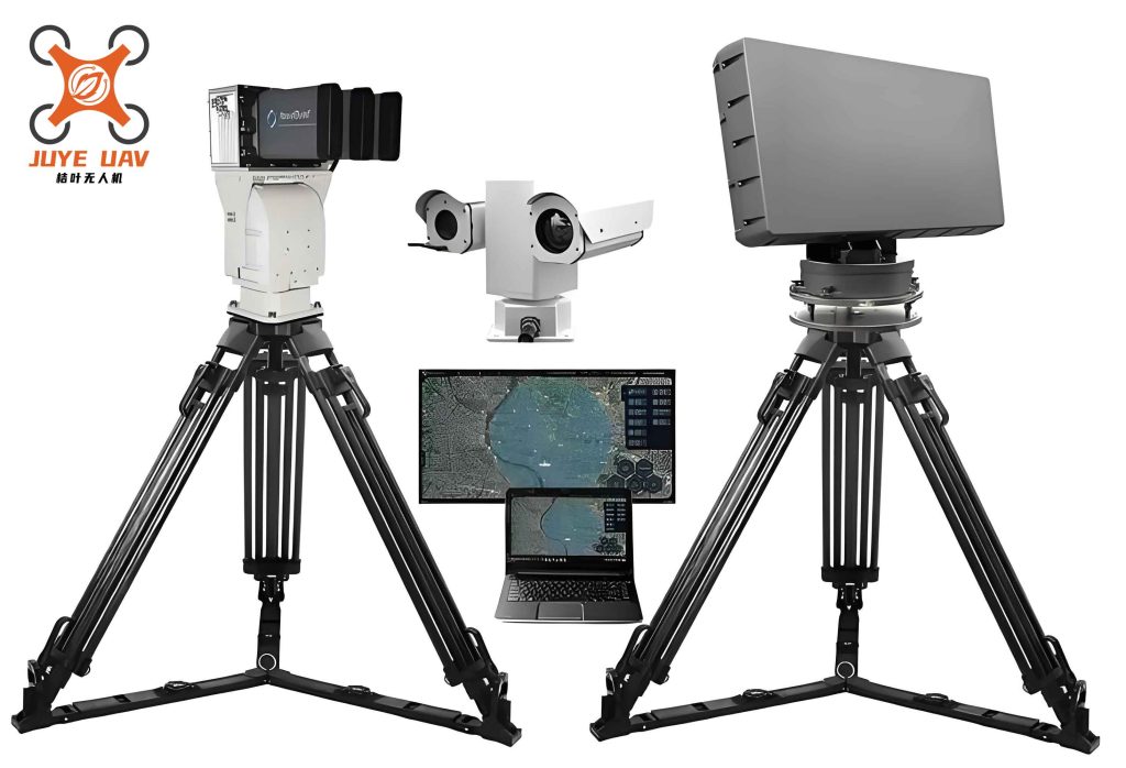
The anti-UAV system comprises five main subsystems: the Intelligent Management and Control Subsystem, Radar Detection Subsystem, EO/IR Tracking Subsystem, RF Detection Subsystem, and Interference Countermeasure Subsystem. Each plays a vital role in the overall functionality, and their interoperability is crucial for success. As the lead engineer, I oversaw the integration of these components, ensuring that data flows smoothly and commands are executed reliably. Below, I describe each subsystem in detail, highlighting their specifications and contributions to the anti-UAV mission.
The Intelligent Management and Control Subsystem serves as the brain of the anti-UAV system. It is responsible for aggregating data from all sensors, performing fusion processing, generating composite tracks, and displaying situational awareness on a Geographic Information System (GIS) interface. From my workstation, I can monitor real-time airspace conditions, track UAV movements, and oversee device statuses. This subsystem also handles alarm triggering based on predefined rules, such as when a UAV enters a restricted zone. Its software architecture is built on a client-server model, which facilitates distributed deployment and remote management. Key features include a user-friendly dashboard that overlays radar tracks, EO/IR video feeds, and RF alerts, enabling operators to make rapid decisions. During field tests, we refined the algorithms to reduce false alarms, particularly from birds or other clutter, which are common in urban environments.
The Radar Detection Subsystem employs a two-dimensional phased-array circular radar capable of scanning 360 degrees. Compared to mechanical scanning radars, this design offers higher data rates—up to 0.2 seconds per update—which is essential for tracking small, agile UAVs. The radar provides three-dimensional coordinates (range, azimuth, and elevation) with accuracies of ≤1° in azimuth and ≤2° in elevation (above 7°). These metrics are critical for guiding other sensors, such as the EO/IR system, to acquire targets. In our anti-UAV configuration, the radar operates in both search and track modes, prioritizing sectors indicated by RF detection inputs. One challenge we encountered was the radar’s sensitivity to low-radar-cross-section targets; however, through waveform optimization and adaptive signal processing, we improved detection probabilities for drones as small as 0.01 m². The radar’s output is continuously fed into the fusion engine, where it is correlated with other sensor data to form stable tracks.
The EO/IR Tracking Subsystem consists of high-resolution cameras and infrared sensors mounted on a pan-tilt unit. It offers precise angular measurements (azimuth and elevation) and visual identification capabilities, but its field of view is narrow—approximately 1° in azimuth and 0.8° in elevation. Therefore, it relies on radar cues to slew onto targets. Once locked, the EO/IR subsystem can track UAVs with high accuracy, providing video evidence for threat assessment. From my experience, this subsystem is invaluable in daylight or clear weather, but its performance degrades in fog or heavy rain. To mitigate this, we integrated multiple EO/IR units at different locations, creating a redundant network. The subsystem’s output includes both video streams and angular data, which are used to refine composite tracks and support forensic analysis post-engagement.
The RF Detection Subsystem passively monitors electromagnetic spectra to identify UAV control signals, video transmission links, and GPS frequencies. It can detect UAVs as soon as they are powered on, often before radar acquisition, making it a key early-warning component. The subsystem provides azimuth information from single stations or geolocation from dual-station cross-bearing. Additionally, it can fingerprint specific UAV models based on signal characteristics, adding a layer of identification. However, in crowded RF environments, false alarms can occur due to interference from Wi-Fi or other wireless devices. We addressed this by implementing machine learning classifiers that distinguish UAV signals from background noise. The RF data is fused with radar and EO/IR inputs to enhance track confidence and reduce latency in threat declaration.
The Interference Countermeasure Subsystem deploys jamming techniques to disrupt UAV operations. It emits tailored RF signals that overpower the drone’s command, video, and GPS links, forcing it to land, return to its operator, or enter a failsafe mode. The jamming parameters are dynamically adjusted based on target type and range, guided by tracks from the fusion system. During live exercises, we found that a combination of GPS spoofing and command signal suppression is most effective against commercial drones. This subsystem is integrated into the overall command chain, allowing automatic or manual activation based on threat levels. Safety considerations are paramount, as jamming must not affect legitimate communications; thus, we use directional antennas and frequency-hopping protocols to minimize collateral impact.
The overall architecture of the anti-UAV system follows a layered approach, encompassing hardware platforms, data layers, service layers, and application layers. This modular design facilitates upgrades and customization for different mission profiles. From my design perspective, the architecture ensures scalability, allowing additional sensors or countermeasures to be incorporated seamlessly. The data layer manages track data, geographic data, and baseline data (e.g., alarm rules and UAV signature libraries). The service layer provides core functions like data ingestion, fusion processing, and geographic rendering, while the application layer delivers user interfaces for visualization, command and control, and post-mission analysis. Below is a table summarizing the key specifications of each sensor subsystem, which I used during system calibration and performance evaluation.
| Subsystem | Primary Function | Detection Range | Accuracy | Data Rate | Limitations |
|---|---|---|---|---|---|
| Radar Detection | 3D tracking | Up to 10 km | Az: ≤1°, El: ≤2° | 0.2 s | Clutter, blind zones |
| EO/IR Tracking | Visual ID, 2D angles | Up to 5 km (day) | Az: 0.01°, El: 0.01° | 30 Hz (video) | Weather-dependent |
| RF Detection | Signal interception | Up to 15 km | Az: 2° (single station) | 1 s | RF interference |
| Interference | Jamming | Up to 3 km | N/A | Instantaneous | Collateral effects |
The workflow of the anti-UAV system involves two parallel streams: multi-source information processing and intelligent control. In the former, data from all sensors is ingested, time-aligned, error-corrected, and fused into composite tracks. The latter orchestrates sensor collaboration, such as directing radar to search specific sectors based on RF alerts or steering EO/IR to radar-tracked targets. This workflow is automated to ensure rapid response, but operators can intervene via the management console. From my observations during trials, the system typically detects a UAV within seconds of activation, tracks it continuously, and initiates jamming within 20 seconds if deemed a threat. The integration of these processes is encapsulated in the following high-level sequence, which I often reference during training sessions:
- RF detection identifies UAV signals and provides initial bearing.
- Radar focuses on the indicated sector, acquiring 3D track.
- EO/IR is cued by radar to capture visual confirmation.
- Fusion engine combines data, updates composite track.
- Threat analysis triggers alarms or countermeasures.
- All data is logged for replay and forensic review.
A critical aspect of our anti-UAV system is multi-sensor data fusion, which addresses the heterogeneity of sensor outputs. Fusion occurs at two levels: homogeneous (e.g., multiple radars) and heterogeneous (e.g., radar with EO/IR or RF). For homogeneous fusion, we use a reference track association method. Let $T_{ref}$ be the track from the highest-accuracy radar, and $T_i$ be tracks from other radars. After spatiotemporal alignment and error correction, we compute a association metric based on Mahalanobis distance. If the distance falls below a threshold $\theta$, the tracks are merged. The fused state estimate $\hat{x}$ and covariance $\hat{P}$ are given by:
$$ \hat{x} = P \left( \sum_{i=1}^{n} P_i^{-1} x_i \right), \quad \hat{P} = \left( \sum_{i=1}^{n} P_i^{-1} \right)^{-1} $$
where $x_i$ and $P_i$ are the state vector and covariance matrix of the $i$-th track, respectively. This minimizes estimation error and improves track stability for small UAVs.
For heterogeneous fusion, we established rules to leverage complementary strengths. Let $R$ denote radar track, $E$ denote EO/IR track, and $F$ denote RF track. The fusion logic is as follows:
- If $R$ is unavailable but $F$ is available, use $F$ for early warning.
- If $R$ is available but $F$ is unavailable, use $R$ for tracking.
- If both $R$ and $F$ are available, prioritize $R$ for kinematics and augment with $F$’s identification data (e.g., UAV model).
- If both $R$ and $E$ are available, fuse $R$’s range with $E$’s angles to enhance accuracy.
The last rule is particularly important for our anti-UAV system, as it mitigates the accuracy mismatch between radar and EO/IR. Specifically, radar elevation accuracy ($\leq 2°$) is coarser than EO/IR’s elevation field of view (0.8°), which can cause guidance failures. To solve this, I devised a “fan-scan search” method for the EO/IR subsystem. When cued by radar, the EO/IR unit scans in elevation around the radar-provided angle $\theta_r$ with a step size of half its field of view, i.e., $0.4°$. The scan range is $[\theta_r – 2°, \theta_r + 2°]$, covering the radar’s elevation uncertainty. The total scan time $T_{scan}$ is:
$$ T_{scan} = N \cdot t_{step} $$
where $N = \frac{4°}{0.4°} = 10$ steps, and $t_{step} = 1.2$ seconds per step (including servo movement and image processing). Thus, $T_{scan} = 12$ seconds. In practice, this allows the EO/IR to lock onto targets within the expected time frame, as verified during field tests. The improvement in tracking accuracy is significant; for example, before fusion, the average 3D distance error was 39.7 meters, but after fusion, it reduced to 11.53 meters. This enhancement is crucial for guiding jamming systems accurately in our anti-UAV operations.
Another key technology is multi-sensor collaborative detection, which optimizes resource allocation and detection probability. The collaboration between RF detection and radar is straightforward: RF cues radar to search specific azimuth sectors, reducing search time and false alarms from non-UAV targets. Mathematically, if RF provides a bearing $\phi_{RF}$ with uncertainty $\sigma_{RF}$, the radar’s search sector is defined as $[\phi_{RF} – \Delta, \phi_{RF} + \Delta]$, where $\Delta$ is a configurable margin based on $\sigma_{RF}$. This prioritizes resources toward high-probability regions, enhancing early detection for the anti-UAV system.
The collaboration between radar and EO/IR is more complex due to the field-of-view constraints. We model this as a control problem where the radar track $(r, \phi, \theta)$ is used to compute EO/IR pointing commands $(\phi_{cmd}, \theta_{cmd})$. However, due to elevation inaccuracies, we employ the fan-scan search described above. The effectiveness of this collaboration can be quantified by the probability of acquisition $P_a$, which depends on the angular error $\delta_\theta$ between radar and true target elevation. Assuming $\delta_\theta$ follows a Gaussian distribution with zero mean and variance $\sigma_r^2$ (radar elevation error variance), the probability that the target lies within the EO/IR scan range is:
$$ P_a = \int_{-2°}^{2°} \frac{1}{\sqrt{2\pi\sigma_r^2}} e^{-\frac{x^2}{2\sigma_r^2}} dx $$
For $\sigma_r = 2°$, this evaluates to approximately 0.95, confirming the robustness of our approach. Below is a table summarizing the collaborative detection parameters used in our anti-UAV system, based on empirical data from multiple exercises.
| Collaboration Pair | Trigger Condition | Action | Expected Latency | Success Rate |
|---|---|---|---|---|
| RF → Radar | RF detects signal | Radar sector search | < 2 s | 90% |
| Radar → EO/IR | Radar track established | EO/IR fan-scan | 12 s | 95% |
| EO/IR → Interference | Visual confirmation | Jamming activation | 85% |
Implementation of this anti-UAV system involved extensive software development and hardware integration. The Intelligent Management and Control Subsystem runs on a distributed computing platform, with modules for data ingestion, fusion, visualization, and logging. I led the coding of the fusion algorithms in C++ for real-time performance, using Kalman filters for track prediction and association. The software interface, built with Qt framework, provides a comprehensive dashboard that displays composite tracks, sensor statuses, and threat alerts. Operators can interact via touchscreens or keyboards, with customizable overlays for different mission profiles. During deployment, we conducted stress tests to ensure the system handles up to 100 simultaneous tracks without degradation, which is ample for typical anti-UAV scenarios.
Field applications have validated the anti-UAV system’s effectiveness. For instance, during a national memorial event, the system was deployed to secure airspace over a large urban area. It detected multiple unauthorized UAVs, tracked them continuously, and facilitated their neutralization via jamming, all within minutes. At a nuclear power plant, the system provided 24/7 low-altitude surveillance, identifying several hobbyist drones and triggering warnings to security personnel. In these real-world settings, the multi-sensor fusion proved invaluable, as RF detection often caught drones before they entered visual range, while EO/IR provided irrefutable evidence for engagement decisions. The system’s automation reduced operator workload and minimized response times, key factors in critical protection missions.
Looking ahead, there are areas for improvement in our anti-UAV system. The fusion algorithms could be enhanced with machine learning to better distinguish UAVs from clutter, such as birds or insects, based on kinematic patterns. Additionally, integrating more sensor types, like acoustic arrays or lidar, could fill gaps in certain environments. From my perspective, future anti-UAV systems should also consider non-kinetic countermeasures, such as cyber-takeovers, to minimize collateral damage. However, the current design has laid a strong foundation, demonstrating that heterogeneous sensor fusion and collaborative detection are viable paths toward robust air defense against small UAVs.
In conclusion, the anti-UAV system described here represents a holistic approach to critical area protection. By combining radar, EO/IR, RF detection, and jamming capabilities, it addresses the full kill chain from detection to neutralization. The key innovations—multi-sensor data fusion rules and fan-scan collaborative search—have been tested in practice and shown to significantly enhance tracking accuracy and response speed. As UAV technology evolves, so too must our countermeasures; this system is designed to adapt and scale, ensuring continued relevance in the face of emerging threats. I believe that such integrated anti-UAV solutions will become indispensable for safeguarding public safety and national security in the coming years.