
In recent years, the proliferation of unmanned aerial vehicles (UAVs), commonly known as drones, has introduced significant security and privacy challenges worldwide. From unauthorized surveillance to potential threats in restricted airspace, the need for effective countermeasures has become paramount. As a developer and advocate of advanced security solutions, I am proud to introduce our groundbreaking anti-drone technology: the Passive Detection and Localization System. This system represents a leap forward in anti-drone capabilities, offering a passive, non-invasive approach to detecting, identifying, and locating drones and their operators. In this article, I will delve into the intricacies of our system, explaining its principles, features, and applications in detail, supported by tables and formulas to provide a comprehensive understanding. Our goal is to showcase how this anti-drone solution can safeguard critical infrastructure, public events, and military zones without emitting any radiation or interfering with legitimate communications.
The core of our anti-drone system lies in its passive nature. Unlike active systems that emit electromagnetic waves, such as radar, our system operates by passively intercepting and analyzing the wireless signals exchanged between a drone and its remote controller. These signals typically include telemetry data, video transmission (video downlink), and command uplinks. By capturing these signals, we can achieve real-time detection, direction finding, model identification, and even single-station localization of both the drone and the operator, often referred to as the “pilot” or “flyer.” This passive approach not only enhances stealth but also eliminates the risk of electromagnetic interference, making it an environmentally friendly anti-drone solution. The system integrates seamlessly with management control centers, where data is displayed on digital maps to guide mitigation actions, such as jamming, diversion, or apprehension of the operator.
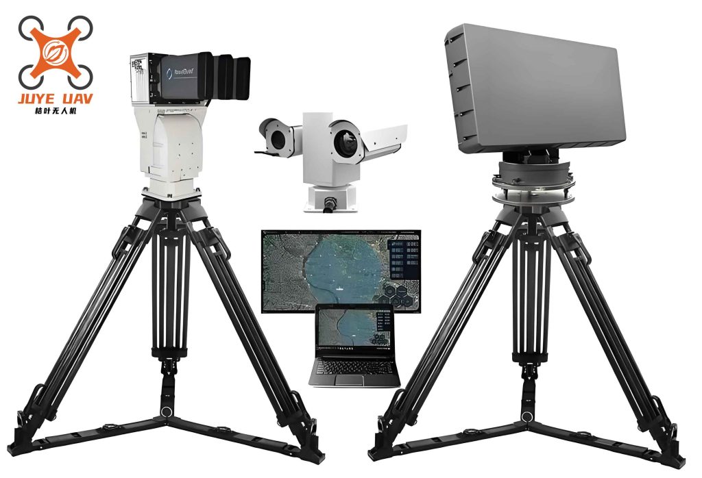
To understand the system’s operation, let’s explore its technical underpinnings. The process begins with wide-area surveillance using high-gain antennas and sensitive receivers that cover a broad frequency spectrum, typically from 400 MHz to 6 GHz, encompassing common drone communication bands like 2.4 GHz and 5.8 GHz. Upon signal interception, advanced digital signal processing (DSP) algorithms are employed to extract key parameters. These include carrier frequency, modulation type, pulse width, and signal strength. For direction finding, we utilize phase interferometry or time-difference-of-arrival (TDOA) techniques. A simplified formula for phase-based direction finding is given by:
$$ \theta = \arcsin\left(\frac{\lambda \cdot \Delta \phi}{2\pi d}\right) $$
where \(\theta\) is the angle of arrival, \(\lambda\) is the wavelength of the signal, \(\Delta \phi\) is the phase difference between two antennas, and \(d\) is the distance between the antennas. This allows us to estimate the direction of the drone or controller with high accuracy. For localization, single-station ranging is achieved by analyzing signal propagation models. In free space, the received signal power \(P_r\) can be related to distance \(r\) using the Friis transmission equation:
$$ P_r = P_t G_t G_r \left( \frac{\lambda}{4\pi r} \right)^2 $$
where \(P_t\) is the transmitted power, \(G_t\) and \(G_r\) are the antenna gains of the transmitter and receiver, respectively. By measuring \(P_r\) and knowing typical drone transmitter parameters, we can estimate \(r\) roughly. However, for precise multi-station triangulation, data from multiple nodes is fused. The table below summarizes key signal parameters measured by our anti-drone system:
| Parameter | Description | Typical Range | Importance in Anti-Drone Operations |
|---|---|---|---|
| Carrier Frequency | Center frequency of the signal | 400 MHz – 6 GHz | Identifies communication band; aids in filtering and classification. |
| Modulation Type | e.g., FSK, QPSK, OFDM | Varies by drone model | Helps in drone model identification and signal decoding. |
| Signal Strength (RSSI) | Received signal strength indicator | -120 dBm to -30 dBm | Used for distance estimation and detection thresholding. |
| Angle of Arrival (AoA) | Direction from which signal arrives | 0° to 360° | Crucial for direction finding and localization. |
| Pulse Width | Duration of signal pulses | 1 µs to 100 ms | Assists in distinguishing control signals from video streams. |
One of the standout features of our anti-drone system is its exceptional detection range. Through optimized antenna design and low-noise amplifiers, we can detect drones with transmit powers as low as 0.1 W at distances exceeding 10 km. This is particularly impressive for micro-drones with an axle base of 40 cm, which are often difficult to track. The system’s wide field of view enables continuous monitoring of large areas, automatically scanning for anomalies and triggering alerts when drone-like signals are identified. Moreover, the passive nature means it operates silently, without alerting the drone operator, giving security personnel a tactical advantage. This long-range capability is vital for perimeter defense in airports, military bases, and public venues, where early warning is key to effective anti-drone responses.
Another critical aspect is single-station localization. While multi-station networks provide high accuracy, our system can perform rough ranging from a single node by leveraging signal propagation characteristics and database of known drone signatures. For instance, by combining angle of arrival with estimated distance, we can plot a likely location on a map. The localization error \(\epsilon\) can be modeled as:
$$ \epsilon = \sqrt{(\Delta \theta \cdot r)^2 + (\Delta r)^2} $$
where \(\Delta \theta\) is the angular error in radians, \(r\) is the estimated range, and \(\Delta r\) is the range error. Typically, with our advanced algorithms, \(\epsilon\) is kept within a few hundred meters for single-station mode, which is sufficient for guiding countermeasures. For higher precision, multiple units can be deployed in a network, using triangulation. The position \((x, y)\) of a drone can be computed from \(n\) stations with known positions \((x_i, y_i)\) and measured angles \(\theta_i\) by solving:
$$ \tan(\theta_i) = \frac{y – y_i}{x – x_i} \quad \text{for } i = 1, 2, \dots, n $$
This overdetermined system is solved via least-squares estimation, enhancing accuracy. The table below compares single-station and multi-station anti-drone localization performance:
| Localization Mode | Accuracy | Range | Advantages | Limitations |
|---|---|---|---|---|
| Single-Station | 100-500 m | Up to 15 km | Low cost, easy deployment, rapid setup. | Lower precision; susceptible to multipath effects. |
| Multi-Station Triangulation | 10-50 m | Up to 20 km (networked) | High accuracy, robust to errors, 3D定位 possible. | Requires synchronization, higher infrastructure cost. |
Weather immunity is a significant advantage of our passive anti-drone system. Unlike optical or infrared sensors, which can be hampered by rain, snow, fog, or haze, radio frequency signals propagate reliably through most atmospheric conditions. This ensures uninterrupted operation 24/7, making it ideal for all-weather surveillance. The system’s hardware is designed with ruggedized enclosures, allowing deployment in harsh environments. Additionally, the lack of electromagnetic emissions means it does not contribute to spectrum pollution, aligning with green technology initiatives. This passive, weather-resistant design is a cornerstone of our anti-drone philosophy, providing reliable protection regardless of environmental challenges.
Target identification capability is where our system truly excels. Through a comprehensive database of RF fingerprints, we can identify over 95% of mainstream micro- and mini-drones on the market, including models from DJI, Parrot, and Yuneec. Each drone model has unique signal characteristics, such as specific modulation schemes, packet structures, and frequency hopping patterns. Machine learning algorithms are employed to classify these signals in real-time. For example, a support vector machine (SVM) classifier can be trained on features like spectral centroid, bandwidth, and duty cycle. The classification decision function is:
$$ f(\mathbf{x}) = \text{sign}\left( \sum_{i=1}^n \alpha_i y_i K(\mathbf{x}_i, \mathbf{x}) + b \right) $$
where \(\mathbf{x}\) is the feature vector of the intercepted signal, \(\alpha_i\) are Lagrange multipliers, \(y_i\) are class labels, \(K\) is a kernel function, and \(b\) is a bias term. This enables rapid identification, outputting the drone manufacturer and model to the operator. Moreover, the system can distinguish between drones and other RF sources, reducing false alarms. This identification prowess is crucial for tailored anti-drone responses, as different drones may require specific jamming protocols or legal considerations.
Parameter measurement extends beyond identification. Our system extracts detailed signal parameters that can guide precise electronic countermeasures. For instance, by determining the exact carrier frequency and modulation of a drone’s control link, a directed jamming gun can be calibrated to disrupt that specific link without affecting surrounding communications. This minimizes collateral interference. The system measures parameters like signal-to-noise ratio (SNR), which is vital for assessing threat level. SNR is calculated as:
$$ \text{SNR}_{\text{dB}} = 10 \log_{10}\left( \frac{P_{\text{signal}}}{P_{\text{noise}}} \right) $$
where \(P_{\text{signal}}\) and \(P_{\text{noise}}\) are the power of the signal and noise, respectively. High SNR indicates a nearby or powerful drone, triggering higher alert levels. These measurements are fed into the control center, enabling proactive anti-drone strategies.
A unique feature of our system is its ability to detect the drone operator, or “flyer.” Since the remote controller emits signals as well, by tracking the uplink commands, we can often locate the operator’s position. This is achieved through similar direction-finding techniques, and in some cases, by analyzing signal strength patterns as the operator moves. This dual detection capability—targeting both drone and flyer—enhances the effectiveness of anti-drone operations, allowing for apprehension or deterrent actions against the source of the threat. It adds a layer of deterrence, as operators know they risk being located.
The system is designed for practicality, with lightweight, low-power components that facilitate easy deployment. Each unit weighs under 10 kg and consumes less than 50 W, making it suitable for mobile setups or integration into existing infrastructure. This portability allows rapid response teams to deploy the system at temporary events, such as concerts or political gatherings. The low power consumption also supports solar-powered operation in remote areas. These attributes make our anti-drone solution versatile and accessible for various security scenarios.
In terms of applications, our anti-drone system has garnered significant recognition. It was awarded the top prize in a prestigious national competition, highlighting its innovation and effectiveness. Media outlets have extensively covered its capabilities, bringing attention to the importance of passive anti-drone technologies. Beyond accolades, the system has been deployed to secure major public events, where it successfully detected and mitigated unauthorized drone incursions, ensuring safety without disruption. These real-world validations underscore its reliability and impact in the anti-drone domain.
Looking ahead, we are continuously enhancing the system. Future developments include integrating artificial intelligence for predictive threat analysis, expanding the drone signature database, and improving network scalability for city-wide anti-drone grids. We are also exploring fusion with other sensors, such as acoustic or radar systems, to create multi-modal detection suites. However, the passive RF approach remains central, offering a balance of stealth, range, and accuracy. As drone technology evolves, so too will our anti-drone solutions, adapting to new threats like autonomous swarms or stealthier communication protocols.
In conclusion, our Passive Detection and Localization System represents a paradigm shift in anti-drone defense. By harnessing passive RF interception, it provides long-range, weather-immune, and identification-rich capabilities without emitting any radiation. Its ability to locate both drones and operators makes it a comprehensive tool for security forces. Through technical innovations and practical design, it addresses the growing drone threat effectively. As we continue to refine this technology, we remain committed to advancing anti-drone measures that protect airspace while upholding principles of sustainability and non-interference. This system is not just a product; it is a testament to the power of passive sensing in modern security landscapes.