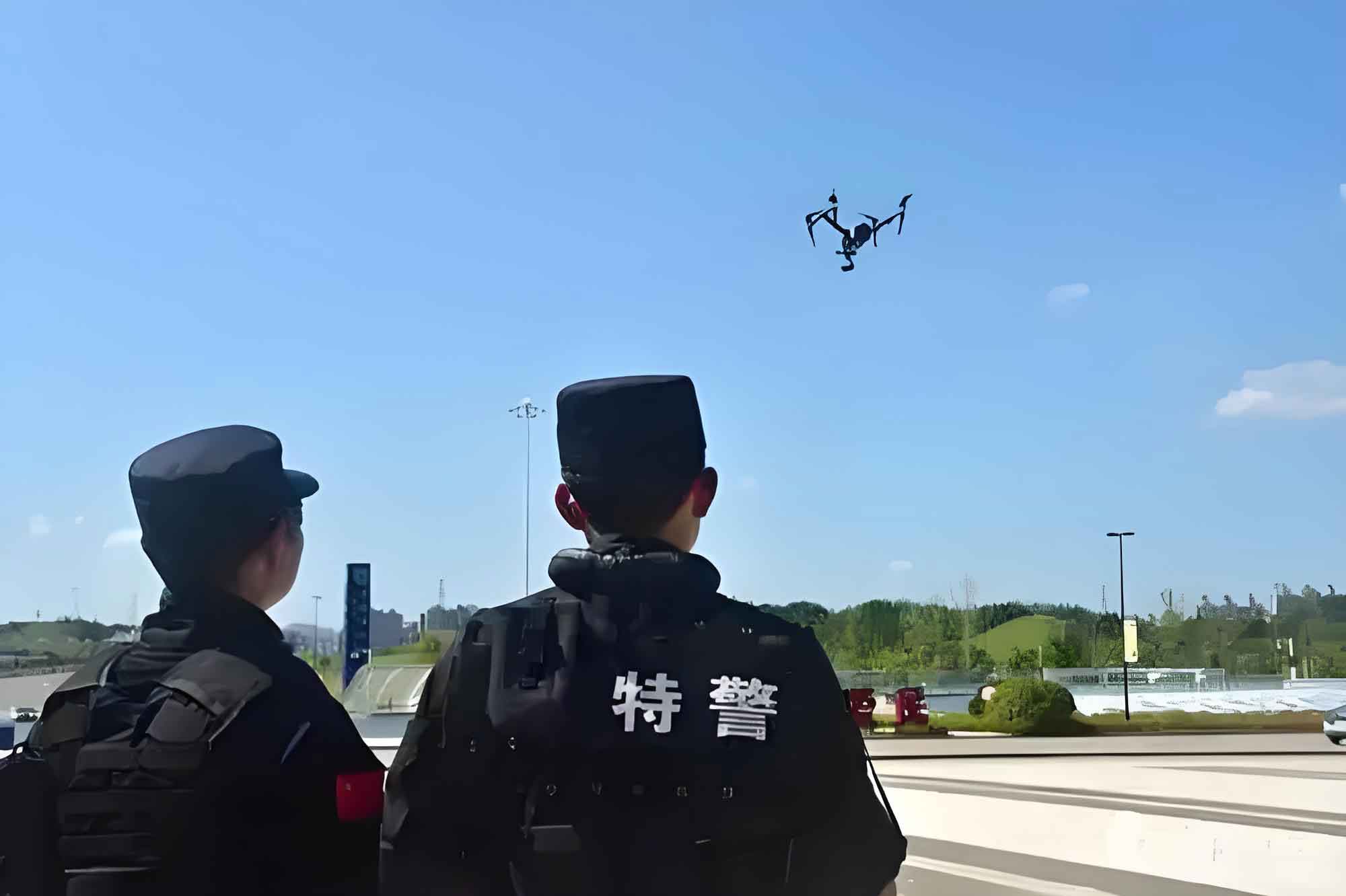
As a practitioner in the field of public security technology, I have witnessed firsthand the transformative role of police UAV (unmanned aerial vehicle) in modern law enforcement. The rapid economic development and urbanization have intensified the flow of people, vehicles, goods, and capital, leading to increasingly complex public security landscapes. Traditional methods of social governance, such as relying on two-dimensional maps or manual on-site reconnaissance, are no longer sufficient to meet the urgent demands of公安应急 scenarios. The need for real-time, visualizable command and control has become paramount. In this context, police UAV offer a versatile solution to address uncertainties in time, space, and scale during urban emergencies. Their low noise, strong隐蔽性, high reliability, and ease of use make them ideal for rapid deployment in confined urban spaces. Particularly in scenarios like crowd incidents, accident site documentation, fire scene assessment, and hazardous material detection, police UAV can “investigate accurately, monitor steadily, and transmit quickly,” providing critical decision-making support for leadership.
The局限性 of traditional measures in daily social management, such as serving the public, understanding辖区 realities, conducting security prevention, and maintaining order, have become increasingly apparent. To effectively serve communities and control治安形势, while rapidly and accurately handling突发事件, we are actively exploring and practicing the “police UAV + officer”警务巡逻新模式. This approach strengthens and innovates社会治安综合治理, maximizes the benefits of technology-aided policing, and uses智慧警务 to serve民生 and protect social development. The integration of police UAV into立体化社会治安防控体系 is not just an enhancement but a necessity for future-proofing public safety.
Before the widespread adoption of police UAV, government monitoring and management largely depended on fixed surveillance devices. However, as users delve deeper into these systems, issues like blind spots and physical damage to cameras become unavoidable. Police UAV, with their significant advantages in aerial photography, offer a promising solution to these软肋. Moreover, in remote or harsh environments, the installation, wiring, and maintenance of cameras and sensors pose major challenges. In the face of多样化 trends in visual management, fixed-point video surveillance requires supplemental technologies like police UAV航拍 to ensure coverage in特殊 situations. As a crucial component of现场可视指挥调度系统, police UAV can seamlessly transmit live video feeds into the system, enabling real-time visual应急管理. When combined with智能分析技术, this enhances on-site processing efficiency and emergency response capabilities.
By leveraging police UAV to collect various sensor data from scenes, we can迅速 transmit video, audio, alerts, and sensor information to command centers. This allows for real-time tracking of incident developments, aiding commanders in judgment and决策. The dynamic, three-dimensional, and multi-angle perspectives provided by police UAV机载摄像头 are irreplaceable, offering broad-scene observation that fixed monitoring devices cannot match. The police UAV立体防控 system employs innovative UAV application technologies and system solutions, combining police UAV platforms with video imaging, infrared sensing, intelligent mission planning,航线规划, and visual智能感知. This enables智能化监测 and科学化管控 of complex terrains, structurally intricate areas, and densely populated关键防控区域 from the air.
The police UAV立体防控 system is built on an information integration management platform, creating an intelligent,网格化, and立体化防控 network for urban areas. It comprises wireless sensors and空中 police UAV clusters forming a立体网络, integrating core functions like automatic target搜索, discovery,定位, recognition, tracking, and monitoring. It also combines信息发布, data analysis,态势研判, command调度,联动控制, and multi-system对接 into a centralized interface. This system plays a vital role in meeting social security needs, preventing and combating违法犯罪,防范恐怖暴力事件, and maintaining national security and social stability. The police UAV is central to this ecosystem, providing unparalleled aerial oversight.
Demand Analysis for Police UAV in Social治安防控 Scenarios
The需求 for police UAV stems from the increasing complexity of modern urban environments. Traditional policing methods often fall short in terms of speed, coverage, and data granularity. Police UAV address these gaps by offering rapid deployment, high-altitude视野, and multi-sensor integration. For instance, during large-scale public events, police UAV can provide real-time crowd monitoring, identifying potential disturbances before they escalate. In search and rescue operations, police UAV equipped with thermal cameras can locate missing persons in difficult terrain. The following table summarizes key demand areas and how police UAV meet them:
| Demand Area | Traditional Limitations | Police UAV Advantages | Impact on立体防控 |
|---|---|---|---|
| Real-time Surveillance | Fixed cameras with blind spots; slow manual patrols | Dynamic aerial coverage; rapid response to hotspots | Enhances situational awareness and reduces response time |
| Emergency Response | Limited access to hazardous or confined spaces | Can fly into dangerous areas (e.g., chemical spills, fires) | Improves officer safety and provides critical data |
| Traffic Management | Ground-based sensors and patrols; congestion issues | Aerial views of traffic flow; accident site documentation | Optimizes traffic control and accident investigation |
| Crowd Control | Ground officers have limited视野; risk of escalation | Overhead monitoring for crowd density and movement patterns | Enables proactive measures and de-escalation strategies |
| Environmental Monitoring | Stationary sensors with limited range | Mobile sensing for pollution, wildlife tracking, etc. | Extends monitoring capabilities to remote areas |
From a technical perspective, the effectiveness of police UAV can be quantified using metrics such as coverage area, response time, and data accuracy. For example, the coverage area \(A\) of a police UAV during a mission can be modeled as:
$$A = \pi r^2 \cdot \eta$$
where \(r\) is the effective sensing radius of the UAV’s sensors, and \(\eta\) is an efficiency factor accounting for flight patterns and environmental conditions. This formula highlights how police UAV can expand监控范围 compared to fixed installations. Moreover, the response time \(T_r\) for a police UAV to reach a target location is given by:
$$T_r = \frac{d}{v} + t_d$$
where \(d\) is the distance to the target, \(v\) is the average speed of the police UAV, and \(t_d\) is the deployment delay. In practice, police UAV often achieve \(T_r < 5\) minutes for urban areas, significantly faster than ground units. These mathematical models underscore the operational advantages of integrating police UAV into public security frameworks.
Innovative Application Scenarios of Police UAV in公安立体防控 Systems
The application of police UAV extends beyond simple surveillance to encompass a wide range of innovative scenarios that enhance立体防控. By combining police UAV with advanced technologies like AI, IoT, and big data, we can create sophisticated systems for proactive security management. One key area is in智能巡查, where police UAV are programmed to autonomously patrol designated zones, using computer vision to detect anomalies such as unauthorized gatherings, vehicle accidents, or structural damages. Another scenario is in证据收集, where police UAV capture high-resolution imagery and videos for forensic analysis, aiding in criminal investigations and legal proceedings.
In the context of反恐和维稳, police UAV play a crucial role in monitoring敏感区域, tracking suspect movements, and providing real-time intelligence to ground forces. For example, during a hostage situation, police UAV can relay live footage to command centers, enabling precise planning of rescue operations. Additionally, police UAV are increasingly used in public service applications, such as disaster assessment after natural calamities, where they can quickly survey damage and identify areas in need of urgent援助. The following table outlines some cutting-edge application scenarios:
| Scenario | Description | Key Technologies Involved | Role of Police UAV |
|---|---|---|---|
| Autonomous Patrols | Pre-programmed routes for routine surveillance of critical infrastructure (e.g., power plants, borders) | GPS, obstacle avoidance, AI-based anomaly detection | Reduces manpower needs; provides consistent monitoring |
| Incident Response Coordination | Integrating UAV feeds with ground units during emergencies (e.g., fires, explosions) | Real-time video streaming, data fusion, command software | Offers aerial视角 for指挥决策; enhances inter-agency coordination |
| Environmental Hazard Detection | Monitoring air quality, radiation levels, or chemical leaks in industrial zones | Multispectral sensors, gas detectors, data analytics | Accesses hazardous areas safely; provides early warnings |
| Traffic Flow Optimization | Managing congestion during peak hours or special events using aerial traffic data | Computer vision, traffic simulation algorithms | Collects real-time traffic patterns; suggests route adjustments |
| Search and Rescue (SAR) | Locating missing persons in wilderness or urban rubble | Thermal imaging, facial recognition, GPS tracking | Covers large areas quickly; operates in low-visibility conditions |
To quantify the benefits in these scenarios, we can use performance metrics. For instance, in SAR operations, the probability of detection \(P_d\) using police UAV can be expressed as:
$$P_d = 1 – e^{-\lambda \cdot A \cdot t}$$
where \(\lambda\) is the detection rate per unit area, \(A\) is the search area covered by the police UAV, and \(t\) is the search time. This exponential model shows that police UAV significantly increase \(P_d\) compared to ground searches, especially over large \(A\). Furthermore, the cost-effectiveness of police UAV deployments can be analyzed through ratios like \(\frac{C_{\text{benefit}}}{C_{\text{UAV}}}\), where \(C_{\text{benefit}}\) includes reduced response times, prevented incidents, and saved lives, while \(C_{\text{UAV}}\) covers acquisition, operation, and maintenance. Empirical data often shows this ratio >1, justifying investments in police UAV technology.
Intelligent Mission Planning and Route Planning for Police UAV
Currently, the operational use of police UAV is still in an exploratory phase, with issues such as lack of standardization,专业培训滞后, and insufficient飞行训练. Many departments face challenges like having police UAV equipment but no trained pilots, leading to underutilization. Moreover, without pre-planned mission and route规划行动预案, police UAV cannot be deployed promptly during emergencies, negating their advantage of rapid response. When using multiple police UAV in clusters, coordination problems often arise, hindering the full potential of大范围监控.
To address these issues, we have developed a distributed deployment and centralized control system for police UAV that incorporates intelligent mission planning and智能航线规划. This system automates the巡查 of防控区域, leveraging the强大的监控能力 of police UAV. It enables remote management and autonomous flight, eliminating the need for on-site pilots. The system also includes智能分析 capabilities for collected images and data, such as多源数据融合处理 and大数据处理, enabling real-time联合告警. The core of this system lies in algorithms that optimize police UAV operations.
Intelligent mission planning for police UAV is based on工作预案, allowing us to design missions by displaying flight routes on digital maps and simulating飞行过程. This helps规避飞行路线上的威胁 and assesses the expected effectiveness of police UAV deployments. The simulation feeds back into决策, helping formulate optimal plans. It also serves as a training tool, providing virtual environments for演习 and evaluating演练结果. Mathematically, mission planning can be formulated as an optimization problem. Let \(M\) represent a mission for a police UAV, defined by objectives like area coverage or target tracking. We aim to minimize a cost function \(C(M)\), which might include factors like energy consumption, time, and risk. For a police UAV, this can be expressed as:
$$C(M) = \alpha \cdot E(M) + \beta \cdot T(M) + \gamma \cdot R(M)$$
where \(E(M)\) is the energy used, \(T(M)\) is the mission duration, \(R(M)\) is the risk level (e.g., from obstacles or threats), and \(\alpha, \beta, \gamma\) are weighting coefficients. By solving this optimization, we generate efficient mission plans for police UAV.
The智能航线规划 subsystem integrates with 3D maps to control police UAV for automatic布控 of target points, with real-time video transmission. It automatically computes routes from the police UAV’s current position to task points, avoiding obstacles en route. The subsystem pre-plans routes, enabling fully autonomous flight, including details like latitude, longitude, altitude at waypoints, and operations of mission equipment. Route planning for police UAV often uses algorithms such as A* or Dijkstra’s for pathfinding in complex environments. For instance, the shortest path for a police UAV to navigate from point \(A\) to \(B\) while avoiding no-fly zones can be computed using graph theory, where nodes represent possible positions and edges represent feasible movements. The cost of each edge might incorporate factors like distance \(d_{ij}\) and threat level \(t_{ij}\):
$$c_{ij} = w_d \cdot d_{ij} + w_t \cdot t_{ij}$$
where \(w_d\) and \(w_t\) are weights. The system then finds the path that minimizes total cost, ensuring safe and efficient routes for police UAV. Below is a table summarizing key components of intelligent planning for police UAV:
| Component | Function | Algorithm/Technique | Benefit for Police UAV |
|---|---|---|---|
| Mission Planning | Defines objectives, constraints, and resources for police UAV tasks | Optimization models (e.g., linear programming, genetic algorithms) | Enhances mission success rates and resource allocation |
| Route Planning | Generates safe and efficient flight paths for police UAV | Graph-based搜索 (e.g., A*, RRT), 3D mapping | Reduces collision risks and improves navigation accuracy |
| Simulation | Tests police UAV missions in virtual environments before execution | Digital twins, physics-based modeling | Lowers operational costs and allows for scenario training |
| Real-time Adaptation | Adjusts police UAV routes dynamically based on live data (e.g., weather, new threats) | Machine learning, sensor fusion | Increases resilience and responsiveness in changing conditions |
In practice, these planning systems for police UAV can reduce mission preparation time by up to 70%, according to pilot studies. The integration of AI further allows police UAV to learn from past missions, continuously improving planning accuracy. For example, reinforcement learning can be used to optimize police UAV routes over time, with rewards based on mission outcomes. The Q-learning update rule for a police UAV navigating a grid might be:
$$Q(s,a) \leftarrow Q(s,a) + \alpha [r + \gamma \max_{a’} Q(s’,a’) – Q(s,a)]$$
where \(s\) is the state (e.g., position), \(a\) is the action (e.g., move direction), \(r\) is the reward (e.g., reaching a waypoint), and \(\alpha, \gamma\) are learning parameters. This enables police UAV to autonomously refine their strategies, making them more effective in立体防控 operations.
Integration of Police UAV with公安防控应用系统 for Air-Ground一体化智能防控
A current challenge is the disconnection between police UAV and公安信息化系统. Most police UAV are used merely as tools, not integrated into the broader公安业务信息系统. While police UAV excel as mobile aerial sensors for信息搜集, they often remain isolated from backend command centers, impacting指挥决策效率 during emergencies. This disconnect prevents the空中巡查 and information-gathering advantages of police UAV from translating into rapid处置 and打击优势.
To overcome this, we have developed solutions that align with公安 users’ needs in应急,处突,维稳, and反恐. These involve centralized management of police UAV for空中视频巡查, automatic target发现,识别,定位, tracking, and analysis. By integrating police UAV with ground monitoring devices, we can fuse collected images, audio, data, and地理信息 in real time, displaying them on a unified platform. The一体化指挥调度中心 then uses this fused information to command and control all终端设备 and government resources, enabling coordinated air-ground联合行动.
The police UAV立体防控 system triggers相应的应急预案 based on different危情告警. It uses police UAV to automatically guide ground personnel to incident sites via synchronized mobile clients. Simultaneously, the system dispatches待命的 police UAV to the现场位置 for video monitoring,空中取证,智能分析, and预案处理. This seamless integration ensures that police UAV become an integral part of the decision-making loop. For instance, during a protest, police UAV can stream live footage to commanders, who then direct ground units to specific hotspots, all within minutes.
Mathematically, the effectiveness of such integrated systems can be measured by metrics like system responsiveness \(S_r\) and coordination efficiency \(C_e\). Let \(N_{\text{UAV}}\) be the number of police UAV deployed, and \(N_{\text{ground}}\) be the number of ground units. The overall system performance \(P\) might be modeled as:
$$P = f(N_{\text{UAV}}, N_{\text{ground}}, I_{\text{fusion}}, T_{\text{delay}})$$
where \(I_{\text{fusion}}\) is the quality of data fusion (e.g., from 0 to 1), and \(T_{\text{delay}}\) is the communication delay between police UAV and command. By minimizing \(T_{\text{delay}}\) and maximizing \(I_{\text{fusion}}\), we enhance \(P\). In practice, using 5G networks can reduce \(T_{\text{delay}}\) to under 10 ms for police UAV, enabling near-instantaneous data sharing.
The integration also involves智能识别和分析 of video feeds from police UAV. For example, AI algorithms can detect suspicious behaviors or recognize license plates, with accuracy rates often exceeding 90%. The recognition process for a police UAV can be described as a function \(F(I)\), where \(I\) is the input image from the police UAV’s camera, and the output is a set of detected objects or events. Using convolutional neural networks (CNNs), this can be expressed as:
$$F(I) = \text{CNN}(I; \theta)$$
where \(\theta\) are learned parameters from training data involving police UAV footage. This enables automatic alerting when anomalies are detected by police UAV, reducing the workload on human operators.
The following table illustrates the components of an air-ground一体化智能防控 system centered on police UAV:
| System Layer | Components | Function in Relation to Police UAV | Outcome |
|---|---|---|---|
| Sensing Layer | Police UAV, ground cameras, IoT sensors | Police UAV provide aerial data; ground devices offer complementary views | Comprehensive situational awareness |
| Communication Layer | 5G networks, satellite links, mesh networks | Ensures real-time transmission of police UAV data to command centers | Low-latency, reliable connectivity for police UAV operations |
| Data Fusion Layer | AI algorithms, big data platforms | Integrates police UAV feeds with other sources for holistic analysis | Enhanced decision-making through multi-source intelligence |
| Command and Control Layer | Unified software dashboards, mobile apps | Allows commanders to direct police UAV and ground units simultaneously | Coordinated responses and efficient resource deployment |
| Application Layer | Emergency response modules, traffic management, etc. | Utilizes police UAV data for specific公安业务 (e.g., crowd control, SAR) | Tailored solutions for diverse public security challenges |
By implementing such systems, we have observed reductions in incident resolution times by up to 50% in pilot cities. The police UAV not only augment ground efforts but also enable new capabilities like predictive policing, where data from police UAV are analyzed to forecast crime hotspots. This predictive model might use historical police UAV data along with其他变量 like weather and social media trends, formulated as:
$$P(\text{crime at } x,t) = g(\text{UAV data}(x,t-1), \text{weather}, \text{sentiment score})$$
where \(g\) is a machine learning model. Thus, police UAV become proactive tools in立体防控, shifting from reactive to preventive strategies.
Conclusion
In summary, police UAV offer exceptional mobility and, when paired with intelligent management and command software, enable全方位,立体化, and实时化监控. They significantly expand监控范围 and satisfy the立体化社会治安防控需求 of公安民警 through an air-ground一体监控体系. Police UAV are capable of空中监控, daily巡逻,搜索跟踪, and more, earning growing favor among警务部门. From公安干警 using police UAV for突发事件 to交警 managing traffic and特警 conducting空中侦察, the applications are vast. In the future, police UAV will assist various government agencies in public security, extending to应急,消防,交通, and other执法 fields. They will efficiently handle急难险重任务 like应急救援,陆地搜救,应急追踪, and现场取证. As a杀手锏 in信息化条件下的警务工作, police UAV are indispensable for打击罪犯,维护稳定, and服务人民. Their ongoing evolution promises even greater advancements, solidifying their role as a cornerstone of modern public safety systems. The continuous innovation in police UAV technology, coupled with deeper integration into立体防控 frameworks, heralds a new era of智能 and responsive law enforcement.
To further illustrate the technical aspects, consider the energy management of police UAV during long missions. The flight time \(T_f\) of a police UAV can be estimated using the battery capacity \(B\) (in Wh) and power consumption \(P_c\) (in W):
$$T_f = \frac{B}{P_c} \cdot \epsilon$$
where \(\epsilon\) is an efficiency factor (typically 0.7-0.9). Optimizing \(T_f\) is crucial for extending police UAV operations, often through improvements in battery technology or aerodynamic design. Additionally, the scalability of police UAV networks can be analyzed using graph models, where each police UAV is a node in a communication network. The connectivity \(C_n\) of such a network, important for协同工作, might be defined as:
$$C_n = \frac{2 \cdot L}{N \cdot (N-1)}$$
where \(L\) is the number of active links between police UAV, and \(N\) is the total number of police UAV. Maximizing \(C_n\) ensures robust data sharing among police UAV clusters. These formulas underscore the multifaceted nature of police UAV systems, blending engineering, computer science, and security studies to achieve effective立体防控.