
From my perspective, the integration of unmanned aerial vehicle (UAV) technology into the law enforcement domain represents a pivotal evolution in investigative methodology. As a tool, the police drone is fundamentally a remotely piloted or autonomously operated aircraft, equipped with embedded systems and modular payloads that facilitate real-time data transmission to command platforms. This capability has initiated a significant shift from traditional, ground-bound investigative procedures towards more dynamic, intelligence-led, and spatially comprehensive operations. The primary categories of police drones—fixed-wing, multi-rotor, and vertical take-off and landing (VTOL) models—each offer distinct advantages and limitations for investigative tasks.
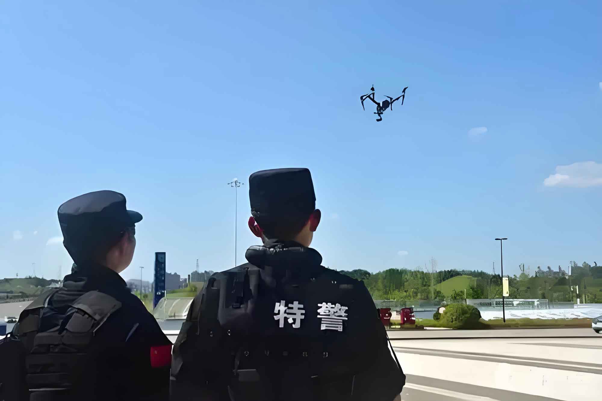
The operational efficacy of a police drone in investigations can be modeled as a function of its core attributes: endurance, payload capacity, stability, and data link integrity. We can express the theoretical operational window for a surveillance or evidence-gathering mission as:
$$
T_{effective} = \min(E_{battery} – P_{payload} \cdot C_{power}, T_{weather}, T_{regulatory})
$$
Where $T_{effective}$ is the usable mission time, $E_{battery}$ is the total battery energy, $P_{payload}$ is the power draw coefficient of the sensor payload, $C_{power}$ is a constant, $T_{weather}$ is the operational limit imposed by environmental conditions, and $T_{regulatory}$ is the permissible flight duration under aviation rules. This equation highlights the multifaceted constraints under which a police drone operates.
| Drone Type | Strengths for Investigation | Weaknesses for Investigation | Typical Investigative Use Case |
|---|---|---|---|
| Fixed-Wing Police Drone | Long endurance, large coverage area, high speed. | Requires runway or launcher; poor hover capability. | Large-area searches (e.g., missing persons in rural zones). |
| Multi-Rotor Police Drone | Vertical take-off/landing, excellent hover stability, low cost. | Short flight time, limited payload, vulnerable to wind. | Close-quarters scene documentation, crowd monitoring. |
| VTOL Police Drone | Combines endurance of fixed-wing with hover ability of multi-rotor. | Higher cost, complex maintenance, nascent regulatory standards. | Prolonged tactical surveillance over a specific location. |
I. Multifaceted Applications in the Investigative Process
In my analysis, the police drone has transitioned from a novel gadget to a core platform enhancing multiple, distinct phases of the investigative workflow.
A. Scene Assessment and Three-Dimensional Forensic Mapping
The primary advantage of the police drone is its ability to transcend physical and hazardous barriers. In major incident scenes—such as industrial accidents, train derailments, or expansive outdoor crime scenes—deploying a police drone provides an immediate aerial overview that is unattainable from the ground. This is not merely about taking photographs; it is about constructing accurate, measurable spatial models. Using photogrammetry software, hundreds of overlapping images captured by a police drone are processed to generate high-fidelity 3D models, orthomosaics, and digital elevation models.
The metric for reconstruction accuracy is crucial. The ground sample distance (GSD), which determines the resolution of the final model, is given by:
$$
GSD = \frac{H \cdot s}{f}
$$
where $H$ is the flight altitude, $s$ is the sensor pixel size, and $f$ is the lens focal length. A police drone operator must balance a low GSD (requiring low altitude) for detail with sufficient coverage area (requiring higher altitude), optimizing this equation for the scene’s needs. These 3D models allow investigators to take virtual walkthroughs long after the scene is released, measure distances between evidence points precisely, and visualize sightlines or trajectories, thereby offering an objective spatial record that supports hypothesis testing and courtroom presentation.
B. Evidence Discovery and Covert Intelligence Gathering
The modularity of the police drone is its greatest asset for evidence collection. By swapping payloads, the same platform can be reconfigured for diverse detection missions. For environmental crimes like illegal dumping or deforestation, multispectral sensors on a police drone can detect changes in vegetation health not visible to the naked eye, quantifying the extent of damage. In narcotics operations, a police drone equipped with a LiDAR scanner can penetrate forest canopies to identify hidden structures or paths.
For nighttime surveillance or search-and-rescue, thermal imaging payloads detect heat signatures. The ability to distinguish a human form from ambient background relies on the differential emissivity and temperature. A police drone with a high-resolution thermal camera can effectively perform wide-area searches in challenging terrain, turning a needle-in-a-haystack problem into a manageable sensor data filtration task. This capability transforms the police drone into a persistent, unblinking eye, gathering intelligence over prolonged periods without alerting subjects, a tactic invaluable in cases involving organized crime or surveillance of sensitive locations.
C. Tactical Support and Apprehension Operations
During dynamic incidents such as the pursuit of an armed suspect or the containment of a barricaded subject, the police drone serves as a critical force multiplier and risk mitigator. It provides real-time, overhead video feeds to command posts and tactical units, offering a perspective that ground officers cannot achieve. This “overwatch” function enhances situational awareness, tracks suspect movement, and can identify potential ambush points or hidden accomplices.
The tactical advantage can be modeled as an increase in operational safety ($S_{op}$) and a decrease in perpetrator elusion probability ($P_e$):
$$
S_{op} \propto \frac{1}{R_{direct}}, \quad \text{where } R_{direct} \text{ is risk of direct officer engagement}
$$
$$
P_e \propto \frac{1}{C_{awareness}}, \quad \text{where } C_{awareness} \text{ is commander’s situational awareness}
$$
The police drone directly reduces $R_{direct}$ by allowing remote reconnaissance and increases $C_{awareness}$, thereby lowering $P_e$. Furthermore, specialized police drone models can be equipped with loudspeakers for negotiation, bright lights for illumination, or even non-lethal payloads. In one documented case, a police drone was used to deliver a mobile phone to a barricaded individual to initiate communication, resolving a standoff without physical confrontation.
| Investigative Phase | Police Drone Application | Key Technology/Module | Outcome/Value |
|---|---|---|---|
| Initial Response & Scene Preservation | Aerial overview, rapid scene documentation. | High-resolution RGB camera, live video downlink. | Establishes perimeter, guides resource deployment, creates initial record. |
| Detailed Forensic Investigation | 3D mapping, evidence location marking, trajectory analysis. | Photogrammetry software, RTK-GPS for precision. | Creates immutable, measurable spatial model for analysis and court. |
| Covert Investigation | Surveillance, suspect tracking, evidence pre-raid verification. | Thermal camera, zoom camera, silent rotors. | Gathers intelligence with minimal risk of detection or officer exposure. |
| Tactical Resolution | Overwatch, communication delivery, less-lethal option deployment. | Loudspeaker, drop mechanism, high-lumen light. | Enhances officer safety, de-escalates situations, enables precise action. |
II. Systemic Challenges and Operational Dilemmas
Despite its transformative potential, the integration of the police drone into mainstream investigative practice is hampered by a confluence of technological, organizational, and legal-regulatory constraints.
A. Technological Stagnation and Inherent Limitations
The core physics of current police drone technology presents a ceiling for performance. The energy density of lithium-polymer batteries has seen only incremental improvements. This directly limits endurance, which is the single greatest complaint from operators. For a multi-rotor police drone, the flight time $T$ is largely a function of battery capacity $C$ (in mAh), voltage $V$, and the total power draw of the system $P_{total}$ (motors, avionics, payload):
$$
T \approx \frac{C \cdot V \cdot \eta}{P_{total}}
$$
where $\eta$ is an efficiency factor. To increase $T$, one must increase $C$ or $V$, which adds weight, or decrease $P_{total}$, which often conflicts with the need for more powerful sensors or motors for stability. This creates a vicious cycle. Furthermore, secure and robust data links for encrypted video transmission over long ranges remain vulnerable to interference, intentional jamming, or spoofing, which could compromise an entire police drone operation.
| Technical Bottleneck | Impact on Investigation | Current Mitigation | Future Need |
|---|---|---|---|
| Limited Battery Endurance | Disrupts prolonged surveillance; requires multiple drones/operators for long tasks. | Swapping batteries, using multiple drones in relay. | Higher energy-density batteries (solid-state), hybrid propulsion. |
| Payload vs. Performance Trade-off | High-res sensors reduce flight time and agility; light payloads lack capability. | Mission-specific drone fleets. | Advanced composite materials, more efficient sensor miniaturization. |
| Vulnerable Data Link | Risk of lost control, intercepted footage, or spoofing leading to crash. | Frequency hopping, basic encryption. | Military-grade encrypted links, AI-based anti-spoofing. |
| Adverse Weather Operation | Grounds drones in rain, snow, or high winds, creating operational gaps. | Weather monitoring, flight cancellations. | All-weather drone designs, advanced flight control systems. |
B. Organizational Asymmetry and Skill Gaps
There is a profound disparity in police drone adoption and proficiency across different jurisdictions. Well-funded metropolitan agencies may have dedicated UAV units with standardized training, advanced platforms, and integrated command-and-control systems. In contrast, rural or underfunded departments may rely on a single enthusiast-officer using a commercial-grade drone with minimal formal training. This “patchwork” development hinders regional interoperability during major investigations requiring cross-jurisdictional support.
The lack of standardized, advanced training is a critical vulnerability. Operating a police drone for evidence collection is not the same as flying a recreational drone. It requires knowledge of aviation regulations, photography principles for forensics, data management protocols, and tactical deployment strategies. Without this, the evidentiary value of drone-captured data can be challenged in court, and operational safety is jeopardized.
C. Immature Regulatory and Legal Frameworks
The airspace is a shared, regulated domain. While regulations for commercial drones exist, operations by a police drone unit often fall into a gray area, especially during exigent circumstances. The process for obtaining rapid airspace authorization for a time-sensitive investigation can be cumbersome. More critically, the legal doctrines surrounding evidence obtained by police drone are still evolving. Key questions persist:
- Privacy vs. Surveillance: At what altitude and for what duration does a police drone‘s observation constitute a “search” under the Fourth Amendment? Does filming a backyard from 400 feet require a warrant?
- Data Management and Retention: What are the protocols for storing, analyzing, and ultimately disposing of the massive amounts of video and image data collected by a police drone, especially data capturing non-suspects?
- Liability and Accident Response: Who is liable—the pilot, the agency, or the manufacturer—if a police drone malfunctions and causes property damage or personal injury during a pursuit?
These are not merely technical issues; they are fundamental legal and ethical dilemmas that lack clear, nationally consistent answers, creating a chilling effect on the proactive use of police drone technology.
III. Pathways to Optimization and Sustainable Integration
Overcoming these challenges requires a multi-pronged strategy that addresses technology, human capital, and the legal ecosystem simultaneously.
A. Fostering Technological Innovation Through Directed Partnerships
Law enforcement agencies cannot be mere consumers of technology. They must actively shape its development. This requires formalized partnerships between police departments, forensic institutes, and aerospace/technology companies. Agencies should publish detailed “Operational Requirements Documents” outlining their needs: e.g., “a police drone capable of 120-minute flight time with a 2kg payload of a hyperspectral imager, operable in 25-knot winds.”
Investment should be channeled towards breakthrough areas. The return on investment (ROI) for a next-generation police drone system should be evaluated not just on unit cost but on total investigative efficacy:
$$
ROI_{Drone} = \frac{\sum (C_{saved} + V_{added})}{C_{acquisition} + C_{training} + C_{maintenance}}
$$
where $C_{saved}$ includes reduced man-hours for searches, lower overtime, and avoided physical risks, while $V_{added}$ includes the value of stronger evidence, higher closure rates, and enhanced public trust. Governments can incentivize innovation through grants, tax breaks, and “test-bed” programs where manufacturers collaborate directly with elite police drone units in real-world scenarios.
B. Standardizing Training and Building Professional Capacity
The role of the police drone pilot must be professionalized. I advocate for a tiered certification system, analogous to pilot licenses:
- Basic Operator: For routine scene documentation and basic photography.
- Advanced Forensic Technician: Certified in 3D mapping, photogrammetry, and evidence collection protocols for court.
- Tical Flight Officer: Trained in covert surveillance, tactical deployment in high-risk scenarios, and counter-drone measures.
This training should be centralized at national or regional public safety aviation centers, ensuring uniformity and high standards. Furthermore, police drone units should be staffed as dedicated, full-time positions, not collateral duties, to allow for continuous skill development and procedural refinement.
C. Enacting Clear, Privacy-Centric Legal Frameworks
Legislation must provide clear guidelines that balance investigative power with civil liberties. A proposed legislative model could be based on a risk-tiered approach:
| Police Drone Mission Tier | Privacy Intrusiveness | Required Authorization | Data Handling Mandate |
|---|---|---|---|
| Tier 1: Public Event Monitoring, Disaster Response | Low (broad, public area) | Internal operational plan. | Data deleted after 30 days unless part of an incident. |
| Tier 2: Crime Scene Documentation, Search & Rescue | Medium (focused on a scene) | Supervisory approval, incident-based. | Retained as evidence; non-relevant data (e.g., bystanders) redacted/anonymized. |
| Tier 3: Targeted Surveillance, Suspect Tracking | High (focus on individual/location) | Judicial warrant based on probable cause, specifying duration/scope. | Highly restricted access, stringent chain-of-custody, mandatory audit logs. |
This framework provides predictable rules for officers and clear privacy safeguards for the public. Additionally, laws must explicitly define liability, likely following a principle of agency responsibility: the law enforcement department is ultimately liable for the actions of its police drone systems, creating a strong incentive for rigorous training and maintenance protocols.
In my concluding assessment, the police drone is an indispensable but still-maturing component of the modern investigative toolkit. Its value in enhancing officer safety, improving evidentiary quality, and increasing operational efficiency is unequivocal. However, reaping its full potential requires moving beyond ad-hoc adoption. It demands a concerted, systemic effort to overcome technological inertia through innovation, to professionalize its human operators through standardized training, and to anchor its use in a robust legal framework that commands public trust. The future of investigation is not merely automated; it is aerially augmented, intelligently networked, and ethically grounded. The trajectory of the police drone will be a definitive indicator of how successfully law enforcement navigates this complex transition.