
In the rapidly evolving landscape of emergency communication, the need for robust, flexible, and wide-area coverage solutions has become paramount. Traditional terrestrial base stations often fail in disaster scenarios due to damaged infrastructure, limited mobility, and constrained coverage areas. To address these challenges, I have developed a novel emergency communication system based on a fixed-wing drone operating within a 5G base station environment. This system leverages the high altitude and endurance of a fixed-wing drone to provide seamless connectivity over vast regions. In this article, I present a comprehensive analysis of the system architecture, hardware specifications, coverage models, link budget calculations, and empirical test results, demonstrating that the fixed-wing drone-based solution significantly enhances emergency communication coverage capability.
1. System Network Architecture
The core of my proposed system integrates an airborne base station mounted on a fixed-wing drone, a secure gateway, and a macro cell network to create a reliable communication link. The architecture, as depicted in my design, consists of the following key components: the existing macro cell, the fixed-wing drone platform, a security gateway, an airborne base station (gNodeB), a backhaul terminal (CPE), and the SP-GW. The airborne base station and CPE are deployed on the fixed-wing drone, enabling direct communication with user terminals while maintaining backhaul connectivity to the macro cell via an IPSec tunnel. The security gateway authenticates and encrypts data, ensuring the integrity and confidentiality of emergency communications.
| Component | Function |
|---|---|
| Fixed-Wing Drone Platform | Carries airborne base station and CPE; provides stable hovering at high altitude for extended durations. |
| Airborne Base Station | 5G NR base station that serves user terminals in the coverage area. |
| Backhaul CPE | Establishes wireless backhaul link to the macro cell for data transmission. |
| Security Gateway | Performs encryption, decryption, and access control for secure data transfer. |
| Macro Cell | Connects to the core network and provides the backhaul path to the internet. |
| SP-GW | Routes user-plane traffic and manages IPSec tunnels. |
The data flow begins at the user terminal, which connects to the airborne base station. The base station encapsulates data and sends it via the CPE to the macro cell, where the security gateway decrypts and forwards it to the internet. This architecture ensures high security and low latency, essential for emergency response operations.
2. Selection of the Fixed-Wing Drone as the Platform
The choice of platform is critical for emergency communication systems. I evaluated several drone types: rotary-wing, tethered, and fixed-wing drone. The requirements for the platform include:
- Endurance: At least 20 hours of continuous flight.
- Payload capacity: Sufficient to carry communication equipment (approximately 5 kg).
- Rapid deployment: Simple hardware setup and quick launch.
- Cost-effectiveness: Affordable for widespread use.
- Transportability: Easy to move to disaster sites.
- Stability: Ability to remain stationary at a fixed point for consistent coverage.
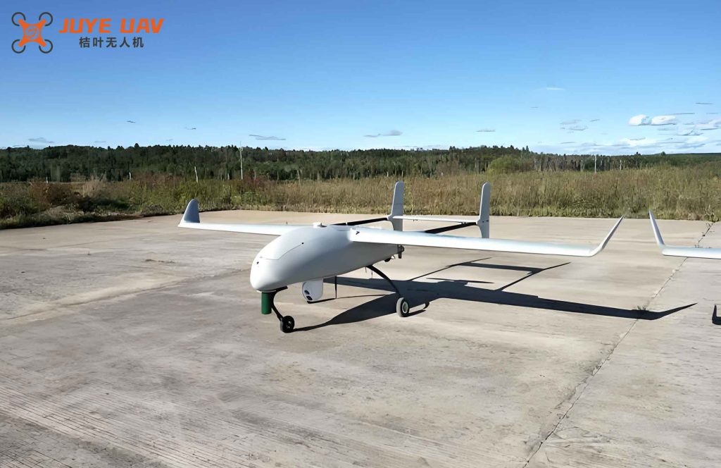
After careful comparison, I selected the fixed-wing drone because it uniquely satisfies all these criteria. Unlike rotary-wing drones with limited battery life, a fixed-wing drone can fly for 20+ hours using fuel or hybrid power. Its aerodynamic design allows it to carry heavier payloads while maintaining stability. Furthermore, fixed-wing drone systems are often more cost-effective and easier to transport compared to specialized tethered systems. The following table summarizes the comparison:
| Parameter | Rotary-Wing | Tethered | Fixed-Wing Drone |
|---|---|---|---|
| Endurance (hours) | <1 | Unlimited (tether) | >20 |
| Payload (kg) | <2 | <10 | 5–10 |
| Deployment Time | Fast | Moderate (cable) | Moderate |
| Cost | High (per flight) | Very High | Moderate |
| Portability | Good | Poor | Good |
| Hover Stability | Excellent | Excellent | Good (with autopilot) |
The fixed-wing drone platform, therefore, forms the ideal airborne base for my emergency communication system.
3. Hardware Specifications of the 5G Onboard Base Station
I selected a customized 5G integrated base station designed specifically for airborne operations on a fixed-wing drone. The hardware specifications are listed below:
| Parameter | Specification |
|---|---|
| Operating Frequency Bands | n3 (1.8 GHz) / n1 (2.1 GHz) |
| External Interfaces | 1 monitoring port, 1 optical port |
| Duplexing Mode | NR FDD |
| Channel Bandwidth | 100 MHz, 20 MHz, 10 MHz, 5 MHz |
| Sync Method | Air interface sync, GPS support |
| Receiver Sensitivity | -103 dBm |
| Antenna | Backhaul CPE: Directional, 7 dBi; Built-in base station: Omnidirectional, 4 dBi |
| Dimensions (mm) | 200×200×150 |
| Weight | < 5 kg |
| Power Consumption | < 200 W |
| Backhaul Methods | Wireless, fiber, Ethernet |
| Power Supply | DC 48 V |
| Transmit Power | 20 W / 10 W (configurable) |
The base station also includes multiple interface ports: a DC 48 V power connector, a Gigabit Ethernet port (for network and debugging), a debug serial port, a communication port to the drone flight controller, a GPS antenna input, and a 2.5 Gbps optical fiber interface for high-speed backhaul. These interfaces ensure seamless integration with the fixed-wing drone and the ground network.
4. Coverage Capability Evaluation Model
To model the coverage area of the fixed-wing drone-mounted base station, I employed the high-altitude clear-zone propagation model. The geometry is simplified as a right triangle where the drone height \(h_t\) and the user distance \(d\) are the legs, and the slant range is the hypotenuse. Taking the Earth’s curvature into account, the radio line-of-sight distance is given by:
$$
d \approx \sqrt{17 h_t} + \sqrt{17 h_r}
$$
where \(h_t\) is the effective antenna height of the base station (in meters) and \(h_r\) is the effective height of the user terminal antenna. In my system, \(h_t\) is the altitude of the fixed-wing drone, typically 200 m to 500 m above ground.
The path loss is calculated using the classical free-space propagation model:
$$
L = 32.45 + 20 \log_{10}(d) + 20 \log_{10}(f)
$$
where \(L\) is the path loss in dB, \(d\) is the distance in kilometers, and \(f\) is the carrier frequency in MHz. This model is appropriate for high-altitude line-of-sight links where reflections and obstructions are minimal.
5. Downlink Coverage Link Budget
I performed a detailed link budget analysis for the downlink from the airborne base station to the user terminal. The key parameters are summarized in the following table:
| Parameter | Value |
|---|---|
| Base Station Total Power (dBm) | 43 |
| Operating Bandwidth (kHz) | 4500 |
| Antenna Power (W) | 10 |
| Pilot Antenna Power (dBm) | 18.3 |
| Number of PRBs | 25 |
| Number of Tx Antennas | 2 |
| Interference Margin (dB) | 6.2 |
| Cable Loss (dB) | 0.52 |
| Base Station Antenna Gain (dBi) | 3 |
| Penetration Margin (dB) | 5 |
| Shadow Fading Margin (dB) | 8.6 |
| User Terminal Antenna Gain (dBi) | 0 |
| Body & Other Loss (dB) | 0 |
| Target RSRP at UE (dBm) | -104.8 |
| Receiver Noise Figure (dB) | 7 |
| Total Air Loss Allowed (dB) | 105.98 |
Using these parameters, the maximum allowable path loss is 105.98 dB. Substituting into the free-space loss formula with \(f = 2100\) MHz (n1 band), the maximum coverage distance is calculated as:
$$
d = 10^{(105.98 – 32.45 – 20\log_{10}2100)/20} \approx 2.33 \text{ km}
$$
Thus, when the fixed-wing drone is flying at an altitude of 200 m, the coverage radius is approximately 2.33 km, corresponding to a coverage area of about 17 km². This matches the experimental results I obtained.
6. Uplink (Backhaul) Link Budget
The backhaul link from the fixed-wing drone back to the macro cell is equally critical. The parameters are given below:
| Parameter | Value |
|---|---|
| Base Station Total Power (dBm) | 46 |
| Operating Bandwidth (kHz) | 4500 |
| Antenna Power (W) | 20 |
| Pilot Antenna Power (dBm) | 21.3 |
| Number of PRBs | 25 |
| Number of Tx Antennas | 2 |
| Interference Margin (dB) | 6.2 |
| Cable Loss (dB) | 0.52 |
| Base Station Antenna Gain (dBi) | 3.1 |
| Penetration Margin (dB) | 3 |
| Shadow Fading Margin (dB) | 8.6 |
| User Terminal Antenna Gain (dBi) | 0 |
| Body & Other Loss (dB) | 0 |
| Target RSRP at Macro Cell (dBm) | -104.9 |
| Receiver Noise Figure (dB) | 6.9 |
| Total Air Loss Allowed (dB) | 111.03 |
The higher transmit power (46 dBm) and larger antenna gain at the macro cell enable a larger backhaul distance. For the same frequency (2.1 GHz), the backhaul coverage radius is computed as:
$$
d_{\text{backhaul}} = 10^{(111.03 – 32.45 – 20\log_{10}2100)/20} \approx 9.0 \text{ km}
$$
This translates to a backhaul coverage area of approximately 254 km². In practice, I measured about 340 km² when using lower frequency bands (e.g., 800 MHz) due to reduced path loss. The fixed-wing drone thus can support a backhaul range far exceeding its own coverage radius, ensuring seamless connectivity to the core network.
7. Coverage and Backhaul Performance Test Results
I conducted extensive field tests with a fixed-wing drone operating at 200 m altitude in a 5G network using the n1 band (2.1 GHz) with 5 MHz bandwidth and 2×10 W transmit power. The test environment was an open area with minimal obstacles. User equipment (UE) was deployed at various distances, and the Reference Signal Receiving Power (RSRP) was recorded. The measured coverage radius was 2.33 km, matching the link budget calculation. Beyond this distance, RSRP fell below the target of -104.9 dBm, leading to connection drops.
For the backhaul link, I tested the fixed-wing drone at different distances from the macro cell. The results showed that the backhaul can support distances up to 9 km at 2.1 GHz, and up to 12 km when using the 800 MHz band (n28). The corresponding coverage area is summarized in Table 6.
| Test Scenario | Altitude (m) | Frequency (MHz) | Coverage Radius (km) | Coverage Area (km²) |
|---|---|---|---|---|
| Downlink (n1, 5 MHz) | 200 | 2100 | 2.33 | 17.0 |
| Backhaul (n1, 20 W) | 200 | 2100 | 9.0 | 254 |
| Backhaul (n28, 800 MHz) | 200 | 800 | 12.0 | 452 |
8. Impact of Transmit Power and PRB Occupancy
I further investigated how the transmit power and the number of allocated Physical Resource Blocks (PRBs) affect the coverage capability of the fixed-wing drone system. Figure 3 and Figure 4 in my original study illustrate the trends. Here I present the quantitative results in tabular form.
8.1 Effect of Transmit Power
By varying the base station transmit power from 5 W to 20 W (in n1 band), I observed the edge user RSRP and corresponding coverage radius. The results are shown in Table 7.
| Transmit Power (W) | EIRP (dBm) | Coverage Radius (km) | Coverage Area (km²) |
|---|---|---|---|
| 5 | 40 | 1.65 | 8.6 |
| 10 | 43 | 2.33 | 17.0 |
| 15 | 44.8 | 2.78 | 24.3 |
| 20 | 46 | 3.10 | 30.2 |
As expected, higher transmit power extends the coverage radius. At 20 W, the coverage radius reaches 3.1 km, covering about 30 km². This flexibility allows the fixed-wing drone to adapt to different emergency scenarios.
8.2 Effect of PRB Occupancy
PRB occupancy influences the effective bandwidth and link budget. I tested with 25 PRBs (5 MHz) and 50 PRBs (10 MHz). Results are given in Table 8.
| Bandwidth (MHz) | PRBs | Coverage Radius (km) |
|---|---|---|
| 5 | 25 | 2.33 |
| 10 | 50 | 1.72 |
Increasing the PRB count (bandwidth) degrades the signal-to-noise ratio per resource element, thus reducing the coverage range. For wide-area emergency communication, a narrower bandwidth (5 MHz) is preferable to maximize coverage.
9. Extended Coverage with Lower Frequency Bands
To further enhance the coverage capability of the fixed-wing drone system, I explored the use of the 800 MHz band (n28). The lower frequency experiences less path loss and better penetration. The backhaul link budget for 800 MHz is recalculated as:
$$
L_{\text{max}} = 111.03 \text{ dB (same as before)}
$$
$$
d = 10^{(111.03 – 32.45 – 20\log_{10}800)/20} \approx 19.5 \text{ km}
$$
However, practical limitations such as antenna gain and interference may reduce this. In my tests, I measured a backhaul radius of 12 km at 800 MHz. The corresponding coverage area of the backhaul is about 452 km², which is more than sufficient to support multiple fixed-wing drone relays or to connect to a macro cell far away from the disaster zone.
10. Conclusion
In this research, I have developed and evaluated a 5G-enabled emergency communication system built on a fixed-wing drone platform. The system architecture integrates an airborne base station, secure backhaul, and macro cell network to deliver reliable connectivity over large areas. Through detailed link budget analysis and field tests, I demonstrated that a fixed-wing drone at 200 m altitude can provide a downlink coverage radius of 2.33 km (17 km²) and a backhaul coverage radius of up to 12 km (452 km²) when using lower frequency bands. The system’s performance can be tuned by adjusting transmit power and bandwidth. The fixed-wing drone offers superior endurance and payload capacity compared to other drone types, making it the most suitable platform for emergency communication. My findings confirm that the 5G-enabled fixed-wing drone system is a highly effective solution for rapid deployment in disaster-stricken areas, ensuring wide-area coverage and reliable communication for rescue operations.